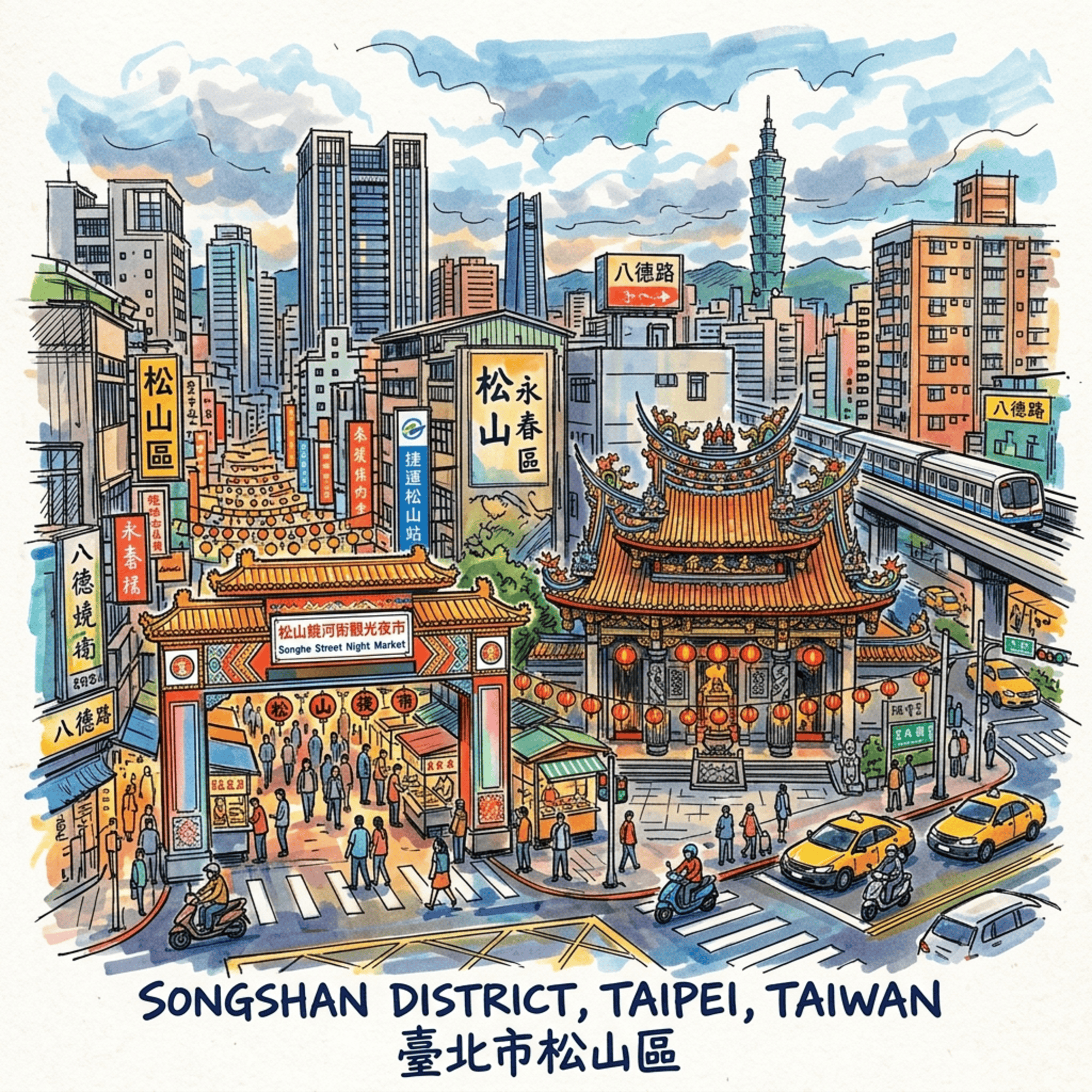
(ENG) Songshan, Taipei: Five Sites Where History Refused to Leave
A historical walking guide to Songshan, Taipei. Following the sharp bend of the Keelung River, this guide uncovers five overlapping eras—from indigenous erasures and rotated temples to wartime airfields—offering a deep sensory journey through three centuries of urban transformation.

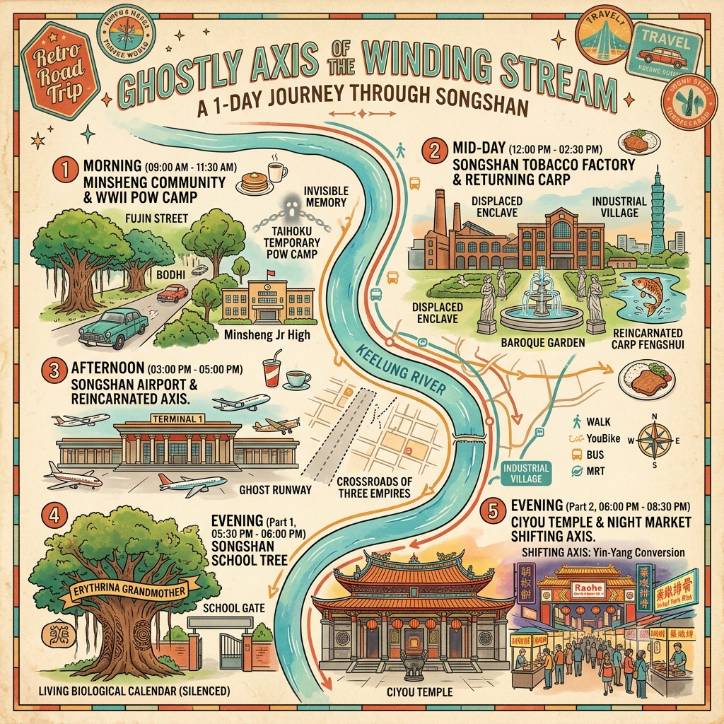
This is a historical travel story and walking guide to Songshan, a dynamic district in Taipei centered around a sharp bend of the Keelung River. Through five layered histories, it explores ancient temples, a colonial airfield, forgotten military ground, and misplaced industrial heritage to show how indigenous roots, imperial ambitions, and modern urban planning overlap on this shifting landscape. Readers will gain a deep sensory perspective and a curated route to uncover the hidden temporal layers beneath the city's modern surface.
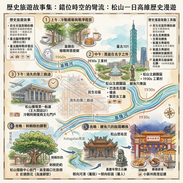
The Keelung River bends once, sharply and without apology, as it leaves the hills and enters the Taipei Basin. Everything that matters about Songshan begins and ends with that bend. The Basay people of the Ketagalan confederation named this place Malotsigauan — where the river curves — before any map existed to confirm their observation, and they were right in a way that has proved more durable than every subsequent renaming the site has been made to endure. Sikkou. Matsuyama. Songshan. Each name arrived with a government behind it and departed with that government's collapse, leaving the bend itself exactly where it had always been, at the same angle, carrying the same mineral-cold water toward the same basin. What follows is not a history of the names. It is a history of what the names could not cover: five sites, layered one over the other on this curve of river, that have each in their own way refused to become what the era around them required them to become.
Listen to the historical stories told in detail (For subscribers only)
Five Layers: The Human Record
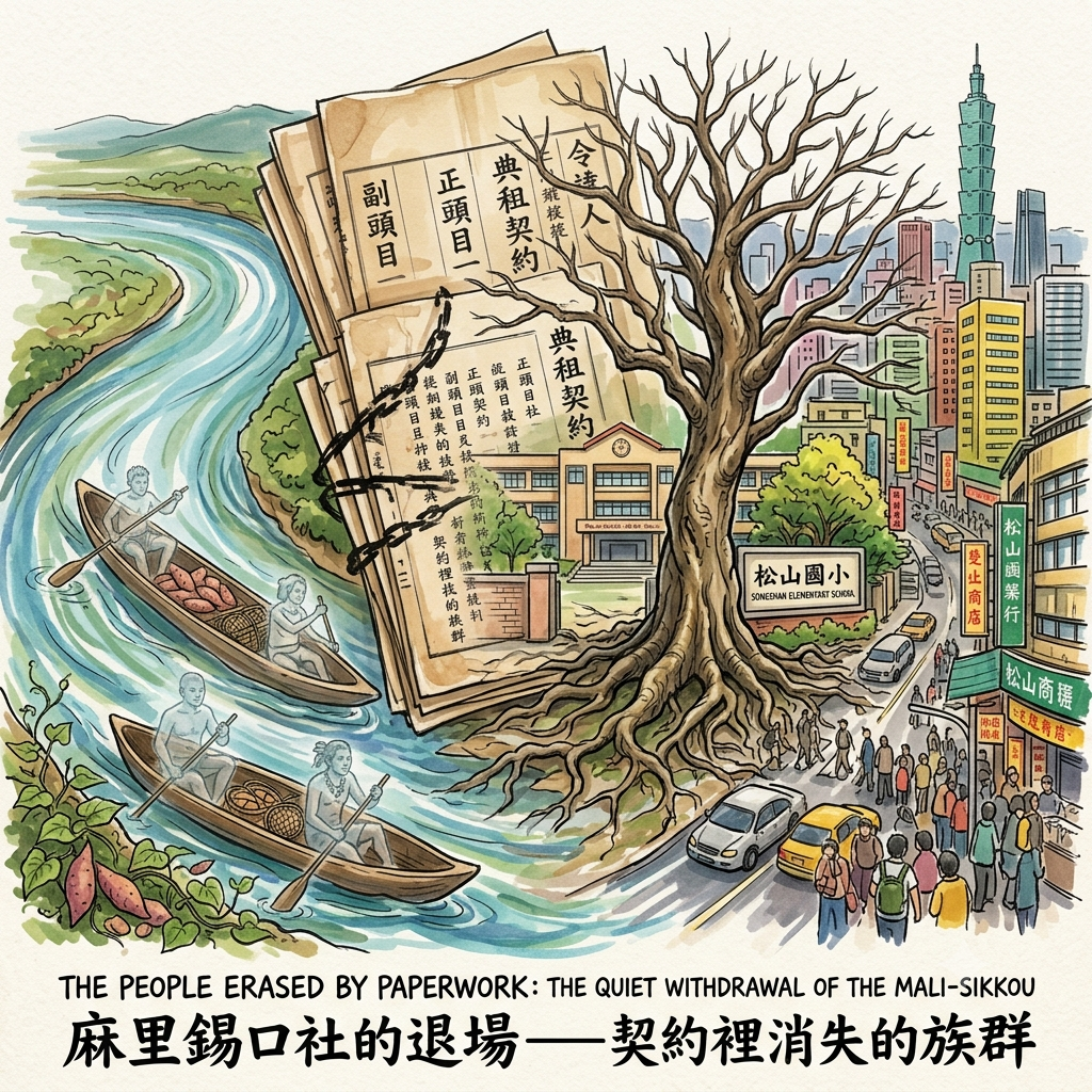
Node One — The People Erased by Paperwork
The first layer is the oldest and the least visible, which is precisely the point. Before the Qing-era settlers arrived with their tenancy agreements and their ink-brushed columns of characters, the Mali-Sikkou, Tatayou, and Lichi communities of the Ketagalan people fished this bend of the Keelung River from dugout canoes and cultivated sweet potatoes on its banks. That much the historical record concedes. What the record does not concede — because it cannot, being written entirely by the people who displaced them — are individual names. The Qing gazetteers preserve head chief, deputy head chief, the administrative scaffolding of a society, without preserving a single person's name from within it. The compression of an entire people into a set of job titles is not an accidental omission. It is the structural shape of erasure when erasure is too slow and too polite to call itself what it is.
Why Songshan's Oldest Tree Stopped Blooming
The displacement itself followed the same logic. Beginning in 1709, Han settlers from Fujian acquired tenancy rights to land the Ketagalan communities already occupied, through a system of leasing arrangements that appeared, on paper, to be mutually agreeable, and that proved, over the following century, to be a mechanism for making indigenous presence economically and eventually physically impossible. No battle marks the moment. No treaty registers the loss. The Mali-Sikkou community withdrew to Xizhi; the Lichi community to Neihu; the Tatayou community to the river's north bank. Each removal occurred quietly, at the pace of a contract rather than the pace of a cannon, which is perhaps why it left so little in the official record and so much in the ground.
The single living witness that remains is a coral tree — an old erythrina — growing behind Songshan Elementary School, identified as the largest surviving Ketagalan tribal tree in the city. The erythrina was not merely decorative. Its blossoming signalled the beginning of the harvest dance, a biological calendar calibrated to collective memory, a clock made of flowers. Locals will tell you, without particular emphasis, that the tree has stopped flowering in recent years. No one can say with certainty why. The arborists offer temperature shift and urban canopy change; the neighbourhood offers something harder to metabolise — the suggestion that a signal can persist without its receiver, and that a calendar is useless once the community it served has been dispersed. Whether one reads this as ecology or elegy or both simultaneously, the tree stands in its silence at the back of an elementary school, surrounded by the sound of a city that no longer remembers what it once meant to read it.
Node Two — The Temple That Changed Its Face, and the Rival Who Chose the Same Spot
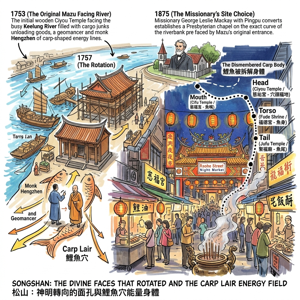
In 1753, a Buddhist monk named Hengzhen raised money from local merchants to build a temple on a site that geomancers had identified as a carp-shaped concentration of auspicious ground — a place where the river's underground energies pooled and focused in the formation the tradition calls a xue, a lair. The temple was dedicated to Mazu, goddess of the sea, and its original entrance faced the river. This matters. The river was where the money arrived: cargo junks carrying goods between Keelung, Yilan, and Wanhua made this bend their unloading point, and a goddess who faced the water was a goddess positioned toward the source of everything the settlement needed. Four years later, in 1757, the temple's orientation was physically rotated to face the street behind it instead.
This is one of the most precisely documented economic transitions I have encountered in the built environment of any city — not because anyone wrote an essay about it, but because the rotation of a building's entrance is a fact that cannot be revised in retrospect. The street market had displaced the river dock as the district's commercial axis, and the face of the divine was adjusted accordingly. The direction in which Mazu looks is, therefore, an economic record: a compass needle that has settled, in the masonry, on the moment when water-borne trade gave way to foot-traffic. You can stand in front of it today and read exactly when Sikkou stopped being a port and became a market town.
What happens next on this same piece of ground constitutes one of the more arresting coincidences in the district's history. In 1875, the Scottish missionary George Leslie Mackay led a congregation of Pingpu converts to the old ferry landing — almost precisely the point on the riverbank that Ciyou Temple's original entrance had once faced — and established there the tenth Presbyterian chapel in Taiwan. Two completely distinct cosmological traditions, separated by a hundred and twenty-two years and by every conceivable theological difference, independently selected the same coordinates on the same curve of the same river. No negotiation occurred. No one consulted the geomancers' notes. The landing simply offered itself, twice, to two different visions of where the sacred should be anchored, and both accepted.
The Invisible Fish of Songshan
The folk geography of the old market street extends this logic further: four temples distributed along the Raohe Street axis — Cifu Temple, Ciyou Temple, the Fude Shrine, and Jufu Temple — are described in the oral tradition as the dismembered body of a single carp, its mouth, head, torso, and tail located at four separate buildings, as though a single continuous field of significance had been discretised into stable architectural nodes to keep it from dissipating across the urban fabric. Whether this represents deliberate geomantic planning or retrospective interpretation layered over a coincidental distribution of neighbourhood shrines is, as the research dossier notes, a question that the surviving documentary record cannot definitively answer. Both possibilities are genuinely interesting.
Holographic Sensory Cue: the hour is six in the evening at the entrance to Ciyou Temple on Raohe Street, and the temperature is dropping from thirty degrees toward twenty-six at the rate of about a degree every twenty minutes, which is just slow enough to be felt as a change in quality rather than a change in number. The granite flags of the temple forecourt have been worn into a gentle concavity by three centuries of pilgrims' feet, and they still hold the day's heat in a way the surrounding air no longer does, so that standing on them is like standing on a body that is warmer than the room. Sandalwood smoke moves out from the temple's interior in slow horizontal layers and meets, without quite mixing, the sesame oil heating up in the wok of the stall immediately to the left. A wooden fish-drum sounds from somewhere inside at intervals of roughly four seconds; simultaneously, the first vendor of the evening calls out a price — the two sounds do not compete, they simply begin to share the air at the same moment, as the forecourt that has belonged all day to the goddess quietly begins its nightly transfer to the market. From the direction of the river, sixty metres to the north, a wind rises carrying its characteristic mineral dampness, the smell of silt and moving water, and somewhere beyond the temple's curved roof ridge, very faint and in no hurry, comes the sustained mechanical exhalation of a regional aircraft on final approach.
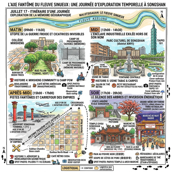
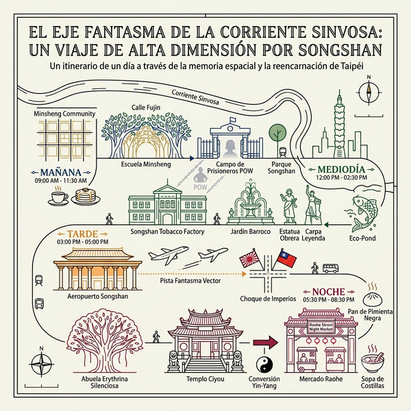
Node Three — The Runway That Died and Left Its Direction Behind
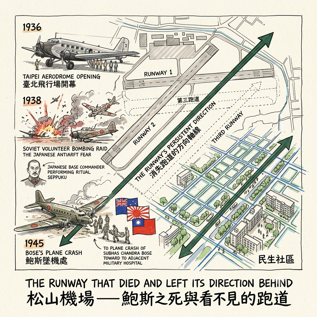
Taiwan's first civilian aerodrome opened on this stretch of the Keelung River's eastern bank in March 1936, with scheduled services to Naha and Fukuoka and ambitions for routes to Saigon, Guangzhou, and — a plan that never advanced beyond correspondence — the European network of Deutsche Lufthansa. The airfield's civilian life lasted approximately fourteen months. By the summer of 1937 it had been militarised, its timetables replaced by sortie schedules, its terminal staff by ground crews servicing bombers.
In February 1938, Soviet volunteer pilots flying from Nanchang made the airfield the first site in Taiwanese history to suffer a foreign air raid, destroying more than a dozen aircraft on the ground and causing sufficient political damage that the Governor-General of Taiwan was removed from his post and the base commander took his own life by ritual disembowelment. By the war's final year, American bombing runs had added their own damage to the accumulated wreckage, and on 15 August 1945 the airfield stood, battered and only partially functional, at the moment of Japan's surrender broadcast. Three days after that surrender, on the afternoon of 18 August 1945, Subhas Chandra Bose — the exiled leader of the Provisional Government of Free India, the man who had spent a decade attempting to leverage Japan's wartime position into the mechanism of British India's collapse — boarded a transport aircraft here bound for Tokyo. The plane crashed on takeoff. Bose was carried to the military hospital adjacent to the runway with severe burns, and died there within hours.
How Ghost Runways Shaped Taipei
I find I cannot pass over this death quickly. There is something almost geometrically exact about the circumstances: a man who had devoted his life to bending the arc of imperial collapse toward a particular outcome, who had allied himself with one empire to destroy another, dying on the tarmac of a colony in the precise three-day interval between the surrender of the empire he had allied with and the arrival of the next administrative authority. Not in Delhi, where his cause had its meaning. Not in Berlin or Tokyo, where his alliances had their leverage. On a regional runway in Taiwan, at the seam between two regimes, too late by seventy-two hours to have any further role in what came next. Three imperial trajectories — British, Japanese, and the arriving Republic of China — briefly occupied the same physical coordinates, and then each moved on, leaving him behind.
A further layer exists beneath the visible record. During the war's final year, a third runway was constructed at the airfield to handle increased military traffic. After Japan's surrender, it was decommissioned: the tarmac lifted, the foundations buried, the runway erased from every subsequent map. What several local historians have proposed — and this remains a hypothesis resting on popular historical writing rather than peer-reviewed urban research, and should be read accordingly — is that the axis of this ghost runway quietly informed the street orientation of Minsheng Community, which was laid out on adjacent land two decades later. If the proposition is eventually verified, it would constitute a precise physical instance of the Daoist principle that form may dissolve while the underlying disposition — the shi, the directional charge of a thing — persists. The runway's surface is gone. Its direction, these researchers suggest, is not. The death of an airport produced the skeleton of a neighbourhood.
Node Four — The School Built on Forgotten Ground
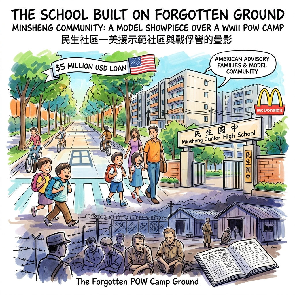
The land east of the airfield was kept clear for decades by flight-path restrictions — a buffer zone imposed by military planners that had the accidental side effect of preserving one of the last large open tracts in the Taipei Basin at a moment when the rest of the city was building rapidly outward. When the restrictions were partially relaxed in the mid-1960s, the American government extended a five-million-dollar loan for its development, and the result, Minsheng Community, was laid out according to the neighbourhood unit theory of the American planner Clarence Perry, first published in 1929: a grid of streets resembling the Chinese character for "field," 田, schools within four hundred metres of every household, the country's first underground electrical infrastructure, a building-height limit imposed by the airport's continued flight path that kept the neighbourhood low, wide, and — by Taipei standards — unusually bright and walkable. American military advisory families moved in. The first McDonald's in the country opened nearby. The whole development was, in the vocabulary of the era, a model community, a showpiece of what American capital and planning expertise could produce in an allied nation's eastern urban fringe.
The School Built on Forgotten Ground
What the showpiece was built upon is the detail that no official brochure has chosen to feature. Between 1942 and 1945, the land on which Minsheng Junior High School now stands served as Taipei's temporary prisoner of war camp, one of fifteen such facilities that existed across Taiwan during the Japanese occupation, interning Allied soldiers captured in the Pacific theatre. In 1969, the school was established on the site. Today there is no plaque at the gate. There is no interpretive sign anywhere on the grounds. The school's own published history does not mention the camp. Taiwan has sixteen sites associated with Second World War prisoner of war detention — fifteen camps and the Taipei prison — and not one of them has been granted formal heritage protection status. This is not, researchers in this area have noted, a consequence of insufficient documentation: the Japanese military administration kept detailed records of who was held where, and those records survive. It is a consequence of a heritage designation system that has not, across eight decades, moved these sites through its review process. The absence is institutional, not archival.
Every morning, children walk in through the school gate and cross ground that once held men whose names were recorded by the same bureaucratic precision that otherwise preferred not to preserve anyone's individuality. The children do not know this. There is no mechanism in place to tell them.
Node Five — The Factory Whose Name Outlived Its Address
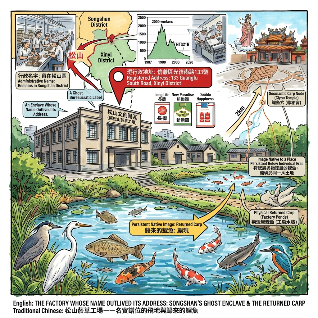
The fifth and final layer arrived not as a conquest or a community plan but as a cigarette. In 1937, the Governor-General's Monopoly Bureau contracted the construction of Taiwan's first modern tobacco processing facility on land then administered as part of Matsuyama Township — and because the land was called Matsuyama, the factory was called Matsuyama, and because the factory was called Matsuyama the name has adhered to it through every subsequent political transformation, regardless of what the maps around it have been made to say. The building now known as the Songshan Cultural and Creative Park carries the district's name in its title, its signage, its historical interpretation, and every article written about it. Its registered address is 133 Guangfu South Road, Xinyi District.
The Glitch in Taipei s Map
The administrative dislocation occurred through the accumulated boundary adjustments of postwar municipal expansion. At some point in the decades between 1945 and the present — the precise year is documented in city government records that are not easily accessible through public-facing databases — the boundary between Songshan District and its southern neighbour Xinyi District was redrawn in a way that placed the factory on the Xinyi side of the line. The building never moved. It simply found itself, one administrative revision later, in a different district, carrying a name that now referred to a place it no longer technically occupied. This is a ghost in the most literal bureaucratic sense: a label whose referent has been relocated while the label itself remains fixed to the object.
The factory operated through the full span of postwar economic development, employing roughly two thousand workers at its 1987 peak and generating revenues that provided meaningful support for government finances across several decades, producing forty-odd cigarette brands under names — Long Life, New Paradise, Double Happiness — that read now as a kind of compressed history of aspirational postwar affect. It closed in 1998. Left alone, the grounds began to rewild in the manner characteristic of East Asian industrial sites in subtropical climates: night herons arrived, then kingfishers, then egrets. The ponds, which had been part of the factory's operational infrastructure, filled with fish that no one had stocked — crucian carp, koi, catfish — in water that had not held them for decades. These ponds lie approximately two kilometres from the site of Ciyou Temple, built on the geomantic carp-shaped node of Sikkou's founding mythology. The symbol that geomancers inscribed into the ground three hundred years ago in the form of a temple orientation, and the living fish that returned without invitation to an abandoned industrial pond — these are different events, operating through completely different mechanisms, pointing at the same image. I am not arguing for a causal connection. I am noting that certain images appear to be native to a place in ways that persist below the threshold of any individual era's ability to explain or eliminate them.
The High-Dimensional Reading: A Syndrome of Displaced Names
Conventional historical method treats these five nodes as the subject matter of five different disciplines. Indigenous displacement belongs to anthropology and colonial history. The temple belongs to religious studies and architectural history. The airport belongs to military history and aviation heritage. The planned community belongs to urban planning scholarship. The tobacco factory belongs to industrial and economic history. Each discipline has its own archive, its own peer-reviewed apparatus, its own standard of evidence. None of them, proceeding within its own boundaries, is equipped to ask the question that arises when all five are placed on the same map at once: what is it, beneath each successive naming of this place, that has not changed?
The angle of the river's bend has not changed in three hundred years. The 1757 reorientation of Ciyou Temple's entrance did not establish a new geometry — it registered, with unusual architectural precision, the moment when the district's animating energy (the word the geomancers would have used is qi, a term that English reduces to "energy" but which points more specifically at the directional charge of a living system, the way a thing organises the space around it) shifted from the water to the street. The carp-body distribution of four temples along the Raohe Street axis represents, whether by design or retrospective interpretation, an attempt to discretise a continuous field into stable nodes — to break a long sentence into clauses so it doesn't collapse under its own weight. The ghost runway's proposed influence on Minsheng Community's street grid — held, with appropriate caution, as an unverified hypothesis — would, if confirmed, represent what the Daoist tradition means when it says that xing, physical form, may dissolve while shi, disposition or directional tendency, persists. And the tobacco factory's name, still attached to a building that its postal address has abandoned, is a demonstration of the same principle in the purely linguistic register: a signifier whose signified has been administratively relocated, continuing to point at a territory it no longer occupies.
The pattern that emerges across all five nodes is what the research dossier calls a naming-displacement syndrome: each successive regime, each new infrastructure project, each rebranded industrial zone arrives believing it is writing on a blank surface, when in fact it is writing on the ruins of the previous inscription, while the geological and geometric substrate beneath — the bend, the ferry landing, the runway's proposed ghost axis, the factory's pond — maintains its continuity indifferently, unaffected by whichever administration happens to be issuing the relevant paperwork at any given moment. The ground here remembers considerably longer than any of the names it has been required to wear.
Resonance Node: Minsheng Junior High School — the gate carries no plaque. The grounds contain no marker. The school's physical presence is entirely ordinary: concrete, basketball courts, the sounds of an institutional day in progress. What distinguishes this site is not what it contains but what it refuses to acknowledge — which is that the earth beneath these courts held, between 1942 and 1945, men interned as prisoners of war, whose names the Japanese military recorded with a thoroughness that no subsequent public authority has seen fit to match with an equivalent act of memory. This is the place in Songshan where the distance between what happened and what is allowed to be said about it is at its most measurable. The silence here is not ambient or accidental. It has been maintained, across eight decades, by institutional decisions that were never required to justify themselves in public. Standing outside the gate on an ordinary school morning, hearing the bell and the basketball and the teacher's voice carrying through an open window, one is in the presence of an archive that has been kept in a form specifically designed to prevent anyone from reading it. That, too, is a kind of historical document.
A Philosophical Anchor: What Persists Below the Names
Walking this district slowly, over several days and in several directions, I kept returning to a version of the same question: what is the relationship between a place's names and its actual identity, and which of the two is more likely to survive a change of government? Songshan's answer, spread across three centuries and five nodes, seems to be that the names are always provisional — administrative conveniences that each era imposes and each subsequent era is free to revoke — while something else, some combination of the river's angle and the ferry landing's coordinates and the geomantic structure that the temple builders read in the ground, persists below the level at which naming operates. This is not mysticism. It is a structural observation about the different rates at which political systems change and geographies change, and about the kinds of residue that accumulate in the gap between those rates.
In an era when any landscape can in principle be synthetically rendered by systems that have no memory of having stood in it, the scarcity that remains is not the image but the weight that accumulates only through time and attention and the willingness to ask what a place was made to forget before it was allowed to become what we see. Songshan was made to forget five things, at least, that its ground still carries: a people, a goddess's original orientation, a runway, a camp, a factory's proper address. None of these forgettings was complete. All five remain legible, to varying degrees, in the physical record of the district. That they are legible is the argument for continuing to look.
If you find some use in this kind of looking — in pieces written from the ground up, attentive to what the official record elides — you are welcome to subscribe, and I will keep sending you what I find, one bend in the river at a time.
Accessing the Physical Node
Getting there: The Taipei Metro Songshan Line and Wenhu Line both serve Songshan Station; Ciyou Temple and the Raohe Street night market are approximately ten minutes on foot from the exit. For the Minsheng Community grid and Songshan Airport's terminal building, Nanjing Sanmin Station or Zhongshan Junior High School Station connect more directly, with a short bus connection or fifteen-minute walk from either.
A suggested itinerary across the five nodes: Begin at the erythrina tree behind Songshan Elementary School — approach the back gate in the morning, before the school day fills the street with noise, and spend a few minutes with the silence of a tree that no longer flowers. Continue south to Ciyou Temple on Raohe Street, arriving in the late afternoon to witness the forecourt's transition from temple to night market at dusk, which is the district's most legible daily demonstration of layered time. The following morning, walk the Minsheng Community grid via Fujin Street — the low canopy, the wide pavements, the strange American ease of the residential blocks — and pause outside Minsheng Junior High School long enough to register what the gate does not say. End at Songshan Cultural and Creative Park: the baroque garden, the ecological pond, the fish that came back on their own, the factory name pointing at a district whose border has since moved.
Where to stay: Small hotels near Raohe Street or Songshan Station allow you to walk to the temple forecourt before the morning crowds establish themselves, which is the best time to feel the stone's residual warmth and the forecourt's emptiness in the same moment. Travellers drawn specifically to the Minsheng Community's mid-century residential texture might prefer one of the design-oriented guesthouses that have opened within the grid itself, which allow you to wake up inside the street plan rather than simply passing through it on a day visit.
Guided walks: Several Taipei community colleges and cultural foundations run periodic walking lecture programmes — known locally as zoudu, "walking-reading" — led by historians with specialist knowledge of the district's layered past, covering the old market street, the temple, and the riverbank in a single continuous sequence. Checking with the Songshan District Office or a nearby community college before travelling is the most reliable way to find an upcoming session; the programmes tend to run on weekends and vary seasonally.
Reference and Further reading
First layer – Main sources of literature and institutions:
- 國家文化記憶庫「麻里錫口社」條目(文化部,tcmb.culture.tw);
- 臺北市松山區公所官方歷史沿革頁面。
- 財團法人台北市松山慈祐宮官方歷史頁面(廟誌記載創建年代與座向變遷);
- 臺北市松山區公所地名沿革紀錄。
- 國家發展委員會檔案管理局「島嶼重整:戰後松山機場的接收與轉型」國家檔案專文;中華民國交通部民用航空局歷史資料;
- 松山空襲維基百科條目所引述之中蘇官方估計數據。
- 臺北市松山區公所歷史沿革;
- 國家文化記憶庫「民生社區的發展」條目;
- 維基百科「臺灣戰俘營」條目所列十五處戰俘營清單(含臺北臨時戰俘營/今民生國中)。
- 臺北市政府文化局松山文化創意園區官方檔案頁面(含正式行政區地址登錄:信義區光復南路133號);
- 〈臺北市定古蹟松山菸廠調查研究計畫〉,臺灣記憶資料庫(國家圖書館)。
The second layer – secondary academic materials:
- 黃叔璥《臺海使槎錄》番社六考;
- 余文儀《續修臺灣府志》卷二番社;
- 郁永河《裨海紀遊》。
- 金車文教基金會「大松山千人走讀」活動紀錄(松山文史研究工作者吳智慶筆記引用)。
- 洪致文〈風在城市街道紋理中的歷史刻痕——二戰時期台北簡易飛行場的選址與空間演變〉,《地理學報》59期,2010年,頁81-104;
- 何鳳嬌〈戰後初期臺灣軍事用地的接收〉,《國史館學術集刊》17期,2008年,頁167-199。
- 臺北市松山社區大學〈民生社區:都市計畫與美軍歷史交織的城市風景〉專文;
- 蕭文杰〈談負面文資的保存:請守護僅存的台灣戰俘營遺址〉相關評論。
- 松山文創園區官方歷史回顧頁面所載建廠規劃細節與「工業村」概念說明。
Third layer – Supplementary information:
- CTnews書刊地方文史報導(刺桐樹現況);
- 松山慈祐宮官方歷史頁面。
- 地方走讀導覽口述歷史(鯉魚穴四廟分布傳說);
- PeoPo公民新聞中崙囝仔走讀錫口系列報導。
- 故事StoryStudio〈從軍事基地到民航樞紐:戰後松山機場的轉型與再造〉;
- 聯合新聞網「童年懷舊鄉野談」專欄關於第三跑道與民生社區街廓關聯之報導。
- Readmoo閱讀最前線〈民生社區的榕樹下、院落前〉(作家愛亞口述歷史);
- 聯合新聞網鳴人堂〈走過時間的她:另一個視角下的民生社區〉。
- 交通部觀光署松山文創園區介紹頁面;
- 旅遊王TravelKing松山文創園區景點介紹(生態現況描述)。
史學斷層與矛盾:
- The theory that the "Great Taipei Lake" was formed by a massive earthquake in 1695 remains a subject of debate within geology and historical geography; some scholars question the event's scale and extent, advocating for further verification against primary records. Furthermore, the phrase "combining warfare with negotiation"—often used to describe the migration of Indigenous peoples—is ambiguous regarding the actual degree of armed conflict versus economic displacement. Existing Han Chinese documents offer largely one-sided accounts and lack corresponding historical records from an Indigenous perspective—a situation that represents a structural silence in historiography rather than a mere absence of source material.
- The legends associated with the four temples of the "Carp Site" constitute oral local knowledge; there are no extant original geomantic documents to substantiate a systematic plan. Further verification via primary archives is recommended—specifically regarding the precise construction dates of smaller temples such as Jufu Temple and Fude Palace—to determine whether the "Carp Body" narrative is a retrospective interpretation or reflects an actual historical planning intent. Similarly, the question of whether the exact location where Mackay established the Xikou Church and the river-port ferry landing (which determined the original orientation of Ciyou Palace) share the same physical coordinates relies currently on anecdotal local historical accounts; lacking direct comparison based on cartographic data, this matter also warrants further investigation.
- Accounts regarding the precise cause of Bose's death—whether due to mechanical failure, pilot error, or other factors—vary across international historical records; the truth of the matter has long been a subject of dispute among Indian officials and historians (with some conspiracy theories even claiming he did not actually die), making it a topic of enduring debate in the international historical community, and further verification against primary archival sources is recommended. The alleged causal link between the alignment of the third runway and the street layout of the Minsheng Community currently appears primarily in popular media reports rather than in rigorous academic studies of urban history; this claim should therefore be treated as a hypothesis requiring further validation.
- None of the sixteen surviving World War II POW-related sites in Taiwan (comprising fifteen POW camps and the Taipei Prison) have yet been granted statutory status as cultural assets. Researchers have explicitly identified this as a form of institutional silence—it is not a lack of historical evidence, but rather a failure of the review mechanism to incorporate these sites into the cultural heritage system over the long term. Minsheng Junior High School stands on the site of a former temporary POW camp in Taipei, yet neither the school nor the city government has installed any explanatory plaques or memorials there. Compared to sites like the Jinguashi POW Camp, academic documentation regarding the specific scale, number of prisoners, and conditions at this camp remains relatively scarce; further verification of original archives is recommended, and inquiries regarding additional historical materials could be directed to civic organizations such as the Taiwan POW Camps Memorial Society.
- Regarding the history of administrative boundary changes for the site of the Songshan Tobacco Factory—specifically, when and through what municipal reorganization it was formally incorporated into Xinyi District—currently available public information merely states its "current status as part of Xinyi District" but lacks documentation detailing the full timeline of boundary shifts. It is recommended that original records be consulted; inquiries regarding the precise year of the boundary adjustment and the relevant legal basis could be directed to the Department of Civil Affairs or the Land Administration archives of the Taipei City Government. Furthermore, regarding the concept of the "industrial village" and whether it embodied a dual nature involving colonial labor control—whereby welfare facilities served simultaneously as management tools to enforce production discipline and reduce worker turnover—existing official narratives tend to emphasize the positive aspects of employee welfare while largely overlooking the dimension of labor control; this represents a historiographical gap worthy of further critical study.

The sources for this article include primary historical records, academic papers, and public records from various levels of administrative bodies, with a commitment to historical accuracy; instances requiring further verification against primary archival materials have been noted in the text. Last updated: July 2026.