(ENG) Tokyo Azuma-cho Historical Walk: The Silk Rebellion and the Awakening of the Factory Gates
Before the modern housing estates of Sumida, there were the chimneys of the Tokyo Muslin factory. Discover the story of Yamauchi Mina and the 1914 strike that redefined Tokyo’s industrial landscape. A deep dive into the "Female Worker's Sad History" and the fight for dignity in Azuma-cho.

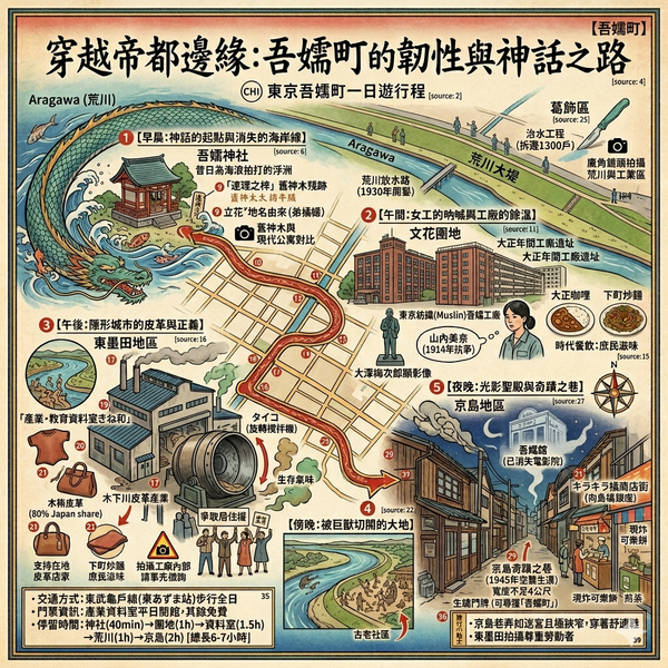
This is a historical travel story and walking guide to Azuma-cho, an industrial district in Sumida, Tokyo. By retracing the footsteps of 14-year-old Yamauchi Mina and the 1914 Tokyo Muslin strike, it explores the transition from sacred groves to factory chimneys and the birth of labor consciousness. Readers will discover how the "topography of labor" shaped this corner of Tokyo, transforming it from a site of hardship into a symbol of dignity and modern urban housing.
The Invisible Architecture of Sumida
To comprehend the modern sprawl of Tokyo, one must look beyond the curated neon of the western wards and turn toward the "industrial gears" of the East. Azuma-cho—a district largely absorbed into present-day Sumida—exists as a profound social experiment site positioned between the shifting currents of the Sumida and Arakawa rivers. This area evolved through an urban palimpsest, transforming from a sacred "floating island" in a primitive bay into a heavy industrial base essential to the empire’s modernization.
As a cultural geographer, I argue that the strategic importance of this "peripheral landscape" cannot be overstated; the edges of the city have historically anchored its growth, absorbing the labor and "unclean" industries that the center preferred to keep out of sight. To understand the Tokyo of today, one must analyze the topography of labor and the ancient boundaries of Azuma. By peeling back the modern concrete, we find a story of resilience etched into the very soil, beginning with a sacrifice that defined the East.
Listen to the historical stories told in detail (For subscribers only)
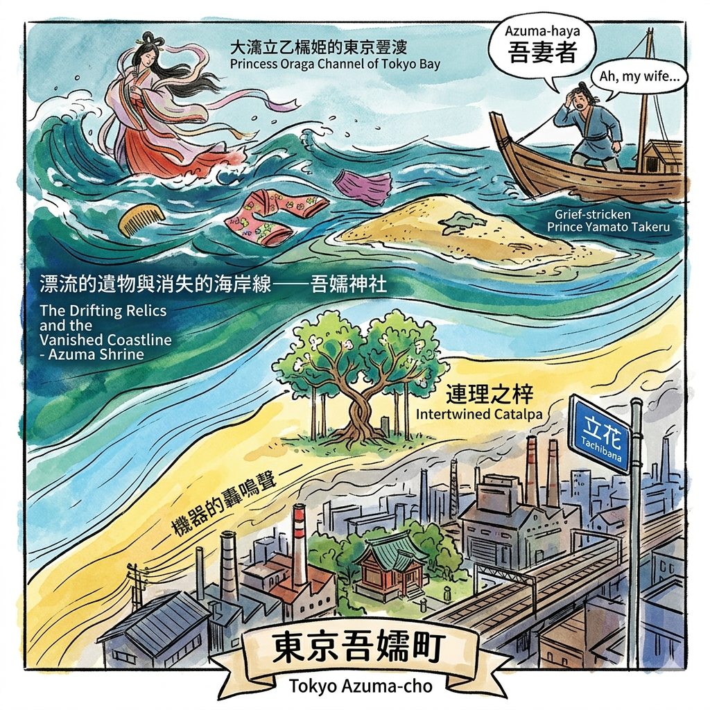
The Sacred Edge: Princess Ototachibana and the Shifting Coastline
The history of Azuma-cho begins at the water’s edge, where the Azuma Shrine has stood as a spiritual border marker since the 2nd century. It marks the liminal space between the Yamato central power and the wild Kanto frontier. The shrine commemorates the sacrifice of Princess Ototachibana-hime, wife of the legendary Prince Yamato Takeru.
According to the Kojiki, the Prince’s fleet was trapped by a tempest in the Uraga Channel. To appease the sea gods, Ototachibana-hime cast herself into the waves. Seven days later, her sacred heirlooms—her comb, clothing, and sleeves—washed ashore on a sandbank in what was then the depths of Tokyo Bay. The Prince buried these relics and, consumed by grief, cried out:
"Azuma-haya" (Ah, my wife...)
This "Azuma" (my wife) eventually became "Azuma" (the East), a linguistic fossil of mourning. The princess's name lives on in the modern district name Tachibana, a permanent mark on the urban map. For the visitor, the most tangible link is the "Renri no Azusa" (Intertwined Catalpa trees) within the shrine grounds—a botanical representation of the couple’s bond. This legend serves as geographic evidence of the ancient coastline; the drifting of these items to this specific sandbank highlights the historical accumulation of silt that would eventually form the ground for Tokyo's industrial revolution.
The Silk Rebellion: 14-Year-Old Yamauchi Mina and the Factory Gates
By the late Meiji era, the sacred groves were eclipsed by the chimneys of the Tokyo Muslin Azuma Factory. As Japan sought to dominate global fiber exports, Azuma became a core textile base, fueled by an influx of rural workers from the northeast. This period gave rise to the "Female Worker's Sad History" (Joko Aishi), where labor was characterized by brutal conditions and dormitory imprisonment.
In 1914, a massive labor dispute erupted when the factory announced 1,000 layoffs. At the vanguard was Yamauchi Mina, a 14-year-old girl from Miyagi. This was not merely a strike for wages; it was a burgeoning of gender and class consciousness.
Key Actor | Scale of Dispute | Socio-Spatial Impact |
Yamauchi Mina | 1,000+ layoffs | Transitioned workers from "invisible" dormitory residents to political agents. |
Suzuki Bunji | Founder of Yuaikai | Linked local industrial grievances to national labor movements. |
Tokyo Muslin | Leading textile base | Transformed a sacred site into a landscape of global capitalist production. |
This struggle marked the moment the "topography of labor" shifted; the factory gates, once meant to keep workers in, became the site where the marginalized first demanded a voice in the city's future.

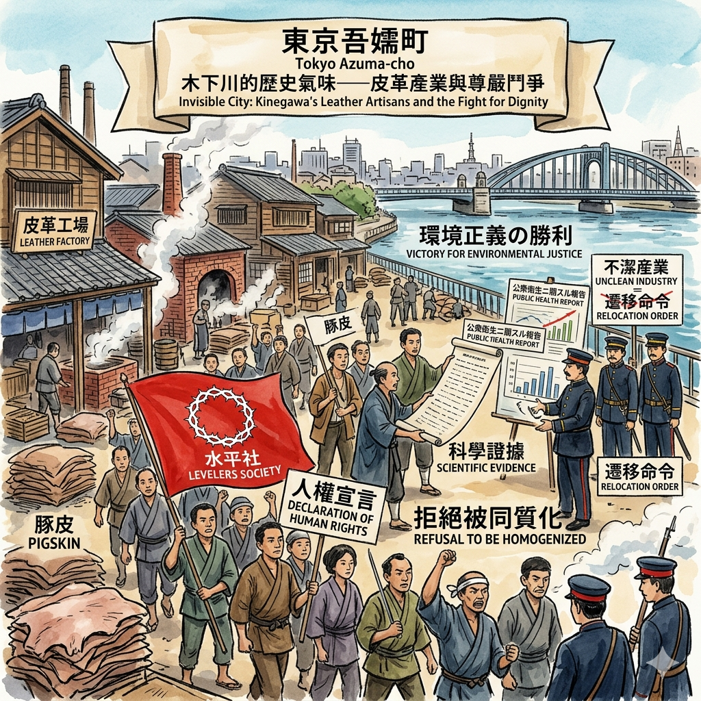
The Invisible City: Kinegawa’s Leather Artisans and the Fight for Dignity
Further toward the river's edge lies the Kinegawa district (now East Sumida), a place historically defined by spatial discrimination. During the Meiji era, the state pushed "unclean" industries—specifically leather processing—to the city’s periphery. This area became synonymous with the Buraku communities, marginalized groups who were geographically and socially isolated.
However, Kinegawa’s artisans demonstrated extraordinary community resilience. Through the "Suiheisha" (Levelers Society) movement of the 1920s, they fought for human dignity. A landmark victory for environmental justice occurred in 1933; the community successfully blocked a forced relocation by providing scientific evidence that their industry was not a public health hazard, countering the state’s narrative of "uncleanliness." Today, this area still produces over 80% of Japan’s pigskin—a testament to a community that refused to be homogenized by a city that relied on its leather while scorning its people.
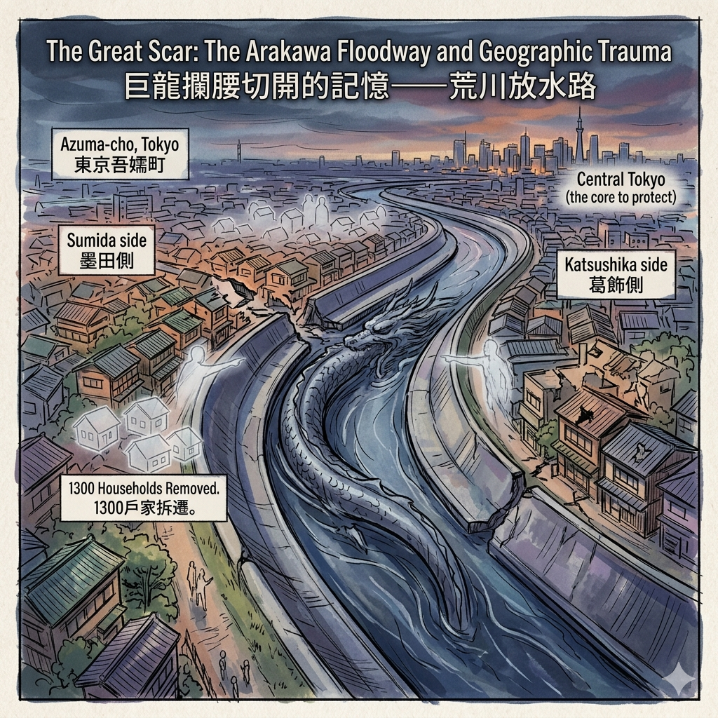
The Great Scar: The Arakawa Floodway and Geographic Trauma
The physical landscape of Azuma-cho was permanently severed not by war, but by "internal colonization." Following the Great Flood of 1910, the government initiated the carving of the Arakawa Floodway (1911-1930). This was an act of massive spatial violence: a 600-meter-wide artificial canal was cut through the heart of the community to protect the wealth of central Tokyo.
The project forced the removal of 1,300 households and 6,000 residents, creating a permanent spatial rupture. This watery divide fragmented local memory, splitting the neighborhood into "Sumida side" and "Katsushika side." The floodway stands as a monument to how the periphery is often sacrificed to preserve the core, leaving a scar in the landscape that dictates the movement of people to this day.
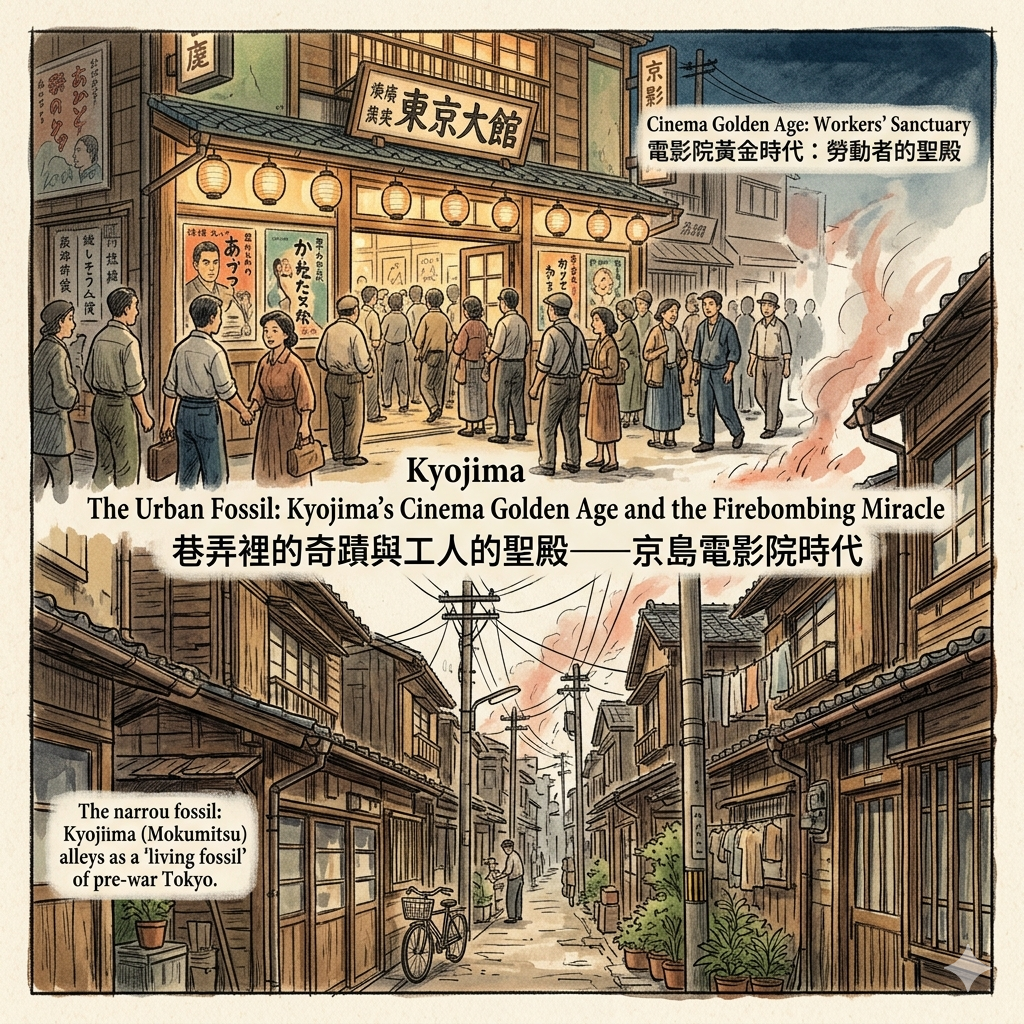
The Urban Fossil: Kyojima’s Cinema Golden Age and the Firebombing Miracle
In the 1930s, the dense industrial population of Azuma-cho fueled a golden age of cinema. Theaters like the Azumakan (est. 1909) were not just entertainment venues; they were built by local landlords as tools to retain labor, providing a "local sanctuary" for a weary workforce.
During the horrific firebombing of March 10, 1945, which incinerated the surrounding industrial wards, portions of Kyojima miraculously survived. Today, the area remains a "living fossil" of pre-war Tokyo, characterized by Mokumitsu—dense wooden housing and winding alleys. This "urban toughness" and defensive density preserved the vernacular landscape of the Taisho era. Kyojima is not a museum but a surviving piece of the old world, a testament to the stubborn survival of the working class.
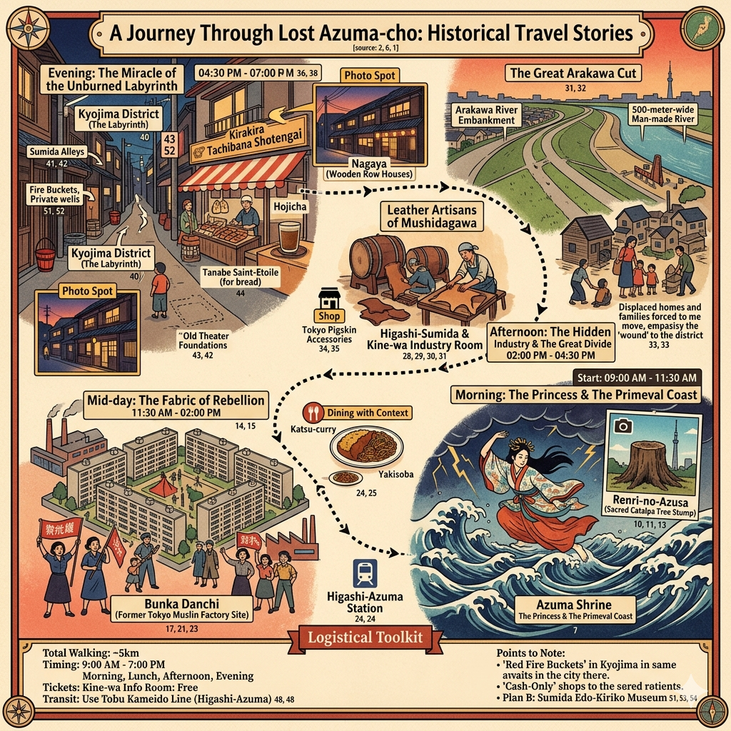
Walking Through Time: A Guide for the Thoughtful Observer
To experience Azuma-cho, the traveler must look for "layers"—the height of a levee, the chemical scent of a workshop, or the narrowness of an alley.
- Higashi-Azuma Station: The starting point. The name is a linguistic ghost of a ward that no longer officially exists.
- Bunka Danchi: Walk through this housing complex. Its orderly grid sits atop the former Tokyo Muslin factory site, a stark contrast to the organic alleys of nearby Kyojima.
- The Hidden Gem: The Kinegawa Industry and Education Information Room. Located in the Higashi-Sumida Kaikan, this is a site of resistance. Here, you can see the Taiko (rotating drum) machinery used in leather tanning and study the records of the community’s fight for civil rights.
- The Kyojima Alleys: Wander through the Mokumitsu area to feel the defensive urban form that survived the flames of 1945.
Philosophical Reflection: The Resilience of the Peripheral
The history of Azuma-cho is a narrative of "Peripheral Productivity." For over a millennium, this district has provided the sacred legends, the textile labor, the essential leather goods, and the flood protection that allowed central Tokyo to thrive. Yet, the city has often ignored or actively marginalized this "invisible" heart.
The stubborn survival of Azuma-cho suggests that a city’s true character is not found in its preserved monuments or its glass towers. Instead, it is found in the resilience of its forgotten edges—the places that refused to be erased by state-mandated relocation or geographic trauma. Does a city’s true character lie in its preserved monuments, or in the stubborn survival of its forgotten edges?
Logistics: How to Experience Azuma-cho
- Getting There: Take the Tobu Kameido Line to Higashi-Azuma Station. It is a short trip from the Hikifune hub.
- Nearby Tours: Conduct a self-guided walk through the Kyojima Mokumitsu area to see pre-war architecture.
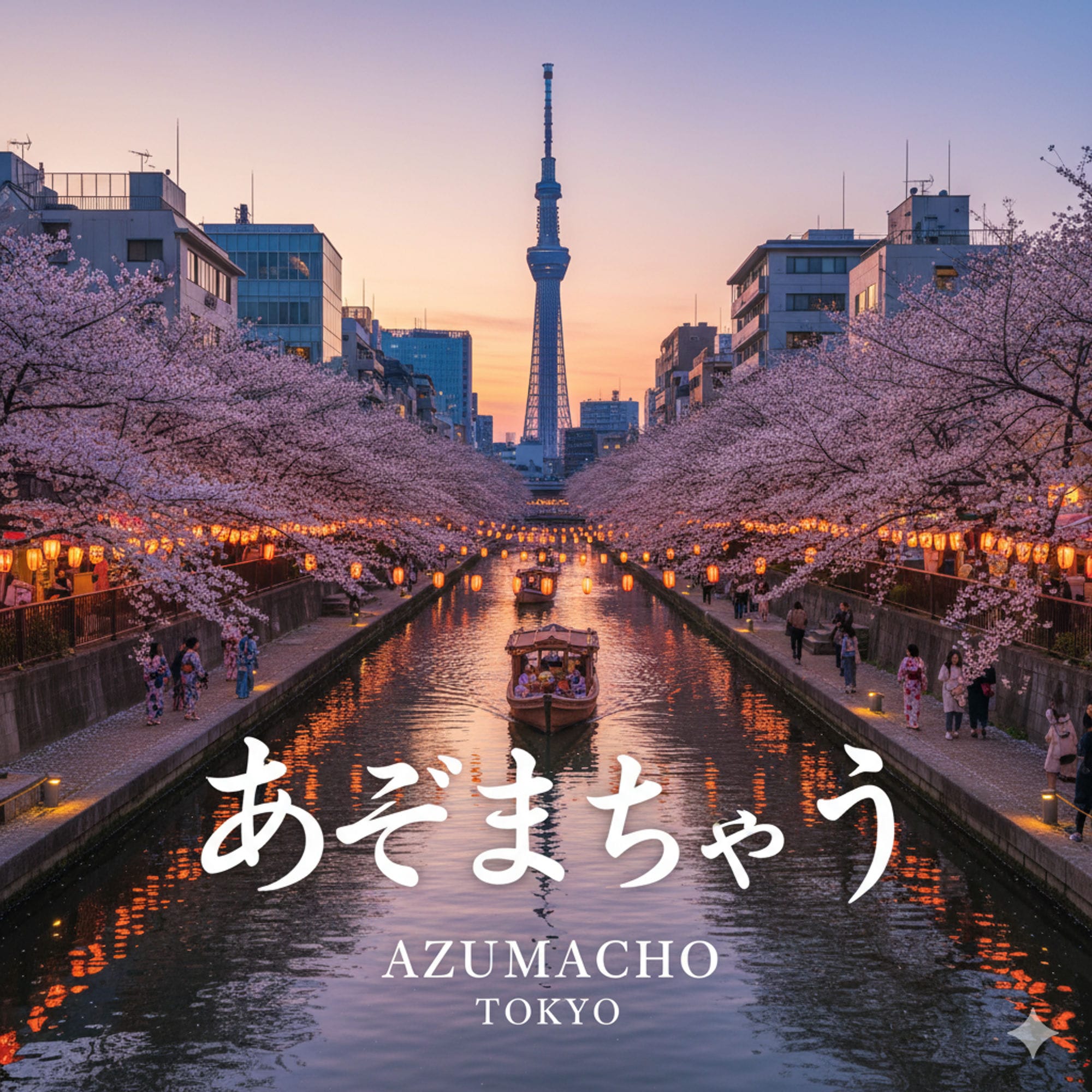
- Accommodation Tip: Stay in the Oshiage/Sumida area. The contrast between the looming Tokyo SkyTree and the low-slung, industrial roots of old Azuma-cho provides the essential context for understanding Tokyo’s layered modernization.
Q & A
How did the Arakawa Floodway physically and socially transform the town?
The excavation of the Arakawa Floodway (1911–1930) was a massive state-led engineering project that fundamentally altered both the physical landscape and the social fabric of Azuma-cho. Triggered by the catastrophic "Koushu Great Flood" of 1910, which affected 1.5 million people in eastern Tokyo, the project was designed to eliminate the threat of future flooding.Physical Transformation: The "Slice of a Giant Beast"Physically, the floodway acted as a "giant beast" that sliced the town in half, creating a permanent and insurmountable physical chasm where a unified community once stood.
- Scale and Scope: The project created an artificial river between 400 to 600 meters wide and approximately 22 kilometers long.
- Land Expropriation: To accommodate this massive channel, the government seized vast tracts of land, effectively erasing existing geographical features.
- Long-term Environmental Impact: The industrialization that followed the floodway's construction, specifically the extraction of groundwater, eventually led to significant land subsidence of up to 4 meters in the area.
Social Transformation: Displacement and FragmentationThe social impact of the floodway was profound, characterized in the sources as a form of "internal colonialism" where state modernization goals superseded local community needs.
- Mass Displacement: The construction necessitated the forced relocation of approximately 1,300 households, affecting more than 6,000 residents.
- Severing of Community Ties: The project physically cut off neighborhoods like Omurai and Kinegawa from their traditional connection to the Azuma Shrine. This division separated the region into the "Sumida side" and "Katsushika side," leading to a fragmented local history and identity that persists today.
- Dual Nature of the Space: Interestingly, the unfinished riverbed served a vital social function during the 1923 Great Kanto Earthquake, acting as an emergency shelter for 150,000 refugees, demonstrating the project's complex role in both disaster and recovery.
Historical LegacyThe Arakawa Floodway remains a symbol of "spatial violence"—the state's power to reorganize land regardless of existing social structures. Today, the wide riverbanks and levees define the boundary between Sumida and Katsushika wards, and the area continues to be a focal point for modern disaster prevention under the "TOKYO Resilience Project". The name of the "Higashi-Azuma" (East Azuma) station serves as a linguistic reminder that the area was once merely the eastern edge of a larger, unified town.
How did the legend of Oto-tachibana-hime shape Azuma-cho's identity?
The legend of Oto-tachibana-hime (Princess Oto-tachibana) played a foundational role in shaping Azuma-cho’s identity, transforming it from a desolate sandbar into a sacred site of imperial myth and enduring cultural memory.
1. Etymological and Geographical OriginThe very name of the town, "Azuma," is derived directly from this legend. According to the Kojiki and Nihon Shoki, after Oto-tachibana-hime sacrificed herself to the sea to calm a storm for her husband, Prince Yamato Takeru, her personal relics (such as her comb and clothing) drifted to a sandbar in what is now Sumida-ku. The Prince built a memorial mound there and cried out, "Azuma-haya" ("Ah, my wife"), cementing the area’s identity as the "Eastern Land" of his beloved. Furthermore, the modern district name "Tachibana" is a direct linguistic inheritance from the Princess’s name, serving as a permanent mark of her legacy on the urban landscape.
2. A "Sacred" Anchor in a Marginal LandscapeBefore its industrialization, Azuma-cho was a "marginal landscape"—a collection of sandbars or "floating islands" at the mouth of Tokyo Bay. The legend provided this peripheral area with a centralized sacred status.
- Azuma Shrine: Established to house the Princess's relics, the shrine became a historical anchor for the community, predating even the religious layers of Senso-ji Temple.
- The "Renri no Azusa" (Intertwined Trees): A legend grew around two trees at the shrine, said to have sprouted from the Prince's chopsticks, which became a symbol of marital harmony and "En-musubi" (matchmaking). This shifted the town's identity from one of "tragic sacrifice" to a popular pilgrimage site for commoners seeking blessings for love.
3. Historical and Geological EvidenceThe legend also shaped how the town's physical history is understood. The narrative of relics drifting to this specific location serves as historical evidence of the ancient coastline, confirming that the area was once an inlet of Tokyo Bay. This mythic framework has allowed modern researchers to trace the alluvial history of the Kanto Plain through the lens of sacred tradition.
4. Cultural Layering: The Sacred and the ProfaneOne of the most unique aspects of Azuma-cho’s identity is the "layering of the sacred and the profane". The town holds the dual identity of being the site of a high imperial legend while simultaneously being the historical home to marginalized industries, such as the leather-working communities of Kinegawa. This contrast defines the town's urban resilience, where the most sacred imperial myths coexist with the struggles of the working class and marginalized groups.Even as the town transitioned into a heavy industrial base and was physically fractured by the Arakawa Floodway, the legend of Oto-tachibana-hime remained a "living fossil" of its origins, preserved in the remaining roots of the sacred trees and the names of its streets.
Reference and Further reading
- 第2章 曳舟川周辺の歴史|6.吾嬬神社の伝説 | 向島四丁目北町会, accessed April 7, 2026,
- 20.吾嬬神社 - 押上一丁目仲町会, accessed April 7, 2026,
- 第331回活動記録 - 邪馬台国の会, accessed April 7, 2026,
- 『吾嬬の森連理の梓』:浮世写真家 喜千也の「名所江戸百景」第111回 | nippon.com, accessed April 7, 2026,
- https://www.nippon.com/ja/guide-to-japan/gu004111/
- 東吾嬬小学校, accessed April 7, 2026,
- 吾妻神社 - 弟橘姫媛の遺品を御神体とする神社 - 日本伝承大鑑, accessed April 7, 2026,
- 東京下町の労働運動と大正デモクラシー - 季刊・現代の理論, accessed April 7, 2026,
- 下町労働運動史 78 - 下町ユニオンニュース - FC2, accessed April 7, 2026,
- 下町労働史 89 - 下町ユニオンニュース, accessed April 7, 2026,
- (10/21)部落にルーツをもつ女性たちと巡る東墨田皮革産業地域, accessed April 7, 2026,
- 見聞|ご存じですか|東京人権啓発企業連絡会 - ひろげよう人権, accessed April 7, 2026,
- 見学 | Archives Kinegawa - 産業・教育資料室 きねがわ, accessed April 7, 2026,
- 皮革産業の振興により同和問題の解決を図ると表明 - 部落解放同盟東京都連合会, accessed April 7, 2026,
- 2024年 全国大学同和教育研究協議会・東日本部落解放研究所秋季企画, accessed April 7, 2026,
- 明治・大正・昭和期に行われた荒川放水路開削工事と 市民の生活, accessed April 7, 2026,
- 第2章 曳舟川周辺の歴史|1.荒川と荒川放水路 - 向島四丁目北町会, accessed April 7, 2026,
- 知っていますか?荒川放水路のこと「荒川放水路通水100周年」 - 足立区, accessed April 7, 2026,
- 荒川流域の歴史と地理 橋本淳司 - aqua-sphere, accessed April 7, 2026,
- 地震木造の住宅が密集した「木密地域」を火の手から守る 都や地域の ..., accessed April 7, 2026,
- 墨田区の映画館 - 消えた映画館の記憶, accessed April 7, 2026