(ENG) Hanabatake, Tokyo: The Forgotten Frontier Village Where Chickens Were Sacred, Canals Divided Families, and Peasants Solved Graduate-Level Geometry
A deep historical travel story and walking guide to Hanabatake, Tokyo. Once a waterlogged borderland of Edo, this neighborhood holds five incredible stories—from sacred chicken taboos and a Buddha worn smooth by desperate faith, to ordinary peasants solving complex geometry.

This is a historical travel story and walking guide to Hanabatake, a forgotten frontier village located on the waterlogged edge of Tokyo's Adachi Ward. Through five extraordinary local histories, it explores ancient shrines, hidden temples, and historical canals to reveal how sacred taboos, feudal lord obsessions, and grassroots peasant intellect shaped this unique Edo-period boundary.
The northeastern edge of Tokyo's Adachi Ward does not appear on most travel itineraries. There are no famous ramen shops here, no Instagram-optimized gardens, no landmark department stores. What there is — tucked among convenience stores, elevated expressways, and quiet residential blocks — is one of the most layered historical landscapes in the entire Kantō region.
Hanabatake (花畑), formerly known as Hanamata Village in Musashi Province's Adachi District, sits at the intersection of four rivers: the Nakagawa to the east, the Kegasawa and Garigawa to the north, and the Ayase River running through its center from north to south. For centuries, this waterlogged frontier zone served simultaneously as the agricultural fringe of Edo, a logistical hub for river trade, and a jurisdictional borderland where the shogunate's rules applied — but unevenly.

Five historical stories survive in the physical fabric of this neighborhood. Each one challenges something we assume about pre-modern Japan.
Why Hanabatake Matters to a Historically Minded Traveler
Hanabatake is not a destination for passive sightseeing. It rewards the traveler who walks slowly, reads surfaces carefully, and understands that meaning accumulates in small places. A featureless stone in a temple courtyard. A dragon carved on a shrine column. A cemetery tucked behind a highway wall. A mathematical wooden tablet in a distant shrine repository.
These are not remnants of grandeur. They are remnants of ordinary life in an extraordinary situation: a low-lying wetland village perpetually negotiating between flood, faith, governance, and intellectual hunger.
For visitors exploring Adachi Ward's historical landscape, Hanabatake functions as a microcosm of everything Tokyo's center has long since erased.
Listen to the historical stories told in detail (For subscribers only)
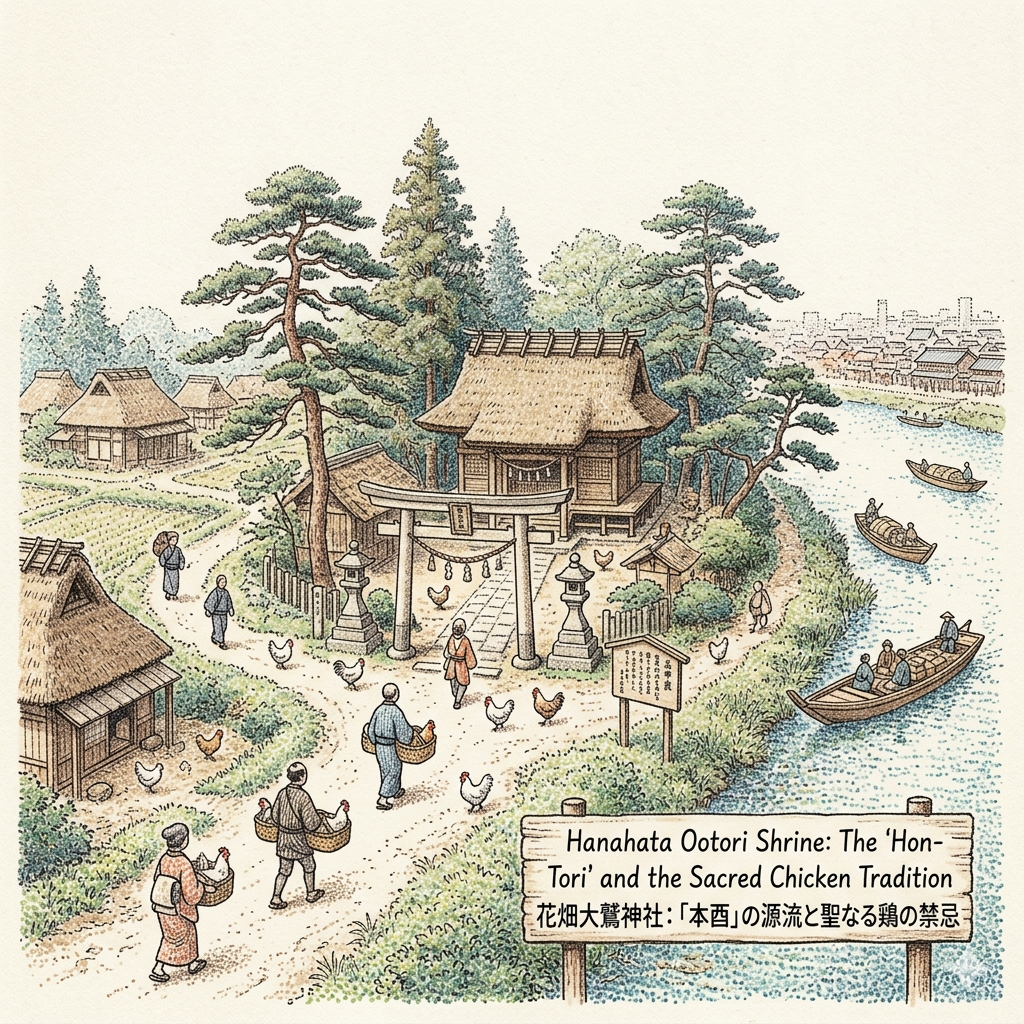
The Sacred Chicken Taboo: How Tokyo's Most Famous Rooster Market Began at the Edge of a Swamp
The Tori-no-Ichi (酉の市) festival is one of Tokyo's best-known autumn traditions. Every November, on the Day of the Rooster, enormous crowds fill the Asakusa Washi Shrine in pursuit of elaborately decorated bamboo rakes called kumade, said to sweep good fortune into one's hands. The stalls are theatrical, the crowds dense, the atmosphere loud and mercantile.
Almost no one attending the Asakusa festival knows that this entire tradition originated in a quiet shrine now sitting in the middle of a residential block in Hanabatake.
The Ōtori Shrine (花畑大鷲神社), originally called the Washi Daimyōjin, was established — precise founding date unknown — to enshrine Yamato Takeru, a legendary warrior prince. During the Ōei era (1394–1428), the shrine began holding an annual thanksgiving ceremony on the first Tori-no-Hi (Day of the Rooster) in November, believed to mark the death anniversary of Yamato Takeru. This gathering is now regarded as the oldest precursor to the Tori-no-Ichi festival anywhere in the Kantō region.
What made the original ceremony strange by modern standards was its relationship to living chickens.
On the festival day, local parishioners would bring their own domestically raised chickens as offerings to the Washi Daimyōjin, treating them as inviolable divine messengers. After the ceremony concluded, these ritually consecrated birds were not eaten. They were transported — in batches — to Sensōji Temple in Asakusa, where they were released alive before the Kannon Hall. From this practice emerged a dietary prohibition observed by the shrine's parishioners for generations: the community's worshippers were expected to abstain from eating chicken meat and eggs for their entire lives. This rule shaped the food culture of the local settlement for hundreds of years.
The crowd of pilgrims was said to be so enormous that it caused the great Senju Bridge to sink under their weight.
That anecdotal exaggeration captures something real: during Edo's middle period, the Tokugawa shogunate granted the shrine special permission to operate tsuji-bakuchi — open street gambling — during festival days. Because Hanamata Village sat at the jurisdictional margin of shogunate-controlled land (tenryō), bordering Shimōsa Province and Saitama District, the authorities used this geographic ambiguity as a social pressure valve. Thousands of Edo residents traveled upriver by boat along the Ayase and Nakagawa to gamble and pray.
In 1776, the shogunate abolished street gambling here on public order grounds. Commercial gravity shifted immediately toward the Asakusa Washi Shrine (now called Shimo-tori or "Lower Rooster"), which sat closer to the new Yoshiwara pleasure district and the city's entertainment economy. The Hanabatake shrine was demoted, in popular usage, to Kami-tori or Moto-tori: the "original" or "upper" rooster — which is, in fact, what it always was.
Today, the Hanabatake Ōtori Shrine remains tucked inside a residential neighborhood in Hanabatake 7-chōme, preserving the atmosphere of a village chinju (tutelary shrine). Several chikara-ishi — large stones used by Edo-era farm youth to test their strength in lifting competitions — survive in the precinct as registered cultural properties of Adachi Ward. Every twelve years, in Rooster years, the shrine holds its Shikinen Taisai ceremonial festival.
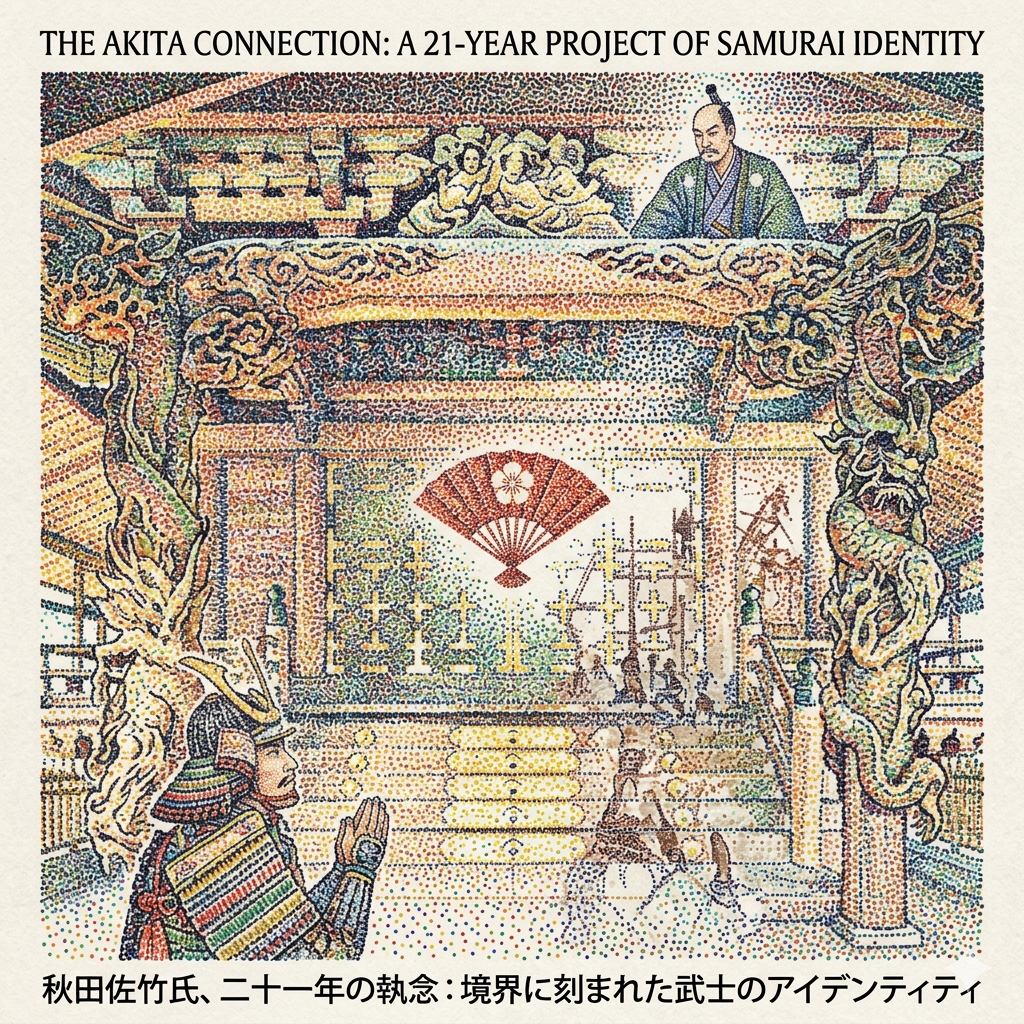
The Dragon Shrine That Took 21 Years to Build: A Dying Feudal Lord's Last Act of Identity
Stand in front of the main hall (honden) of the Ōtori Shrine in Hanabatake and look carefully at the two pillars flanking the entrance. Carved into the zelkova wood are a rising dragon on the left and a descending dragon on the right — attributed to Gotō Yogorō, the thirteenth-generation heir to the lineage of legendary Edo master craftsman Hidari Jingorō.
What most visitors do not know is that this building took twenty-one years to complete, straddling the most violent political transformation in modern Japanese history.
The Satake clan of Akita Domain, based at Kubota Castle in northeastern Japan, claimed descent from Minamoto Yoshimitsu (known as Shinra Saburō), a celebrated late Heian-period general. According to shrine legend, when Yoshimitsu was ordered north to take part in the Later Three-Year War (1083–1087), he stopped at Hanamata Village and prayed before the Washi Daimyōjin for military strength. Upon his victorious return, he donated his battle helmet to the shrine as an offering of gratitude.
Eight centuries later, that ancestral bond remained politically legible. In 1854 — the year Commodore Perry's black ships forced Japan open — the twelfth lord of Akita Domain, Satake Yoshichika, formally commissioned the reconstruction of the shrine's main hall. The building was to be constructed entirely from single-trunk zelkova trees (sōkeyakizukuri), an expensive and technically demanding choice.
The project did not go smoothly. Construction began in 1854. Then came the Ansei Earthquake. Then the Boshin War. Then, in 1871, the abolition of the feudal domain system (haihan chiken), which effectively dismantled the financial and political infrastructure of every major clan in Japan, including the Satake. Funding collapsed. Work halted.
The building was finally completed in 1875 — four years after the Satake ceased to exist as a feudal entity.
What you see when you look at that shrine hall is not simply fine woodwork. It is a family's attempt to inscribe their ancestral legitimacy into a building located in the shogun's own territory, completed just barely before the new Meiji state rendered such acts irrelevant. The shrine's official crest — five-boned fan with a moon circle (gohone-ōgi ni tsukimaru) — is identical to the Satake clan's family emblem. It is, in the most literal sense, a monument to an identity that had to be finished before the world that made it meaningful disappeared.
The main hall was designated a registered cultural property of Adachi Ward in 1982.
See also: our article on Meiji-era shrine architecture in eastern Tokyo and the politics of memory in the Boshin War's aftermath.
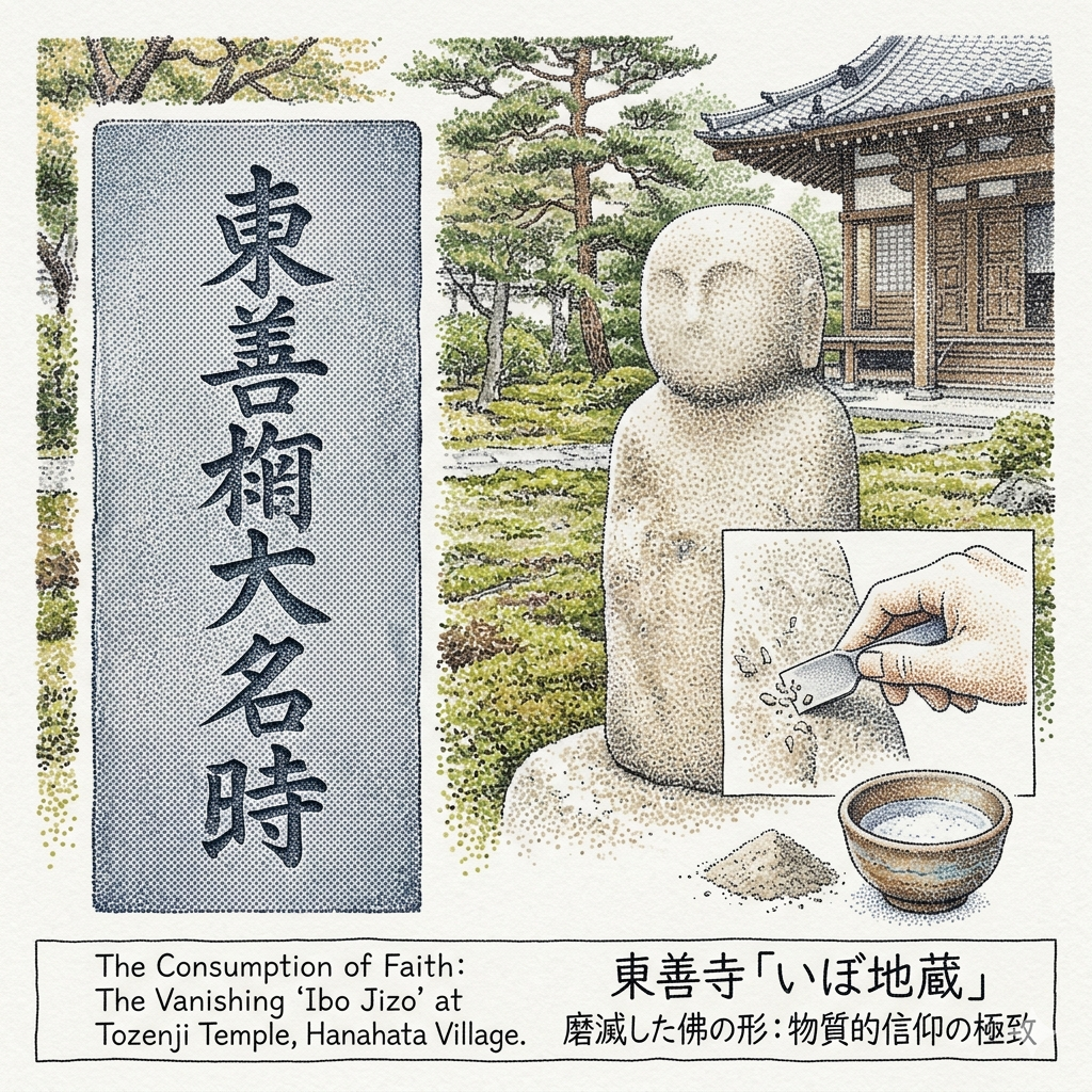
The Buddha That Worshippers Scraped Away: Material Faith at Tōzenji Temple
A few minutes' walk from the Ōtori Shrine stands Tōzenji Temple (東善寺) in Hanabatake 3-chōme — one of only two surviving Jishū sect temples in Adachi Ward. The Jishū sect, founded by Ippen Shōnin, preached universal salvation through the nembutsu (invocation of Amida Buddha), regardless of social status. In the chaos of the Nanbokuchō era (the civil war between rival imperial courts, 1336–1392), Jishū missionaries moved through the river networks of the Kantō plain, establishing temples in isolated wetland communities.
This temple was founded by a priest called San Amidabutsu Shōnin in the mid-fourteenth century. In 1361 — the first year of the Kōan era — he erected a massive stone memorial tablet (itabi), now the oldest documented artifact of its kind in Adachi Ward.
The tablet was carved from chichibu aoshi, a greenish chlorite schist quarried in the Chichibu mountains to the northwest. Delivering a stone of that weight to a low-lying river village required the extensive boat network connecting the Arakawa and Nakagawa river systems. At the top of the tablet, Sanskrit characters representing the Amida Triad. At the center, the six-character nembutsu: Namu Amida Butsu. And clearly inscribed below: the founding history of the temple, the priest's name, the year. This tablet was buried — likely during one of the region's many medieval floods or wars — and only unearthed in 1942, when farmers were clearing a bamboo grove.
It stands in the temple courtyard today as a designated cultural property, clearly legible after more than six and a half centuries.
Nearby stands something harder to explain — and, in its way, more moving.
The temple also houses what is known as the Ibo Jizō (疣地蔵): a stone Jizō Bodhisattva, once carefully carved, once a recognizable figure with robes and a face, now reduced to a featureless, irregular cylinder approximately fifty centimeters tall and equally wide.
It was not vandalism that erased this image. It was faith.
From the early modern period through recent generations, local people believed this particular Jizō had the power to cure warts and skin ailments. The ritual was direct: offer salt to the statue, then use a stone to scrape powder from its surface. Mix the powder with the salt, add water, and apply the paste to the affected skin. Repeat as needed, over years and decades and generations.
The result of that accumulated practice is the object that exists now — a stone from which all distinguishing features have been consumed. The face is gone. The robes are gone. The hands are gone. What remains is the pure residue of ordinary people's physical need and their willingness to act on it.
The absence of the Buddha's form is, paradoxically, the most complete record of the people's faith.
This is not a famous sight. Visitors often mistake the Ibo Jizō for a garden stone. But if you know what you are looking at, it is one of the most quietly astonishing objects in Tokyo.
Tōzenji Temple is located at Hanabatake 3-chōme 20-6, Adachi Ward.
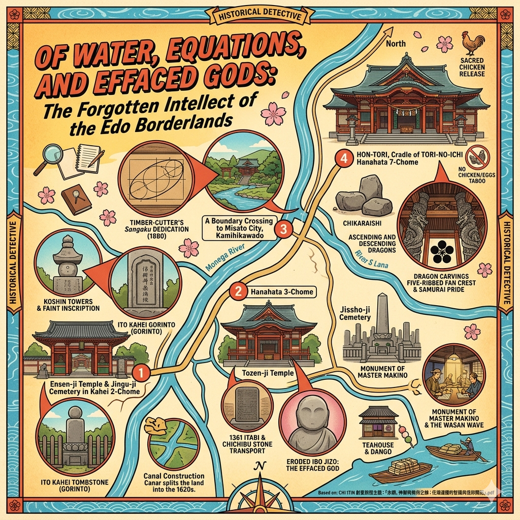
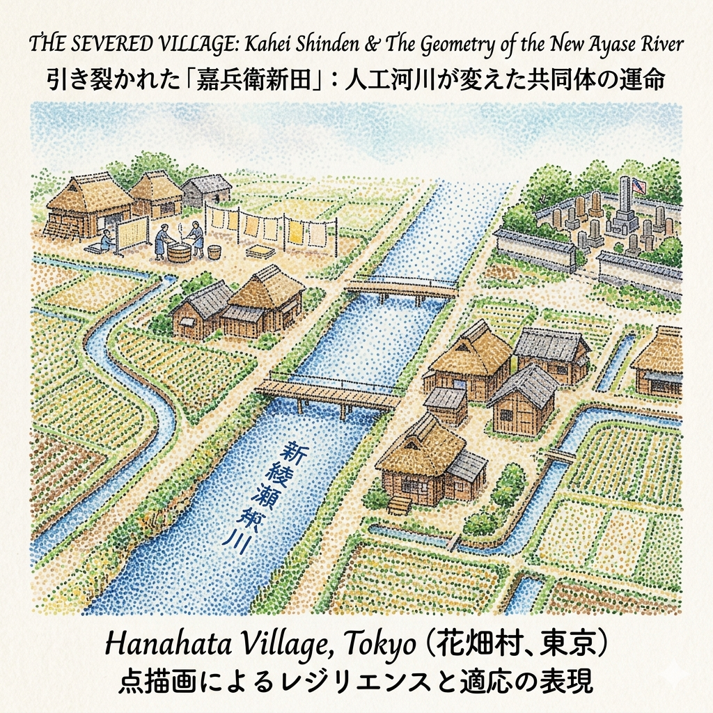
The Canal That Cut a Village in Two: Itō Kahei's Lost Farmland and the Bureaucracy of Memory
In the early seventeenth century, as Tokugawa Ieyasu was consolidating his power in Edo, the shogunate urgently needed to develop the agricultural wetlands to the city's northeast. A farmer from Musashi Province named Itō Kahei led his family north from what is now Kawasaki City to drain a stretch of swampland in Adachi District. The settlement he established was named Kahei Shinden — Kahei's New Fields. It is now the Kahei neighborhood of Adachi Ward.
The reclaimed land ran approximately 870 meters east to west. At its peak, the settlement grew to sixty-five households. But within a generation, the village was cut in two.
To reduce the flood risk to Edo Castle, the shogunate ordered the construction of a new artificial waterway — the Shinkawa, now known as the Shin-Ayasegawa — connecting several points in the Adachi lowlands. The canal was dug straight through the heart of Kahei Shinden, dividing it permanently into eastern and western halves. Each half was subsequently tied to a different irrigation network: the east to the Kasai Canal system, the west to the Minuma Daiyōsui. The two halves of a single farming community had been administratively separated by an act of hydraulic engineering designed to protect a distant city.
The villagers adapted. During winter agricultural downtime, they developed a paper-recycling cottage industry: collecting waste paper from Edo via the river network, processing it into Asakusa-gami (a rough recycled paper), and selling it back to the city. A physical barrier became an economic adaptation.
Kahei himself died in 1633. One hundred and fifty years later, in 1783, his descendants erected a memorial: a five-ringed stupa (gorintō) nearly two meters tall, inscribed with his posthumous Buddhist name and death date. It is among the finest such monuments in the region.
That memorial was displaced again in 1965, when postwar land redistribution and expressway construction forced the relocation of the entire ancestral cemetery to a walled enclosure in the northwest corner of Enzenji Temple's burial ground — the Jingūji Cemetery — where it now stands sealed behind a fence, accessible but separate.
Standing before Kahei's stupa today, one notices another stone immediately adjacent: an 1895 monument to Itō Tomejirō, a third-class naval stoker of the Itō family, killed in the Battle of Weihaiwei during the First Sino-Japanese War. The pioneer ancestor who drained a swamp and the imperial conscript who died in China share the same small walled enclosure. It is a compressed history of what the Meiji state asked of families like this one.
The Itō Kahei tomb (足立区登録有形文化財, 1985) is located at Enzenji Temple, Kahei 2-chōme, Adachi Ward. The Jingūji Cemetery is accessible from the temple's northwestern side.
When the Carpenter Solved the Geometry Problem: Hanabatake's Unlikely Mathematics Culture
In standard accounts of Edo-period rural Japan, commoners appear as the governed: farmers, craftspeople, subjects of samurai administrators and Buddhist temple networks. They are understood to have had functional literacy but not abstract intellectual life.
Hanabatake corrects this misunderstanding with unusual force.
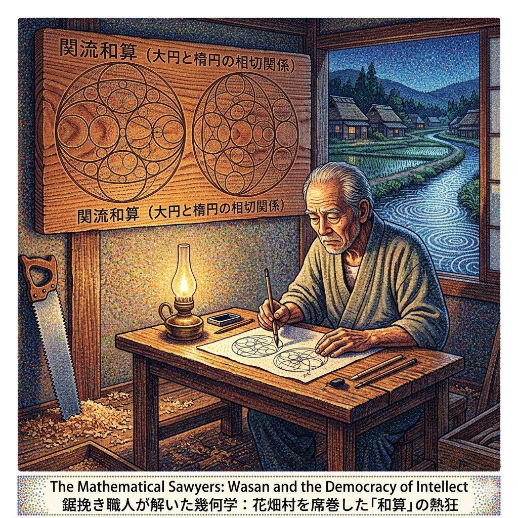
By the late Edo period, the density of terakoya (temple schools) and private academies in the Hanabatake area ranked second in all of Adachi District — surpassed only by the busy post-town of Senju. The area was particularly associated with wasan (和算), the Japanese mathematical tradition that developed sophisticated algebra and geometry entirely independently of Western mathematics. The local reputation was specific enough to generate a saying: "The people of Hanabatake are all skilled at numbers."
The most striking figure to emerge from this culture was Kanasuki Seisaburō Kiyotsune, a resident of Hanamata Village. His day job was kobiki — a sawyer, a manual laborer who cut timber with large frame saws. He was not a priest, not a scholar, not a government official.
Seisaburō became a disciple of Kamiya Sadanori, a leading figure in the Seki-ryū (Seki school) tradition of wasan — the most mathematically rigorous lineage in Japanese mathematics. He mastered advanced algebraic and geometric methods and eventually became qualified to teach others.
In February 1880, at the age of eighty-one, Seisaburō traveled with his student Fukai Ihei Munenori to the Katori Shrine in Misato City (just across the Kegasawa River from Hanabatake) and donated a sangaku — a mathematical votive tablet.
The tablet, cut from a single plank of zelkova wood measuring 40.5 by 56.1 centimeters, presents two geometric problems involving circles inscribed within and tangent to ellipses. Modern wasan scholars have shown that these problems admit more than fifty distinct solution approaches in analytic geometry — problems of a complexity equivalent to advanced Western mathematics of the same era.
The act of donating a sangaku was not merely an intellectual exercise. It was a religious offering: a mathematical proof presented to the gods as a form of devotion, in the same spirit one might offer a poem or a painting. The tablet was hung in the shrine for all to read and attempt.
At Jisshōji Temple in Hanabatake 3-chōme — another anchor of the local mathematics culture — a large stone monument commemorates educator Makino Takayuki, whose private academy trained more than five hundred farm children in advanced mathematics and land surveying. The stone is a designated cultural property of Adachi Ward.
The economic logic behind the wasan culture here was grounded in the landscape: in a low-lying, canal-threaded farming district, precise calculation of irrigation shares, tax assessments, and embankment construction was not a luxury but a survival skill. Over time, however, the culture of mathematical problem-solving exceeded its utility. It became what the research literature describes as a chitekina asobi — an intellectual pastime, a form of beauty, as personally meaningful as composing haiku. To hang a geometrically original problem in a shrine was, for a farmer or a carpenter, a life's honor.
The Kanasuki sangaku remains in the collection of Katori Shrine in Misato City, Saitama Prefecture — a short distance across the Kegasawa River from Hanabatake — and has been designated a significant cultural property of Saitama Prefecture.
For related historical context, see our guide to the Edo-period intellectual landscape of eastern Tokyo and the Seki-ryū wasan tradition.
Hidden Gem Worth Seeking Out
Enzenji Temple's庚申塔 (Kōshin-tō) Group (加平二丁目, Adachi Ward): On the left side of Enzenji Temple's main gate, a row of five Kōshin-tō stone towers stands in quiet alignment. One of them — a kōhai-gata (halo-type) Kōshin tower — bears the name of the temple's twelfth-generation abbot, Danyo Shōnin (died 1733), confirming that Buddhist priests in mid-Edo Adachi were directly integrated into the lay Kōshin confraternity (Kōshin-kō) belief networks. It is an unremarked piece of social history in a neighborhood where most visitors only notice the expressway.
Walking Hanabatake: A Suggested Route
The sites in this article can be connected in a half-day walking circuit of approximately four to five kilometers.
Begin at Hanabatake Ōtori Shrine (Hanabatake 7-chōme) and spend time with the main hall's carved dragons and the chikara-ishi in the precinct. Walk south along residential streets toward Tōzenji Temple (Hanabatake 3-chōme 20-6), where the 1361 stone tablet and the erased Ibo Jizō stand in direct and instructive contrast. Continue to Jisshōji Temple (Hanabatake 3-chōme) for the Makino memorial stone.
From there, cross west across the Shin-Ayasegawa — the canal that bisected Kahei Shinden — and follow the water northward toward Enzenji Temple (Kahei 2-chōme). Enter from the main gate, note the Kōshin-tō group on the left, then find the Jingūji Cemetery at the northwest corner of the grounds. Kahei's stupa and the Itō Tomejirō naval monument are inside.
The walk along the Shin-Ayasegawa is itself worth contemplating. This artificial channel, dug in the 1620s to protect a distant castle, is still here, still running, still the organizing edge of a neighborhood it helped split in two four centuries ago. The river and the expressway above it are, in a sense, the same story told twice.
A Final Reflection: What Peripheral Places Know
Five stories from one small district at the edge of a great city. A sacred chicken taboo that shaped food culture for centuries. A shrine hall that took longer to build than most revolutions last. A Buddha worn smooth by need. A family farm divided by bureaucratic geography. A carpenter who solved problems in elliptic geometry at the age of eighty-one.
None of these fit the standard narratives of Japanese history — the grand periods, the famous battles, the elegant courts. They belong to the margins, which is precisely why they are instructive.
Margins are where states exercise authority experimentally: permitting street gambling in a village they plan to suppress, digging a canal through someone's farmland to protect a city they prefer. Margins are also where people assert their own forms of order — a dietary prohibition that encodes memory, a stone tablet that preserves a name across seven hundred years, a mathematical votive that turns abstract thought into an act of worship.
Hanabatake suggests a question that applies well beyond this neighborhood: what does a place know about itself that its city does not know about it? What remains visible at the edge that disappears at the center?
The answer, in Hanabatake's case, is that ordinary people have always been more intellectually, spiritually, and politically complex than the systems governing them assumed. The dragons on that shrine hall — carved by the last of a lineage, paid for by a clan that no longer existed by the time the work was done — are not a symbol of power. They are a symbol of the effort required to hold on to meaning when everything else is changing.
That effort is worth a half-day in Adachi Ward.
How to Get There
Nearest stations: Hanabatake Station (つくばエクスプレス / Tsukuba Express Line), approximately 8 minutes' walk to the Ōtori Shrine. Alternatively, Kahei Station (Tsukuba Express) for the Enzenji Temple / Jingūji Cemetery cluster.
From central Tokyo: The Tsukuba Express departs from Akihabara Station. Travel time to Hanabatake Station is approximately 23 minutes. The line runs frequently throughout the day.
By bus: Adachi Ward operates heritage walking bus tours covering the Hanabatake area. The seasonal "Adachi's Eight Rivers" bus tour is particularly useful for understanding the water geography described in this article.
Recommended accommodation: For visitors wishing to base themselves in this part of Tokyo, hotels in Kita-Senju (北千住) — served by multiple subway and railway lines — offer convenient access to the Tsukuba Express while keeping you within the broader historical landscape of northeastern Edo. Kita-Senju itself has significant historical layers worth a separate evening walk.
Recommended nearby tours: Several Tokyo historical walking tour operators offer custom itineraries for the Adachi Ward area, including sites covered in this article. Ask specifically for routes that include the Shin-Ayasegawa canal corridor, the Ōtori Shrine precinct, and the Tōzenji Temple compound. Pre-booking is advisable for groups.
If you found this article useful, consider subscribing to the Historical Travel Stories newsletter — we publish two deep-dive historical travel guides each month, focusing on places that reward careful attention rather than quick visits.
Q & A
Why did ordinary villagers in Hanahata become experts in advanced mathematics?
Ordinary villagers in Hanahata (historically Hanamata) became experts in advanced mathematics—specifically Wasan (traditional Japanese mathematics)—due to a unique intersection of geographical necessity, high educational density, and a cultural shift that transformed mathematics into a popular intellectual pursuit.The primary factors contributing to this "Wasan boom" included:
- Practical Economic and Engineering Needs: Hanahata was situated in a low-lying marshland with a complex network of rivers and irrigation systems. Farmers required precise calculation and surveying skills for daily survival and economic management, such as:
- Allocating irrigation water shares from the "Kasai Irrigation" system.
- Constructing and maintaining dams and water infrastructure.
- Calculating rice taxes (known as Nozeni).
- High Density of Educational Institutions: During the late Edo and early Meiji periods, Hanahata boasted a remarkable concentration of temple schools (tera-koya) and private academies (shijuku). Its educational density was the second highest in the Adachi District, surpassed only by the major transport hub of Senju-shuku. One specific academy, the "Makino Takayuki Juku," trained over 500 students from farming backgrounds in advanced mathematics and surveying techniques.
- Cultural Evolution into an "Intellectual Game": Over time, the study of mathematics transcended its practical roots and evolved into a high-level hobby or "intellectual game" similar to composing haiku. Villagers viewed the creation and dedication of sangaku (mathematical votive tablets) at shrines as a great honor and a lifelong achievement.
- Democratization of Knowledge: The sources highlight that advanced academic knowledge was not restricted to the elite class. Kanasugi Seizaburo, a local resident and sawyer (woodworker), became a master of the Seki school of Wasan. Despite his background in physical labor, he mastered complex algebra and geometry, eventually teaching his own students and dedicating a sangaku in 1880 that featured advanced geometric problems involving tangent circles and ellipses—problems that equate to modern high-level analytical geometry.
This grassroots passion for mathematics meant that by the late 19th century, it was said that "the people of Hanahata are all skilled in math." This widespread intellectual foundation later served as the hidden intellectual basis for Japan’s rapid absorption of Western science and technology during the Meiji Restoration.
Why did people scrape dust off the Ibo Jizo statue?
People scraped dust (stone powder) off the Ibo Jizo (Wart Jizo) statue at Tozen-ji Temple because of a deeply held local belief in its miraculous healing powers for skin conditions,.According to the sources, the practice followed a specific ritual motivated by practical and spiritual needs:
- Wart Removal: Commoners believed that the statue possessed the divine power to clear away skin warts (ibo).
- The Ritual Process: To seek a cure, a person would first offer salt to the Jizo. They would then use a stone tool to scrape powder directly from the body of the statue.
- Creation of a "Medicine": The seeker would mix this scraped stone powder with the offered salt and water to create a paste, which they would then apply to their warts.
This practice was a form of "material faith," where the Buddhist statue was not merely a symbol to be worshipped from a distance, but was treated as a physical source of medicine to be consumed. Because this ritual was performed by countless people over several centuries, the physical features of the Jizo—including its face, robes, and hands—were eventually completely worn away. Today, the statue has been transformed into a featureless, unshaped stone cylinder roughly 50 centimeters tall, serving as a physical testament to the intense faith of the local people.
Reference and Further reading
- 花畑村 - accessed June 1, 2026,
- 花畑大鳥神社 | 東京都足立区 | 古今御朱印研究所, accessed June 1, 2026,
- 葛飾区史|第5章 暮らしの移り変わり, accessed June 1, 2026,
- 花畑運河 - accessed June 1, 2026,
- 綾瀬川の歴史・文化 | 江戸川河川事務所 - 関東地方整備局, accessed June 1, 2026,
- 花畑地区 - 足立区, accessed June 1, 2026,
- 東善寺|足立区花畑にある時宗寺院 - 猫の足あと, accessed June 1, 2026,
- 歴史探訪と温泉: 円泉寺/伊藤嘉兵衛の墓(加平), accessed June 1, 2026,
- 祭事・行事 - 大鷲神社, accessed June 1, 2026,
- 花畑大鷲神社 / 東京都足立区 | 御朱印・神社メモ, accessed June 1, 2026,
- 【酉の市発祥の地】足立区の花畑大鷲神社をご紹介します! | ハウスセイラーズブログ, accessed June 1, 2026,
- 境内案内図 - 大鷲神社, accessed June 1, 2026,
- 大鷲神社 (足立区) - accessed June 1, 2026,
- 東善寺 | あだち観光ネット - 足立区観光交流協会, accessed June 1, 2026,
- 板碑(いたび) - 足立区, accessed June 1, 2026,
- 東善寺 (足立区) - accessed June 1, 2026,
- 江戸旧蹟を歩く 新田開発, accessed June 1, 2026,
- いかに地域に貢献可能か ――「あだち学」検討プロジェクト, accessed June 1, 2026,
- 日本橋福徳神社の算額について, accessed June 1, 2026,
- 金杉清常(かなすぎ せいじょう)とは? 意味や使い方 - コトバンク, accessed June 1, 2026,
- 足立区花畑に花畑はなかった - デイリーポータルZ, accessed June 1, 2026,
- 歩こうあだち〈花畑編〉 "歩きたくなる街・歴史散歩で静を感じる街” - はなはた - 足立区観光交流協会, accessed June 1, 2026,
- 酉の市(由来と歴史), accessed June 1, 2026,
- 酉の市③ 大鷲神社/鷲神社 - 歴史探訪と温泉 - FC2, accessed June 1, 2026,
- 東京・足立・大鷲神社 – 日本の美しい色風景 - 日本色彩学会, accessed June 1, 2026,
- 花畑 大鷲神社, accessed June 1, 2026,
- 花又村(はなまたむら)とは? 意味や使い方 - コトバンク, accessed June 1, 2026,
- 庚申信仰の板碑と庚申塔, accessed June 1, 2026,
- 加平 - accessed June 1, 2026,
- 新田開発 - 歴史探訪と温泉 - FC2, accessed June 1, 2026,
- 加平天祖神社 - 歴史探訪と温泉 - FC2, accessed June 1, 2026,
- 円泉寺|足立区加平にある浄土宗寺院 - 猫の足あと, accessed June 1, 2026,
- 算額, accessed June 1, 2026,
- 足立区の8つの川をめぐるバスツアー, accessed June 1, 2026