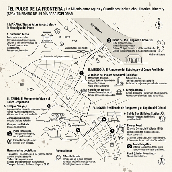
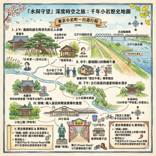
(ENG) “Koiwa Historical Walk – 5 Layers of Resilience on Tokyo’s Edogawa Border”
Walk through the temporal layers of Koiwa, from 8th-century administrative experiments to the bustling post-war Flower Road. Discover how the Edogawa River shaped this resilient community through stories of samurai barriers, poetic water-gardens, and the legendary 600-year-old Yogo-no-matsu pine.

This is a historical travel story and walking guide to Koiwa, a unique neighborhood on the eastern edge of Tokyo. Through five historical layers, it explores ancient census records, Edo-period river barriers, and post-war commercial growth to reveal how this riverside community reshaped its soul against administrative orders and natural forces. Readers will discover a hidden side of Tokyo’s Shitamachi through ancient shrines, legendary pine trees, and artisan legacies.
The Borderland Identity
To the unobservant eye, Koiwa may seem like a mere punctuation mark on the JR Sobu Line—a blur of grey concrete before the train crosses the Edogawa into Chiba. Yet, for the cultural geographer, this neighborhood is a profound "spatial specimen," a living archive of Tokyo’s eastern threshold that has been continuously inhabited for over thirteen centuries. Koiwa has always existed at the intersection of "borderlines" and "water veins," a landscape where the fluid unpredictability of the river delta meets the rigid administrative desires of the state. For those seeking a [comprehensive Tokyo historical travel guide], Koiwa offers a rare verticality of history; here, the past is not buried, but physically felt in the subtle rise of a street or the ancient lean of a pine. To walk these streets is to trace a 1,300-year journey from the mud of a Nara-period frontier to the gritty resilience of a post-war trade hub.
Listen to the historical stories told in detail (For subscribers only)
The Ghost of Kowa-ri: Administrative Ambition in the Marshlands
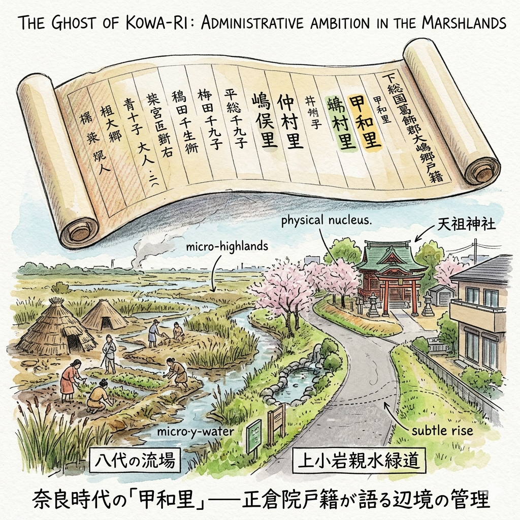
In the 8th century, the Yamato Court sought to tame the wild eastern frontiers through the Ritsuryo system, an early form of centralized bureaucracy. This transition from local clan rule to imperial governance required a sophisticated tool of "information technology": the census. By recording the population, the state sought to convert a fluid marshland into a taxable, ordered territory.
The 702 AD census, miraculously preserved in the Shosoin Repository in Nara, serves as a "social encoding" of this landscape. In these records, the area appears as "Kowa-ri," one of three administrative units—alongside Nakamura and Shibamata—that comprised the Oshima Township. This was an act of high-stakes mapping; the imperial desire for order was imposed upon a water-logged reality. Archaeological excavations at the Kamikoiwa ruins reveal that Nara-period residents clung to "micro-highlands"—slight elevations in the river delta that are still detectable today as a subtle rise in the asphalt. This tension between the state’s tidy paperwork and the residents’ muddy struggle for survival on these tiny islands of dry land defined Koiwa’s earliest identity.
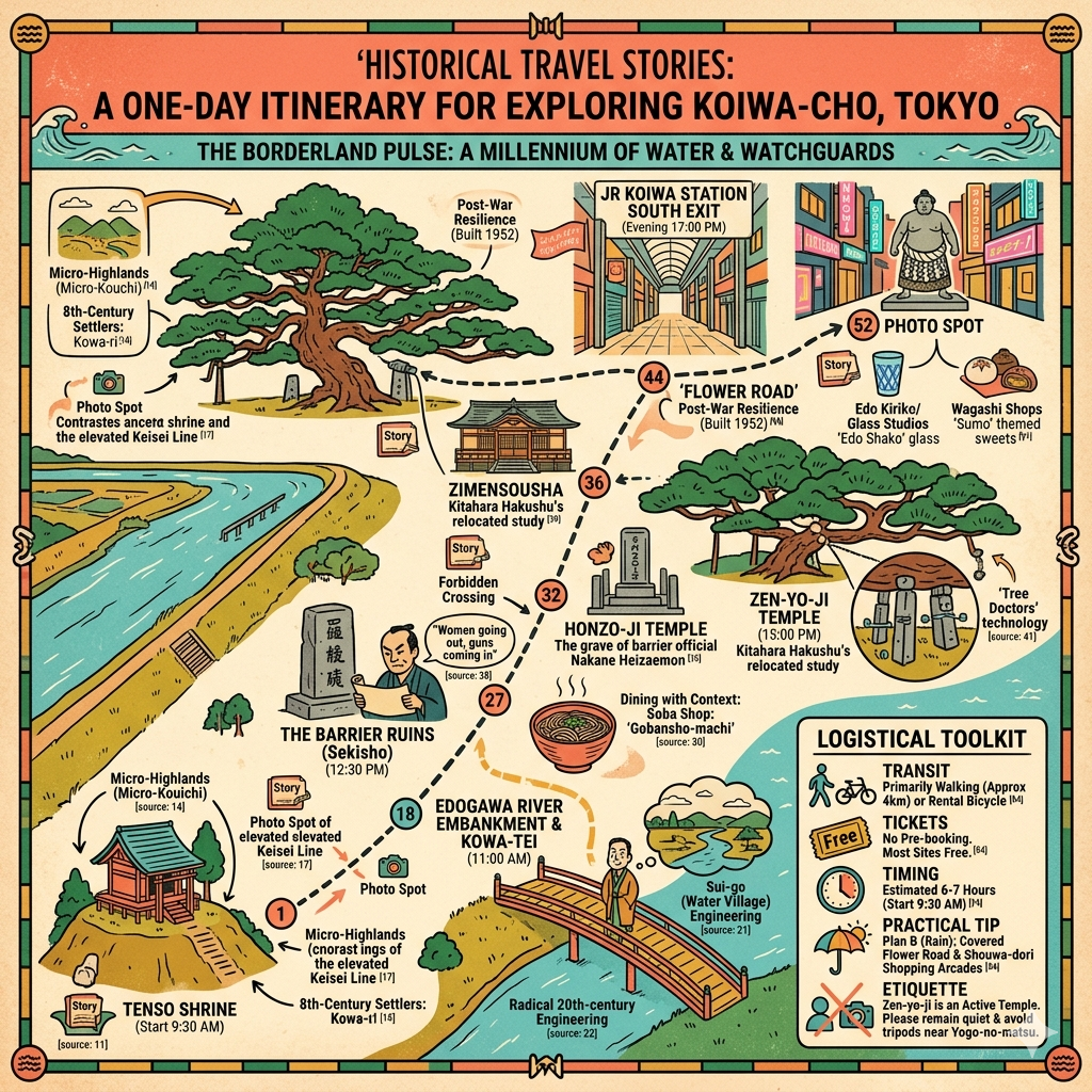
Today, the Kamikoiwa Shinsui Ryokudo (Greenway) follows the path of these ancient waterways, leading to the Tenso Shrine, the physical nucleus of that original high-ground settlement. Nearby, the Kowa-tei building serves as a linguistic bridge, preserving a name that first entered the written record 1,300 years ago.
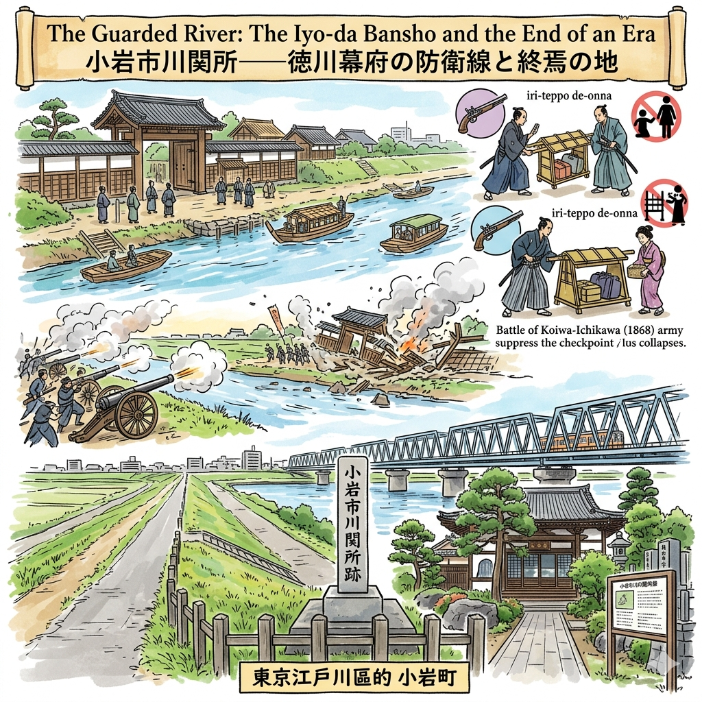
The Guarded River: The Iyo-da Bansho and the End of an Era
Under the Tokugawa Shogunate, the Edogawa was weaponized. To defend the capital, the Shogunate enforced a "No Bridge" policy, turning the river into a mandatory bottleneck. Koiwa became the site of the Iyo-da Bansho (also known as the Ichikawa Checkpoint), one of the five major gates into Edo. It was here that the Shogunate enforced its most famous spatial taboo: iri-teppo de-onna (incoming guns and outgoing women). This policy ensured that no weapons entered the city and no hostages—the families of regional lords—fled it.
This guarded status remained unchallenged until 1868. During the Battle of Koiwa-Ichikawa, the checkpoint became the tactical pivot between the retreating Shogunate forces and the New Government army. This was more than a military skirmish; it was the moment the "spatial taboos" of the Edo period collapsed under the pressure of modern warfare. When the New Government’s superior artillery suppressed the checkpoint from the western bank, the centuries-old prohibition against bridges and free movement was effectively shattered.
The Koiwa Ichikawa Sekisho-ato monument now stands on the Edogawa embankment, marking where the old order fell. A short walk away, Honzo-ji Temple houses the graves of the Nakane family, the hereditary checkpoint officials. This area remains one of the most significant [neighborhoods of the Edo-period Edogawa river], where the streets still follow the defensive layout of the old "guard town."
The Poetry of Displacement: Kitahara Hakushu and the Great Floodway
By the early 20th century, Koiwa had become a romantic, literary escape. The landscape was a mosaic of reeds and "shifting light" (流動的雲影)—an aesthetic that drew the famous poet Kitahara Hakushu to the area in 1916. He named his retreat the Shien Kousha (Purple Smoke Hut), immortalizing the water-country atmosphere in his verse.
However, this poetic landscape was fundamentally incompatible with modern urban safety. Following the 1910 Great Flood, which devastated the region, the government initiated the Edogawa Floodway project—a "surgical" engineering feat designed to protect Tokyo at any cost.
"The 1910 flood was a national catastrophe; the damage to homes and infrastructure was so immense that the resulting losses accounted for roughly 1.7% of Japan’s total national income at the time."
The creation of the floodway required the "creative destruction" of the landscape Hakushu loved. Massive embankments were raised, and the Purple Smoke Hut was moved three times to make way for the excavators. Saving the city meant erasing the poet’s riverbank. Today, the reconstructed Shien Kousha sits within the grounds of Zanyo-ji Temple, a quiet reminder of a lost geography. The current riverbanks, though vast and beautiful, are monuments to this modern triumph of infrastructure over aesthetics.

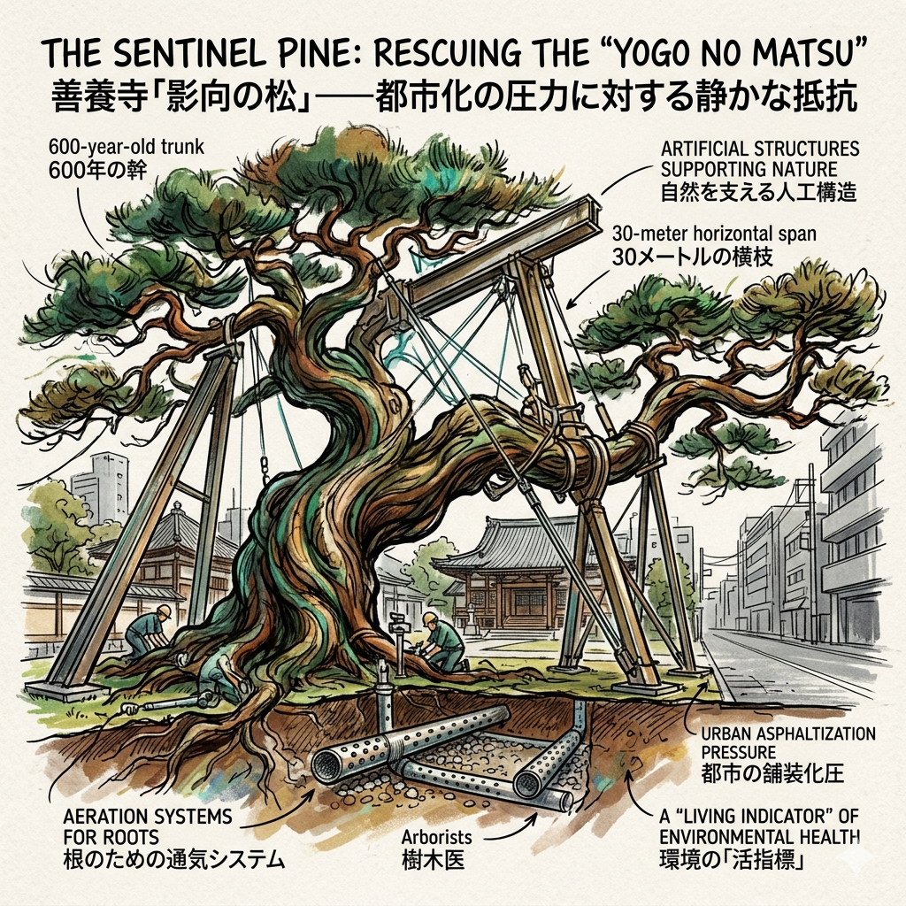
The Sentinel Pine: Rescuing the "Yogo no Matsu"
Amidst these layers of destruction stands a singular survivor: the Yogo no Matsu. This 600-year-old pine tree at Zanyo-ji has witnessed every era of Koiwa’s history. However, its greatest threat was not the river or war, but the "asphaltization" of the 20th century. As Koiwa urbanized, the hardened soil and air pollution began to choke the ancient tree.
The intervention that followed represents a shift in our relationship with the land—from conquering nature to high-tech ecological restoration. "Tree doctors" (arborists) performed precision surgery, installing aeration systems in the roots. Standing beneath the tree’s 30-meter horizontal span today, one sees a remarkable symbiosis: the ancient, twisting wood is supported by a complex network of artificial structures. The tree is a "living indicator" (活指標) of environmental health—a natural monument maintained by the very technology that once threatened it.
Glass and Grit: From Artisan Enclaves to Jizo-dori
As Tokyo industrialized, the glassmaking industry migrated to Koiwa, drawn by the water and lower land prices. When the 1945 air raids leveled much of central Tokyo, Koiwa miraculously survived. This survival dictated its post-war destiny as a trade hub.
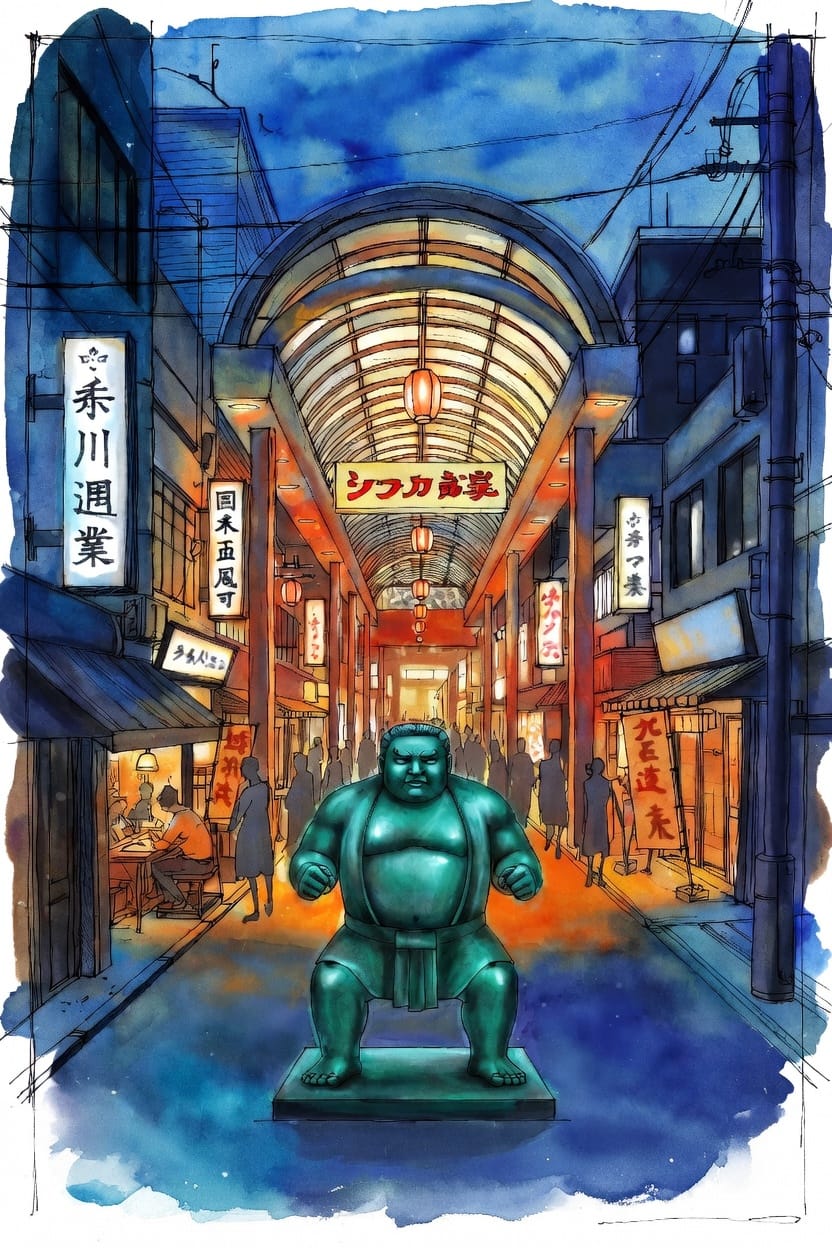
Because its infrastructure remained standing, the area near the South Exit, specifically Jizo-dori, became a thriving Yami-ichi (black market). This "marginal space" advantage allowed Koiwa to transition rapidly from a production center for Edo Kiriko (carved glass) to a commercial powerhouse. This grit eventually evolved into the Flower Road arcade, which in 1952 became the very first covered shopping street in Edogawa City.
At the station, the bronze statue of the legendary Sumo wrestler Tochinishiki—a local hero—stands as a symbol of this neighborhood’s resilience.
Visit the local glass workshops tucked into the alleys of South Koiwa, where the centuries-old tradition of Edo Kiriko is still practiced by independent artisans.
Conclusion: The Layered Observation of a Border Town
Koiwa is not a "tourist destination" in the conventional sense; it is a 文明斷層錄 (Chronicle of Civilization’s Fault Lines). From the 8th-century census to the post-war hustle of Jizo-dori, every layer of its history reveals a tension between the state’s need for order and the individual’s need to build a home. The "fault lines" of history here are inhabited by people—from the artisans practicing Edo Kiriko to the legacy of Tochinishiki. As you walk the embankments, consider how the very ground reflects the tension between the state's need for order and the individual's need for home.
To explore more of Tokyo's hidden geographies, subscribe to our weekly dispatches.
Traveler’s Appendix
- How to Get There: Take the JR Sobu Line to Koiwa Station or the Keisei Line to Keisei Koiwa. Please note that the two stations are approximately a 15-minute walk apart, representing the different North and South "layers" of the district.
- Recommended Walking Route: Begin at Zanyo-ji Temple to see the Yogo no Matsu and the Purple Smoke Hut. Walk along the Edogawa embankment to the Ichikawa Checkpoint site, then head south through the historic "guard town" alleys of North Koiwa to conclude your journey at the Flower Road shopping arcade.
- Nearby Interest: Consider a Traditional Crafts Tour in South Koiwa, focusing on the surviving glass workshops that continue the legacy of Edo Kiriko.
Q & A
How did water governance shape Koiwa's identity over 1,300 years?
Water governance has been the primary architect of Koiwa’s identity for over 1,300 years, transforming it from a fragile borderland settlement into a strategic gateway and, finally, a controlled modern urban space. This evolution is characterized by a shift from administrative infiltration to defensive restriction and, eventually, large-scale engineering.
1. Ancient Administrative Infiltration (Nara Period)The earliest identity of Koiwa, known as "Kowa-ri," was defined by the state's attempt to control a volatile water-rich environment.
- Social Encoding: In 702 AD, the Yamato Court used detailed census records (preserved in the Shosoin) to stabilize the fluid population living in the river delta.
- Geographic Adaptation: Residents lived on micro-highlands (such as the Upper Koiwa site) to survive frequent flooding. The very name "Kowa" likely relates to the "bend of the river," establishing the area's identity as a strategic water junction managed through early "information technology" (paper records).
2. Strategic Immobility and Defense (Edo Period)During the Tokugawa Shogunate, water governance took the form of enforced disconnection to protect the capital.
- The "No Bridge" Policy: To secure Edo (Tokyo), the Shogunate prohibited building bridges over the Edo River. This forced all travelers and daimyo to rely on ferries at the Koiwa-Ichikawa Checkpoint.
- Gateway Identity: Koiwa became an "official checkpoint town" (Gomansho-machi), acting as a physical and administrative sieve that controlled the flow of people and weapons into the capital.
3. The "Conquest of Nature" (Meiji and Taisho Eras)The devastating Great Kanto Flood of 1910 triggered a paradigm shift from "coexisting with water" to "natural conquest" through massive infrastructure.
- The Discharge Channel: The construction of the Edo River Discharge Channel (starting in 1919) was a "surgical" transformation of the landscape. It permanently severed the community's intimate connection with the natural riverbanks.
- Erosion of Literary Identity: This engineering destroyed the "water village" aesthetic that had attracted poets like Kitahara Hakushu. The landscape became a defensive engineering project, prioritized for public safety over cultural preservation.
4. Modern Environmental Stewardship and ResilienceIn the late 20th century, water governance evolved again to address the ecological feedback of rapid urbanization.
- Biological Survival: The 600-year-old "Yogo-no-matsu" pine tree at Zenyo-ji became a symbol of this era. When urbanization and asphalt roads disrupted groundwater flow, leading to the tree's decay, a decades-long rescue effort by "Tree Doctors" began.
- Controlled Balance: Today, the tree and the Upper Koiwa Hydro-Greenway (built on ancient water routes) represent a modern identity of "controlled balance"—an attempt to reconcile urban safety with the preservation of the area's "water soul".
In summary, water governance has shifted Koiwa's role from a fragmented border to a strategic moat, and finally to a resilient urban hub where the community continues to negotiate its survival against the very river that defined its birth.
How did Koiwa transition from a border checkpoint to commerce?
The transition of Koiwa from a strategic border checkpoint to a thriving commercial hub was driven by the collapse of feudal restrictions, the arrival of modern rail infrastructure, and a remarkable display of local resilience following World War II.According to the sources, this evolution occurred in three primary stages:
1. The Shifting Gateway (Edo Period to Meiji Restoration)During the Edo period, Koiwa’s identity was defined by the Koiwa-Ichikawa Checkpoint, a critical security node for the Tokugawa Shogunate,.
- Enforced Stagnation: Because bridges were prohibited for defense, all travelers and goods were forced to use ferries, creating a natural concentration of people in the "checkpoint town" (Gomansho-machi),.
- The Turning Point (1868): The Boshin War transformed the checkpoint into a battlefield. The victory of the new government forces led to the abolition of the checkpoint, signaling the end of "spatial taboos" like the ban on bridges and the beginning of Koiwa’s transformation into an open transit point.
2. Industrial Infiltration and Rail Connectivity (Late 19th Century)The late 19th century saw Koiwa transition from a rural borderland to an industrializing suburb.
- Arrival of the Railway: The opening of Koiwa Station in 1899 (Sobu Railway) was a catalyst, establishing the area as a major transportation hub and attracting new residents and businesses,.
- The Glass Industry: Between the late 19th and early 20th centuries, glass manufacturers (producers of Edo Kiriko) migrated from central Tokyo to Koiwa, attracted by lower land prices and the abundant water supply needed for production,. This established a "maker culture" that underpinned the local economy.
3. Post-War Commercial Resilience and the "Black Market"The most significant leap toward modern commerce occurred after 1945 due to a combination of geographic luck and organized local effort.
- Survival from Air Raids: Koiwa miraculously escaped the widespread fire damage of the 1945 Tokyo Air Raids, leaving its physical buildings and infrastructure intact while much of central Tokyo was leveled.
- The Black Market (Yami-ichi): Because the physical space remained, the south exit of Koiwa Station became a massive black market in the chaotic post-war years, rapidly evolving into a permanent shopping district,.
- Commercial Innovation: Koiwa’s merchants were among the first to organize, forming a shopkeepers' association as early as 1947. In 1952, they constructed "Flower Road," the first covered arcade in Edogawa Ward, solidifying Koiwa’s reputation as a premier commercial destination,.
In summary, the transition was a move from a "broken boundary" that restricted flow to a "flowing gateway" that harnessed it. The area utilized its status as a transportation hub to first absorb displaced industries like glass making and later to capitalize on its surviving infrastructure to lead the post-war retail boom.
Reference and Further reading
- 江戸川区郷土資料室に歴史資料を見に行ってきました, accessed April 12, 2026,
- 小岩の歴史とゆかりの人物を巡るコース - 江戸川区, accessed April 12, 2026,
- 指定のページは見つかりませんでした-accessed January 1, 1970,
- 郷土資料室 江戸川区ホームページ, accessed April 12, 2026,
- 江戸川区郷土資料室 | 美術館・博物館 | アイエム[インターネットミュージアム], accessed April 12, 2026,
- 小岩・市川関所と御番所町 - 歴史探訪と温泉, accessed April 12, 2026,
- 御番所町跡 江戸川区 文化財・史跡, accessed April 12, 2026,
- 小岩地区の紹介 - 江戸川区, accessed April 12, 2026,
- 小岩市川関所 - accessed April 12, 2026,
- 旧千葉街道, accessed April 12, 2026,
- 江戸川区郷土資料室 / 資料館 / 松島 / 新小岩駅, accessed April 12, 2026,
- 北小岩の名所旧蹟めぐり - myluxurynight.com, accessed April 12, 2026,
- 荒川放水路変遷誌[PDF - 関東地方整備局, accessed April 12, 2026,
- 5 むかしのようす(建設の経過) - 自然博物館サイト(江戸川放水路) - 市川市, accessed April 12, 2026,
- 2.3.3.4 中川放水路(新中川)開削, accessed April 12, 2026,
- 5 小岩地域 - 江戸川区, accessed April 12, 2026,
- 史跡等の指定等について, accessed April 12, 2026,
- 国土技術政策総合研究所資料 - 国総研, accessed April 12, 2026,
- 江戸硝子とは。江戸に花開いた和硝子の歴史と現在 | 中川政七商店の読みもの, accessed April 12, 2026,
- 江戸切子とは|歴史・代表的文様・製作工程・定義・指定|江戸切子 ..., accessed April 12, 2026,
- 小岩 戦災を免れた地に形成された闇市の跡, accessed April 12, 2026,
- 商店街の歴史 - フラワーロード・JR小岩駅南口アーケード美観商店街, accessed April 12, 2026,
- 新小岩・小岩の観光スポット クチコミ人気ランキングTOP20【フォートラベル】, accessed April 12, 2026,
- 伝統工芸品 江戸切子 - 江戸川区, accessed April 12, 2026,
- 江戸切子 | 東京の伝統工芸品 | 東京都産業労働局, accessed April 12, 2026,
- 小岩駅・京成小岩駅――江戸川の流れと共に…"100年栄えるまちづくり"(東京都江戸川区/JR中央・総武線各駅停車・京成本線)①歴史編 - マンション図書館, accessed April 12, 2026