(ENG) Oshima Island Historical Walk – Volcano Worship and Exile Stories on Tokyo’s Volcanic Isle
Venture beyond Tokyo to Izu Oshima, where active volcanoes meet centuries of exile history. This guide takes you on a historical walk through the island's mystical landscapes and resilient culture.

This is a historical travel story and walking guide to Izu Oshima, a volcanic island near Tokyo. Through the lens of Mount Mihara’s geological power and ancient tales of exile, it explores the island's unique relationship with nature, religious rituals, and its past as a place of banishment. Readers will discover a slow-travel route that connects breathtaking landscapes with the deep cultural memory of the Japanese archipelago.
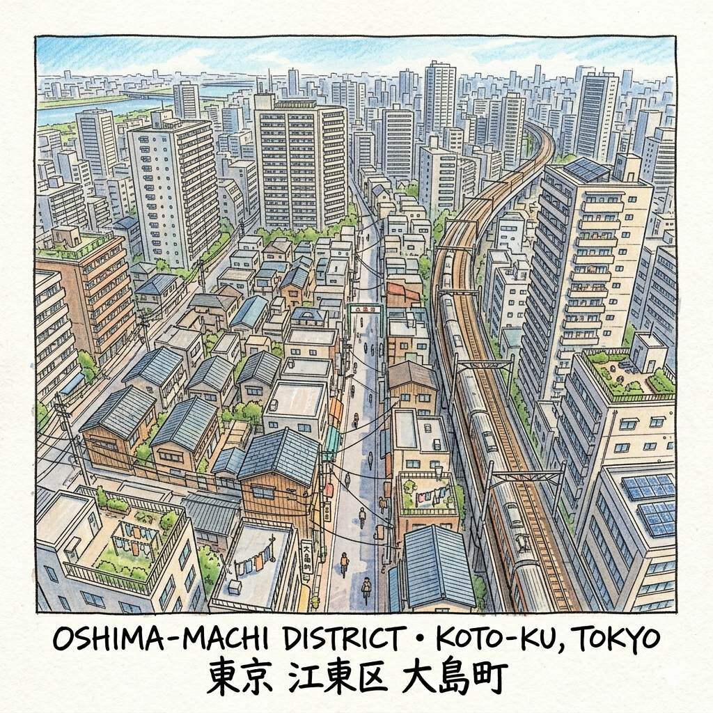
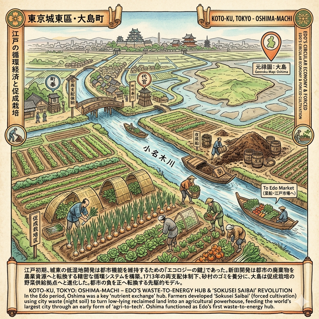
The district of Oshima, nestled within the low-lying basin of modern-day Koto-ku, represents one of Tokyo’s most profound historical experiments in urban engineering and strategic survival. Originally a mosaic of tidal flats and shifting sandbars at the edge of Tokyo Bay, this landscape was systematically reclaimed starting in the mid-17th century. It was never merely a residential overflow; for the Tokugawa Shogunate, Oshima was a vital frontier—a laboratory for resource management where the city’s waste was transformed into agricultural vitality. Today, the canal-side paths of the Onagi River offer a meditative gateway into this past. As you walk these banks, the geometry of the water still dictates the rhythm of the neighborhood, inviting the visitor to feel the weight of a landscape designed for utility yet defined by the complex, shifting layers of human ambition and environmental consequence.
The "So What?" Layer: To walk through Oshima is to witness the physical manifestation of an urban survival strategy that turned a "worthless" swamp into the city's essential heartland. By viewing Oshima as a historical experiment rather than a modern residential block, we begin to understand how Tokyo’s very existence depended on this peripheral land. We invite you to peel back the modern pavement and explore five specific layers of time that define this enduring landscape.
Listen to the historical stories told in detail (For subscribers only)
The Edo Circular Economy and the "Sokusei Saibai" Revolution
During the Edo period, Oshima was the linchpin of a sophisticated "nutrient exchange" system. In 1681, the nearby Sunamura was designated as a primary waste site; the resulting humus, combined with "night soil" (human waste) collected from the million-person city, turned Oshima’s reclaimed soil into an agricultural powerhouse. This led to the development of Sokusei Saibai (forced cultivation), a revolutionary technique that allowed farmers to harvest vegetables earlier than elsewhere in Japan. This gave Oshima’s growers a critical competitive advantage in the urban markets, effectively feeding the world's largest city through an early form of "agri-tech."
Administratively, the area operated under the Ryoshihai (Two-Rule) system. This meant management was shared between the Machibugyo (City Administrators) and the Daikan (Shogunal Deputies), reflecting Oshima's unique dual identity as both a commercial extension of the town and a productive rural village.
Administrative Evolution Milestones (1644–1900):
Period | Status/Event | Administrative Change |
1644–1647 | Initial Reclamation | Coastal lowlands are systematically filled to create "New Fields." |
1706 | Official "Town" Status | Deepagawa (Fukagawa) Upper and Lower Oshima-cho are established. |
1713 | Two-Rule Implementation | Joint administration by City Administrators and Shogunal Deputies begins. |
1878 | Fukagawa Incorporation | Formally integrated into the Fukagawa District during early Meiji reforms. |
1900 | Oshima-machi Formation | Oshima Village is officially elevated to the status of a Town. |
"The name 'Oshima' (Big Island) first appears prominently in the '元祿圖' (Genroku Map) circa 250 years ago, so named because its landmass was significantly larger than the surrounding minor sandbars and tidal flats."
The "So What?" Layer: Oshima functioned as Edo’s first "waste-to-energy" hub. By integrating urban sanitation with high-output agriculture, the Shogunate created a sustainable loop that powered the city. This success, however, would later set the stage for Oshima’s transition from organic waste to industrial chemistry.
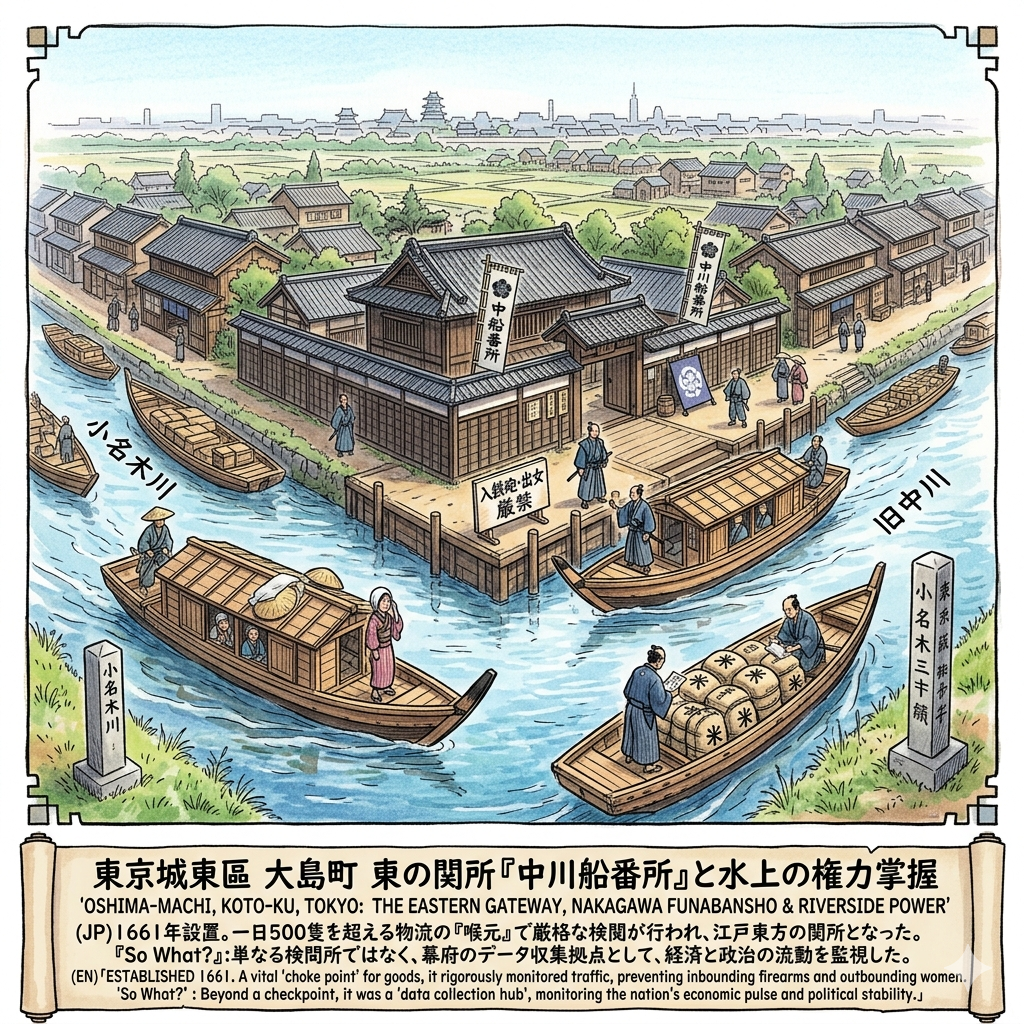
The Eastern Gateway: Control and the "Nakagawa Funabansho"
As water was the lifeblood of Edo’s logistics, the Shogunate required a rigorous "choke point" to monitor the flow of goods and people. In 1661 (the first year of the Kanbun era), the Boat Guard House was moved to the strategic junction of the Onagi River and the Kyu-Nakagawa, becoming the Nakagawa Funabansho—the "Eastern Gate of Edo."
Nakagawa Control Regulations:
Regulation | Objective & Historical Context |
Night Navigation Ban | Strictly prohibited boats from entering or leaving Edo at night to maintain security. |
Identity Verification | Passengers were required to remove hats and head-covers for facial inspection by officials. |
"Inbound Weapons, Outbound Women" | A doctrine to prevent illegal arms from entering the capital and to stop the wives of daimyo (shogunal hostages) from escaping to their home provinces. |
Special Permits | Required for the transport of wounded persons, prisoners, or corpses to prevent the smuggling of fugitives. |
The "So What?" Layer: The Funabansho transformed Oshima into a critical node of data and security. It was here that the Shogunate monitored the pulse of the nation’s economy and political stability, collecting vital intelligence on the movement of every traveler and every sack of rice entering the capital.
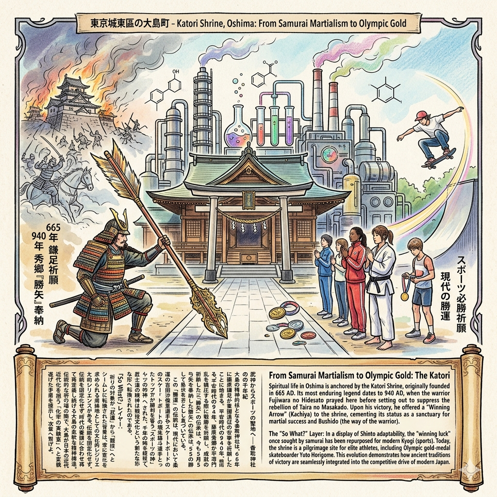
From Samurai Martialism to Olympic Gold: The Katori Shrine
Spiritual life in Oshima is anchored by the Katori Shrine, originally founded in 665 AD. Its most enduring legend dates to 940 AD, when the warrior Fujiwara no Hidesato prayed here before setting out to suppress the rebellion of Taira no Masakado. Upon his victory, he offered a "Winning Arrow" (Kachiya) to the shrine, cementing its status as a sanctuary for martial success and Bushido (the way of the warrior).
The "So What?" Layer: In a display of Shinto adaptability, the "winning luck" once sought by samurai has been repurposed for modern Kyogi (sports). Today, the shrine is a pilgrimage site for elite athletes, including Olympic gold-medal skateboarder Yuto Horigome. This evolution demonstrates how ancient traditions of victory are seamlessly integrated into the competitive drive of modern Japan.
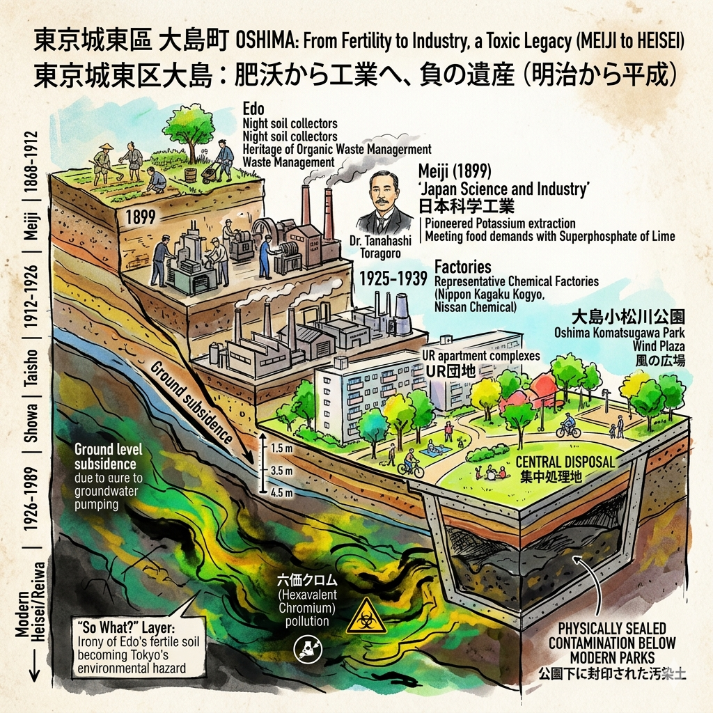
The Laboratory of Modernity: Fertilizers and Their Toxic Legacy
In the Meiji era, Oshima’s heritage of organic waste management took a darker, industrial turn. In 1899, Dr. Tanahashi Toragoro established "Japan Science and Industry," pioneering the extraction of potassium from tobacco waste. The district rapidly became the heart of Japan's chemical industry, replacing humus with superphosphate of lime to meet the food demands of a modernizing nation.
Representative Chemical Factories (1925–1939):
Factory Name | Primary Products |
Japan Science and Industry | Potassium and iodine fertilizers |
Nitto Chemical | Superphosphate of lime |
Dai Nippon Special Fertilizer | Industrial-grade chemical fertilizers |
The "So What?" Layer: There is a profound irony in Oshima's soil: the very land that was once the most fertile in Edo became its greatest environmental hazard. Rapid industrialization led to ground subsidence of up to 4.5 meters, and left a "dark shadow" of hexavalent chromium pollution. Oshima stands as a monument to the environmental price paid for Japan's "economic miracle."
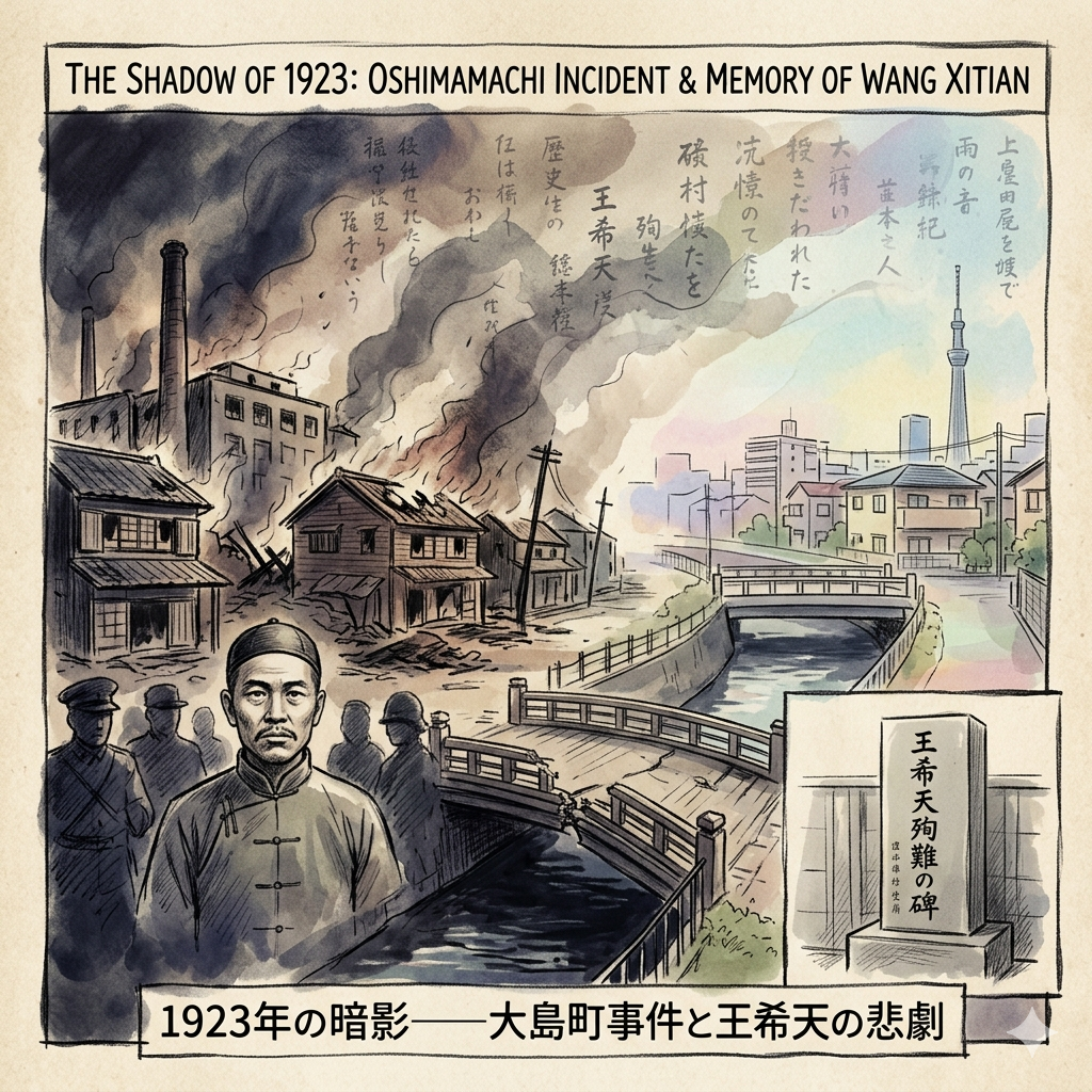
The Shadow of 1923: Memory and the Oshimamachi Incident
The fragility of Oshima’s social fabric was laid bare during the Great Kanto Earthquake of 1923. In the ensuing chaos, rumors and ethnic prejudice led to the "Oshimamachi Incident," where hundreds of Chinese laborers were targeted. Among the victims was Wang Xitian, a highly influential activist and protector of laborer rights. On September 12, while investigating the safety of his compatriots, he was murdered by military personnel near Sakasaibashi.
1923 Key Coordinates:
Location | Historical Significance |
Oshimamachi 8-chome | The primary site of violence against laborers following the earthquake. |
Sakasaibashi | The site of the martyrdom of activist Wang Xitian. |
Jyoshin-ji Temple | Location of the memorial monument dedicated to the victims. |
The "So What?" Layer: This tragedy reveals how the "frontier" can quickly become a site of exclusion during a crisis. Understanding Oshima today requires "history-mining"—recovering the voices of Chinese laborers and others suppressed by official narratives to understand the true cost of social collapse.
Spatial Narrative: Walking the Hidden History
The Oshima of today is defined by its massive UR Danchi (public housing complexes). However, these residential blocks are not random; they sit precisely upon the footprints of the chemical towers and industrial sites of the Meiji era. This spatial continuity means that even as you walk between modern apartments, you are moving through the "industrial ghosts" of Oshima’s past. (To see how this fits into the larger metropolitan puzzle, explore our Wider Historical Guide to Koto-ku).
The Nakagawa Funabansho Museum is an essential stop for the historically-minded traveler. Located just 50 meters from the original 1661 guard house site, it features a meticulous full-scale reconstruction of the 19th-century boat checkpoint. The experience is heightened by audio recreations of the tense dialogue between boatmen and shogunal officials, allowing you to hear the echoes of the "Eastern Gate" as it once functioned.
Conclusion: A Philosophical Reflection on the Layered City
Oshima serves as a living archive of human ambition and its unintended consequences. To understand this district is to accept that the city is not a static object but a "layered observation" of survival, control, and memory. The ground beneath Oshima remains physically unstable—a "zero-meter zone" prone to subsidence—much like the human memory that seeks to celebrate its victories while burying its darker hours.
As you stand on the banks of the Onagi River, consider the "unstable" nature of the land and the narratives built upon it: Can a city constructed on reclaimed land ever find a permanent identity, or is it destined to remain in a state of perpetual flux?
Subscribe to Historical Travel Stories for more deep-dive explorations into the hidden narratives of the world's great cities.
Logistics: The Traveler’s Toolkit
How to Experience Oshima
- Getting There: Take the Toei Shinjuku Line to Oshima Station. The district is best explored on foot to appreciate the subtle changes in elevation and canal-side markers.
- Recommended Tours: Walk the Onagi River canal paths starting from the Nakagawa Funabansho Museum toward the Katori Shrine to witness the transition from maritime security to spiritual history.
- Nearby Accommodation: The Koto-ku area offers several boutique hotels and business stays that provide a quiet, reflective alternative to the high-rise glitz of central Tokyo, ideal for those seeking proximity to the city’s water-bound history.
Q & A
What was the strategic importance of the Nakagawa Ship Guardhouse in Edo?
The Nakagawa Ship Guardhouse (中川船番所) served as a critical strategic node for military, political, and economic control during the Edo period. Often referred to as the "Eastern Gateway of Edo," its importance was derived from its location at the confluence of the Onagi River and the Kyu-Nakagawa River, a vital waterway junction.According to the sources, its strategic importance can be categorized into three main roles:
1. Military and Political SecurityThe guardhouse operated under the strict policy of "Inward Guns, Outward Women" (Iri-teppo, De-onna), which was essential for maintaining the Shogunate's authority,.
- Weapon Control: Officials strictly inspected ships for illegal firearms, gunpowder, and lead entering Edo to prevent local daimyo (lords) from staging rebellions,.
- Hostage Monitoring: It monitored women attempting to leave Edo; these women were often the families of daimyo held as hostages in the city to ensure the stability of the Sankin-kotai (alternate attendance) system,.
- Nighttime Ban: To ensure the absolute safety of the capital and prevent illegal escapes, ships were strictly prohibited from leaving Edo during the night,.
2. Logistical Control of the LifelineThe guardhouse oversaw the Onagi River, which was the primary canal for transporting essential resources into central Edo.
- Supply Chain Management: This waterway was the "lifeline" for moving grain from the Tohoku region and salt from the Boso region into the city.
- High Traffic Volume: The site was a bustling hub of activity, with a daily average of 500 to 600 ships passing through, and peak volumes exceeding 900 ships.
3. Economic Intelligence HubBeyond its role as a security checkpoint, the guardhouse evolved into a central data collection point for the Shogunate starting in the mid-Edo period.
- Trade Statistics: Officials recorded the types and quantities of goods entering Edo, providing the Shogunate with precise intelligence on national material flows and economic trends.
- Administrative Presence: Due to its importance, it was overseen by high-ranking Hatamoto (direct vassals of the Shogun) and maintained a 24-hour administrative presence to exert constant authority over the waterway.
The guardhouse also enforced strict identification protocols; all passengers were required to remove their hats and lift curtains so that officials could verify their identities, ensuring that no unauthorized individuals could slip into or out of the capital.
How is the historical memory of the 1923 earthquake preserved?
The historical memory of the 1923 Great Kanto Earthquake in the Ojima-machi area is preserved through a combination of physical monuments, geographical landmarks, and the persistent documentation of private and academic groups, particularly focusing on the "dark history" of the social violence that followed the disaster.The preservation of this memory can be categorized into the following forms:
1. Religious and Memorial MonumentsPhysical markers serve as the primary sites for honoring victims and ensuring the events are not forgotten:
- Jyoshin-ji Temple (Kameido): This temple houses a memorial monument established in 1970 that specifically records the names of those killed, including Wang Xitian, a prominent activist for Chinese labor rights.
- Arakawa Riverbed (Yahiro, Sumida): Private civilian groups have established a "Memorial of Mourning" (追悼之碑) along the riverbed to commemorate Korean and Chinese victims whose stories were often buried or obscured in official records.
2. Geographical Landmarks and "Fieldwork" CoordinatesBecause many official records were once suppressed or hidden, specific locations in the urban landscape have become "historical coordinates" for researchers and the public:
- Sakasaibashi (Inverse Bridge): Located near the current Higashi-Ojima Cultural Center, this site is preserved in historical memory as the location where Wang Xitian was killed by military personnel.
- Ojima-machi 8-chome: The area around the current Higashi-Ojima Cultural Center is identified as the site of the "Ojima-machi Incident," where hundreds of Chinese laborers were executed. These sites remain active locations for "fieldwork" and historical tours organized by local history enthusiasts.
3. Documentation and Research AdvocacyThe memory is also preserved through the efforts to fill "gaps" in official narratives:
- Civilian and Academic Research: Scholars and private organizations have worked to uncover truths about the ethnic violence, using resources like the 1923 investigation tables from the Chinese Embassy and declassified Ministry of Foreign Affairs files.
- Legal Recognition: Groups such as the Japan Federation of Bar Associations (JFBA) have issued recommendations for truth-seeking, ensuring that the legal and human rights violations of the era remain a part of the public discourse.
4. Symbolic Representation of "Vulnerability"The sources suggest that the memory of the 1923 earthquake is preserved as a lesson in multi-dimensional urban vulnerability. It is remembered not just as a natural disaster involving collapsed buildings, but as a collapse of the "social contract," where ethnic chauvinism and military overreach led to tragedy. This serves as a warning in modern urban planning and historical education to remember the fragility of human rights during emergencies.
Reference and Further reading
- お知らせ詳細 | 奥村商事株式会社 | 肥料販売を礎に農業の多角的経営 ..., accessed April 10, 2026,
- 旧町名 江東区大島町 - 歩・探・見・感, accessed April 10, 2026,
- 江東区大島について, accessed April 10, 2026,
- 江戸散策 | クリナップ, accessed April 10, 2026,
- Nakagawa Funabansho Museum Guided Tour 2025 中川船番所資料館 常設展示室解説動画, accessed April 10, 2026,
- 観光スポット - 中川船番所跡 (注:史跡) - 江東おでかけ情報局, accessed April 10, 2026,
- 中 川 番 所 - 江戸川区, accessed April 10, 2026,
- 中川船番所資料館【江東区】 旧中川と小名木川の歴史資料を見学 - 江戸川フォトライブラリー, accessed April 10, 2026,
- 中川船番所資料館 - 東京とりっぷ, accessed April 10, 2026,
- 中川船番所跡 - 江東区, accessed April 10, 2026,
- 中川船番所資料館 江戸時代の江東区を探索をしよう! - アソビュー!, accessed April 10, 2026,
- 江東区中川船番所資料館 - 見どころ、アクセス、口コミ & 周辺情報 | GOOD LUCK TRIP, accessed April 10, 2026,
- 中川船番所資料館 - 江東区, accessed April 10, 2026,
- 亀戸香取神社 / 東京都江東区 | 御朱印・神社メモ, accessed April 10, 2026,
- 香取神社 - 江東区 - 東京都神社庁, accessed April 10, 2026,
- 香取神社について|スポーツ振興の神 亀戸 香取神社, accessed April 10, 2026,
- 亀戸七福神巡りのお誘い, accessed April 10, 2026,
- 御由緒 | 香取神宮, accessed April 10, 2026,
- 写真 土壌汚染(1)-2 - 東京都環境局, accessed April 10, 2026,
- 東京の海抜0メートル地帯へ (江東区・江戸川区) - YouTube, accessed April 10, 2026,
- 日産化学/会社沿革, accessed April 10, 2026,
- 6:工業地から都心近接の住宅エリアへ ~ 深川・城東 - 三井住友トラスト不動産, accessed April 10, 2026,
- 株式会社 LIXIL 本社移転のお知らせ 【新本社 ご案内図】 - LIXIL | ニュースリリース, accessed April 10, 2026,
- LIXILが大島の本社屋を土地ともに売却 - Tecture mag, accessed April 10, 2026,
- 関東大震災96年 朝鮮人犠牲者を追悼 - 季刊・現代の理論, accessed April 10, 2026,
- 亀戸かめいどに関東大震災虐殺事件の現場を訪ねる, accessed April 10, 2026,
- 関東大震災下の中国人虐殺事件が - 明らかにされるまで, accessed April 10, 2026,
- 関東大震災での虐殺事件はなぜ起こったのか? - 法政大学鈴木靖研究室, accessed April 10, 2026,
- 関東大震災朝鮮人・中国人虐殺100年 - 季刊・現代の理論, accessed April 10, 2026,
- 「追悼の碑」建立 関東大震災で虐殺された同胞しのぶ - 在日本大韓民国民団, accessed April 10, 2026