(ENG) Shikamoto-mura Historical Walk – A Tale of Sacred Deers, Shogun’s Greens, and a Vanished Village in Tokyo
Journey through the "vanished village" of Shikamoto-mura. From the legendary path of divine deers to the Shogun’s favorite greens, discover the resilient spirit and historical layers of this Edogawa district, now largely submerged beneath the vast Arakawa River.

This is a historical travel story and walking guide to Shikamoto-mura, a vanished administrative district in Tokyo’s Edogawa. By exploring ancient shrines and local heritage sites, it reveals how this peripheral land transformed from a sacred medieval corridor to a modern sacrifice for flood control. Readers will discover the origins of Komatsuna, the legend of the divine deer, and the poignant history hidden beneath the Arakawa Discharge Channel.

The Village Under the Water and Asphalt
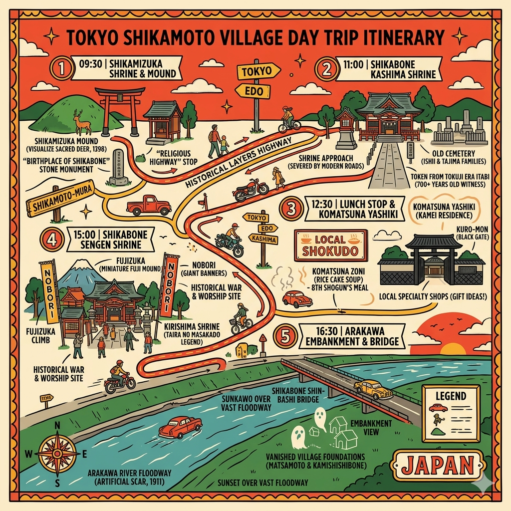
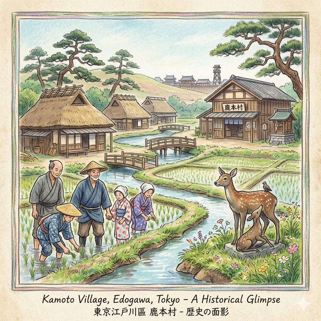
To walk the modern residential streets of Edogawa is to tread upon a geographic palimpsest—a landscape where layers of sacred myth, feudal economics, and radical engineering have been stacked and, in some places, violently scraped away. At the heart of this narrative lies Shikamoto-mura. Established in 1889 and dissolved in 1932, this administrative unit was a brief 43-year coda to a thousand-year history of the eastern lowlands.
Strategically positioned as a transition point between the capital and the eastern provinces, this borderland was never merely a peripheral marsh. It was a site where power was negotiated through water management and faith. If you stand today at the edge of the Arakawa, you are looking at the site of a "deleted village." Beneath the asphalt of Shishibone and the deep currents of the discharge channel lie the ghosts of five medieval natural villages—Kami-isshiki, Hon-isshiki, Okimiya, Matsumoto, and Shishibone—each contributing a layer to this [Guide to Tokyo’s Historical Lowlands]. The story begins not with man, but with a messenger of the gods.
Listen to the historical stories told in detail (For subscribers only)
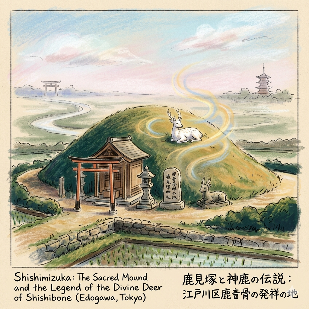
The Messenger of the Gods: Landscape Layering at the Shishimizuka
The oldest layer of this landscape is etched into the earth at the Shishimizuka (Deer-Seer Mound). The name "Shishibone" (Deer Bone) appears in records as early as the 1398 Kasai-mikuriya documents, identifying the area as a medieval economic and religious estate. However, the mound represents a more profound "religious traffic" system that integrated this peripheral land into the national power structure of the Kashima-Kasuga axis.
The legend tells of the deity Takemikazuchi-no-mikoto traveling from the Kashima Shrine toward the Kasuga Shrine in Nara. A divine deer, acting as a messenger, collapsed and died upon reaching this marshy borderland.
"The local residents, recognizing the divine nature of the messenger, did not treat the creature as a common animal. Instead, they perceived a sacred connection to the gods, constructing a mound to entomb the deer and offer perpetual prayers. Thus, the land became Shishibone—the bones of the deer."
This was a sophisticated political tool. By linking their local soil to the deer of the Fujiwara clan’s tutelary shrines, the inhabitants claimed significance in the national religious landscape. Furthermore, the Shishimizuka is likely a repurposed ancient kofun (burial mound). By building upon a prehistoric power site, medieval residents validated their new religious connections through "landscape layering," a classic technique of deep mapping where one era’s sacred site is cannibalized to sanctify the next.
Observation Point: Visit the Shishimizuka Shrine in Shishibone 3-chome. Look for the stone markers designating this as the "Birthplace of Shishibone." Notice how the mound’s placement served as a spiritual waypoint on the ancient route between the eastern shrines and the central capital.
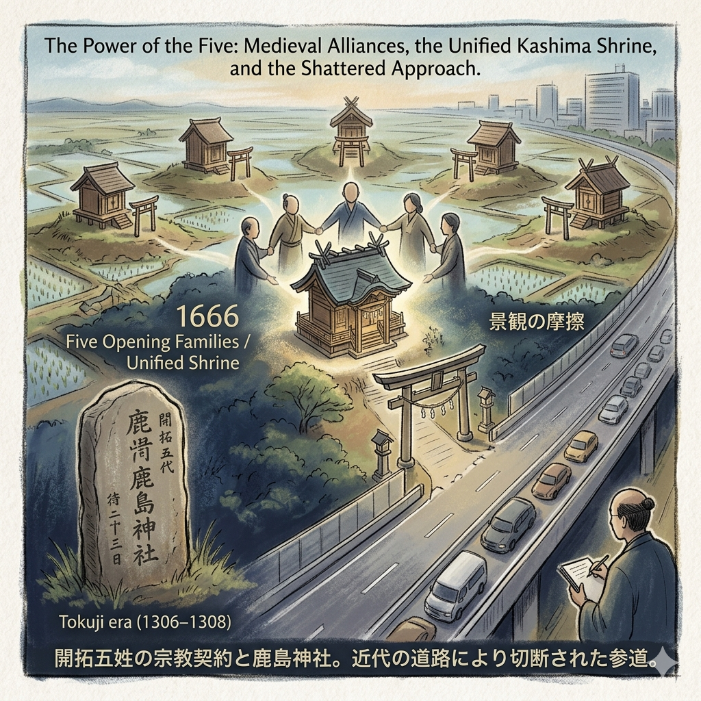
The Power of the Five: Medieval Alliances and the Kashima Shrine
As the sacred landscape stabilized, the human landscape followed. The social bedrock of Shikamoto-mura was formed by the Kaitaku Gosei—the Five Opening Families. In the harsh, flood-prone lowlands, survival required a "religious contract" to manage the unpredictable environment.
In 1666, these families consolidated their individual household deities (ujigami) into a single unified "Village Shrine," now the Shishibone Kashima Shrine. This transition to a collective civic identity was essential for managing complex water rights. Proof of the village's deep longevity exists here in the form of a stone tablet (itabi) dating to the Tokuji era (1306–1308), predating the written 1398 record.
Family Name | Historical Background | Socio-Political Role (Edo Period) |
Ishii Nagakatsu | Descendant of Shimosa samurai | Primary pioneer and long-term village headman (Nanushi). |
Tajima Clan | Experts in hydraulic engineering | Responsible for water system maintenance and irrigation (Kumigashira). |
Nakadai Clan | Migrants with regional ties | Managed diplomatic negotiations with neighboring villages. |
Makino Clan | Military heritage | Tasked with border protection and village security. |
Second Ishii Clan | Expansion branch of the main line | Organized labor and grassroots community mobilization. |
This alliance turned the village into a self-governing entity. Today, the scholar-flâneur will notice the "shattered" nature of this sacred space; the shrine’s original approach was severed by modern road expansion, a physical reminder of how the motor age prioritizes transit over tradition.
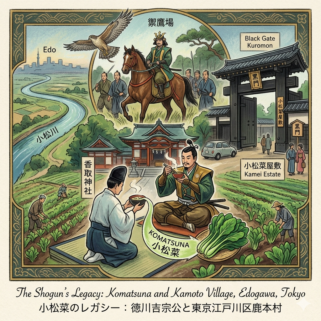
The Shogun’s Palate: How "Komatsuna" Redefined the Lowland Economy
By the 18th century, Shikamoto-mura’s relationship with power shifted toward the culinary. In 1719, Shogun Tokugawa Yoshimune visited the area during a falconry expedition. This was "political branding"—the Shogun used these visits to inspect agricultural productivity and reinforce his presence in [The Shogun’s Landscapes].
While resting at the Katori Shrine, Yoshimune was hosted by the Kamei family. Lacking lavish ingredients, the priest harvested a vibrant green growing nearby and served it in a Zoni (mochi soup).
"The Shogun was so impressed by the sweet, crisp flavor of the unnamed vegetable that he inquired about its name. Upon learning it had none, he christened it 'Komatsuna,' after the nearby Komatsugawa River, instantly transforming a local staple into a brand of the capital."
This transformed the local economy from subsistence to high-value commercial agriculture. The Komatsuna Yashiki (Kamei Estate), with its imposing "Black Gate" (Kuromon), remains a symbol of the high social status these local leaders attained.
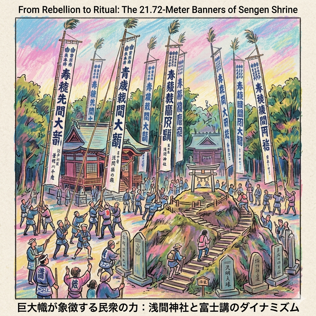
From Rebellion to Ritual: The 21.72-Meter Banners of Sengen Shrine
While the Shogun’s greens brought prosperity, the Sengen Shrine (est. 938 AD) preserved a memory of rebellion. Originally a spiritual outpost during the Taira no Masakado uprising, it later became a site of "community labor" through the Fuji-ko cult, led by the charismatic Jikyo Miroku.
The most striking manifestation of village solidarity is the Nobori Matsuri (Raising of the Banners). Every two years, the village coordinates to raise massive banners, precisely 21.72 meters (12 ken) high. This is a "spatial drill"—an engineering feat requiring the synchronized labor of the entire community.
Field Note: Within the shrine grounds, climb the Fuji-mound (Fujizuka). These man-made hills allowed local farmers—who could rarely leave their fields—to perform a symbolic pilgrimage to Fuji’s summit. Observe the itabi and the "Sengen-sama no Mori" (Forest of Sengen) that surrounds the site.
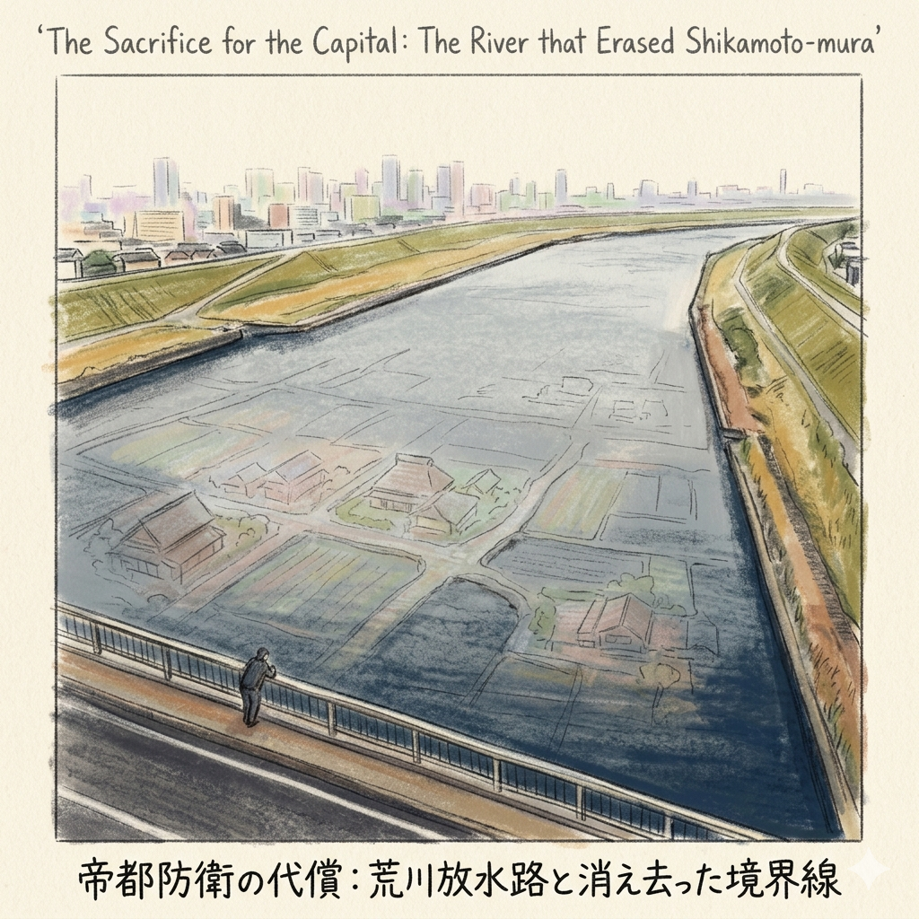
The Sacrifice for the Capital: The River that Erased Shikamoto-mura
The end of Shikamoto-mura was brought about by "State Spatial Violence." Following the Great Flood of 1910, which devastated Tokyo’s center, the Meiji government decided to sacrifice the periphery to save the imperial core.
Between 1911 and 1930, the Arakawa Discharge Channel was carved through the earth. This man-made river, 500 meters wide, acted as a literal blade, severing ancestral connections. The administrative center and the farms of Matsumoto and Kami-isshiki were reclaimed by the state and turned into a riverbed. By 1932, the village was dissolved.
Spatial Reflection: Stand on the Shishibone New Bridge. Looking down at the vast expanse of water, realize you are hovering over the submerged foundations of Matsumoto and Kami-isshiki. The river is not a natural feature; it is a monument to the village sacrificed for the security of Imperial Tokyo.
The Narrative Geographer’s Choice: The Hidden Gem
If you wish to find the last true remnant of the pre-flood atmosphere, seek out the Sengen-sama no Mori (The Forest of Sengen). Designated as a "protected urban forest" of Edogawa Ward, this grove preserves the original micro-climate and spatial logic of a lowland village grove. It is one of the few places where the original "logic" of the land has escaped both the shovel of the Arakawa project and post-war urbanization.
Conclusion: The Layered Observation
Understanding a city requires "layered observation"—the ability to recognize that even when a village is removed from a map, its logic remains imprinted on the physical world. Shikamoto-mura is not truly gone; it has merely become a ghost in the machine of the modern metropolis. Its existence persists in the curve of a road that once traced a medieval irrigation canal, in the placement of a stone deer at a repurposed burial mound, and in the "Black Gate" of a family that once hosted the Shogun.
The history of this land is a cycle of continuity and erasure. The sacred messengers gave it a name, the five families gave it a social structure, and the Shogun gave it an economy. While the 1910 floods and the resulting Arakawa project physically severed the land, the spirit of the village survives in the rituals of the Sengen Shrine and the quiet persistence of the Sengen-sama forest. To walk here is to acknowledge that the "Imperial" city we see today was built upon the literal and figurative foundations of places like Shikamoto-mura. We must learn to read these urban ghosts, for they remind us that every street we walk is a story waiting to be reclaimed.
For more "Deep Mapping" stories or to share your own discoveries of Tokyo’s lost places, consider exploring our further field guides.
Logistics & Practical Details
How to Get There:
- Toei Shinjuku Line: Alight at Shinozaki Station. It is a 15-minute walk to the Sengen Shrine.
- JR Sobu Line: Alight at Koiwa Station. Local buses provide access to the Shishibone area.
Walking Route Suggestion: Begin at the Shishibone Kashima Shrine to pay respects to the "Five Families," walk through the residential heart to the Shishimizuka Shrine, and conclude your journey on the Arakawa Embankment near the Shishibone New Bridge to reflect on the landscape of loss.
Recommended Tours: For those seeking a guided experience, look for local "Edogawa Heritage Walks" or seasonal tours of the Kamei Estate and local traditional gardens, which highlight the area's deep agricultural roots and the legacy of Komatsuna.
Q & A
Quel est le lien entre le shogun et l'origine du Komatsuna ?
Le lien entre le shogun et l'origine du Komatsuna (小松菜) repose sur un acte de baptême officiel réalisé par le 8ème shogun, Tokugawa Yoshimune, lors d'une visite impromptue dans la région de l'actuel Edogawa.Voici les détails historiques de cette connexion :
- Le contexte de la rencontre : En 1719 (Kyoho 4), durant les réformes de Kyoho, Tokugawa Yoshimune s'est rendu dans les zones de Shikamoto et Komatsugawa pour pratiquer la fauconnerie (takagari), une activité qui servait à la fois d'entraînement militaire et d'inspection des terres agricoles.
- Le repas au sanctuaire : Lors de sa pause déjeuner au sanctuaire Katori, le shogun a été reçu par le prêtre Kamei Izuminokami. Ce dernier a préparé une soupe de mochi (zoni) en utilisant un légume vert local qui n'avait alors aucun nom officiel.
- Le baptême royal : Tokugawa Yoshimune a été séduit par ce légume, appréciant sa résistance au froid ainsi que sa saveur équilibrée entre douceur et légère amertume. En apprenant que la plante était anonyme, il a décidé de la nommer « Komatsuna », d'après le nom de la localité voisine, Komatsugawa.
- L'impact économique et politique : Cette reconnaissance par le chef de l'État a agi comme une véritable « certification officielle ». Suite à cela, la région s'est transformée en un centre de production commerciale intensive pour approvisionner le marché d'Edo (Tokyo), marquant le passage d'une agriculture d'autosubsistance à une économie de rente basée sur les légumes de marque.
Bien que la tradition attribue la découverte au shogun, les sources précisent que le Komatsuna n'était pas une plante purement sauvage : il s'agissait du résultat d'une sélection minutieuse effectuée par les agriculteurs locaux pour s'adapter aux conditions climatiques humides et froides des basses terres. Aujourd'hui, la résidence de la famille Kamei, connue sous le nom de « Komatsuna-yashiki », ainsi qu'une stèle commémorative au sanctuaire Katori, témoignent toujours de ce lien historique.
Comment la construction du canal Arakawa a-t-elle transformé le paysage local ?
La construction du canal de décharge d'Arakawa (Arakawa放水路), lancée en 1911 à la suite des inondations dévastatrices de 1910, a provoqué une métamorphose radicale et irréversible du paysage de la région de Shikamoto,. Cette transformation s'est opérée à plusieurs niveaux :
1. Destruction physique et submersion des terres
Le projet consistait à creuser une rivière artificielle massive de 500 mètres de large. Cette intervention a littéralement effacé des parties entières du paysage local :
- Engloutissement de villages : De vastes zones de terres agricoles, des zones résidentielles, des sanctuaires et même le bureau municipal (yakuba) des secteurs de Kami-isshiki et Matsumoto ont été expropriés et se retrouvent aujourd'hui sous le lit du fleuve.
- Perte de territoire : À titre d'exemple, environ un tiers du village de Nishikomatsugawa a été transformé en lit de rivière.
2. Passage d'un paysage naturel à un paysage d'ingénierie
Avant le projet, la zone était une basse terre naturelle régie par les cycles de l'eau. Le chantier a imposé la volonté de la bureaucratie technique de l'époque sur la nature :
- Contrôle hydrologique total : Le cours de la rivière Nakagawa a été coupé et les niveaux d'eau sont désormais précisément contrôlés, marquant la transition d'une zone humide agricole vers un paysage artificiel,.
- Paysage surréaliste : Aujourd'hui, depuis les digues d'Arakawa, on observe un lit de rivière d'une largeur presque irréelle, qui cache sous ses eaux les fondations des anciens villages disparus.
3. Rupture sociale et administrative
Le canal n'a pas seulement modifié la géographie, il a agi comme une lame tranchante sur la structure sociale :
- Scission physique : Le canal a divisé les communautés autrefois unies en deux parties distinctes, rendant les interactions quotidiennes impossibles à cause de cette immense barrière artificielle.
- Fin de l'entité administrative : Cette barrière est devenue une frontière naturelle utilisée lors de l'expansion du Grand Tokyo en 1932, entraînant le démantèlement définitif du village de Shikamoto et l'intégration de ses morceaux dans différents arrondissements.
4. Sacrifice de la périphérie pour le centre
Historiquement, ce changement de paysage témoigne d'une « violence spatiale » exercée par l'État moderne : pour garantir la sécurité du centre de Tokyo (Edo-shitamachi), le paysage rural et les intérêts des habitants de la périphérie, comme ceux de Shikamoto, ont été sacrifiés au nom de l'intérêt national.
Bien que le paysage administratif de Shikamoto ait disparu, certains vestiges ont été déplacés, comme l'ancien site de la mairie de Matsue, qui a repris une partie des fonctions administratives du village après sa destruction.
Reference and Further reading
- 江戸川区「鹿本」の地名の由来 - 金井たかし(カナイタカシ) - 選挙ドットコム, accessed April 19, 2026,
- https://www.city.edogawa.tokyo.jp/e037/kurashi/chiikicommunity/johokyoku/shishibone/shokai.htm
- 「鹿骨・鹿見塚」と「鹿島神宮・春日大社」との深い縁~鹿は神の使い【江戸川歴史散策】, accessed April 19, 2026,
- 【 鹿骨】 - ADEAC, accessed April 19, 2026,
- 鹿骨鹿島神社|江戸川区鹿骨の神社 - 猫の足あと, accessed April 19, 2026,
- 石井氏とは? わかりやすく解説 - Weblio辞書, accessed April 19, 2026,
- 第九五五回 鹿島神社(江戸川区鹿骨) | 江戸御府内千社参詣, accessed April 19, 2026,
- 鹿島神社 (江戸川区) - accessed April 19, 2026,
- 花のまち鹿骨の春、夏の花火、静かなる歴史の旅への誘い, accessed April 19, 2026,
- 江戸時代、時の将軍に名前をつけてもらった野菜は? - やさいde日本史クイズ|知る・楽しむ/ サラダカフェ Salad Cafe, accessed April 19, 2026,
- 35 由来を伝える小松菜屋敷 江戸川区ホームページ - 東京, accessed April 19, 2026,
- 将軍吉宗に命名された江戸のブランド野菜「小松菜」豊富な栄養素で免疫力もアップ, accessed April 19, 2026,
- 徳川吉宗が名付け親 小松菜を使った献立 - 株式会社東京天竜, accessed April 19, 2026,
- 江戸川区発祥の「小松菜」のこと, accessed April 19, 2026,
- 東京都江戸川区の江戸東京野菜「小松菜」1-小松菜発祥の地・小松菜の名前の由来・新小岩香取神社・小松菜屋敷・江戸川区の小松菜商品 - コウジ菌のブログ, accessed April 19, 2026,
- 篠崎浅間神社 幟祭り, accessed April 19, 2026,
- 5年ぶりの開催!篠崎浅間神社幟祭り!天高くそびえる日本最大級の幟で運気アップ!, accessed April 19, 2026,
- 1 研究報告ノート 「信仰の対象としての富士山―富士講の月次講を中心に―」, accessed April 19, 2026,
- 富士講 - accessed April 19, 2026,
- 荒川放水路変遷誌[PDF - 関東地方整備局, accessed April 19, 2026,
- 第10回里川文化塾 船でゆく荒川〜人工水路と暮らしの接点, accessed April 19, 2026,
- 明治43年の洪水 ~明治政府を動かした大洪水~, accessed April 19, 2026,
- 明治・大正・昭和期に行われた荒川放水路開削工事と 市民の生活, accessed April 19, 2026,
- 知っていますか?荒川放水路のこと「荒川放水路通水100周年」 - 足立区, accessed April 19, 2026,
- 松江町役場跡 - 東京都江戸川区の歴史, accessed April 19, 2026