(ENG) Sunamachi Historical Walk – Resilience in Tokyo’s Sinking Zero-Meter Zone
Sunamachi is a "palimpsest" of human will and natural forces. Walk through Tokyo’s industrial heartland to see how 4.57 meters of land subsidence and WWII firestorms shaped the unique resilience of Sunamachi Ginza—a place where history is felt underfoot in every sun-drenched alley.

This is a historical travel story and walking guide to Sunamachi, a resilient "Zero-Meter Zone" in eastern Tokyo. Through layers of urban archaeology, it explores the Onagi-gawa canal, the legendary Sunamachi Ginza market, and the scars of WWII to show how a community built on sinking soil survived industrial exhaustion and firestorms to become Tokyo’s beloved "Sozai Holy Land."

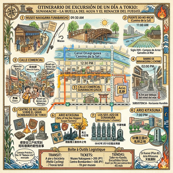
The expansion of Tokyo has always been a calculated gamble against the elements—a relentless negotiation between man, marshland, and the sea. Located in the eastern reaches of Koto City, the district of Sunamachi serves as a profound testament to this struggle. Once a collection of desolate sandbars at the confluence of the Tone and Arakawa rivers known as "Borokujima," this "Zero-Meter Zone" evolved from a feudal breadbasket into a titan of the Meiji industrial era, before settling into its current identity as a bastion of post-war resilience. To walk the streets of Sunamachi is to engage in a physical encounter with time; here, the very grid of the city is etched with the scars of land reclamation and survival. It is a place where history is not merely observed in museums but felt underfoot in the varying elevations of its sun-drenched alleys.
Listen to the historical stories told in detail (For subscribers only)
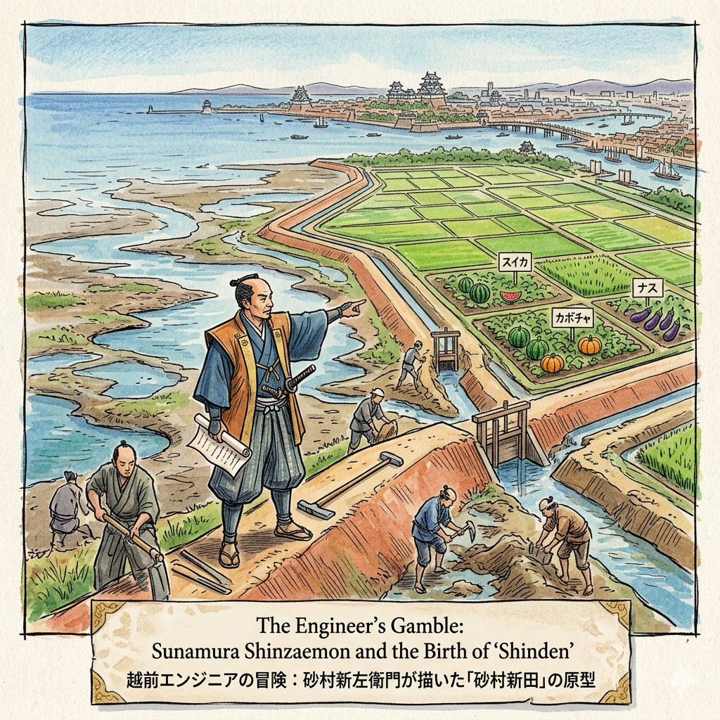
The Engineer’s Gamble: Sunamura Shinzaemon and the Birth of "Shinden"
The story of Sunamachi begins in the 17th century, during the "Great Development Era" of the Tokugawa Shogunate. As the population of Edo exploded, the shogunate faced a geopolitical necessity: securing a stable food supply. This requirement transformed the lagoons and sandbars into a site of radical engineering. Into this fray stepped Sunamura Shinzaemon, a technical expert from Echizen Province who transitioned from a mere technician to a regional power broker. Shinzaemon was no local tinkerer; his authority was established through a vast reclamation network that included the "Yoshida Shinden" in Yokohama and "Uchigawa Shinden" in Yokosuka, projects that effectively redrew the coastline of the Edo Bay.
Shinzaemon employed Kantaku (drainage) technology, a sophisticated method of building "Choryu-堤" (tide-shielding levees) to enclose tidal flats, draining the water, and desalinating the soil to create "Sunamura Shinden" (Sunamura's New Fields). This private-public partnership model shifted the boundary of the city from liquid marsh to productive "property space," turning the area into a vital breadbasket that supplied Edo with watermelons, pumpkins, and eggplants. Today, the "Suna" prefix in neighborhoods like Minami-suna and Kita-suna serves as a rare linguistic monument to Shinzaemon, a testament to a civil engineer who willed the land into existence.
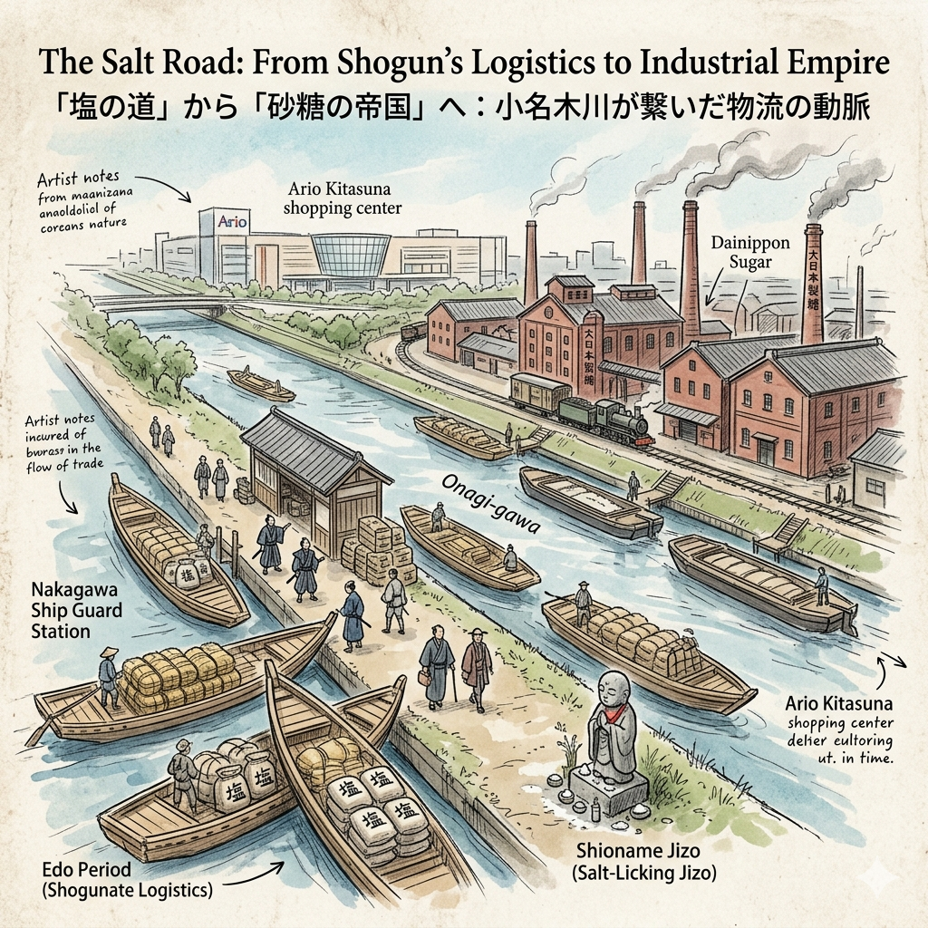
The Salt Road: From Shogun’s Logistics to Industrial Empire
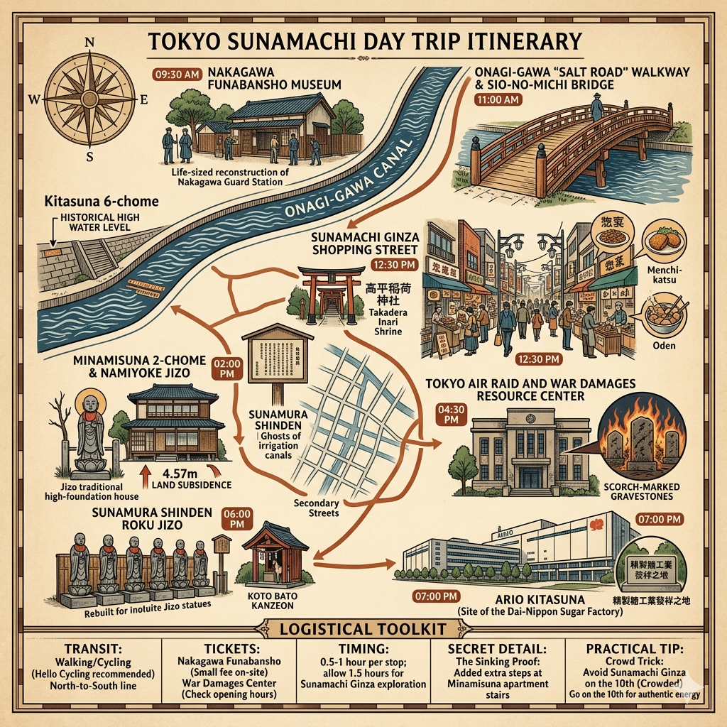
If Shinzaemon provided the land, the Onagi-gawa canal provided the lifeblood. In 1590, Tokugawa Ieyasu recognized a strategic vulnerability: Edo’s salt supply, harvested in Gyotoku, was transported via the open sea, where winter winds and shallow reefs frequently led to shipwrecks. To secure this vital resource, the Onagi-gawa was cut through the delta, creating a protected "Salt Road." By 1661, the shogunate established the Nakagawa Ship Guard Station at the canal’s eastern end, a military checkpoint monitoring "incoming guns and outgoing women" to ensure the security of the capital.
As Japan entered the Meiji period, the canal’s role pivoted from feudal control to industrial heartland. The proximity to water made Sunamachi an ideal hub for heavy industry, most notably the "Dainippon Sugar" factory in Kita-suna. Today, the sprawling Ario Kitasuna shopping center sits atop the site where sugar was once refined, a modern landmark anchored in industrial history. This transition from military artery to capitalist engine is best captured by local folk memory at Hota-ji temple. Here stands the Shioname Jizo (Salt-Licking Jizo); legend says salt merchants would offer a pinch of their precious cargo to the deity to ensure safe passage along the canal, a practice of gratitude that survives today as locals offer salt to pray for physical healing.
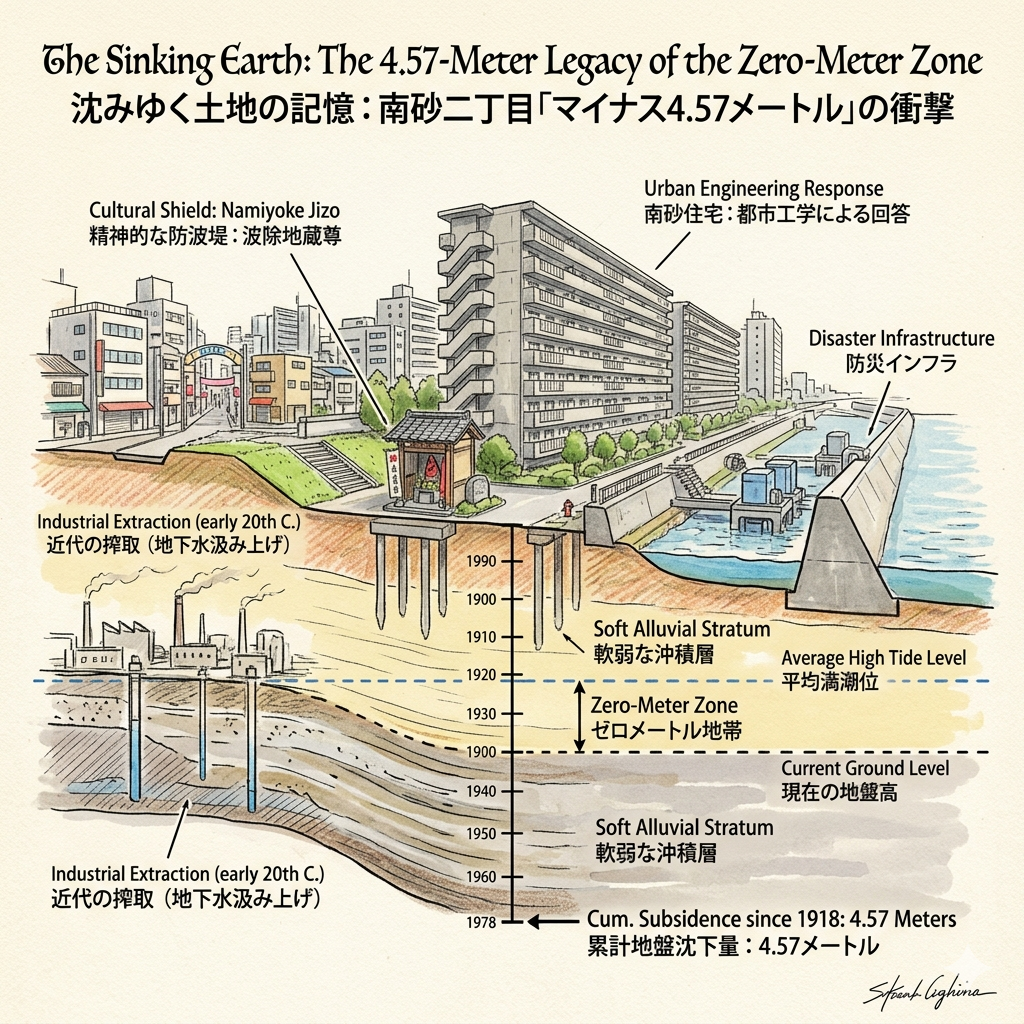
The Sinking Earth: The 4.57-Meter Legacy of the Zero-Meter Zone
In the 20th century, Sunamachi’s relentless industrial progress extracted a catastrophic price from the land itself. The extraction of groundwater for sugar and chemical factories led to dramatic land subsidence—not a natural disaster, but a direct physical manifestation of exhausted "natural capital." The metrics of this decline are staggering: since 1918, the ground in Minami-suna 2-chome has dropped by 4.57 meters. Large portions of the district now sit below the average high-tide level, officially designated as a "Zero-meter zone."
This literal drop in elevation reflected the "vulnerability politics" of the era, where the laboring classes resided in a landscape of constant precarity. This vulnerability was lethally proven during the Great Typhoon of 1917, which caused catastrophic flooding and loss of life as the sea reclaimed the sunken fields. Cultural responses to this environmental fragility remain visible at the Namiyoke Jizo (Wave-Shielding Jizo), a deity honored by residents who lived with the constant fear of the tide. The district's survival today depends on a "disaster infrastructure" of massive floodwalls and pumping stations, a permanent engineering defense against the very soil's exhaustion.
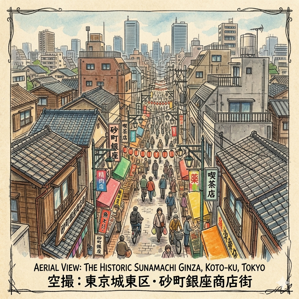
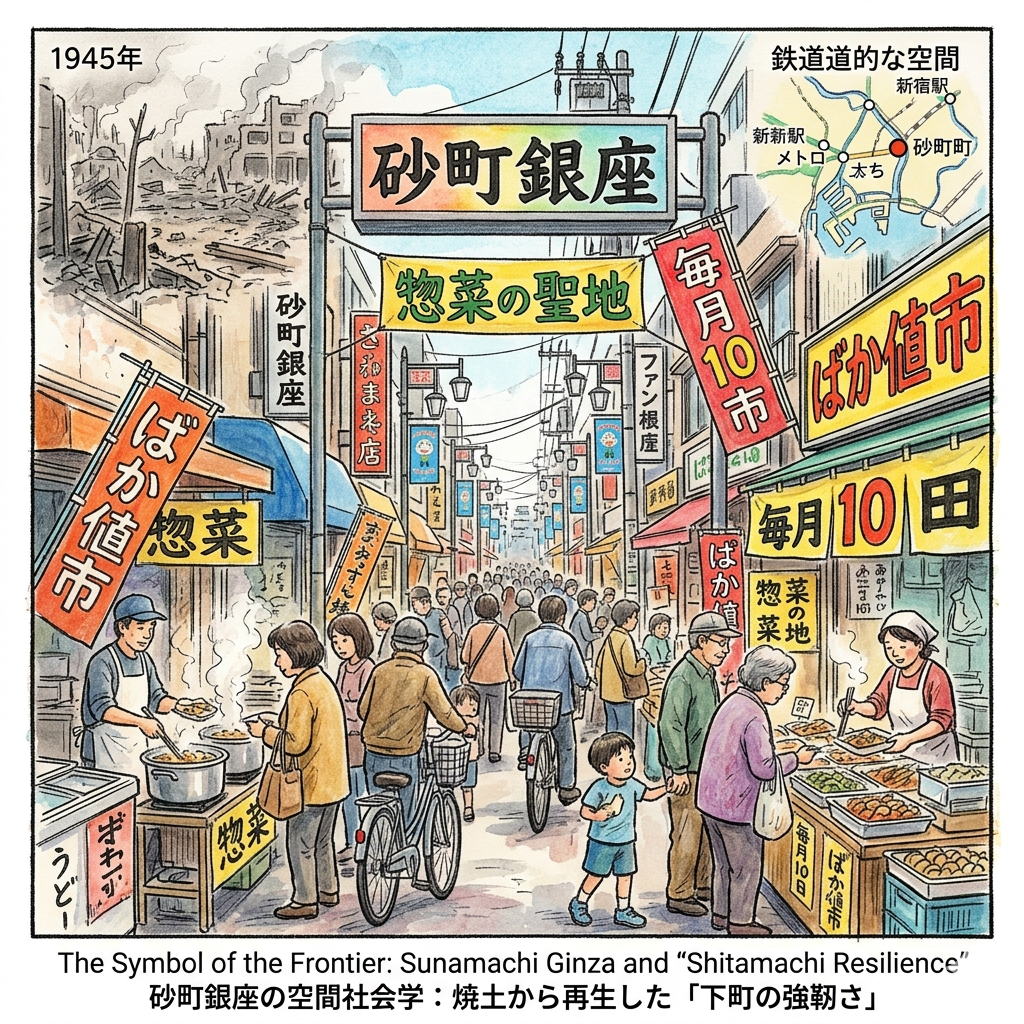
The Symbol of the Frontier: Sunamachi Ginza and "Shitamachi Resilience"
The most vibrant expression of local identity is found at Sunamachi Ginza. In 1932, local merchants adopted the name "Ginza"—Tokyo’s most elite center—as a symbol of aspiration for their peripheral laboring community. The market’s history is a narrative of destruction and rebirth; in 1945, many shops were forcibly demolished to create firebreaks before the Great Tokyo Air Raid reduced the remainder to ashes. Yet, the post-war resurrection was swift, transforming the street into a "惣菜 (Sozai) Holy Land" to feed dual-income factory families.
Every 10th of the month, the market hosts the "Baka-ne-ichi" (Stupidly Cheap Sale), a tradition born from post-war inflation-fighting that continues to draw thousands. Ironically, Sunamachi’s "railway blank space"—its geographic isolation from metro stations—protected the 670-meter street from the corporate homogenization seen elsewhere in Tokyo. It remains a rare, human-scale environment where high-density social interaction is the primary currency.
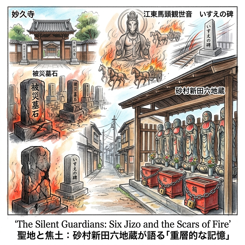
The Silent Guardians: Six Jizo and the Scars of Fire
Scattered throughout Sunamachi are silent anchors of memory that reflect a shift in folk religion from boundary protection to war memorialization. The Sunamura Shinden Roku Jizo, once Edo-period markers of the village limits, were destroyed in the 1945 firebombings. Rebuilt in 1952, they now serve as guardians for the repose of war victims. Notably, the money boxes at these shrines are often secured with heavy chains and locks, a gritty detail reflecting the lived reality of this working-class district.
Other monuments tell more specific tragedies: the "Isue" monument at the site of the old Onagi-gawa station honors twelve railway workers who died at their posts during the raids, while the Koto Batou Kannon (Horse-headed Kannon) commemorates the thousands of horses—the essential labor of the industrial district—lost in the firestorms. These grassroots monuments, funded by local residents rather than the state, provide an intimate narrative of loss. At Myokyu-ji, the "burned tombstones" remain as physical residue:
"One can still see fragments of graves with scorched surfaces and chipped edges—the physical residues of the 'fires of hell' that swept through in 1945."
Historical Synthesis and Philosophical Reflection
To walk through Sunamachi is to observe the "幾何直線" (geometric straight lines) of its secondary streets—the ghosts of the irrigation and drainage canals that once defined the Shinden. Sunamachi is more than a district; it is a survival narrative that has endured high tides, sinking soil, and total fire. It exemplifies the "frontier spirit" of Tokyo, where the city does not merely expand, but constantly reinvents itself on the edge of the possible.
Understanding a city requires this layered observation of its scars. Resilience is not the absence of trauma, but the ability to build within it. As you stand on soil that has dropped nearly five meters in a century, you are forced to ask: How do we value the "invisible" foundations of the cities we inhabit? In Sunamachi, the ground is both sinking and indestructible, a paradox of urban life that persists despite every attempt by nature and war to reclaim it.
The Hidden Gem: A Repository of Local Memory
For a deeper encounter with the district’s gravity, visit the Tokyo Air Raid and War Damage Resource Center in Kitasuna. This privately-funded museum houses vivid testimonies and models of incendiary bombs, ensuring the local memory of the 1945 raids is preserved through the eyes of those who survived it, rather than through the lens of official city narratives.
To receive more deep-history explorations of Tokyo’s hidden layers, consider subscribing to our monthly series.
Access & Exploration
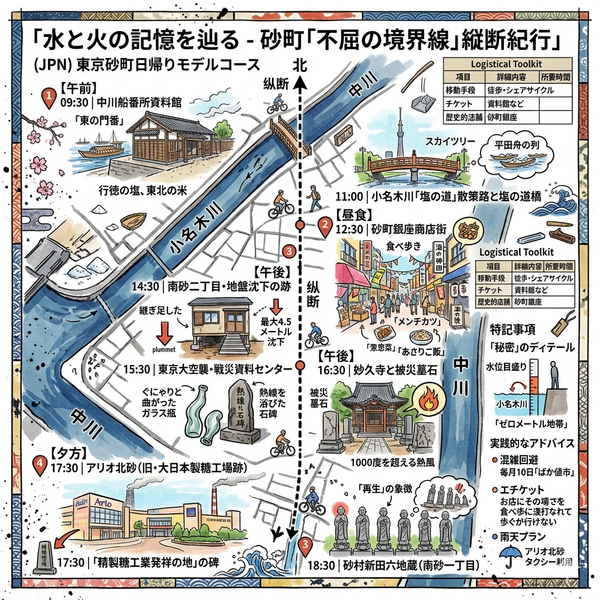
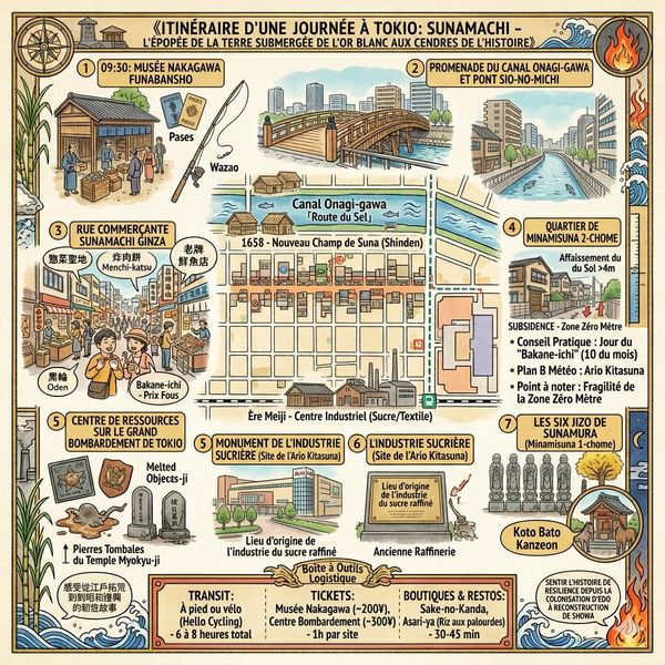
How to Get There Sunamachi is a 15-minute walk from Ojima Station (Toei Shinjuku Line) or Minami-sunamachi Station (Tokyo Metro Tozai Line).
Walking Route Begin at the Onagi-gawa canal. Observe the height markers on the floodwalls, which visually document the 4.57-meter subsidence. Walk south toward Sunamachi Ginza to experience the "Sozai Holy Land." Conclude at Myokyu-ji to see the "burned tombstones" and the Sunamura Shinden Roku Jizo.
Recommended Tours "Historical Shitamachi Walking Tours" offer guided insights into the engineering of the "Zero-meter zone" and the agricultural roots of the Koto City delta.
Q & A
Why did Sunamachi sink over four meters during the 1900s?
Sunamachi's dramatic sinking of over four meters during the 1900s was primarily an environmental consequence of Japan's rapid industrialization. The phenomenon, known as land subsidence, was most severe in the Minamisuna 2-chome area, where the ground level dropped by a cumulative 4.57 meters starting from 1918.According to the sources, the subsidence was caused by the following factors:
1. Massive Extraction of Groundwater and Natural Gas
The core cause was the excessive pumping of groundwater by modern factories (such as paper, sugar, and chemical plants) that proliferated in the area during the early 20th century. In the 1950s and 1960s, during the peak of post-war economic recovery, the subsidence reached its zenith due to both industrial water needs and the extraction of water-soluble natural gas.
2. Unstable Geological Foundation
The physical makeup of the land made it particularly vulnerable. Sunamachi is built on an unstable alluvial layer consisting of clay and silt deposited by the Tone River. When groundwater was extracted faster than it could be replenished, the water pressure in the pores of the soil decreased, leading to an irreversible compression of the soil structure.
3. Historical Progression
- 1910s–1920s: Subsidence began as early industrialization took hold, creating the first "Zero-meter zones".
- 1940s: Sinking temporarily slowed down during World War II because many factories ceased production due to the conflict.
- 1950s–1960s: The rate of sinking accelerated dramatically as chemical industries boomed during the post-war era.
4. Consequences and Resolution
This land subsidence transformed Sunamachi into a "Zero-meter zone" (land below mean high tide level), making it extremely susceptible to flooding from rain and high tides, such as the devastating flooding following a major typhoon in 1917.
The sinking was only halted in the 1970s after the government enforced strict regulations, including the Industrial Water Law and laws regulating the extraction of groundwater for buildings, which effectively forced industries to find alternative water sources.
How did the Sunamachi Ginza shopping street survive WWII destruction?
Sunamachi Ginza did not survive World War II in a physical sense; rather, it was completely destroyed and had to be rebuilt through grassroots resilience. Its journey from destruction to revival involved several key stages:
1. Total Physical Destruction (1945)
During the final year of the war, the shopping street experienced "spatial violence" in two waves. First, the government implemented "forced building removal" (building demolition), where many shops were torn down without compensation to create firebreaks to prevent the spread of fire from air raids. Subsequently, the Great Tokyo Air Raid on March 10, 1945, reduced the entire street to ashes, forcing all business operations to cease entirely.
2. Grassroots Reconstruction
The "survival" of Sunamachi Ginza refers to the tenacity of its community. Following the war, shop owners led by pioneers such as Sekino Kazuichi began rebuilding their stores directly on the scorched earth. This recovery was remarkably rapid; by the Showa 30s (1955–1964), the shopping street had expanded to 180 shops spanning 670 meters.
3. Adaptation to Local Industrial Needs
The street ensured its survival and growth by becoming the "Kitchen of Koto Ward." It focused on "cheap fresh staples" (meat, fish, and vegetables) to serve the local laboring class. Specifically, it developed a famous "souzai" (ready-to-eat side dish) culture, such as croquettes and oden, to meet the needs of the many dual-income factory families living in the area at the time.
4. Geographic Protection
A unique factor in its long-term survival against modern commercial competition was its location in a "railway blank zone." Situated more than a 15-minute walk from the nearest subway stations, the street was geographically isolated. This isolation acted as a protective barrier, shielding traditional shops from the encroachment of large-scale shopping malls and preserving the high-density social interaction of the "shitamachi" (downtown) atmosphere.
5. Spiritual and Social Resilience
The community maintained its identity by preserving traditions that emerged from the war's hardship. For example, the "Baka-ne-ichi" (Stupidly Cheap Market) held on the 10th of every month originated as a way to support residents' livelihoods during the post-war inflation. Additionally, the reconstruction of local landmarks like the "High-level Inari Shrine" and the "Six Jizo" (which were destroyed in the 1945 raid) served as symbols of the community's spiritual recovery and its commitment to honoring those lost in the war.
Reference and Further reading
- 砂村新左衛門 - 鯖江歴史街道, accessed April 10, 2026,
- 砂町について, accessed April 10, 2026,
- 砂村新田跡|江東区, accessed April 10, 2026,
- は新三郎持としてある。 この橋は自ら水門となり掛戸を作って潮の盈縮によって自然に掛戸の開閉収排のやくをはたしている。潮にはいろいろの - 横須賀市自然・人文博物館, accessed April 10, 2026,
- 砂村新左衛門ってどんな人物? - 久里浜観光協会, accessed April 10, 2026,
- 砂村新田六地蔵(江東区南砂) - ぼのぼのぶろぐ, accessed April 10, 2026,
- 砂村新田六地蔵 - 東京都江東区の歴史, accessed April 10, 2026,
- アンコール放送~小名木川探訪~ - YouTube, accessed April 10, 2026,
- 浸水から親水への道のり浸水から親水への道のり - 江東区, accessed April 10, 2026,
- 江戸情緒を醸し出す小お 名な 木ぎ 川「塩の道」再生, accessed April 10, 2026,
- 塩の道橋 - 江東区, accessed April 10, 2026,
- 中川船番所跡 - 江東区, accessed April 10, 2026,
- 第93回 小名木川物流ルートを見張る中川番所。 - 江戸散策 - クリナップ, accessed April 10, 2026,
- 精製糖工業発祥の地碑 - 東京都江東区の歴史, accessed April 10, 2026,
- 砂糖発祥の地!昔の写真発見 - 株式会社宮崎商店公式サイト(いいお砂糖ドットコム), accessed April 10, 2026,
- 狩野川台風など水害に苦しめられた歴史から水辺を楽しめる街へ、江東区「まちの記憶と未来展」, accessed April 10, 2026,
- www.kcf.or.jp, accessed April 10, 2026,
- https://www.kcf.or.jp/nakagawa/outline/
- 小名木川・塩の道~大島をゆく(1) - kenのデジカメライフ - エキサイトブログ, accessed April 10, 2026,
- 東京大空襲と下町(江東区砂町周辺) - 戦跡紀行ネット, accessed April 10, 2026,
- 地盤沈下の歴史は古く、東京都江東区では大正の初期、大阪市西部では昭和の初期から注目され始め、その後急速に沈下が進行するにつれて建物等の抜け上がりや高潮等による被害が生じ - 環境白書, accessed April 10, 2026,
- 地盤沈下|江東区, accessed April 10, 2026,
- 江東区うろうろ その2, accessed April 10, 2026,
- 江東区形成史 - 東京明和コーポレーション, accessed April 10, 2026,
- 砂町銀座商店街って、こんな町, accessed April 10, 2026,
- 砂町銀座商店街:昔ながらの温かさと新しい発見、砂町銀座周辺にはスナックも!, accessed April 10, 2026,
- 砂町銀座商店街の歴史, accessed April 10, 2026,
- 1-048.pdf - 杉並区, accessed April 10, 2026,
- 市 川道 - 笛吹市, accessed April 10, 2026,
- 2022/04/12 北砂散歩 05 稲荷社/末鷹稲荷大明神/南砂一丁目北公/南砂一丁目第二公園/江東馬頭観世音/尾高橋/砂村新田六地蔵 - ovanの社会科見学, accessed April 10, 2026,
- 第五福竜丸と熱帯植物園 東京歴史散歩 27 夢の島 (有明・新木場) - フォートラベル, accessed April 10, 2026,
- 江東区 平和地蔵 - 一般戦災死没者の追悼 - 総務省, accessed April 10, 2026,
- 東京大空襲・戦災資料センター | 美術館・博物館 | アイエム[インターネットミュージアム], accessed April 10, 2026,
- 全国被災樹木一覧, accessed April 10, 2026,
- 多くの爆弾が降り注いだ「戦災樹木」、東京都内だけでも200本以上…調査で分かった3つの特徴, accessed April 10, 2026,
- 特別展「東京空襲60年3月10日の記憶」 - 墨田区, accessed April 10, 2026,
- 東京の区部が被害を受けた空襲は60回を越えます。確認された死者の遺体数は約10万5400人になります。負傷者は約15万人で - 東京大空襲・戦災資料センター, accessed April 10, 2026,
- 東京都城東3区における戦災樹木の残存状況と損傷状態に関する研究, accessed April 10, 2026,
- 三井本館等の被災状況や、三井寄贈のバラック群を記録 「関東大震災映像デジタルアーカイブ - 国立映画アーカイブ, accessed April 10, 2026,
- 一瞬のバラックを求めて|コラムをよむ - 関東大震災映像デジタルアーカイブ, accessed April 10, 2026