(ENG) Tai Tam Historical Walk – 5 Surprising Boundaries of Water, War, and Wealth on Hong Kong Island
Discover the hidden layers of Tai Tam, Hong Kong. This historical walking guide goes beyond the scenic reservoir dams to reveal four forgotten boundaries: colonial birth myths, a submerged Hakka village, abandoned WWII bunkers, and the modern conservation tensions of an exclusive enclave.


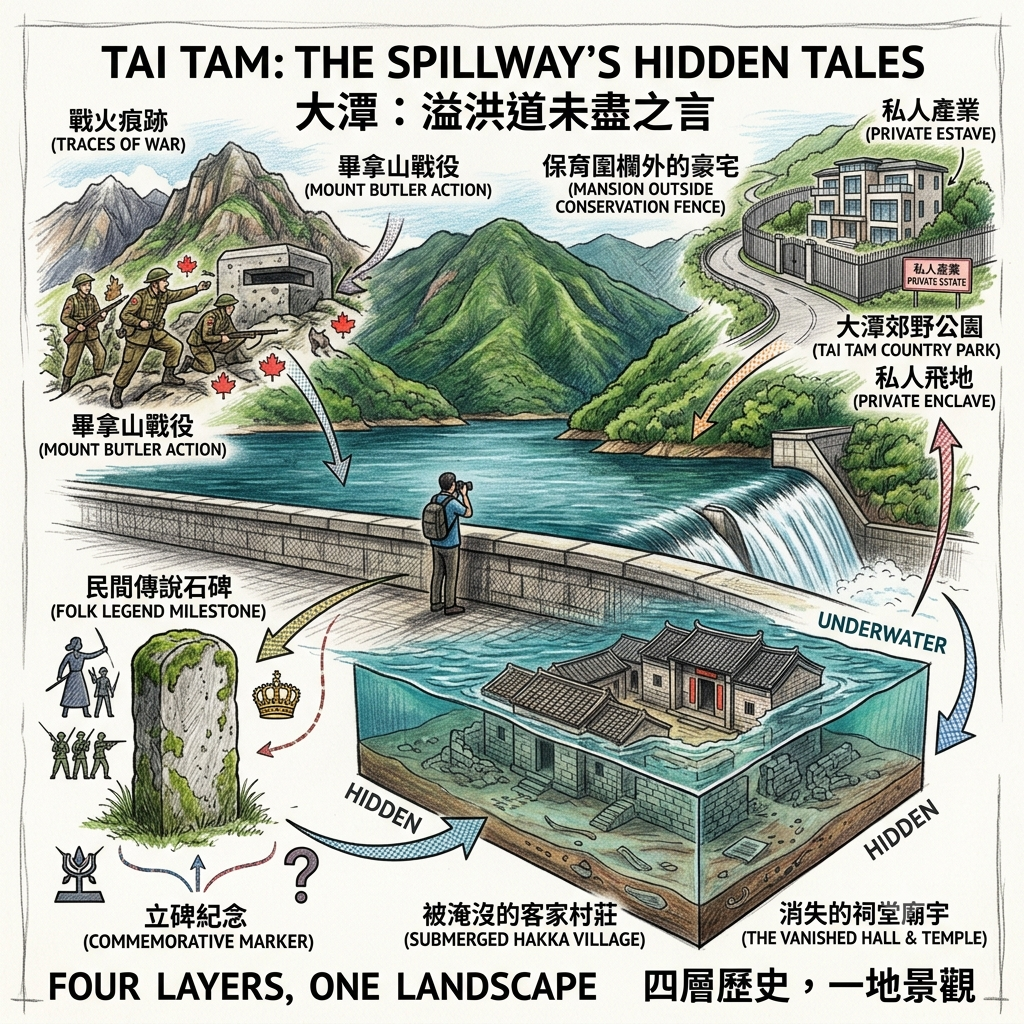
This is a deep historical travel story and walking guide to Tai Tam, a scenic reservoir area on Hong Kong Island. Moving beyond its popular reputation as a weekend "back garden," this guide explores a fence-free open-air museum through four distinct historical boundaries. Across a single valley, it uncovers the colonial myths of the "Ah Kwan" stone, the forgotten Hakka village submerged beneath the reservoir, the abandoned WWII bunkers of the East Brigade, and the modern conservation tensions surrounding the luxury estate of Hong Kong Parkview.
There is a particular kind of silence that settles over Tai Tam Reservoir on a weekday morning, before the first minibus disgorges its hikers at the country park gate. The water sits flat and granite-grey under the dam wall, and if you stand on the spillway long enough, you start to notice that the silence is not empty. It is layered — the way sediment is layered, in bands you can't see until someone cuts a cross-section through the hill.
Most people who walk this valley are looking for one thing: the postcard. The arched stone bridges, the Edwardian dam, the green water against granite — it photographs beautifully, and Instagram has decided this is "secret Hong Kong," a green lung tucked behind Stanley and Repulse Bay. That image isn't wrong. It's just incomplete, in the way a single core sample is incomplete — it tells you what's at the surface, not what's underneath.
This essay is an attempt to walk through four of those underneath layers: a colonial founding myth that got printed on a flag, a Hakka village that vanished under nine million cubic metres of water, a war that was lost on a hillside fifteen minutes from the dam, and a private housing estate that somehow ended up fenced inside land that was supposed to be unbuildable. None of these layers know about each other. They were laid down by different people, for different reasons, decades or centuries apart. But they sit in the same valley, and you walk through all four whether you notice them or not.
Listen to the historical stories told in detail (For subscribers only)
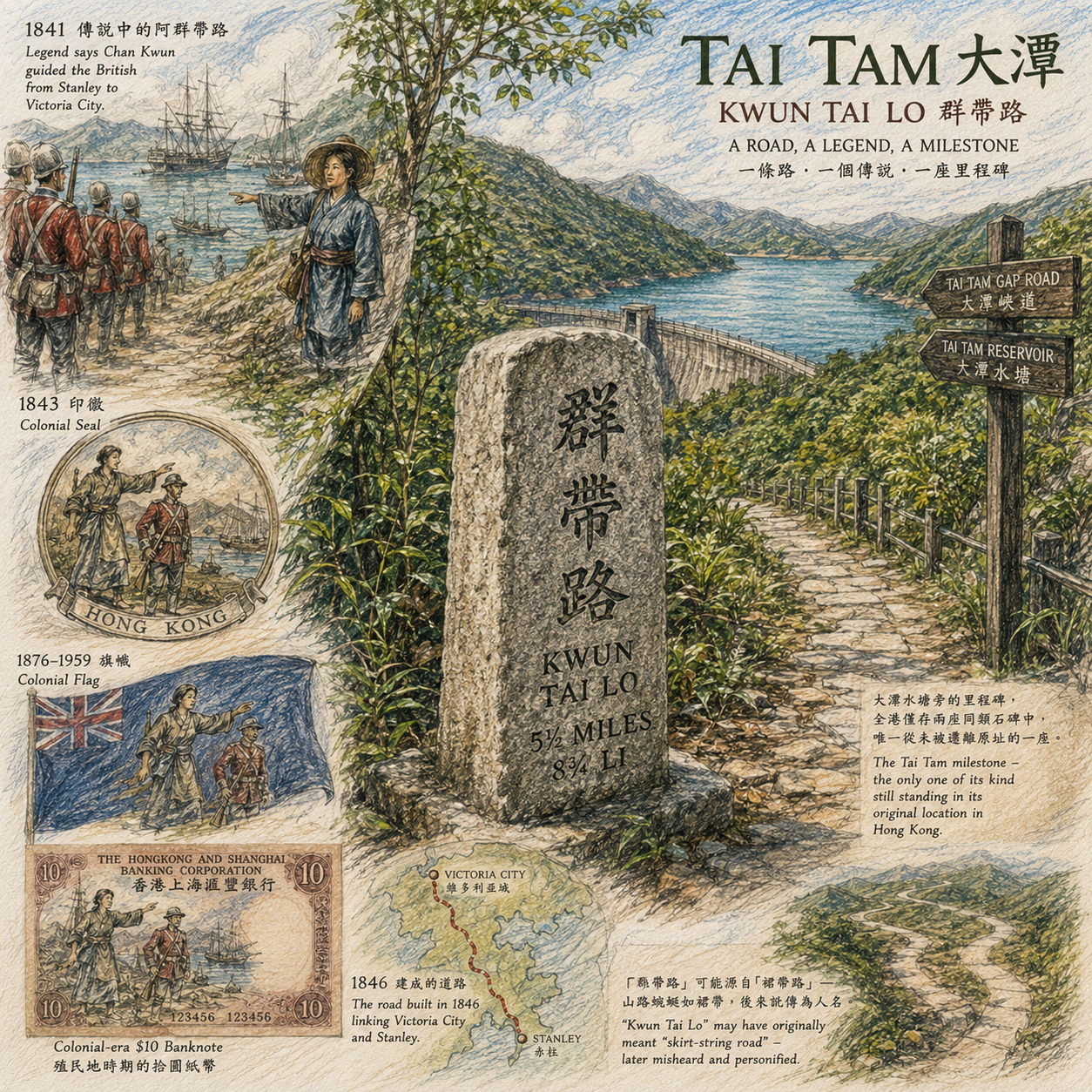
I. The Woman Who May Never Have Existed
Somewhere along the path near Tai Tam's intermediate reservoir, half-hidden by undergrowth, stands a granite milestone with three Chinese characters cut into its face: Kwun Tai Lo — "the road Kwun led the way along." Most hiking guides mention it in a single sentence, somewhere between the directions to the next car park and a reminder to bring water. It deserves more than that, because it is, quite literally, where Hong Kong's official origin story was carved into stone — and then quietly walked back by historians a century later.
The story goes like this: in 1841, when British forces first landed on Hong Kong Island, they were guided over the hills from Stanley to what would become Victoria City by a local boatwoman named Chan Kwun — "Ah Kwun." Supposedly, when the soldiers asked her the name of a village they passed, she answered in her Tanka boat-people accent, and the British transcribed what they heard as "Hong Kong." It is one of several competing explanations for the territory's English name, and almost certainly the most romantic one.
A colony, like any new institution, needs an origin story it can live with. A guide who appears out of nowhere to lead the soldiers safely home is a far more comfortable story than the alternative — that there was no guide, only a survey map and a garrison.
In 1846, the colonial government built a road following this supposed route, connecting Victoria City to Stanley, and planted granite milestones along it marking the distance in both English miles and Chinese li. One of those milestones — the one near Tai Tam — has never been moved from its original spot, which makes it one of only two such markers known to survive (the other was unearthed from the wall of a stone house in Aberdeen in 1967 and now sits in a glass case at the Hong Kong Museum of History). And here is the detail that should make you pause: by 1843, an image of "Ah Kwun leading the way" had been worked into the colony's official seal. By 1876, it appeared on the colonial flag. It stayed there until 1959, when it was finally replaced by the heraldic shield most people now associate with old Hong Kong. The same image later turned up printed on the colonial-era ten-dollar banknote.
A folk legend of uncertain authorship, about a woman whose existence no archival document confirms, ended up as state iconography for over a century.
The Hong Kong historian Leung To offered a more prosaic explanation: the road's name might originally have been "skirt-string road" — a description of how the path wound around the hillside like a woman's skirt cord — later corrupted in transliteration into something that sounded like a personal name. To complicate things further, 1841 population records list a small fishing hamlet of about fifty people near today's Causeway Bay under a near-identical name, entirely unconnected to the mountain road. Two separate place-names, two separate folk explanations, slowly fused into one tidy founding myth.
None of this means Chan Kwun didn't exist. It means we don't know, and the people who turned her into a flag emblem didn't seem especially interested in finding out. What we can verify is the road and the milestone — what we cannot verify is the woman who supposedly gave it her name, and that gap between verified infrastructure and unverifiable biography is, in miniature, how most colonial founding myths are built.
Hidden gem: the Tai Tam milestone is the only one of its kind still standing in its original location anywhere in Hong Kong — a fact that almost no hiking guide bothers to mention, because a stationary rock is a hard sell next to a waterfall.
II. The Village Under the Spillway
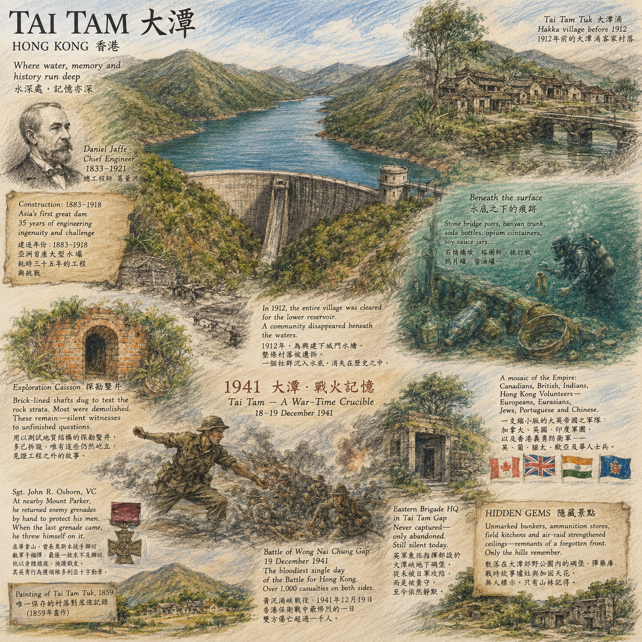
Every account of Tai Tam Reservoir tells the same engineering story, and it's a genuinely good one: a thirty-five-year construction project, from 1883 to 1918, that eventually produced what was called "Asia's first great dam." The engineers originally wanted to build the main dam directly across the mouth of Tai Tam Bay, which would have made it the first reservoir in Asia built partly over open sea — fifty years before Plover Cove attempted something similar. Wave action made that impossible, so the dam retreated inland and was built twice as tall to make up the lost capacity. The chief engineer, Daniel Jaffe, died three years after the dam's completion in 1918; Jaffe Road in Wan Chai still carries his name.
It is a story engineers tell well, because it's a story about engineers.
What it leaves out is what was standing on the site before construction began: a Hakka village, established sometime in the late eighteenth century by settlers from Meizhou and Wuhua in Guangdong, named Tai Tam Tuk. By the 1911 census it had 52 men and 24 women, three-quarters of them surnamed Chung — a single-lineage settlement with an ancestral hall, a Tin Hau temple, and a wooden bridge. When construction began on the lower reservoir in 1912, the entire village had to be cleared. It was the first time in Hong Kong's history that a reservoir project required the complete submersion of a settled village, not merely the resumption of farmland.
Engineering reports record concrete tonnage to the decimal place. They are far less precise about what happens to the people standing in the way of the concrete.
Government records show roughly HK$5,800 spent resettling villagers, most of whom relocated to Chai Wan. Whether that sum was adequate, or whether the relocation was genuinely voluntary, is not something the surviving paperwork answers clearly — the original correspondence between the District Office and the affected families, if it still exists in full, has not been comprehensively published, and remains a real gap in the historical record rather than a settled question.
What we do have is more recent and more physical. Since 2012, a team led by Dr Calvin Pang of the University of Hong Kong has conducted underwater surveys of the reservoir bed, locating what may be the remains of stone bridge piers and a remarkably intact banyan trunk, along with torpedo-shaped soda bottles, opium-paste containers, and soy sauce jars — the debris of daily life among the construction workers and possibly the displaced villagers themselves. They have never located the houses. The working theory is that the mud-brick structures simply dissolved over a century underwater. A painting survives from 1859, before construction began, showing the hillside and settlement intact — the only visual record of what the valley looked like before it became a reservoir.
The unsettling part of this story isn't that a village was flooded. Villages get displaced by infrastructure all over the world, and not always unjustly. What's unsettling is how thin the documentary trail is — how a community's disappearance left less paper behind than the dam's spillway specifications, and how reconstructing even a partial picture of it now requires divers and oral historians rather than archivists, because the archive itself barely noticed they were gone.
Hidden gem: scattered through the reservoir catchment are several brick-lined "exploration caissons" — hand-dug shafts used to test the rock strata before construction, normally demolished once a project is complete. These ones, for reasons nobody has fully explained, were left standing. They are, in a quiet way, the only unfinished business the engineers ever left visible above ground.
III. The Bunker That Was Never Attacked
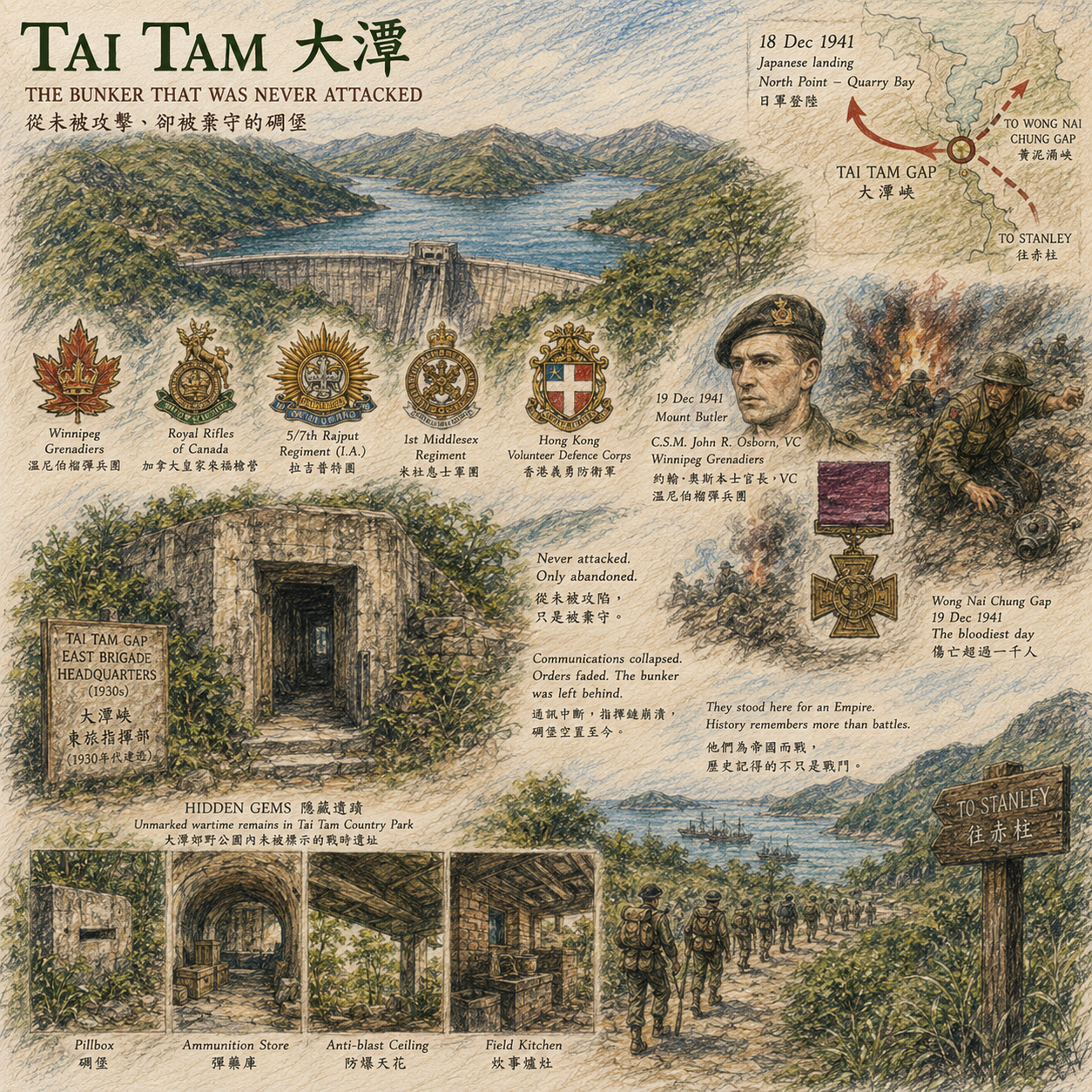
On the night of 18 December 1941, Japanese forces landed along the North Point and Quarry Bay shoreline and pushed inland, aiming to cut the British defenders' East Brigade off from the West Brigade before either could regroup. Tai Tam sat directly across that intended line of severance.
The troops defending this stretch of hillside were, on paper, a small cross-section of the British Empire's manpower: the Winnipeg Grenadiers and the Royal Rifles of Canada, the 5/7th Rajput Regiment of the British Indian Army, the 1st Middlesex Regiment, and the Hong Kong Volunteer Defence Corps — a locally raised force drawing on British, Portuguese, Jewish, Eurasian, and Chinese residents of the colony. On 19 December, on Mount Butler, within sight of the reservoir, Company Sergeant Major John Osborn of the Winnipeg Grenadiers threw back several Japanese grenades to protect the men around him, then smothered a final grenade with his own body when there was no time to throw it clear. He was killed instantly and posthumously awarded the Victoria Cross. The same day's fighting at Wong Nai Chung Gap is generally regarded as the single bloodiest day of the entire campaign, with combined casualties exceeding a thousand men.
The bunker at Tai Tam Gap was never stormed. It was simply abandoned, in the gap between one order and the silence that followed it.
The East Brigade's command post — an underground bunker at Tai Tam Gap, built in the 1930s as a fortress plotting room — was never directly attacked. Communications had broken down by the time word arrived that the West Brigade's headquarters at Wong Nai Chung Gap had fallen; the East Brigade withdrew toward Stanley, and the bunker was left standing, empty, its concrete intact, because there was no longer a battle to command from inside it.
It's tempting to flatten this into one of two familiar shapes: heroic last stand, or inevitable colonial collapse. Both miss something more specific and more interesting, which is the question of who exactly was being asked to die for Hong Kong, and why. Canada's "C Force" was largely composed of soldiers with minimal combat training, sent partly as a political gesture of imperial solidarity. The Indian Army's presence reflected decades of British reliance on South Asian troops to garrison territories the metropole had no intention of staffing with its own citizens. The Volunteer Defence Corps' multi-ethnic membership was a direct snapshot of the colony's social stratification, reorganised — briefly, urgently — into a single chain of command. After the war, Canadian veterans spent decades negotiating with their own government over the treatment and compensation of Hong Kong prisoners of war, a dispute that outlived most of the men who fought here. What's buried in this hillside isn't just a battle. It's an unresolved argument about imperial debt that, in some form, is still being had.
Hidden gem: the country park still holds unmarked pillboxes, ammunition stores, and wartime field kitchens scattered through the undergrowth, several with their anti-blast concrete ceilings intact. None of them carry an interpretive sign. Most hikers walk past them assuming they're drainage infrastructure.
IV. The Mansion Inside the Fence
In 1976, the colonial government passed the Country Parks Ordinance, and the following year designated Tai Tam as one of the first five legally protected country parks in Hong Kong — a genuine shift in how the colony's land was governed, away from the older logic of resource extraction (water catchment, military use) and toward something closer to public conservation.
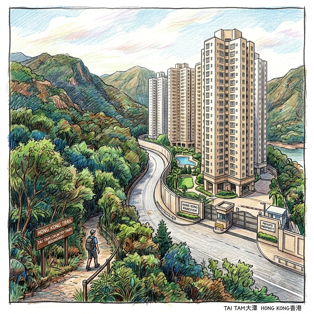
In 1981, a businessman named Wong Chau-shuen, in partnership with a bank, began construction of a luxury residential estate — Hong Kong Parkview — on a site between Jardine's Lookout and Violet Hill, surrounded on three sides by the newly designated Tai Tam Country Park and bordered on the fourth by Wong Nai Chung Reservoir Park. Eighteen towers, completed in stages between 1988 and 1989, sit at nearly 300 metres above sea level, making it one of the highest-altitude residential developments in Hong Kong.
A conservation boundary drawn on a map is not the same thing as a conservation boundary drawn on a land title. The map can be perfectly continuous. The ownership underneath it rarely is.
What's not entirely clear from the public record is the sequence of events: whether the land grant predated the park's designation, leaving a private holding inside what later became protected territory, or whether some other planning mechanism permitted construction afterward. That distinction matters enormously for how you read this story, and it is exactly the kind of detail that deserves a proper search through Lands Department and Town Planning Board archives rather than a confident assertion either way.
What is clear is the shape of the outcome: a stretch of land technically excluded from a country park's legal protections, sitting almost entirely inside its physical boundary, occupied by one of the most exclusive and private addresses in Hong Kong. This is not a uniquely Hong Kong phenomenon — Yangmingshan National Park in Taiwan has its own long-running disputes over private land enclosed within park boundaries — which suggests something structural rather than incidental: conservation legislation, almost everywhere, tends to respect pre-existing private title rather than retroactively seize it, which means a map's "protected area" is often a more honest description of scenery than of ownership.
Today, walking the section of the Hong Kong Trail or Wilson Trail between Wong Nai Chung Reservoir Park and Tai Tam Reservoir, you pass directly along Parkview's perimeter road. On one side: protected secondary forest and a public catchment area. On the other: a private clubhouse, a swimming pool, and security gates. The distance between the two is the width of a road.
Hidden gem: you cannot enter Parkview itself, but the perimeter walk is worth slowing down for in its own right — it's one of the few stretches in Hong Kong where two entirely opposed land-use philosophies, public conservation and private capital, sit shoulder to shoulder with no buffer between them at all.
V. What the Spillway Doesn't Tell You
Go back to where we started: standing on the dam, photographing the spillway.
You now know that the water below you covers a vanished Hakka village whose ancestral hall and temple were never relocated, only submerged. A short walk south, a granite milestone quietly commemorates a legend that became state iconography before anyone seriously asked whether its protagonist existed. A climb up Mount Butler takes you past the spot where a Canadian sergeant major died shielding men he'd known for only a few months, defending a colony that would surrender six days later. And the road out of the reservoir passes the perimeter fence of a private estate sitting inside a public conservation boundary that was supposed to make such estates impossible.
None of these four layers were aware of each other when they were laid down. The engineers who flooded the valley weren't thinking about commemorating the village they erased. The colonial officials who put a folk legend on the flag weren't anticipating that historians would later call its premise into question. The soldiers who died at Mount Butler had no way of knowing a luxury development would eventually rise near the site of their last stand. But all four layers occupy the same five square kilometres, and you cross through every one of them on a single afternoon's walk, usually without noticing.
This is, in the end, probably true of most landscapes that get marketed as "unspoiled" or "secret" — the unspoiled-ness is itself a kind of editorial choice, a decision about which layer of the sediment to leave exposed and which to leave buried. Tai Tam isn't unusual in being layered. It's only unusual in how legible the layers still are, if you're willing to read past the postcard.
Next time you're at the dam wall, maybe don't ask whether the view is beautiful. Ask what it replaced.
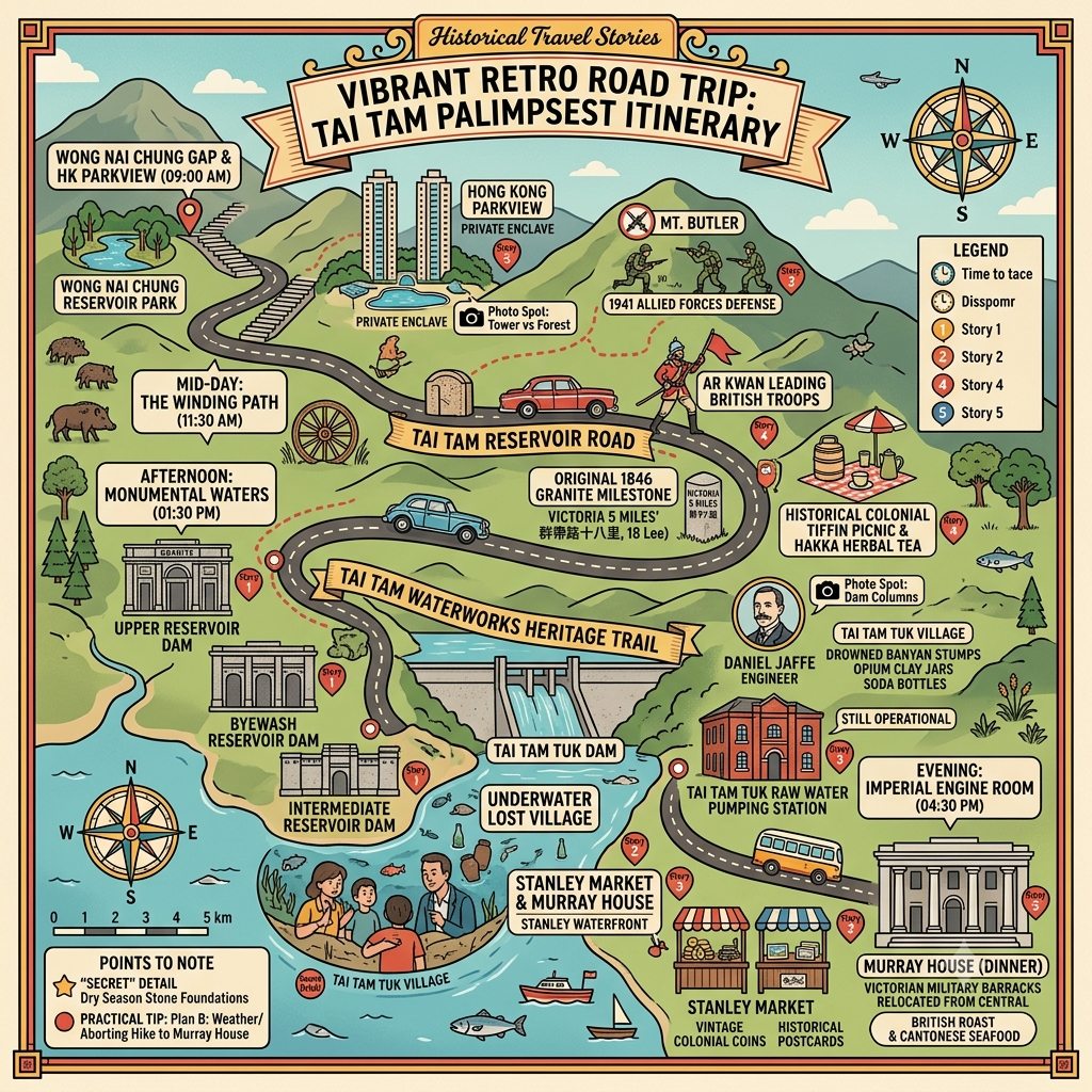
Practical Information for Visitors
Getting there: Take New World First Bus 14 from Sai Wan Ho and alight at "Tai Tam Reservoir (North)," beginning at Tai Tam Tuk Reservoir and walking the Waterworks Heritage Trail toward Tai Tam Intermediate Reservoir. Alternatively, from Central, take Citybus 6 or NWFB 66 and alight at Wong Nai Chung Reservoir Park, walking along Tai Tam Reservoir Road past Hong Kong Parkview into the reservoir area.
Suggested route: The Tai Tam Waterworks Heritage Trail runs approximately 5 kilometres and takes about two hours on largely flat terrain, suitable for casual walkers. If you want to also visit the Kwun Tai Lo milestone and the wartime remains near Tai Tam Gap, allow half a day and wear proper walking shoes.
Practical notes: Swimming and any water-contaminating activity is prohibited throughout the catchment area, including the now-closed pools below Tam Kong Waterfall. Several wartime bunkers have deteriorated structurally — view them from the exterior only, and do not enter. Hong Kong Parkview is private property; please remain on the public perimeter road and respect residents' privacy.
Best time to visit: November through February offers the driest, most comfortable conditions for extended walking. Shortly after the rainy season, the Tai Tam Tuk dam's spillways are at their most dramatic, though trails can be slippery — watch your footing.
Reference and Further reading
First layer – Main sources of literature and institutions:
- 香港水務署(Water Supply Department, HKSAR)——〈大潭水務文物徑〉官方資料及《Milestones and Waterworks Monuments》歷史里程紀錄
- 古物古蹟辦事處/文物保育專員辦事處——大潭水塘群法定古蹟(2009年公告)官方說明
- 香港大學(新聞稿)——大潭篤水塘建成百年研究發布資料(建築學院房地產及建設系潘新華博士團隊)
- 香港大學新聞稿——〈大潭篤水塘落成一百周年 港大學者重塑當年「亞洲第一壩」建築面貌〉,含遷村賠償文獻紀錄之說明
- 香港大學圖書館——《人與水壩》大潭篤水塘百年歷史展覽文物紀錄
- 香港浸會大學圖書館——「香港保衛戰1941」數碼資料庫(黃泥涌峽戰役檔案)
- 加拿大退伍軍人事務部及香港退伍軍人協會(Hong Kong Veterans Commemorative Association)相關官方歷史紀錄(建議進一步查證其具體檔案文件)
- 香港歷史博物館——館藏「群帶路」花崗石里程碑(原立於石排灣道,1967年發現出土)之文物說明
- 發展局局長網誌(香港特別行政區政府)——大潭水務文物徑導覽紀錄,含水務署工程師對大潭水塘旁「群帶路」里程碑之說明
- 漁農自然保育署(AFCD)——大潭郊野公園及其鰂魚涌擴建部分之法定劃定公告及邊界資料
- 地政總署/城市規劃委員會——陽明山莊土地批租及規劃許可相關歷史檔案(建議進一步查證具體批租文件以核實土地行政程序)
The second layer – secondary academic materials:
- 有關香港殖民地時期水務工程史與公共衛生政策關係之學術論著(建議查核香港大學建築學院、香港中文大學歷史系相關期刊論文,進一步查證原始檔案)
- 比較殖民地工程史研究(如大英帝國公共衛生與基建史相關專著),建議進一步查證原始檔案以確認具體比較文獻
- 許舒(James Hayes)有關香港島及新界鄉村社會史之研究著作與口述歷史訪談紀錄(許舒長期從事香港鄉村史與理民府制度研究,建議進一步查證其具體著作篇章以核實大潭篤村訪談內容)
- 潘新華(Calvin S.W. Pang)香港大學建築學院房地產及建設系——大潭篤水塘建築史與水底考古研究(建議查核其學術發表全文以核實考古細節)
- Tony Banham, Not the Slightest Chance: The Defence of Hong Kong, 1941(Hong Kong University Press)——香港保衛戰軍事史權威專著
- Oliver Lindsay, The Lasting Honour: The Fall of Hong Kong, 1941 ——英方視角之戰役史研究
- 梁濤有關香港地名考證及掌故研究之著作(建議進一步查證具體書目,如其香港地名考釋相關專著,以核實「裙帶路」訛轉說之原始論證)
- 1866年《新安縣全圖》及1874年桂文燦編《廣東圖說》(同治刊本)有關「群帶路」地理位置之歷史地圖文獻記載
- 香港郊野公園制度史相關研究(《郊野公園條例》立法背景及麥理浩時期保育政策研究),建議進一步查證香港大學或香港中文大學地理系、城市規劃學系相關學術論文
- 比較保育治理研究中有關「保護區內私有產權飛地」現象之文獻(如台灣陽明山國家公園私有土地爭議案例),可作跨地區比較參照
Third layer – Supplementary information:
- 香港中文報章對大潭篤水塘百年研究展覽(《人與水壩》展覽,香港大學圖書館,2018年)之報導,含工程細節與口述歷史線索
- 香港中文媒體報導(《香港01》、《經濟日報TOPick》)有關水底考古發現及口述歷史線索之長篇報導,記錄了潘新華團隊與許舒之研究互動細節
- Pillbox Study Group(英國軍事遺跡研究組織)有關黃泥涌峽及大潭峽防禦工事之田野考察紀錄
- 戰時及戰後媒體報導與退伍軍人口述歷史紀錄(建議進一步查證個別口述歷史檔案之原始出處)
- 香港歷史掌故網站及中文媒體(如「港識多史」)有關「阿群帶路」傳說多重版本之整理報導
- 1841年《中國叢報》(The Chinese Repository)港島人口紀錄中有關「裙大路」(東角漁村)人口數據之轉引報導,建議進一步查證原始期刊文獻
- 中文媒體及地產資訊網站有關陽明山莊發展商背景、建築規模及住戶構成之報導整理
- 行山及郊遊路線指南中有關陽明山莊與大潭郊野公園地理關係之描述性記錄


This piece draws on an extended historical research dossier prepared for in-depth travel and history coverage. Readers with further interest in any of the five episodes are encouraged to consult primary sources directly — several details, particularly around the wartime occupation period, remain genuinely contested in the scholarly literature.