(ENG) The Palimpsest of the South: Deciphering the Layers of Wenshan, Taipei


How did Wenshan transform from a coal mining hub to modern residential space?
What are the spiritual history of the three major Jiying Temple branches?
How did water engineering and Tieguanyin tea shape the region's early economy?
Wenshan District, the historic "Wenshan Fort," serves as the southern gateway to the Taipei Basin—a landscape where the Jingmei Creek carves a narrative through narrow plains and rolling hills. To the casual observer, it is a quiet residential enclave, but for the urban morphologist, the district’s history is found underfoot. The streets are not merely paths; they are residual patterns of vanished water and industry. Wenshan represents a frontier of resources—water, tea, coal, and political ideology—where each era has left a physical signature. This article invites the reader to look beneath the surface, revealing the spatial logic of power, technology, and migration that transformed a Qing-dynasty wilderness into a vital node of modern Taiwanese identity.
The journey into Wenshan’s past begins with the fundamental element that made settlement possible: the flow of water and the engineering required to master it.

Listen to the historical stories told in detail (For subscribers only)
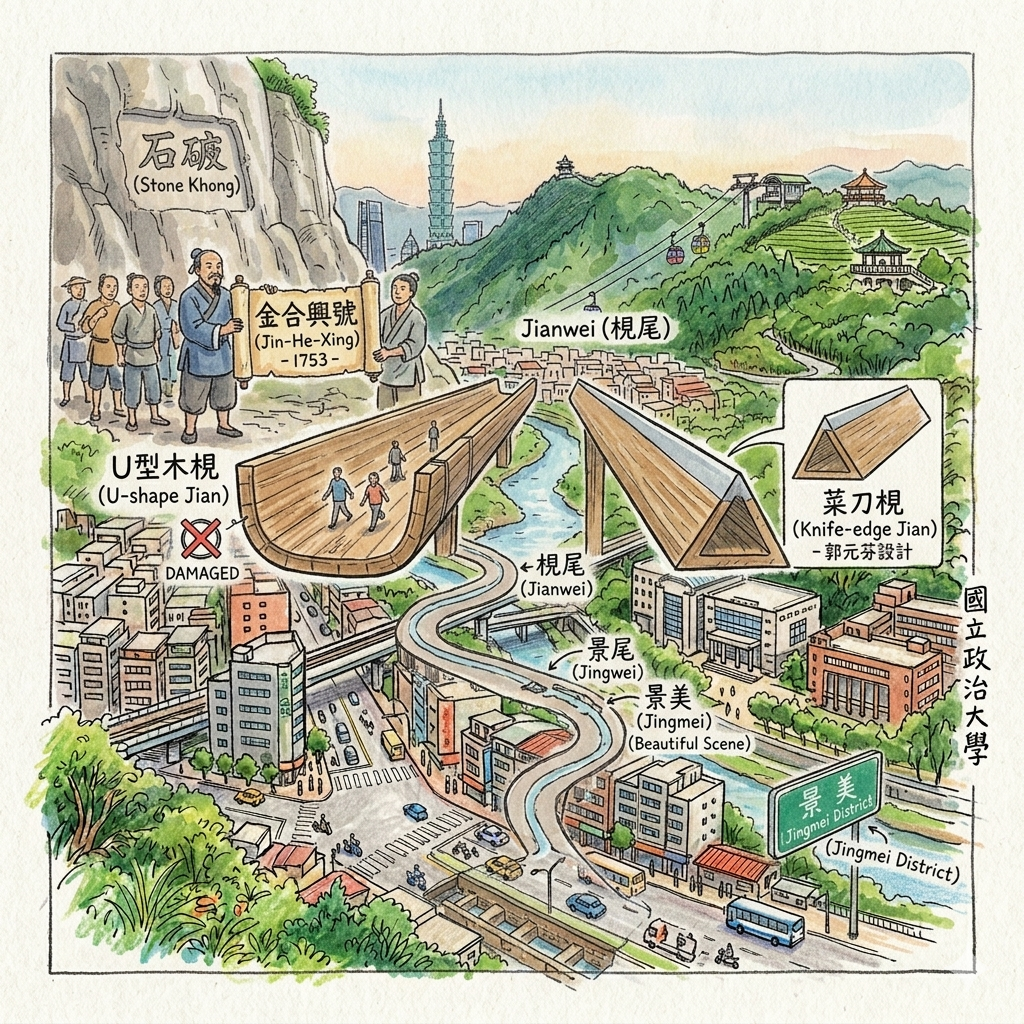
The Engineering of "Jianwei": From Troughs to Townships
In the mid-18th century, the transformation of Wenshan began with the Liu-Gong Canal, a high-stakes gamble in hydraulic management spearheaded by Guo Xi-liu. This project was more than a technical feat; it required a 1753 formal agreement known as the "Jin-He-Xing" (金合興號) to ensure mutual defense and resource sharing between rival settler groups.
The Engineering of Troughs
To transport water across the low-lying Jingmei Creek without modern pressure pipes, engineers designed massive U-shaped wooden troughs, or "Jian." The settlement that grew at the terminus where the water entered the plain was named "Jianwei"—literally "Trough-end."
The Knife-Edge Strategy
The design of these troughs underwent a critical evolution from the U-shape to the "Knife-edge" (菜刀梘). This was a sophisticated spatial management strategy: the triangular, sharpened top prevented residents from using the troughs as a bridge, a common practice that had previously led to structural damage. It was engineering as a form of social control.
"So What?"
The evolution of the name from the functional "Jianwei" to the Japanese "Jingwei" and finally to the aesthetic "Jingmei" ("Beautiful Scene") in 1950 represents a shift in civic identity. It marks the transition of a society viewing its landscape through the lens of raw utility toward one that seeks to "civilize" its surroundings. Today, the canal exists as a "spatial negative" in the winding, organic curves of Jingmei’s old streets, which still follow the vanished water path.
"The 1753 agreement (Jin-He-Xing) enabled the carving of the 'Stone Khong'... providing a gravity-fed lifeline that transformed 'rain-fed fields' into a scalable agricultural powerhouse."
As the water stabilized the land, the families who settled here sought spiritual and social structures to govern their new territory, mapping the district through faith.
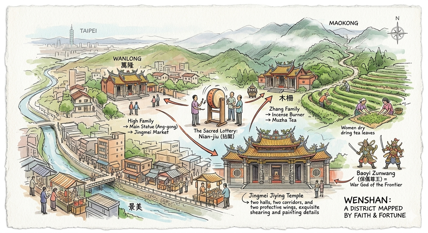
The Sacred Lottery: How Three Families Mapped a District
The development of Wenshan is inseparable from the history of Anxi immigrants, specifically the High, Lin, and Zhang families. In the early days of settlement, these groups operated under a model of "common cultivation" to survive the frontier. As the population expanded, they used a unique mechanism to distribute their shared ancestral deity artifacts: a lottery known as "Nian-jiu."
The "Nian-jiu" Distribution
The results of this lottery dictated the spatial and economic layout of the district: the High family drew the main statue of "Ang-gong" and established themselves in Jingmei; the Lin family drew the statue of the deity’s wife and settled in Wanlong; the Zhang family drew the porcelain incense burner and moved to the Muzha highlands.
Economic Specialization
This lottery was a "spatial investment strategy" that led to a sophisticated division of labor. The High family in the lowlands of Jingmei focused on commercial trade and market development, while the Zhang family in the hills of Muzha dedicated themselves to the tea industry.
"So What?"
The deity "Baoyi Zunwang" was transformed by this geography. Originally an agricultural protector, he became a "war god" against the dangers of the frontier. The resulting "Cultural Triangle" of Jiying Temples in Jingmei, Wanlong, and Muzha still defines the social geography of Wenshan today, serving as a reminder of how religious lotteries dictated the specialization of entire neighborhoods.
As the ancestral shrines anchored the valley floor, the economic gaze of the district shifted upward toward the mist-shrouded peaks of Maokong.
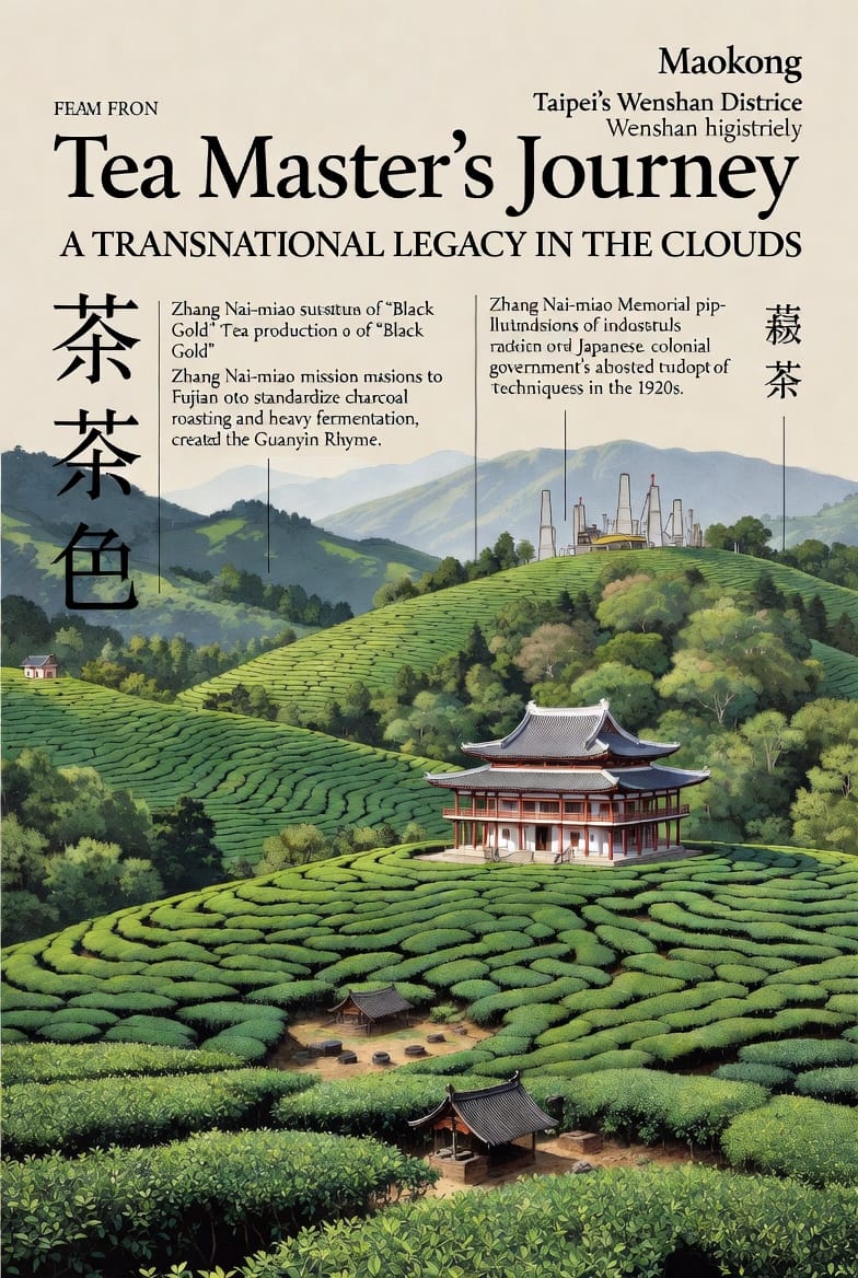
The Tea Master’s Journey: A Transnational Legacy in the Clouds
The Maokong highlands are often viewed today as a site of leisure, but historically, they were a site of intense technological innovation. In the late 19th century, tea master Zhang Nai-miao undertook missions to Fujian to bring back Tieguanyin seedlings to Muzha.
Transnational Technology Transfer
Zhang’s contribution was not merely the plant, but the standardization of "charcoal roasting" and "heavy fermentation." This created the "Guanyin Rhyme," a brand identity that allowed Muzha tea to remain competitive across shifting political borders, from the Qing dynasty through Japanese colonial rule.
The Industrialization of the Hills
By the 1920s, the Japanese colonial government officially integrated Zhang’s traditional methods into the state’s agricultural bureaucracy. Visitors to the Zhang Nai-miao Memorial Hall can still observe the traditional roasting pits—the physical infrastructure of a 19th-century technological revolution.
"So What?"
The success of Tieguanyin illustrates how kinship networks maintained industrial competitiveness despite regime changes. It transformed the rugged slopes into a professionalized landscape, proving that even "traditional" crafts are the result of deliberate, transnational technology transfers.
Beneath these lush tea hills, however, lay a darker, more literal treasure: the industrial substratum of "Black Gold."
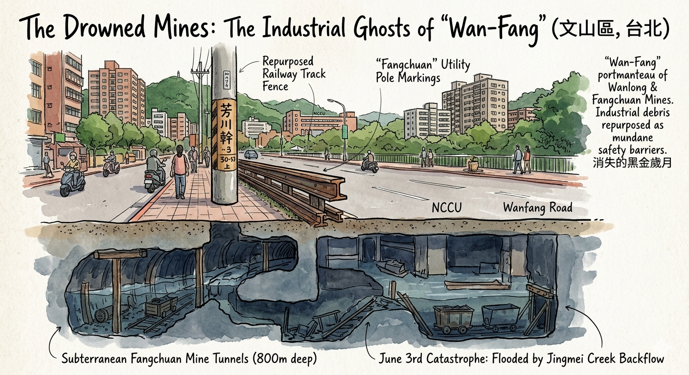
The Drowned Mines: The Industrial Ghosts of "Wan-Fang"
During Taiwan’s post-war industrialization, Wenshan was a center for coal extraction. The Fangchuan Mine was the district's titan, employing over 500 workers with tunnels that reached depths of 800 meters.
The Tunnels Beneath the University
The scale of this "invisible urbanism" is staggering; the Fangchuan mine’s tunnels actually extended beneath modern-day National Chengchi University (NCCU) and Muzha Road, creating a subterranean city that once dictated the economy above.
The June 3rd Catastrophe
This era ended abruptly on June 3, 1984. Catastrophic floods caused the Jingmei Creek to backflow into the mine shafts, "drowning" the industry overnight. The mine was permanently sealed, leaving the infrastructure to be reclaimed by the city.
"So What?"
The name "Wan-Fang" is a linguistic fossil—a portmanteau of the Wanlong and Fangchuan mines. Today, the industrial debris has been repurposed with a chilling utility: look for "Fangchuan" markings on utility poles and the old railway-track fences on Wanfang Road, where the very tracks that once hauled coal now serve as mundane safety barriers.
"The name 'Wan-Fang' serves as a permanent linguistic marker of two private industrial empires that once dictated the regional economy."
The physical dangers of the mines were eventually mirrored by the political dangers of the mid-20th century.
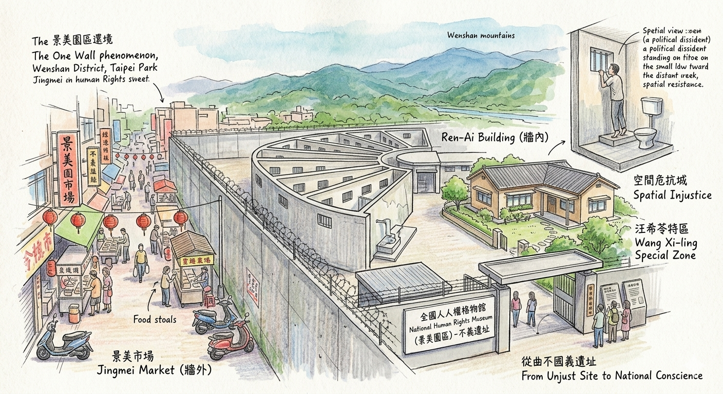
The Wall of Silence: One Mile Between Markets and Prisons
The most jarring layer of Wenshan’s history is the Jingmei Detention Center (now the National Human Rights Museum). During the White Terror, this was the highest-level military trial and detention site in Taiwan.
The Proximity of Power
The site is defined by its chilling proximity to civilian life. Only a single wall separated the bustling Jingmei market from the "Ren-Ai Building" cells. This "one wall" phenomenon placed absolute state violence within earshot of the everyday market.
Spatial Resistance and Injustice
The hierarchy of law was physically manifested here: the "Wang Xi-ling Special Zone," a comfortable villa for a high-ranking intelligence officer, stood in stark contrast to the cramped cells of dissidents. Within those cells, prisoners engaged in a desperate form of spatial resistance, standing on their toilets or bath platforms just to catch a glimpse of the mountains and the creek over the high walls.
"So What?"
The transition from an "unjust site" (不義遺址) to a National Human Rights Museum represents the district's shift from a place of state-sponsored silence to a site of national conscience. It remains a physical signature of the struggle for the democracy that Taiwan enjoys today.
Hidden Gem Recommendation
To truly grasp the "repurposed" history of Wenshan, observe the old railway fences on Wanfang Road. These are not modern guardrails but are actually salvaged tracks from the coal-hauling carts of the Fangchuan Mine. Furthermore, visit the Jingmei Jiying Temple to see the 1924 murals, which represent the peak of local craftsmanship following the "Three-Family Split."
Philosophical Synthesis & Conclusion
Wenshan is a geographic palimpsest—a landscape where the requirements of water engineering, the lotteries of faith, the technology of tea, and the struggle for human rights are layered on top of one another. To walk these streets with "layered observation" is to stop seeing the city as a static background and start seeing it as a living manuscript.
How does knowing that a winding alley was once a 1700s water trough, or that a modern street fence once hauled "black gold" from beneath a university, change your understanding of the ground you walk on? Wenshan challenges us to realize that our modern lives are built directly upon the engineering, faith, and sacrifices of those who carved this frontier.
Join our registry of observers for future inquiries into the spatial past and the hidden signatures of our cities.
Planning Your Historical Walk
How to get there: Wenshan is served by the MRT Brown Line (access to Wanfang and Muzha) and the MRT Green Line (access to Jingmei).
Recommended Accommodation: Stay near the Jingmei MRT station to be within walking distance of the night market, the Jiying Temple, and the National Human Rights Museum.
Recommended Tours:
- Human Rights Walk: A guided exploration of the National Human Rights Museum and the "unjust sites" of the White Terror.
- Tea Culture Trail: A technical look at tea production in Maokong, including the Zhang Nai-miao Memorial Hall.
Reference and Further reading
- 文山行〔5〕景美老街‧瑠公圳洵跡#01, accessed March 15, 2026,
- 瑠公圳- accessed March 15, 2026,
- 淺山,三角湧隘勇線(1900), accessed March 15, 2026,
- 景美古地名因水圳設施而來 - 瑠公管理處, accessed March 15, 2026,
- 景美- 第十河川分署 - 水利署, accessed March 15, 2026,
- 大臺北地區地方學研究的回顧與展望*, accessed March 15, 2026,
- 文山軌道運輸與煤礦 顏文魁老師- 台北市文山社區大學, accessed March 15, 2026,
- 守護百年瑠公圳的人與屋:文化保存與居住權的爭議 - 我們的島, accessed March 15, 2026,
- 景美集應廟 - 國家文化資產網, accessed March 15, 2026,
- 景美集應廟(一)建廟歷史- 台北市文山社區大學, accessed March 15, 2026,
- 景美集應廟由來詳細介紹、起源故事與拜拜攻略-嗨放HaveFunDay, accessed March 15, 2026,
- 木柵老街的記憶 魏炳琨老師- 台北市文山社區大學, accessed March 15, 2026,
- 廟史沿革 - 景美集應廟官網, accessed March 15, 2026,
- 景美集應廟 - 臺灣宗教文化地圖, accessed March 15, 2026,
- 木柵茶葉專業農戶, accessed March 15, 2026,
- 迺妙茶話, accessed March 15, 2026,
- 台北信義區礦坑隱身城市巷弄的幽暗歷史 - wilhelm chang, accessed March 15, 2026,
- 芳川礦業- accessed March 15, 2026,
- 1000508-1文山-芳川煤礦、萬隆煤礦 - 放羊的狼, accessed March 15, 2026,
- 台北市芳川煤礦(踏查日期2004年8月7日) - 車小斌Barefoot Good, accessed March 15, 2026,
- 白色恐怖景美紀念園區- accessed March 15, 2026,
- 令人唏嘘不已的景美人權文化園區 - 這是台灣守護聯盟的網頁, accessed March 15, 2026,
- 仁愛樓- 國家人權博物館, accessed March 15, 2026,
- 國家人權博物館白色恐怖景美紀念園區 - 新北市觀光旅遊網, accessed March 15, 2026,
- 新北新店區「國家人權博物館.白色恐怖景美紀念園區」留下傷痛現場,理解一段珍貴的民主之路, accessed March 15, 2026,
- 還原白色迷霧裡的歷史拼圖人權館推出《景美看守所辦公空間復原及展示》 - 國家人權博物館, accessed March 15, 2026,
- 國家人權博物館: 首頁, accessed March 15, 2026