(ENG) The Thousand-Layered Isle: Unearthing the Secret Histories of Tung Ping Chau, Hong Kong
On the 55-million-year-old shale shores of Tung Ping Chau, Hong Kong's remote northeast island, history unfolds. From pirate raids and WWII rescue missions to Cold War escapes and global migrations, this "historical haven" reveals resilient tales of survival amidst stunning geological wonders.

INTRODUCTION: THE SILENT SENTINEL OF MIRS BAY
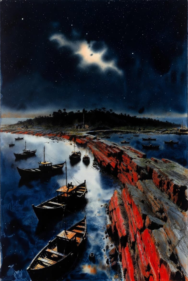
Tung Ping Chau sits as a lonely sentinel at the extreme northeast fringes of Hong Kong’s waters, closer to the mainland coast than the city’s urban core. Today, the island is a sanctuary of silence, famous for the mesmerizing horizontal layers of its 55-million-year-old sedimentary rock. However, for the walking historian, these geological formations and the island’s human history are an inseparable palimpsest; the landscape is a document where every stratigraphic line corresponds to a chapter of imperial decree or maritime struggle. To traverse its perimeter is to walk through layers of pirate wars, wartime resistance, and desperate escapes. This beauty is a mask for a brutal and resilient past. The island's story is not a mere local chronicle but a microcosm of the power struggles that shaped the South China Sea—a history written in displacement and rebirth.
Listen to the historical stories told in detail (For subscribers only)
THE VOID OF THE EMPIRE: THE GREAT CLEARANCE AND BLOODLINE REBIRTH
In the mid-17th century, Tung Ping Chau became a casualty of high-stakes imperial geopolitics. The Qing Dynasty, struggling to consolidate power against the Ming loyalist forces of Zheng Chenggong (Koxinga) in Taiwan, viewed the maritime fringes not as territory to be defended, but as a liability to be erased. Centralized imperial logic dictated that the only way to defeat a maritime enemy was to create a massive artificial void, starving rebels of resources and intelligence.
In 1661, the "Great Clearance" (遷界令) was enacted, mandating that all residents living within 30 to 50 li of the coast move inland. Tung Ping Chau fell squarely outside this "death line." The impact was immediate: homes were burned and granaries destroyed to ensure nothing remained.
"The officials in charge of the forced migration executed those who refused to go (押遷之官,遂行誅戮)."
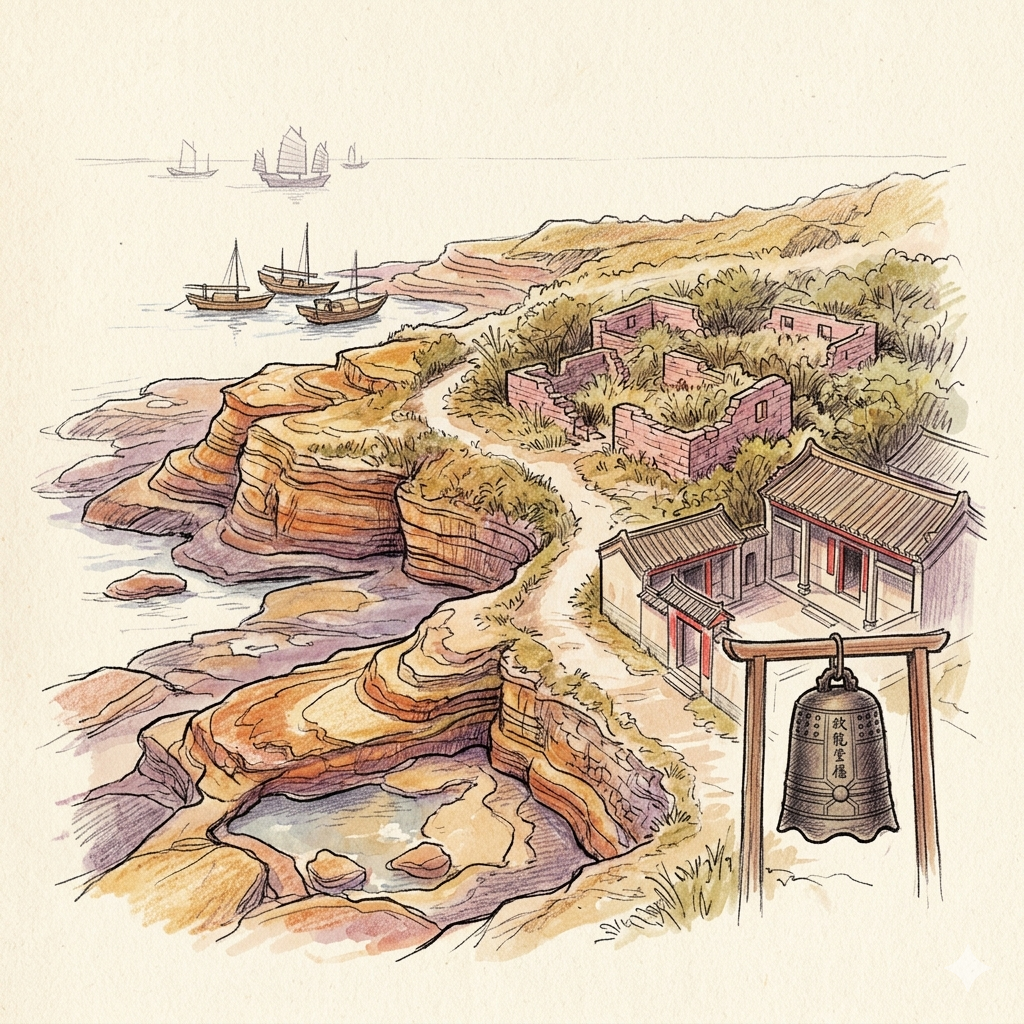
This policy permanently altered the ethnic makeup of the region, shifting it from "Punti" dominance to a Hakka-centric reconstruction. When the "re-boundary" occurred in 1669, the original inhabitants were gone. To repopulate the void, the Qing government recruited Hakka migrants, leading to the establishment of the island's five main villages: Chau Mei, Tai Tong, Sha Tau, Chau Tau, and Nai Tau. Today, the Tin Hau Temple at A Ma Wan houses a Qianlong-era bell (1765), which served as more than a religious object; it was a "political license," an artifact of legitimacy signaling that the returning settlers were officially recognized by the imperial state.

WATCHTOWERS IN THE MIST: PIRATE COEXISTENCE IN MIRS BAY
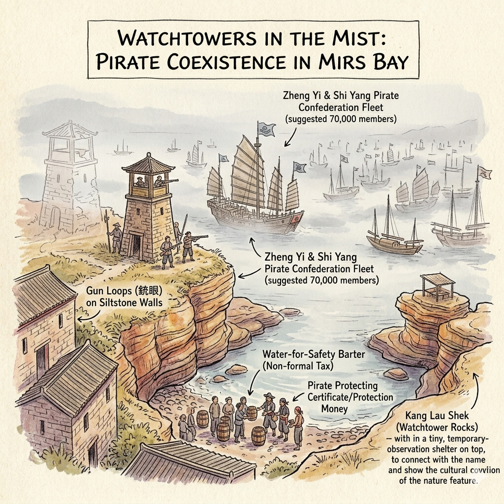
By the early 19th century, Qing authority had receded, leaving a power vacuum filled by a pirate confederation of 70,000 members led by Zheng Yi and Shi Yang. For the islanders, survival depended on navigating a "grey zone" where the state offered no protection. The relationship between the villagers and the pirates evolved into a "non-formal tax system." Because the island was chronically short of fresh water, villagers often bartered their water supplies for safety, paying protection money to avoid being pillaged.
The island’s architecture reflects this era of maritime crisis. While the famous Kang Lau Shek (更樓石) are natural sea stacks, their name—meaning "Watchtower Rocks"—reveals the collective watchtower psychology of the inhabitants. They represent a lost architectural reality; the island once featured physical, manned watchtowers (更樓) that have since collapsed. Tangible evidence of this structural defense remains in the stone houses of Tai Tong Village, where visitors can still find gun loops (銃眼)—narrow apertures high in the siltstone walls designed for firing muskets or spears at invaders.
THE SHADOW NETWORK: TUNG PING CHAU AS A WARTIME HUB
During the Japanese occupation (1941–1945), the island's flatness—usually a vulnerability—became a strategic invisibility cloak. Lacking high peaks, the island allowed boats to move at night without being silhouetted against a mountain background, transforming Tung Ping Chau into a vital node for the Hong Kong-Kowloon Independent Brigade.
The island served as a "shadow network," acting as a secret communication station and a temporary warehouse for the "Great Rescue" of cultural elites like Mao Dun and He Xiangning. The ruins once stored critical supplies—medicines, batteries, and fuel—needed for the voyage to the mainland. A key figure here was Yuan Geng (then Ouyang Rushan), a guerrilla leader who managed these clandestine logistics. His experience navigating the complex social and maritime fabric of the island later informed his role in founding the Shekou Industrial Zone, bridging the gap between wartime survival and the Reform and Opening-Up era. For these sailors, Lung Lok Shui (龍落水), a long band of siliceous rock, served as a critical navigational landmark for steering through the dark.
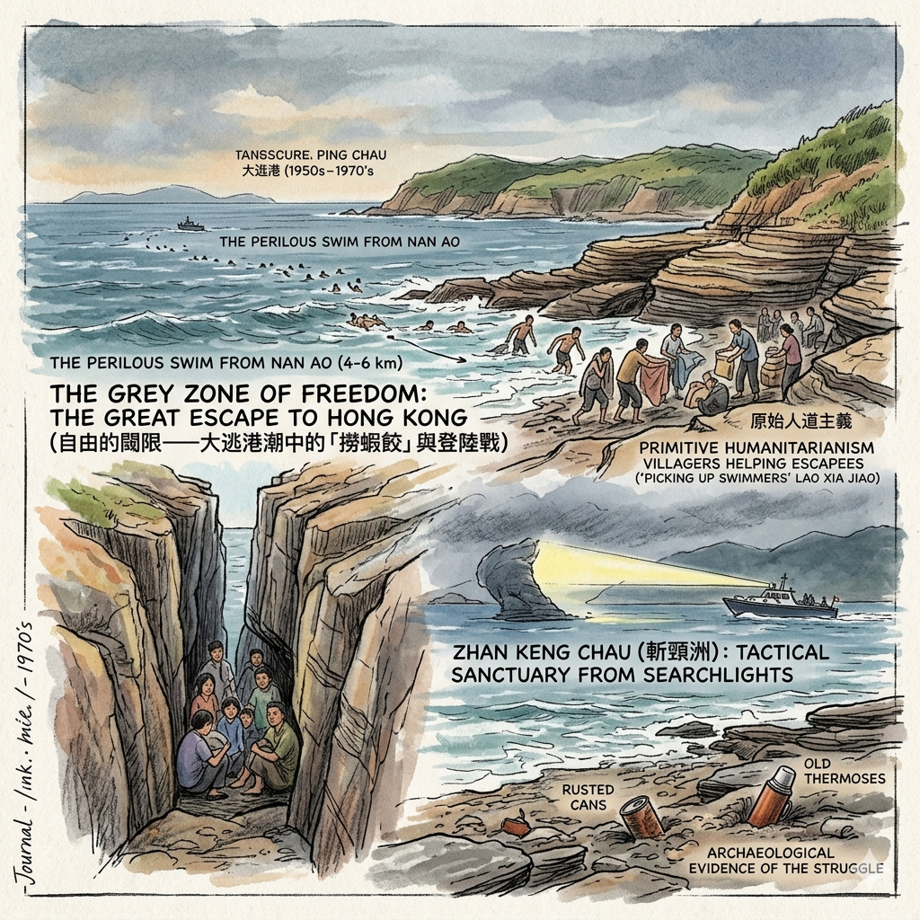
THE GREY ZONE OF FREEDOM: THE GREAT ESCAPE TO HONG KONG
From the 1950s to the 1970s, the island became the first "light of the rule of law" for those fleeing the mainland during the "Great Escape to Hong Kong" (大逃港). The 4-to-6-kilometer swim from Nan Ao was a journey of extreme peril. This period was defined by a stark moral contrast: while the mainland offered a 50 RMB reward for catching escapees—a small fortune at the time—the islanders largely chose "primitive humanitarianism."
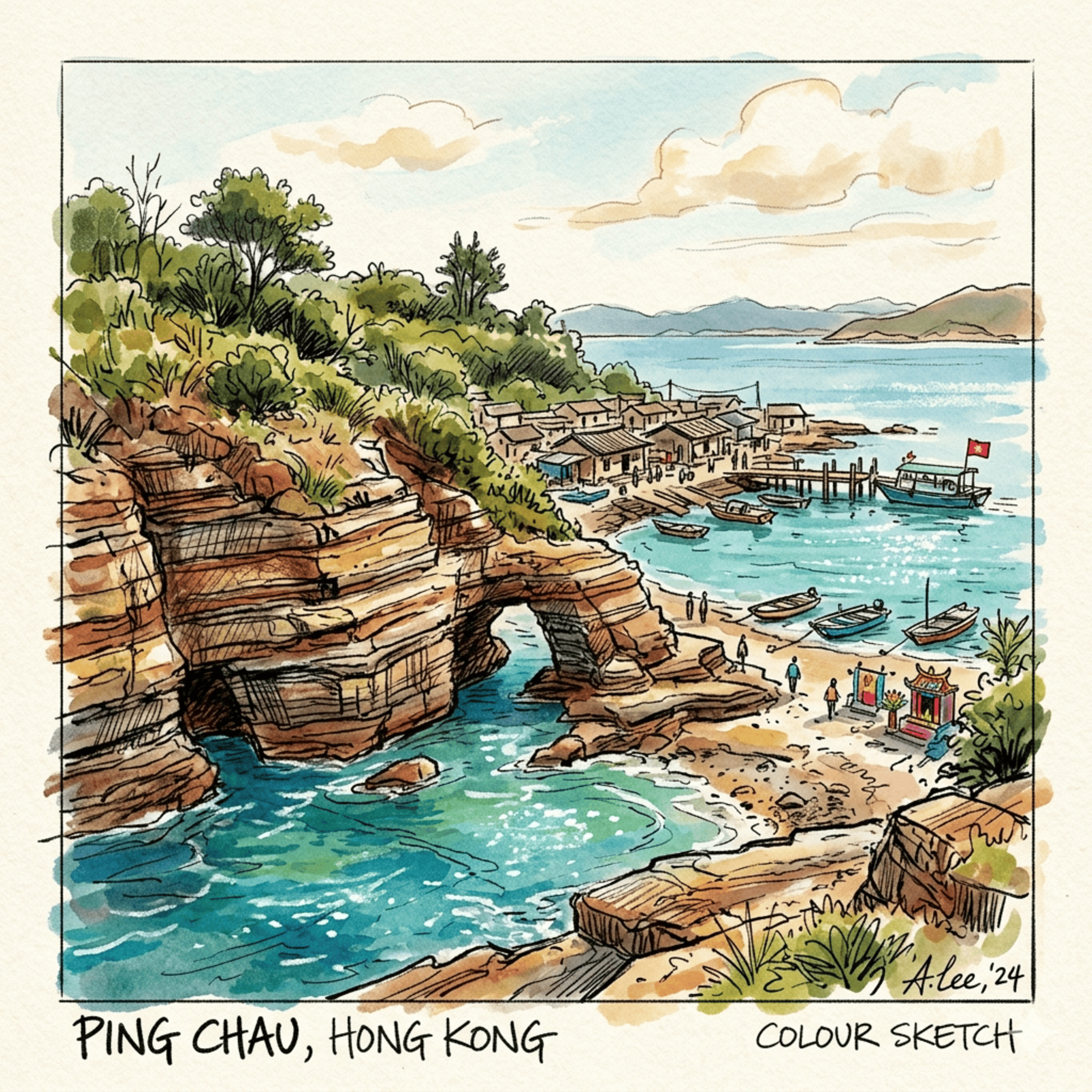
Through an informal economy known as "picking up swimmers" (lao xia jiao), villagers provided food, dry clothes, and shelter to those who washed ashore, despite the legal risks. The Zhan Keng Chau (斬頸洲) canyon, a deep and narrow cleft in the rock, became a tactical sanctuary. Its steep walls provided perfect cover for escapees to hide from the sweeping searchlights of police patrol boats as they waited for the right moment to slip toward the inner territories of Tai Po.
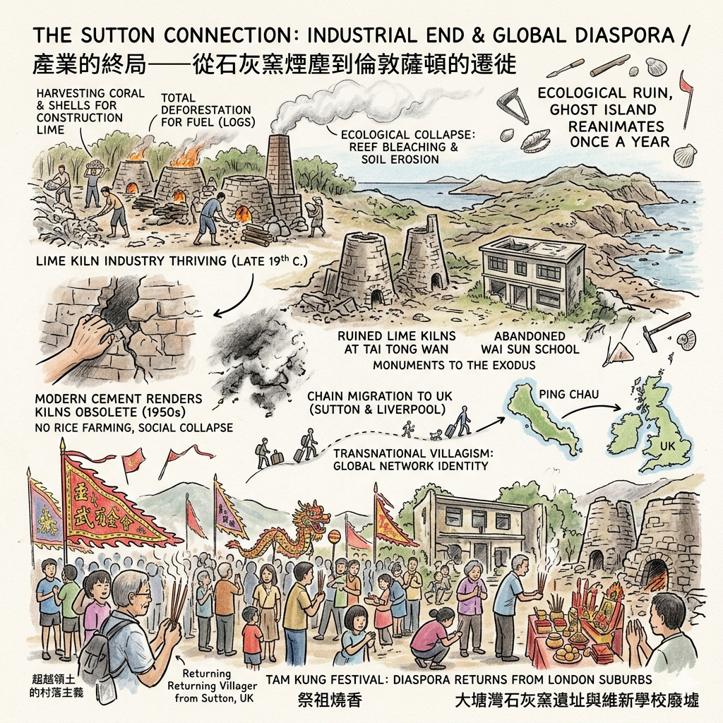
THE SUTTON CONNECTION: INDUSTRIAL END AND GLOBAL DIASPORA
The final layer of the island’s history is one of ecological collapse and global dispersion. In the late 19th century, the island thrived on the Lime Kiln industry, harvesting coral and shells from the reefs to produce construction lime. However, the kilns required massive amounts of fuel, leading to total deforestation. Without trees to retain water and with the soil stripped, the island could not sustain rice farming once the lime industry was rendered obsolete by modern cement in the 1950s.
Facing social collapse, the community began a "Chain Migration" to the United Kingdom, specifically to Sutton and Liverpool. This created a "Transnational Villagism" where the islanders’ identity is no longer tied to the land but to a global network. The ruined Lime Kilns at Tai Tong Wan and the abandoned Wai Sun School are monuments to this exodus. The "ghost island" only breathes once a year during the Tam Kung Festival, when the diaspora returns from the London suburbs to reanimate their ancestral home.
HIDDEN GEMS FOR THE HISTORICAL TRAVELER
The Abandoned Village Schools (Wai Sun & Kwan Ying) The Wai Sun School in Chau Tau and Kwan Ying School in Tai Tong stand as ghostly monuments to a lost student body. Inside these decaying structures, educational diagrams and 1970s slogans still fade on the walls. They capture the exact moment of the island’s hollowing out, where classrooms were frozen in time as the youth departed for lives across the sea.
CONCLUSION: THE LONELY SENTINEL’S LESSON
Tung Ping Chau is often called a "geological book of a thousand pages" (Qian Ye Shu), but its truest history is written in the gaps between the rocks—the spaces left by the displaced, the escaped, and the migrated. It is a narrative of resilience and the precariousness of life on the fringe. From the imperial clearances of 1661 to the global diaspora of the 1970s, the island has been repeatedly emptied and refilled by the tides of history.
As you stand on its siltstone shores, a question remains: Does a place exist in its physical ruins, or in the collective memories of a diaspora thousands of miles away? Tung Ping Chau is a silent witness to the fact that even the most remote edges of the map are etched by the struggles of the human heart.
Subscribe to Historical Travel Stories for more deep-dives into the landscapes of the past.
PLANNING YOUR JOURNEY TO THE EDGE
- How to Get There: Ferries depart from Ma Liu Shui Pier (near University MTR Station) on Saturdays, Sundays, and public holidays. The journey takes approximately 1.5 to 2 hours.
- Recommended Tours: Seek out specialized eco-historical walking tours that focus on the village ruins, lime kilns, and the "Great Rescue" routes.
- Accommodation Notes: Overnight stays are scarce. There are no hotels, only a few basic, village-run guesthouses in Tai Tong or Chau Mei. Advance booking is essential.
Q & A
Why did the entire island population eventually migrate to England?
The collective migration of Tung Ping Chau’s population to England in the 1960s was driven by a combination of economic collapse, resource depletion, and the island's geographic limitations.The primary factors behind this mass exodus include:
- Collapse of the Lime Industry: In the late 19th and early 20th centuries, the island thrived on fishing and lime production, using coral reefs and shells as raw materials. However, by the 1950s, traditional lime was replaced by the widespread use of modern cement. Additionally, the British Hong Kong government began implementing environmental protections that restricted the harvesting of coral, effectively ending the island’s economic backbone.
- Environmental and Agricultural Failure: The intensive lime industry had led to the deforestation of the island for fuel, leaving the land barren. Furthermore, the island's soil was naturally hard and suffered from extreme water scarcity, which made it impossible for residents to transition to rice cultivation or other forms of sustainable agriculture once the industrial and fishing sectors declined.
- "Chain Migration" through Clan Ties: Facing a survival crisis, the villagers utilized their strong lineage and clan organization to facilitate a "chain migration" process. Initially, able-bodied men moved to the UK as sailors or laborers; once they established a foothold, they systematically brought over the elderly and children from their respective villages.
- Collective Settlement in Sutton: This migration was so organized that the villagers almost entirely relocated to specific areas in the UK, most notably Sutton in South London and Liverpool, where they collectively entered the catering industry.
This rapid departure turned Tung Ping Chau into a "ghost island" in a very short period, leading to the closure of local institutions like the Wai Sun and Kwan Ying schools due to a total lack of students. Today, the connection remains through "transnational villageism," as descendants from Sutton return to the island annually for the Tam Kung Festival to worship their ancestors.
What was Tung Ping Chau's role in the 'Big Escape'?
During the "Big Escape" (the mass exodus from mainland China between the 1950s and 1970s), Tung Ping Chau served as a critical strategic relay station and the "first light of dawn" for thousands of refugees seeking safety in Hong Kong.The island's role was defined by the following factors:
- Geographic and Legal Gateway: Located in the center of Mirs Bay, Tung Ping Chau was the closest piece of British-governed land for those swimming from Nan Ao. Successfully reaching the island's shores meant entering British jurisdiction, which represented a transition to the rule of law and survival for refugees. Escapees often swam four to six kilometers using rudimentary flotation devices like tire inner tubes, thermoses, or wooden boards.
- Natural Cover and Hiding Spots: The island’s unique geological formations provided tactical advantages for those evading capture. Specifically, the long, narrow canyons of Zhan Keng Chau (Chop Neck Island) were used as hiding spots because they could effectively block the searchlights of water police patrol boats.
- Humanitarian Intervention by Villagers: Despite strict laws against assisting illegal immigrants, many Tung Ping Chau villagers acted out of "primitive humanitarianism" based on shared kinship and geography. They frequently provided escapees with dry clothes and food, and even coached them on how to avoid police patrols to reach the urban areas of Tai Po or Ma Liu Shui.
- The "Lao Xia Jiao" Economy: The exodus created a dark, informal economy in the waters around the island. Because the Chinese government offered a 50 RMB reward (a huge sum at the time) for capturing escapees, some fishing boats—referred to as "scooping shrimp dumplings" (Lao Xia Jiao)—would patrol the bay specifically to "fish for people" rather than actual fish.
- Impact on Infrastructure: The intensity of the "Big Escape" directly influenced the development of the island. The current water police post and helipad were originally established by the British Hong Kong government largely to monitor, intercept, and manage the influx of illegal immigration during this era.
Today, the island stands as a physical witness to this history; visitors can still occasionally find rusted cans or broken thermoses—remnants of the "Great Escape"—buried in the sands of A Ma Wan.
Reference and Further reading
- 遷界令, accessed March 22, 2026,
- 遷界令 - 香港地方大典, accessed March 22, 2026,
- 清初廣東沿海遷徙及其對社會的影響 - 萬興之友, accessed March 22, 2026,
- 東平洲海岸公園底棲生境地圖繪製 - HKBIH - 生態研究及調查, accessed March 22, 2026,
- 東平洲- accessed March 22, 2026,
- 東平洲歷史– 東平洲, accessed March 22, 2026,
- 1444 幢歷史建築物簡要_1022, accessed March 22, 2026,
- 東平洲- accessed March 22, 2026,
- 東平洲| 香港聯合國教科文組織世界地質公園, accessed March 22, 2026,
- Chinese Piracy in the Late 18th and Early 19th Centuries and its Contribution to the Fall of the Qing Empire - UNF Digital Commons, accessed March 22, 2026,
- Ching Shih and the Pirates of the South China Coast: Shifting Alliances, Strategy, and Reputational Racketeering at the Start - Squarespace, accessed March 22, 2026,
- China's response to the Pirates under the Ming-Qing Dynasties, accessed March 22, 2026,
- MARITIME SECURITY IN THE SOUTH CHINA SEA: PIRATES AND ANTI-PIRACY MEASURES IN CENTRAL VIETNAM UNDER THE NGUYEN DYNASTY (1802 - SAV, accessed March 22, 2026,
- Naval history of China - accessed March 22, 2026,
- James Hayes (historian) - accessed March 22, 2026,
- The Unruly New Territories - HKU Press, accessed March 22, 2026,
- 袁庚- accessed March 22, 2026,
- 袁庚和他的“蛇口精神”( accessed March 22, 2026,
- 袁庚 - 招商局歷史博物館, accessed March 22, 2026,
- 東平洲海岸公園, accessed March 22, 2026,
- 半個世紀後,他寫下自己逃港奔自由的故事 - 美國之音粵語網, accessed March 22, 2026,
- 大逃港- accessed March 22, 2026,
- 那一年,他們逃港了:一代逃港人的生存與歸宿 - 界面新聞, accessed March 22, 2026,
- 逃港半个世紀後,他寫下自己偷渡奔自由的故事 - 美國之音, accessed March 22, 2026,
- tpcstory - 東平洲, accessed March 22, 2026,
- 水警檢獲逾一百萬元懷疑走私貨品(附圖), accessed March 22, 2026,
- 10 Secluded Hong Kong islands - Apple Maps, accessed March 22, 2026,
- Biodiversity of Hong Kong including the Hong Kong Geopark, accessed March 22, 2026,
- 海岸公園- 監察, accessed March 22, 2026,
- HONG KONG COUNTRYSIDE - linguae, accessed March 22, 2026,
- 香港人選擇落腳英國Sutton 的原因 - YouTube, accessed March 22, 2026,
- Employment conditions of Chinese migrant workers in the East Midlands: A pilot study in a context of economic recession - ResearchGate, accessed March 22, 2026,
- 香港已停辦學校列表- accessed March 22, 2026,
- 香港已停辦學校校列表 - accessed March 22, 2026,
- Putting the Family First: Chinese Wives' Stories of Migration to Britain - White Rose eTheses Online, accessed March 22, 2026,
- Peng Chau - accessed March 22, 2026