(ENG) Iko Historical Walk – Ancient Kofun Tombs and Temple Clusters in a Quiet Corner of Tokyo
Uncover the hidden history of Iko, Adachi. This guide takes you through ancient burial mounds and peaceful temple grounds, showing how prehistoric traditions and Buddhist culture shaped this quiet Tokyo neighborhood over centuries.

This is a historical travel story and walking guide to Iko, a hidden gem in Adachi, Tokyo, known for its ancient heritage. By exploring the Iko Ruins and the dense cluster of Buddhist temples, it reveals the transformation of this area from a prehistoric ritual site to a serene residential district, offering readers a unique perspective on Tokyo’s long-standing spiritual and archaeological history.

The Gateway to the North: An Introduction to Iko
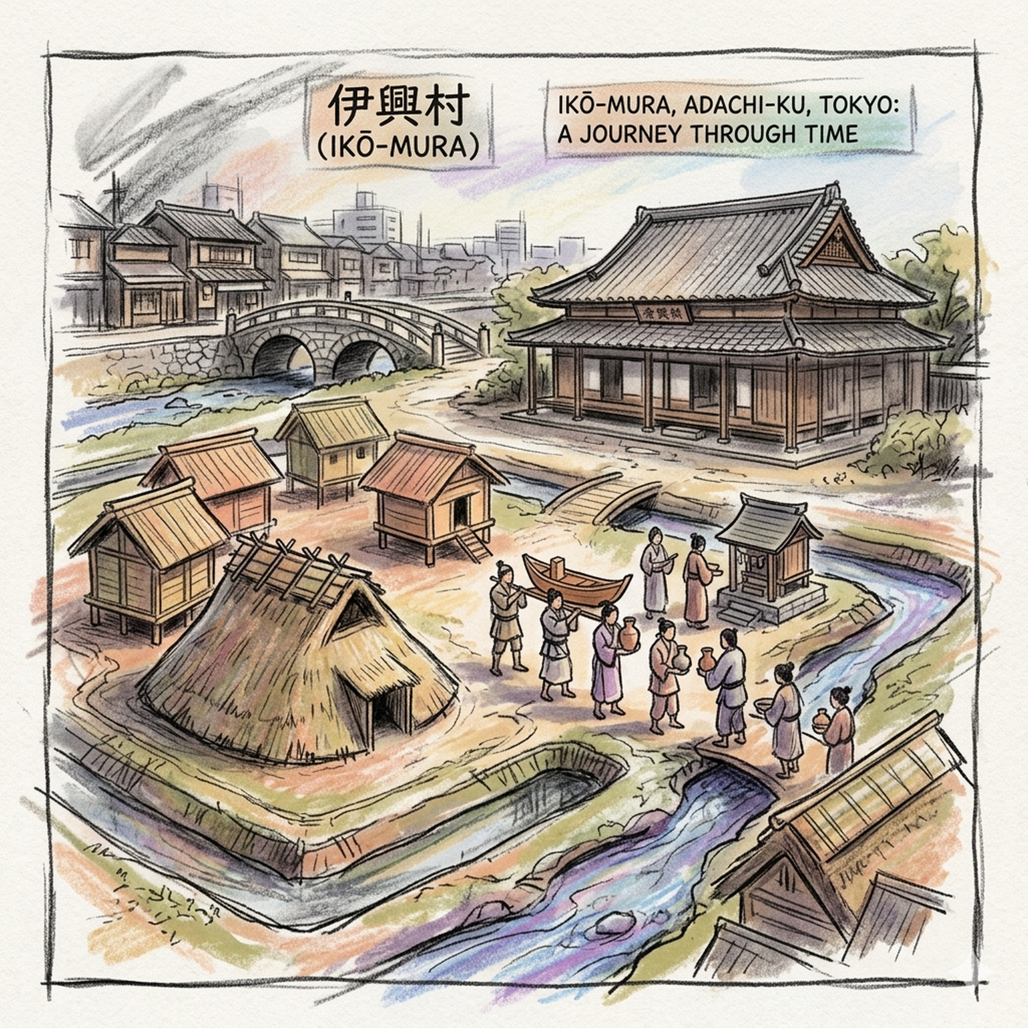
Modern Adachi Ward often presents as a quiet tapestry of residential blocks, yet the district of Iko serves as a profound historical threshold. Positioned as the "gateway" between the ancient capital and the rugged northern provinces of Oshu, Iko is not merely a modern suburb but a geological and historical palimpsest. To the trained eye, the area reveals itself as a site of ritual sacrifice, medieval military power, and sacred migration—all of which still vibrate beneath the modern asphalt. It is an environment shaped by its "natural levees," rare stretches of stable ground that provided a foothold for civilization amidst the shifting silts and reeds of the Kanto lowlands. To understand the modern layout of Iko, however, one must first look to the water that once dictated its very existence.
Listen to the historical stories told in detail (For subscribers only)
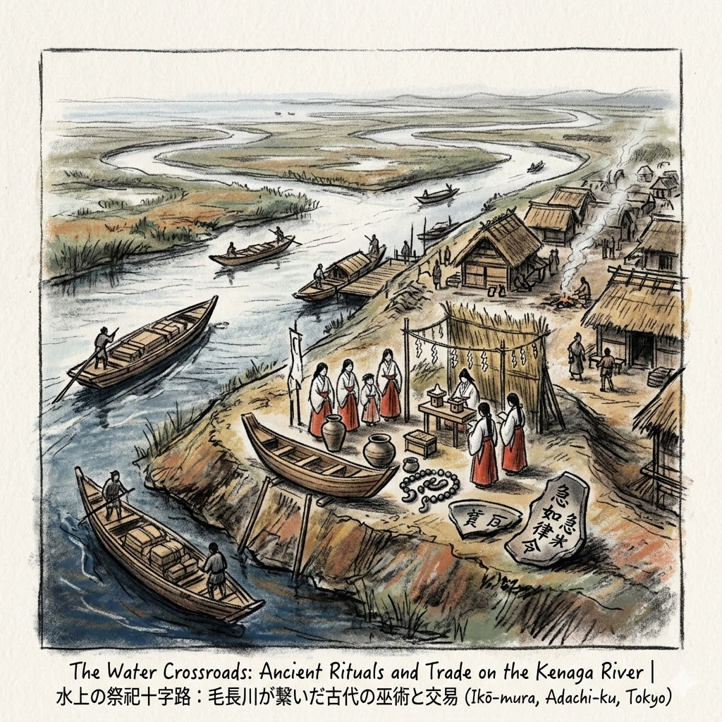
The Water Crossroads: Ancient Rituals and Trade on the Kenaga River
During the Kofun Period, nearly two millennia ago, the geography of the Kanto plain was defined by the Kenaga River. Far from being a stagnant marsh, this "water highway" was a vital artery connecting the inland plains to the sea. Iko, formed by these alluvial deposits, became a strategic "water crossroads." It was here that the Yamato Sovereignty projected its spiritual and bureaucratic authority, transforming a riverside settlement into a sophisticated hub of trade and ritual.
Archaeological excavations at the Iko Ruins have unearthed artifacts that refute the outdated notion of these lowlands as a "cultural wasteland." Most striking is the discovery of Bokusho-doki (ink-inscribed pottery) bearing the Taoist command “Kyū-kyū-nyo-ritsu-ryō” (急急如律令)—an incantation demanding spirits obey "as swiftly as the laws." This indicates an early penetration of bureaucratic and religious systems far more advanced than previously suspected for this region.
Artifacts of Power
Artifact Name | Type | Historical & Functional Description |
Boat-shaped wood (舟形木製品) | Ritual Tool | Miniature wooden vessels used in water-side ceremonies to pray for safe navigation. |
Magatama (子持勾玉) | Ritual Tool | Complex, comma-shaped beads symbolizing fertility and a direct link to Yamato authority. |
Sueki pottery (須惠器) | Trade/Ritual | High-quality stoneware, including complete wine vessels from the Kinki region, signaling elite trade. |
Inscribed Pottery (墨書土器) | Administrative | Ceramics bearing Taoist-influenced text, signaling early bureaucratic and religious penetration. |
These items suggest a vivid historical picture where local leaders used central-government-sanctioned rituals to solidify their power at the water’s edge.
"In the Iko Ruins... a vivid historical picture is suggested: at the edge of the Kenaga River, grand ceremonies were held periodically by ritual groups centered around 'maidens' (miko)."
As the Kenaga River shifted its course and silted toward the end of the Heian period, the town’s heart began to migrate, following the dry ground from the water to the emerging road networks.
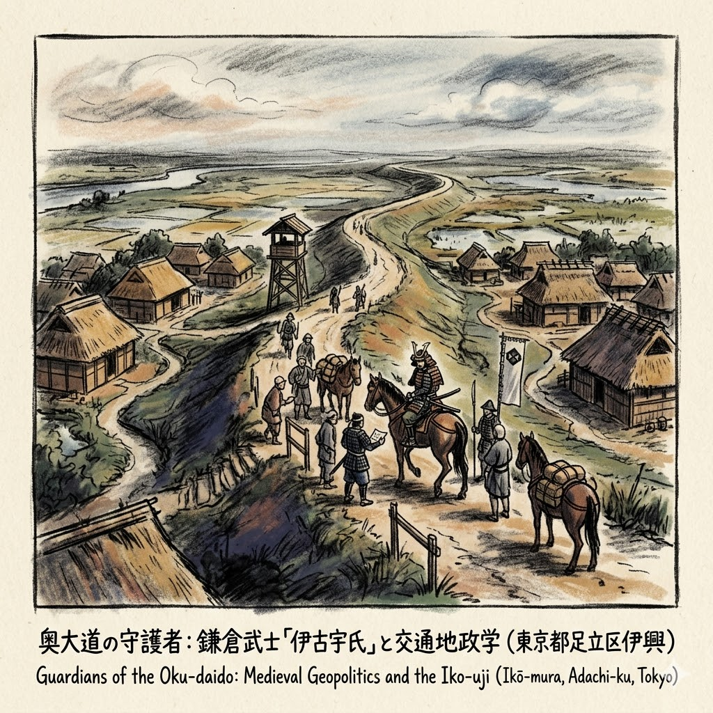
Guardians of the Oku-daido: Medieval Geopolitics and the Iko-uji
By the Kamakura Period (1185–1333), Iko’s strategic value transitioned from water trade to land-based military control. The "Oku-daido"—the great northern road and precursor to the Nikko Kaido—became the vital lifeline between the Shogunate in Kamakura and the northern provinces.
Control of this route fell to the Iko-uji, a powerful warrior clan that derived its name from the geography itself. The Azuma Kagami, the official record of the Shogunate, notes that in 1256, the warrior Iko Matajiro was commanded to oversee the security of this vital artery. This "blood-to-land" connection established a lasting communal identity; the clan was not merely ruling the land but was an extension of it, ensuring the Shogunate’s northern lifeline remained open through flood or civil strife. This role as "guardians of the road" created a regional status that would persist long after the samurai era.
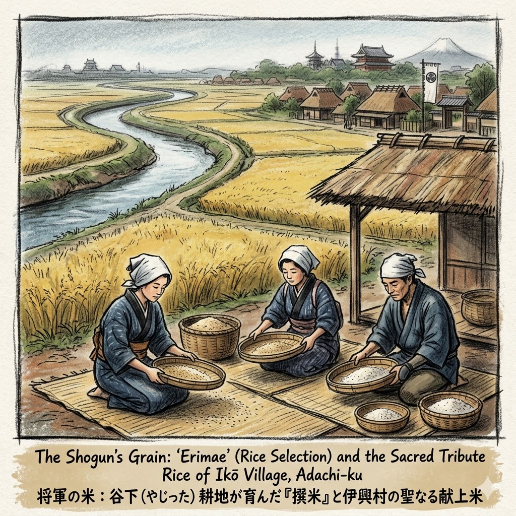
The Shogun’s Grain: "Erimae" and the Sacred Rice of Kaneiji
In the Edo period, Iko underwent a strategic shift when it became teraryo (temple land) for the Kaneiji Temple in Ueno, the spiritual heart of the Tokugawa Shogunate. The fertile, organic-rich alluvial soil of the "Yashita" fields, located between the old riverbed and the levees, was designated for the production of Kenshomai (tribute rice).
This was "brand management" of the highest order. The residents practiced "Erimae" (rice selection), an exhaustive process of precision where the rhythmic sound of bamboo sieves filled the village as every grain was screened to ensure uniform color and quality. By 1872, Iko’s rice was ranked number one in all of Tokyo Prefecture. Being a "temple village" granted residents unique political protection; when disputes arose, they could appeal to the authority of Kaneiji, effectively shielding them from common local grievances and solidifying their status as the Shogun's providers.
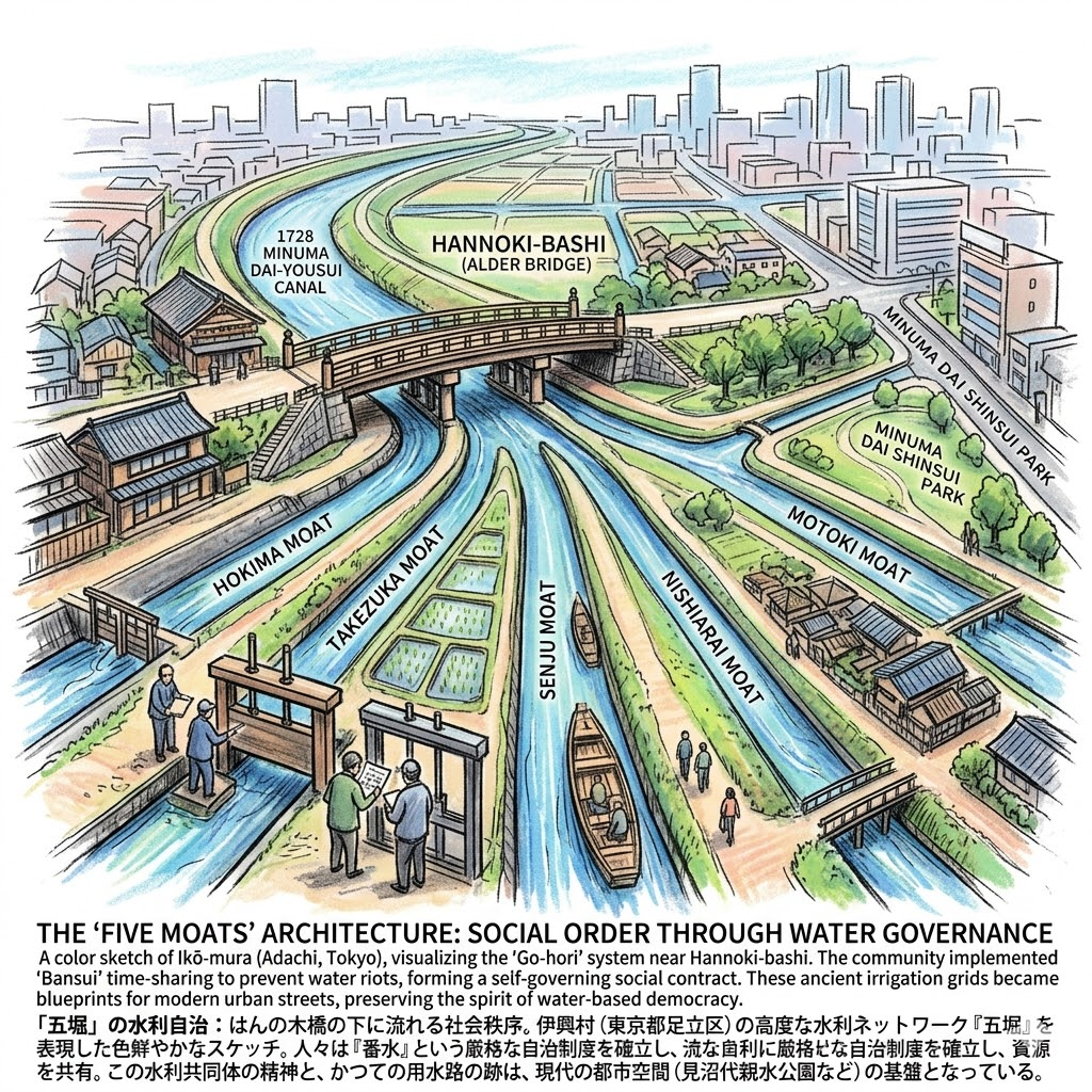
The "Five Moats" Architecture: Social Order through Water Governance
The agricultural prosperity of Iko reached its peak following the 1728 Minuma Dai-yousui canal project, a masterpiece of civil engineering. Near the Hannoki-bashi (Alder Bridge), the water was diverted into a sophisticated system known as the "Go-hori" (Five Moats). The bridge itself acted as the literal "parliament" of the water-sharing community—the physical valve through which the social contract was managed.
- Hokima Moat: Managed gates to ensure downstream flow.
- Takezuka Moat: Irrigated Iko’s core rice-producing zones.
- Senju Moat: A long-distance transport artery and irrigation source.
- Nishiarai Moat: Supported dense agricultural settlements.
- Motoki Moat: Managed the tail-end of the water supply.
To prevent "water riots," the community implemented "Bansui"—a time-share system where representatives monitored the sluice gates on a strict rotation. This "water-based democracy" functioned as a self-governing social contract, creating a system of regional cooperation that maintained order without direct government intervention. These ancient irrigation grids eventually became the blueprints for the modern urban streets of Adachi.
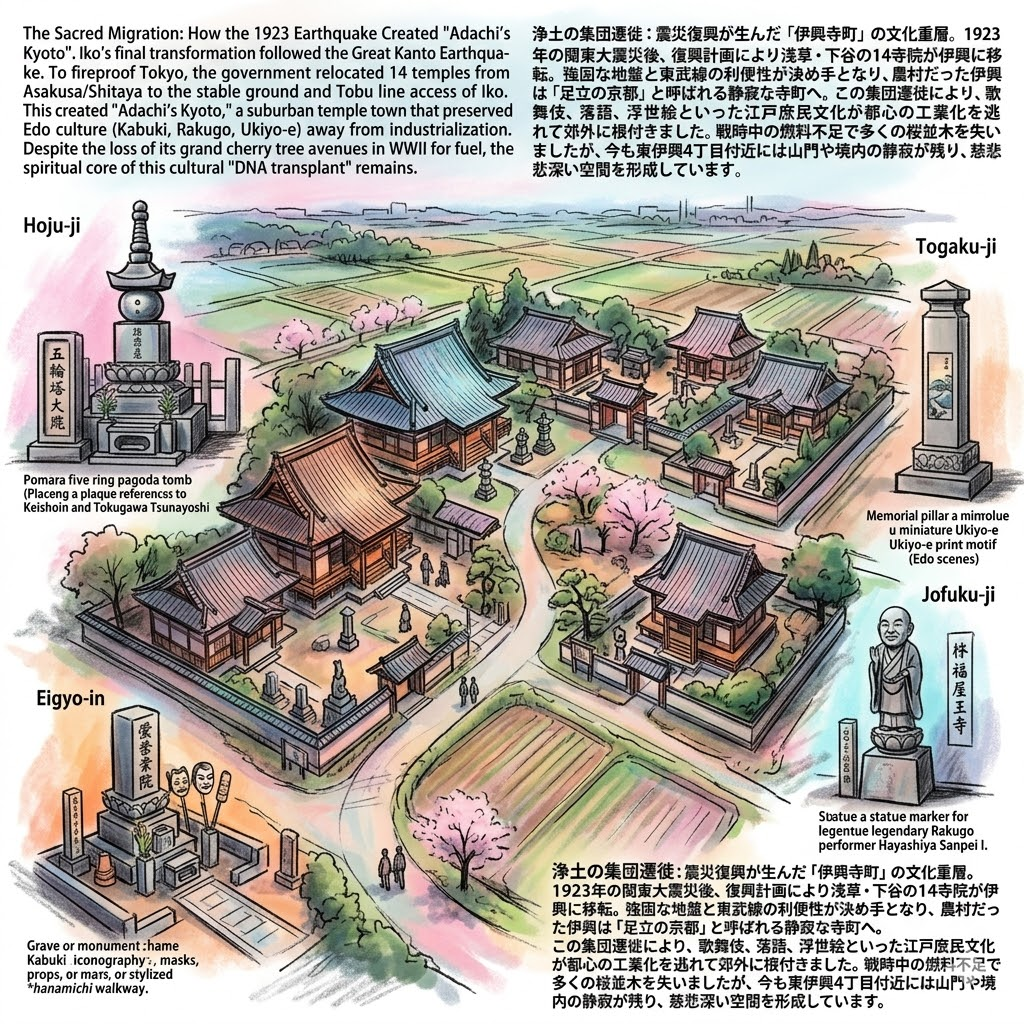
The Sacred Migration: How the 1923 Earthquake Created "Adachi’s Kyoto"
The final transformation of Iko occurred following the catastrophic 1923 Great Kanto Earthquake. To decentralize the city and improve fire safety, the government relocated dense temple clusters from Asakusa and Shitaya to the outskirts. Iko, with its stable ground and convenient access via the Tobu line, became a site for the "suburbanization of the sacred."
Fourteen temples migrated here, effectively transplanting the cultural DNA of Edo:
- Hoju-ji: Home to the tomb of Keishoin, the powerful mother of Shogun Tokugawa Tsunayoshi.
- Togaku-ji: Features the memorial and history of the Ukiyo-e master Utagawa Hiroshige.
- Eigyo-in: Known as the "Sukeroku Temple," housing the grave of the Kabuki hero Hanagawado Sukeroku.
- Jofuku-ji: The resting place of the legendary Rakugo performer Hayashiya Sanpei I.
This migration preserved Edo commoner culture—Kabuki, Rakugo, and Ukiyo-e—within a rural setting, shielding it from the industrialization of central Tokyo. Though the grand cherry tree avenues that once defined these temple approaches were lost to fuel shortages during World War II, the spiritual core of this "Adachi Kyoto" remains.
Walking the Layers: A Traveler’s Synthesis
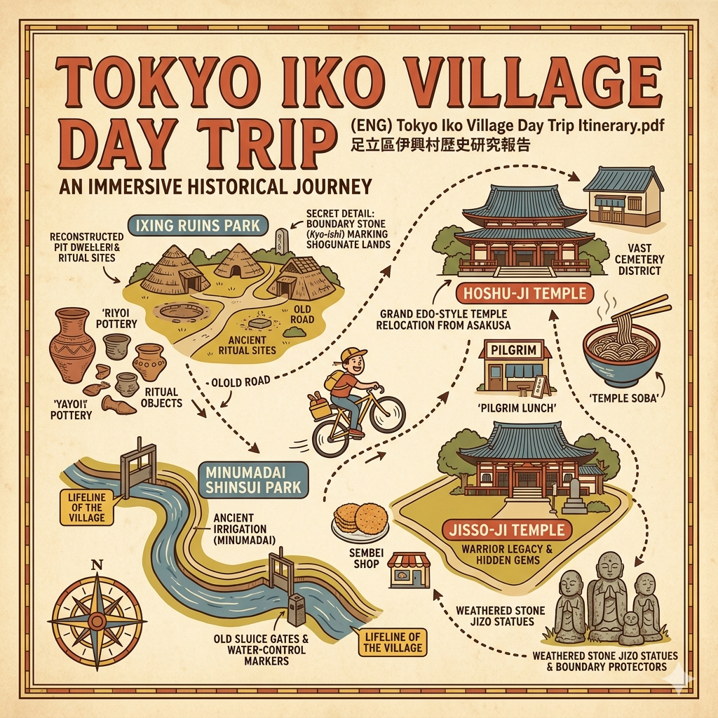
To walk Iko today is to move through a "Tera-machi" (Temple Town) where the silence of the temples contrasts with the vibrant history beneath your feet. Begin at the Iko Ruins Park to see the reconstructed pit dwellings and trace the path of the ancient Kenaga River. Nearby, the Shirahatatsuka Kofun (White Flag Mound), a 6th-century burial mound, remains a physical waypoint of the ancient elite. Conclude your journey at the Iko Hikawa Shrine, the oldest shrine in Adachi and the former heart of the Iko-uji clan’s power.
The Hoju-ji five-ringed pagoda (gorinto) stands as a hidden monument to Tokugawa power. This massive stone structure, dedicated to the mother of the fifth Shogun, is a rare physical reminder of the district's direct connection to the heights of Shogunal authority, tucked away in a quiet residential corner where its permanence defies the ephemeral nature of the surrounding city.
Reflecting on Iko, one realizes that cities are not built merely of concrete, but of "spatial folds." In a single square kilometer, the ancient water-side rituals of the Yamato, the medieval defense of the Oku-daido, and the sacred migration of the Edo elite coexist. The area proves that geography is destiny: the same natural levee that protected a Kofun-period village later supported a warrior’s road and an Edo-era temple town.
Even as we mourn the loss of the cherry tree avenues, Iko’s resilience suggests that culture, when rooted in the very soil and water of a place, can survive almost any catastrophe. The "water-based democracy" of the five moats may have evolved into an urban grid, but the spirit of communal cooperation remains.
When we walk these streets, we are not just moving through space; we are moving through a 2,000-year-old dialogue between humanity and the environment. We must ask ourselves: "When we walk a street, whose footprints are we truly following?" In Iko, the answer involves a maiden, a warrior, a farmer, and a monk—all bound by the same stretch of stable ground.
For more deep-dive historical guides into the invisible layers of our cities, subscribe to Historical Travel Stories.
Logistics & Utility
How to Get There
- Train: Take the Tobu Skytree Line to Takenotsuka Station. From the West Exit, Iko is a 15-20 minute walk.
- Bus: Local buses run frequently from Takenotsuka Station toward the Iko Ruins and the temple district.
Recommended Tours
- Self-Guided Tera-machi Walk: Start at the Iko Ruins Park, head south through the cluster of 14 temples in the Higashi-Iko 4-chome area (noting the Hiroshige memorial at Togaku-ji), and finish at the Iko Hikawa Shrine.
Accommodations
- Nearby Stay: For a broader historical experience, stay in nearby Senju. As a former post-town on the Nikko Kaido, it offers a wider range of accommodations while maintaining a direct connection to the historical "Oku-daido" route that leads straight to Iko.
Q & A
How did water shape Iko's history from ancient rituals to irrigation?
Water has been the fundamental architect of Iko’s history, evolving from a sacred "watery crossroads" for ancient rituals into a highly engineered irrigation network that powered one of Edo's most productive agricultural regions.
The Sacred Highway: Ancient Rituals and TradeDuring the Kofun Period, the Kenaga River was much wider and more powerful than it is today, serving as a vital "water highway" connecting the Kanto inland to the sea. This geography shaped Iko into a strategic "border gateway" where water served two primary functions:
- Ritualistic Protection: Rituals led by miko (priestesses) were held at the water's edge to ensure safe passage. Archaeologists found boat-shaped wooden objects (舟形木製品)—miniature ships designed to be fixed into the riverbank—which acted as spiritual offerings for safe navigation along these treacherous trade routes.
- Symbolic Power: The discovery of the Kochi Magatama (a complex comma-shaped bead) suggests that rituals also celebrated fertility and signaled the local leader's connection to the central Yamato Sovereignty, who controlled these valuable water-based trade networks.
The Engineered Lifeline: Edo Period IrrigationAs the natural flow of the Tone River changed and the Kenaga River silted up, Iko's relationship with water shifted from navigation to intensive agriculture. By the Edo Period, water was no longer just a path, but a strictly managed resource:
- Minuma Dai-yousui Canal: In 1728, the massive Minuma Dai-yousui canal was constructed to transform barren low-lying wetlands into productive rice paddies. Iko became a critical technical node in this system at the Hannoki-bashi (Red Alder Bridge), where the water was split.
- The "Five Moats" (Go-hori): At this junction, the water was divided into five main branches—the Go-hori—which irrigated specific sectors like Takezuka and Senju. This artificial network turned unstable floodplains into a "grid-like machine" for rice production.
Water as a Source of Social OrderThe scarcity of water during the Edo Period forced the development of a sophisticated social hierarchy and governance system known as Bansui (番水).
- Because water was limited, villages had to follow a strict time-based rotation system.
- Iko became a central meeting point for water representatives from different villages to coordinate and prevent "water riots".
- This transition from "natural river rituals" to "contractual water management" represents the final stage of Iko’s spatial transformation, where the community's survival shifted from divine favor to collaborative engineering and technical governance.
Would you like me to create a tailored report that provides a more detailed timeline of Iko's transition from a ritualistic center to a major agricultural hub, or perhaps an infographic mapping the "Five Moats" irrigation system? A video overview exploring these historical layers is also an option. Let me know if you are interested!
What are the Five Moats and their specific coverage?
The Five Moats (Go-hori) were five major branch canals created following the construction of the Minuma Dai-yousui canal in 1728. This water system was designed to transform the low-lying wetlands of the Adachi area into productive rice paddies.
The water flow was split into these five branches at a strategic junction near the Hannoki-bashi (Red Alder Bridge) in Iko. According to the sources, the specific coverage and management responsibilities for each moat were as follows:
Moat Name (Go-hori) | Primary Coverage Area (Present-day) | Water Management Responsibilities |
|---|---|---|
Hokima-hori | Hokima area, Adachi Ward | Maintaining water gates and ensuring sufficient flow to downstream areas. |
Takezuka-hori | Takenotsuka and Iko areas, Adachi Ward | Providing direct irrigation for the core rice-growing regions of Iko. |
Senju-hori | Central Adachi Ward and Senju area | Managing long-distance water transport and coordinating interests between various villages. |
Nishiarai-hori | Nishiarai area, Adachi Ward | Supporting the dense agricultural settlements in the local area. |
Motoki-hori | Motoki area, Adachi Ward | Managing the end-of-stream water supply, which frequently faced challenges with water shortages. |
Historical Significance of the Five MoatsThe creation of this network necessitated a high level of social cooperation and technical governance. Because water volume was limited, especially for those at the "end-of-stream" like the Motoki-hori, a strict rotation system known as Bansui was implemented. This required village representatives to meet in Iko to coordinate schedules and guard water gates to prevent "water riots".
Today, while much of the agricultural land has become residential, the legacy of the Five Moats remains visible in the Minuma Dai Shinsui Park, which follows the path of the original water artery. Historical records detailing the specific water distribution ratios for the Five Moats are still preserved near the Iko Ruins Park.
Reference and Further reading
- 足立区のあけぼの―住み始めた人々と伊興遺跡, accessed May 1, 2026,
- 第2回 遺跡を歩く ~伊興遺跡公園展示館・白旗塚史跡公園~ (現地学習), accessed May 1, 2026,
- 竹ノ塚の古墳と古の祭祀「伊興遺跡公園」を歩く - 帝都を歩く, accessed May 1, 2026,
- 残されたメッセージ―古代伊興の官人と文字―|足立区, accessed May 1, 2026,
- 舟形木製品 - 足立区, accessed May 1, 2026,
- 伊興遺跡と舎人遺跡|足立区, accessed May 1, 2026,
- 伊興小学校で大規模な遺跡発掘 古墳時代~江戸時代の人々の痕跡現る - 足立朝日, accessed May 1, 2026,
- 伊興遺跡 - 全国文化財総覧, accessed May 1, 2026,
- IROHA- 足立区, accessed May 1, 2026,
- 渕の宮(伊興氷川神社) - ニッポン旅マガジン, accessed May 1, 2026,
- 伊興遺跡公園 | あだち観光ネット, accessed May 1, 2026,
- 伊興七福神めぐり&歴史探訪まち歩き, accessed May 1, 2026,
- 伊興七福神 - 越谷市郷土研究会, accessed May 1, 2026,
- 巽跡めぐむ資料 - 越谷市郷土研究会, accessed May 1, 2026,
- 伊興遺跡公園展示館 - 足立区, accessed May 1, 2026,
- 歩こうあだち〈舎人から竹の塚編〉~地域の歴史を物語る宝庫・水路が今に生きている街~ - 伊興は歴史の宝庫 - 足立区観光交流協会, accessed May 1, 2026,
- 伊興寺町 | ニッポン旅マガジン, accessed May 1, 2026,
- 足立区最古の伊興氷川神社、境内に残された富士山の溶岩【プロハイカー斉藤正史のTOKYO山頂ガイド File.99】 - BE-PAL, accessed May 1, 2026,
- 東京都市計画地区計画の変更(足立区決定) 都市計画伊興町前沼地区地区計画を次のように, accessed May 1, 2026,
- 伊興寺町散策路 | あだち観光ネット, accessed May 1, 2026,