(ENG) Komatsugawa Riverside Walk: Tracing WWII Scars and Rebirth in Tokyo
A deep dive into Tokyo’s hidden history at Komatsugawa. This guide takes you along the Arakawa River to witness the scars of the Great Tokyo Air Raid and the quiet beauty of its modern-day rebirth. Perfect for travelers seeking a poignant, off-the-beaten-path historical walk.

This is a historical travel story and walking guide to Komatsugawa, a riverside district in eastern Tokyo. By exploring the remnants of the old Komatsugawa Lock and the Arakawa riverbank, it uncovers the tragic memory of the 1945 Great Tokyo Air Raid and shows how this industrial area transformed into a peaceful park, offering a unique perspective on the city's resilience.
To the casual observer, the district of Komatsugawa appears as a serene expanse of high-rise apartments and riverside parks on the eastern edge of Tokyo. Yet, for the cultural historian, this patch of land—hemmed in by the Arakawa and Shinkawa rivers—functions as a profound "spatial archive." As the historic eastern gateway to the city, Komatsugawa offers a compressed narrative of Tokyo’s evolution. It is a place where the modern metropolis was built not through organic expansion, but through a recurring cycle of transformation and sacrifice.
In Komatsugawa, history is not merely a collection of stories; it is physically embedded in the very levees and soil of the neighborhood. To understand this landscape is to understand the "politics of the fringe"—the way a city chooses what to preserve and what to bury beneath the earth in the name of progress. This journey through the layers of the levee begins not with engineering or tragedy, but with a humble green vegetable and the stroll of a Shogun.
Listen to the historical stories told in detail (For subscribers only)
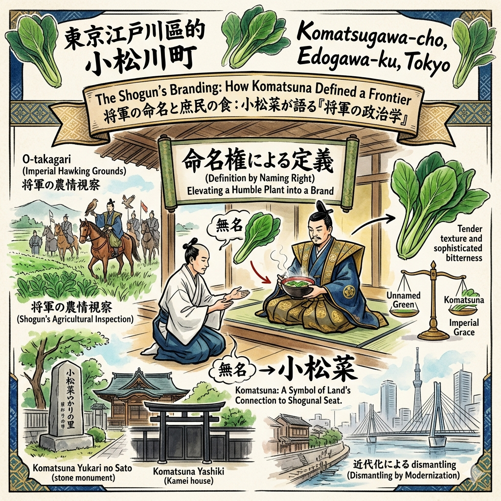
The Shogun’s Branding: How Komatsuna Defined a Frontier
In the Edo period, the "urban fringe" served as more than just a geographic boundary; it was a vital source of sustenance and a stage for the display of Shogunal authority. This area was designated as O-takagari (Imperial Hawking Grounds), where the Shogun’s frequent excursions were as much about inspecting the agricultural health of the land as they were about recreation. It was through this royal patronage that "urban fringe agriculture" was transformed into a lasting cultural brand.
While local folklore and the Shinpen Musashi Fudoki Ko predominantly credit the eighth Shogun, Tokugawa Yoshimune, with the naming of the district's famous vegetable in 1719, some historians argue the naming occurred earlier under the fifth Shogun, Tsunayoshi. Regardless of the academic debate, the popular narrative remains a masterclass in "naming politics." During a rest at the Katori Shrine, the Shogun was served a simple sumashijiru (clear soup) by the priest Kamei Izumi-no-kami Naganori. The soup featured a vibrant, unnamed local green. Impressed by the vegetable’s tender texture and its refreshing, sophisticated bitterness, the Shogun decreed it should bear the name of the land: Komatsuna.
This act converted a "무명(unnamed)" natural resource into an act of imperial grace. By bestowing a name, the Shogun defined the identity of the frontier through his own authority, elevating a humble plant into a symbol of the land’s connection to the Shogunal seat.
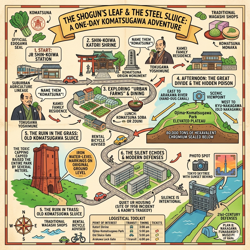
Katori Shrine and the Komatsuna Origin Monument The Katori Shrine (specifically the Shin-Koiwa Katori Shrine) remains a vital physical site for this history. Visitors can find the "Komatsuna Yukari no Sato" stone monument and an altar dedicated to the vegetable’s guardian deity. It serves as a rare surviving link to the Edo-era agricultural civilization that once defined this riverfront.
While the Shogun’s visit brought prestige to the land, the 20th century would bring a radical physical dismantling of the village itself.
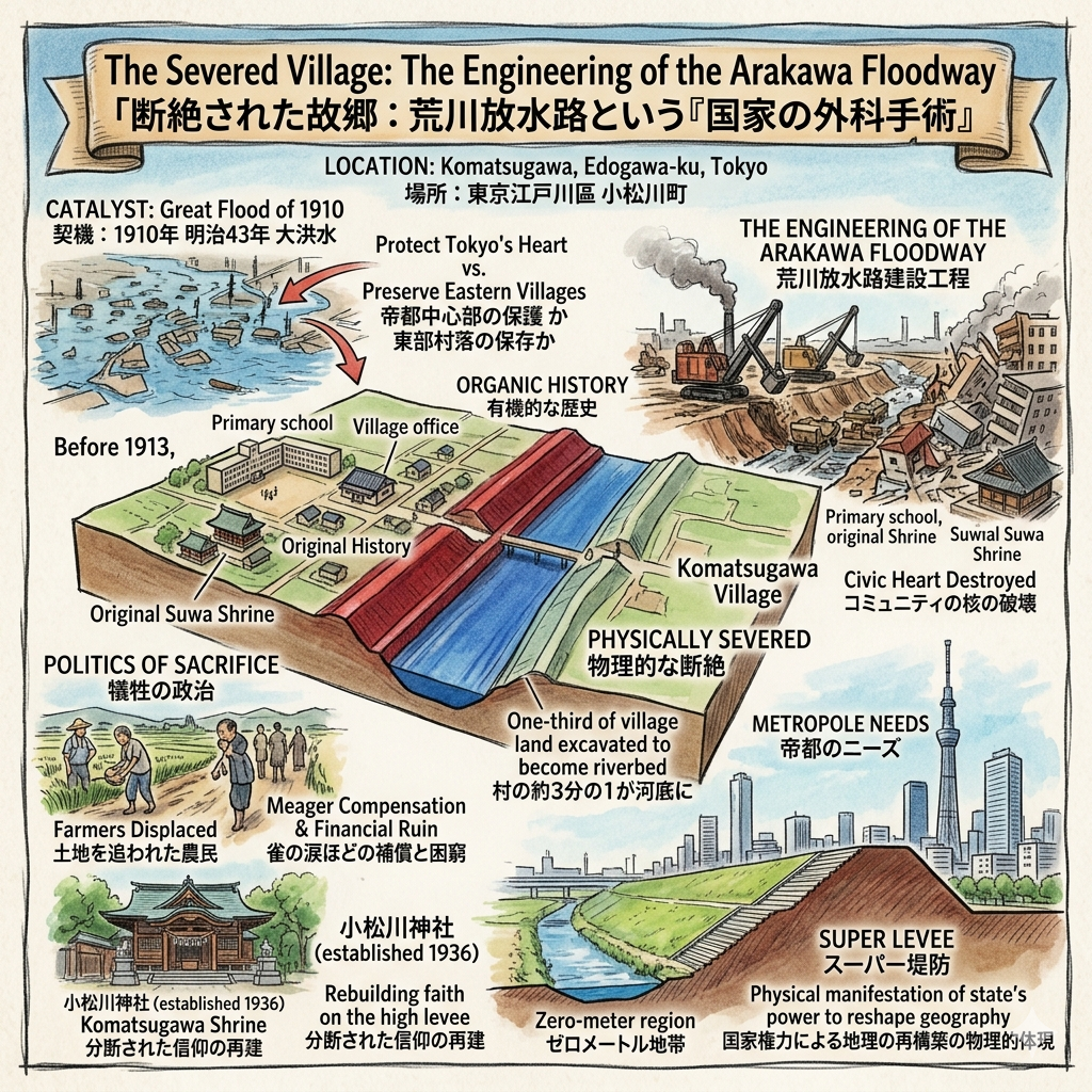
The Severed Village: The Engineering of the Arakawa Floodway
By the late Meiji era, the relationship between the city and its rivers shifted from one of harmony to one of defense. Following the catastrophic Great Flood of 1910, the Japanese government faced a stark choice: protect the economic and imperial heart of Tokyo—districts like Ginza and Nihonbashi—or preserve the organic history of the eastern villages. The state chose the former, initiating the construction of the 22-kilometer Arakawa Floodway in 1913.
The scale of the project was gargantuan, but the physical cost was born entirely by the residents of Komatsugawa. The floodway did not simply bypass the village; it cut through its civic heart. One-third of the village's land was physically excavated to become the riverbed. This "modern state" engineering required the destruction of the primary school and the village office, effectively erasing the community's administrative and social centers.
"The village was not just moved; it was administratively and physically severed. Farmers who received meager compensation for their ancestral lands often fell victim to financial ruin or fraud, losing their livelihoods to the progress of the imperial capital."
This was the "politics of sacrifice." By designating Komatsugawa as a "flood relief zone," the government ended the village’s organic history. Today, this dominance is visible in the "Super Levee"—a massive, staircase-like urban landscape that rises high above the "Zero-meter region." It is a physical manifestation of the state's power to reshape geography to suit the needs of the metropole.
The Iron Castle in the Grass: The Rise and Fall of the Komatsugawa Locks
As Tokyo transitioned into an industrial powerhouse, water remained its primary artery. Before the age of the highway, the canals of the Koto Delta carried the city's lifeblood—salt, rice, and stone. However, the creation of the Arakawa Floodway introduced a technical hurdle: a 3.1-meter water level difference between the new floodway and the old river networks.
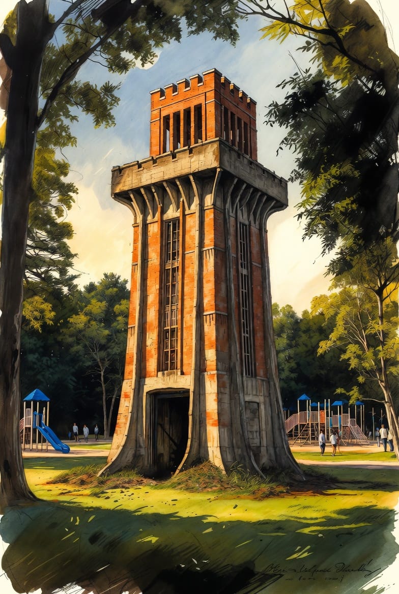
To bridge this gap, the Komatsugawa Lock Gate was completed in 1930. A massive reinforced concrete structure influenced by Art Deco and functionalism, it stood like an "Iron Castle" over the water. At its peak in the 1950s, it was a thriving logistics hub, with hundreds of barges queuing daily. Its continued relevance to national identity was underscored as recently as 2023, when Emperor Naruhito visited the site to inspect both this historic gate and the modern Arakawa Lock Gate, bridging the imperial past with contemporary disaster prevention.
Today, the Old Komatsugawa Lock Gate "Red Brick Tower" sits in the Wind Plaza of Ojima Komatsugawa Park. Half-buried in the earth to stabilize it against land subsidence, the tower acts as a displaced sentinel—a navigational ghost in the middle of a modern playground.
Yet, the beauty of the park’s greenery hides a much darker industrial legacy just beneath the soil.
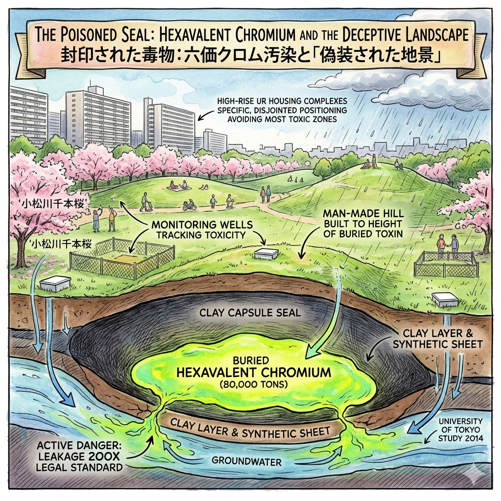
The Poisoned Seal: Hexavalent Chromium and the Deceptive Landscape
In the rush for high-growth industrial output during the post-war years, environmental justice was traded for production. Komatsugawa became the site of a Nippon Chemical Industrial plant, which for decades treated industrial waste with negligence. In 1975, it was revealed that 80,000 tons of hexavalent chromium—a highly carcinogenic toxin—had been buried under the land intended for a public park.
The solution was a "historical compromise": the state sealed the poison in a "clay capsule" rather than removing it. However, the "spatial archive" here is one of active danger. A 2014 University of Tokyo study revealed that the "seal" is imperfect; during heavy rain or snow, hexavalent chromium still leaks into the surrounding environment at 200 times the legal standard limit. The topography of the park is a literal map of this contamination: the man-made hills are not aesthetic choices, but mounds built to the height of the poison.
Invisible Markers of the Poisoned Seal:
- Monitoring Wells: Discreet white metal covers and fenced-off monitoring stations continue to track the subterranean toxicity of the "clay capsule."
- UR Housing Layout: The specific, often disjointed positioning of the high-rise housing complexes was dictated by the contamination map, ensuring foundations avoided the most toxic buried caches.
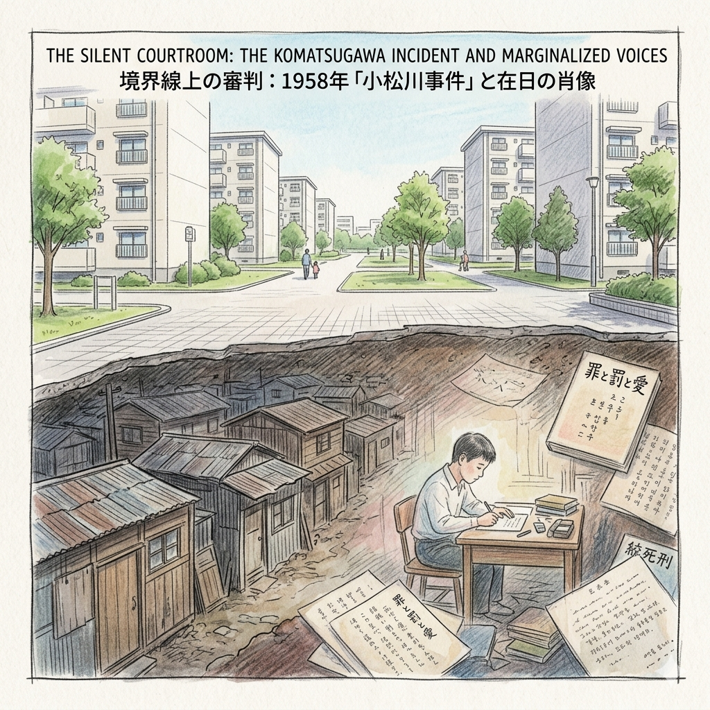
The Silent Courtroom: The Komatsugawa Incident and Marginalized Voices
Beneath the physical layers of soil lies a layer of social trauma. In the 1950s, Komatsugawa was home to marginalized "slums" occupied by the Zainichi Korean community—people stripped of nationality and facing systemic discrimination. This atmosphere of social despair produced the 1958 "Komatsugawa Incident."
The case involved Lee Jin-woo, a young student whose trial for murder sparked an intellectual firestorm. Through his letters in Crime, Punishment, and Love, Lee forced the public to confront the "invisibility" of the Korean community and the absurdity of a state death penalty imposed on a person the state refused to acknowledge as a citizen. The case later inspired Nagisa Oshima’s film Death by Hanging, which remains a seminal critique of state power.
Today, there is an "intentional silence" regarding this history. There are no monuments to the slums or the trial. The modern redevelopment of Komatsugawa into a pristine park-side district effectively erased the "cramped, hostile" spaces that produced such despair. In the clean lines of the new architecture, the voices of the marginalized have been systematically quieted.
Philosophical Conclusion: The Layers of Living History
Komatsugawa serves as a microcosm for the modern city, a landscape defined by "The Shogun's Light," "The Engineer's Cut," "The Industrial Steel," "The Hidden Poison," and "The Marginalized Voice." It is a place where history is not just remembered but layered, sealed, and occasionally leaked.
When we walk through the pristine cherry blossoms of Komatsugawa today, we must ask: Are we standing on a place of rebirth, or a place of profound, layered burial? Does the "Super Levee" protect us from the river, or does it merely hide the leaking ground beneath our feet? The beauty of the riverfront is a testament to the city’s capacity to overwrite its most painful chapters, but the archive beneath remains restless.
Enjoyed this exploration? Subscribe to Historical Travel Stories for more deep dives into the forgotten boundaries and hidden narratives of the world’s great cities.
Traveler’s Appendix
Hidden Gems
- Komatsuna Vending Machines: Found throughout the district, these machines offer fresh-harvested greens and Komatsuna-flavored snacks, a modern nod to the Shogun's branding legacy.
- Kamei Family House (Komatsuna Yashiki): Located near the Katori Shrine, this ancestral home features magnificent black-lacquered gates. It is the residence of the descendants of the priest who hosted Shogun Yoshimune and remains the most authentic link to the Edo-era vibe of the district.
Logistics
- How to get there: Take the Toei Shinjuku Line to Higashi-Ojima Station. The station itself spans the Kyu-Nakagawa River, serving as a perfect starting point for exploring the "watery boundary."
- Recommended Walking Route: Begin at the Old Komatsugawa Lock Gate (Wind Plaza) to view the Art Deco ruins, walk south along the Super Levee to observe the "staircase" geography of the zero-meter zone, and conclude at the Katori Shrine and Kamei Family House to find the origins of the vegetable that gave the village its name.
Q & A
How did water management projects shape Komatsugawa's geography and society?
Water management projects have been the primary force in shaping Komatsugawa’s identity, transforming it from a prosperous agricultural suburb into a fragmented "sacrifice zone" engineered for the safety of central Tokyo. These projects fundamentally altered both the physical landscape and the social fabric of the community through several historical stages:
1. From Fertile Plains to Artificial RiversIn the Edo period, Komatsugawa thrived as a "watery frontier" where the Nakagawa’s fertile alluvial soil supported a specialized agricultural economy. This era’s geography was defined by its productivity, famously producing "Komatsuna," a vegetable named by Shogun Tokugawa Yoshimune during a falconry trip. However, the geography was radically rewritten following the 1910 Great Flood. To protect Tokyo's core, the government constructed the Arakawa Floodway (1913–1930), a massive 22-kilometer artificial river that swallowed one-third of Komatsugawa Village, turning fertile farmland and residential streets into a 500-meter-wide riverbed.
2. Community Dissolution and Social FragmentationThe social impact of the Arakawa Floodway was catastrophic for the local population:
- Administrative Death: In 1914, the physical isolation caused by the new river led to the formal dissolution of the original village. The community was split, with the west bank becoming Komatsugawa Town and the east bank merging into Matsue Village, leaving a permanent fracture in local identity.
- Displacement of Core Institutions: Key social anchors, including the village office, primary school, and the centuries-old Suwa Shrine, were forcibly relocated.
- Economic Ruin: Many farmers received meager compensation and, unfamiliar with monetary investment, fell victim to fraud or bank failures, losing their generational wealth along with their land.
3. Technological Management of the "Zero-Meter" ZoneAs the geography transitioned into a high-risk flood control area, Komatsugawa became a site for advanced water engineering:
- Komatsugawa Lock Gate: Completed in 1930, this massive Art Deco structure was built to manage a 3.1-meter water level difference between the Arakawa and Old Nakagawa. For decades, it served as a vital logistics hub, fostering a unique "lock gate economy" where boatmen traded while waiting for passage.
- Super Levees: Today, the landscape is defined by its status as a "zero-meter region." To mitigate the risk of catastrophic flooding, massive "Super Levees" (100-meter wide embankments) have been built, creating a distinct "staircase" urban profile that separates the river from residential zones.
4. Environmental Sealing and Modern LandscapesWater management also intersects with Komatsugawa's industrial history. Post-WWII industrialization left the land heavily contaminated with Hexavalent Chromium. The solution was a "historical compromise" in urban geography:
- Oshima Komatsugawa Park: This green space was built as a "poison capsule," where toxic waste was chemically neutralized and "sealed" beneath artificial hills (mori-tsuchi).
- Geography of Monitoring: The current landscape features white metal monitoring caps and fenced-off areas that serve as the "front line" of ongoing environmental surveillance, reminding residents that the ground beneath them remains a legacy of industrial sacrifice.
In summary, Komatsugawa's geography is not natural but is a "land archive" of state-driven interventions. Every park and levee reflects a history where local community needs were secondary to the broader goal of protecting the imperial capital from the very waters that once gave the region its life.
How does Komatsugawa balance its industrial past with modern environmental protection?
Komatsugawa balances its industrial past with modern environmental protection through a strategy known as a "historical compromise," where toxic industrial legacies are physically "sealed" beneath public leisure spaces and managed through long-term technical surveillance.The following points detail how this balance is maintained:
1. The "Poison Capsule" StrategyThe most significant industrial legacy is the hundreds of thousands of tons of hexavalent chromium slag left by chemical plants, such as Nippon Chemical Industrial, during Japan's rapid economic growth period. To balance this danger with the need for urban space:
- Physical Sealing: Authorities chemically treated the slag to neutralize it into trivalent chromium, then enclosed it within thick clay layers and synthetic liners.
- Geographic Transformation: This "poison capsule" was buried under several meters of clean soil, forming the high platforms (mori-tsuchi) that now characterize Oshima Komatsugawa Park. This allows a toxic site to function as a green space for recreation.
2. Urban Planning as a "Pollution Map"Modern development in Komatsugawa is carefully choreographed around its industrial scars:
- Strategic Housing Placement: The foundations of the high-rise public housing complexes (UR Danchi) surrounding the park were intentionally designed to avoid the most heavily contaminated core areas. The layout of these buildings serves as a physical "pollution map" of the subsurface.
- Infrastructure for Disaster Prevention: The area’s geography as a "zero-meter region" has led to the construction of Super Levees. These massive embankments serve a dual purpose: they protect against flooding from the Arakawa while also providing a stable, engineered layer over the reclaimed land.
3. Continuous Monitoring and SurveillanceThe balance is not static but requires ongoing management to ensure environmental protection remains effective:
- Detection Infrastructure: Throughout the park and sidewalks, white metal monitoring caps and fenced-off areas act as the "front line" for checking groundwater levels and potential chemical leakage.
- Managing Leakage: Despite the sealing, research (such as a 2014 study from the University of Tokyo) shows that rain or snowmelt can still cause hexavalent chromium to leak at levels far exceeding safety standards, highlighting that environmental protection in Komatsugawa is a perpetual task rather than a one-time fix.
4. Preservation of Industrial HeritageKomatsugawa preserves its industrial history not just as a hazard, but as a cultural asset within a protected environment:
- The Old Komatsugawa Lock Gate: Rather than being entirely demolished, a portion of this 1930s Art Deco structure (the "Red Brick Tower") was preserved within the park's "Wind Plaza." It stands as a surreal reminder of the area's history as a steel and oil-driven logistics hub.
- Modern Water Management: The newer Arakawa Rock Gate (2005) balances historical water transport roles with modern emergency functions, serving as a core route for transporting supplies and rescuing victims during disasters.
In summary, Komatsugawa's balance is achieved through technological encapsulation and selective memory. While the surface offers a beautiful landscape of cherry blossoms and parks, the underlying infrastructure remains a highly engineered system designed to monitor and contain the toxic remnants of its industrial era.
Reference and Further reading
- 小松川 (江戸川区) - accessed April 13, 2026,
- 江戸川区今昔物語「江戸川区ってこんなとこ!」 - YouTube, accessed April 13, 2026,
- 東京都江戸川区の江戸東京野菜「小松菜」1-小松菜発祥の地・小松菜の名前の由来・新小岩香取神社・小松菜屋敷・江戸川区の小松菜商品 - コウジ菌のブログ, accessed April 13, 2026,
- 小松菜の産土神 - 新小岩 間々井香取神社, accessed April 13, 2026,
- 江戸時代、時の将軍に名前をつけてもらった野菜は? - やさいde日本史クイズ|知る・楽しむ/ サラダカフェ Salad Cafe, accessed April 13, 2026,
- 小松菜の名付親は将軍様!?【鈴木杏樹のいってらっしゃい】 – ニッポン放送 NEWS ONLINE, accessed April 13, 2026,
- ごせき晩生小松菜(伝統小松菜) | 江戸東京野菜について | 東京の農業 - JA東京中央会, accessed April 13, 2026,
- 「小松菜」命名のお話 - 江戸川区, accessed April 13, 2026,
- コマツナ - accessed April 13, 2026,
- 小松菜(江戸野菜③ 江戸の食文化61) - 気ままに江戸 散歩・味・読書の記録, accessed April 13, 2026,
- 2.3.3.4 中川放水路(新中川)開削, accessed April 13, 2026,
- 明治・大正・昭和期に行われた荒川放水路開削工事と 市民の生活, accessed April 13, 2026,
- 9 新旧歴史を刻む小松川閘門 江戸川区ホームページ, accessed April 13, 2026,
- 中川船番所資料館【江東区】 旧中川と小名木川の歴史資料を見学 - 江戸川フォトライブラリー, accessed April 13, 2026,
- 第93回 小名木川物流ルートを見張る中川番所。 - 江戸散策 - クリナップ, accessed April 13, 2026,
- 春の桜・初夏の紫陽花 旧小松川閘門に昭和の残像, accessed April 13, 2026,
- 大島小松川公園 - 東京都東部7公園, accessed April 13, 2026,
- 【旧小松川閘門】東京都江戸川区で初の歴史的建造物として選定 東京都都市整備局, accessed April 13, 2026,
- 【天皇陛下】「旧小松川閘門」「荒川ロックゲート」を視察される 水に関する研究をライフワーク, accessed April 13, 2026,
- 天皇陛下は旧小松川 閘門 - ( - こうもん - ) - 、荒川ロックゲート - 宮内庁, accessed April 13, 2026,
- 旧小松川 閘門|お知らせ|With! 東京歴建PROJECT, accessed April 13, 2026,
- 無害化対策後も都立公園から6価クロムが流出するメカニズムを解明 | 東京大学, accessed April 13, 2026,
- 都立小松川大島公園へ行って思うこと, accessed April 13, 2026,
- 六価クロム鉱さいによる汚染土壌 江戸川区ホームページ, accessed April 13, 2026,
- 大島小松川公園 - accessed April 13, 2026,
- 六価クロム汚染、都の監視は適切になされていたか?~未だ完成をみない東京都市街地再開発事業 | いなみや須美, accessed April 13, 2026,
- 「あいまいな」存在としての「在日」像 : 大江健三郎の ... - Kobe University, accessed April 13, 2026,
- 原爆映画にみる「無垢なる被害者」像の構築・解体・再構築, accessed April 13, 2026