(ENG) Minami-ayase Historical Walk – Tracing the Vanished Borders and Resilient Memories of East Tokyo
Embark on a journey to find the "lost" Minami-ayase. Along the winding Ayase River and through the industrial layers of East Tokyo, discover how local life and faith have adapted to a century of dramatic geographical and administrative change.

This is a historical travel story and walking guide to Minami-ayase, a "vanished" administrative district in East Tokyo. By tracing the banks of the Ayase River and exploring local shrines, it uncovers how this former farming land was reshaped by industrialization, flood control, and railway expansion. Readers will gain a unique perspective on how local identity persists even after administrative borders disappear in the face of urban modernization.
The Strategic Anchor of East Tokyo
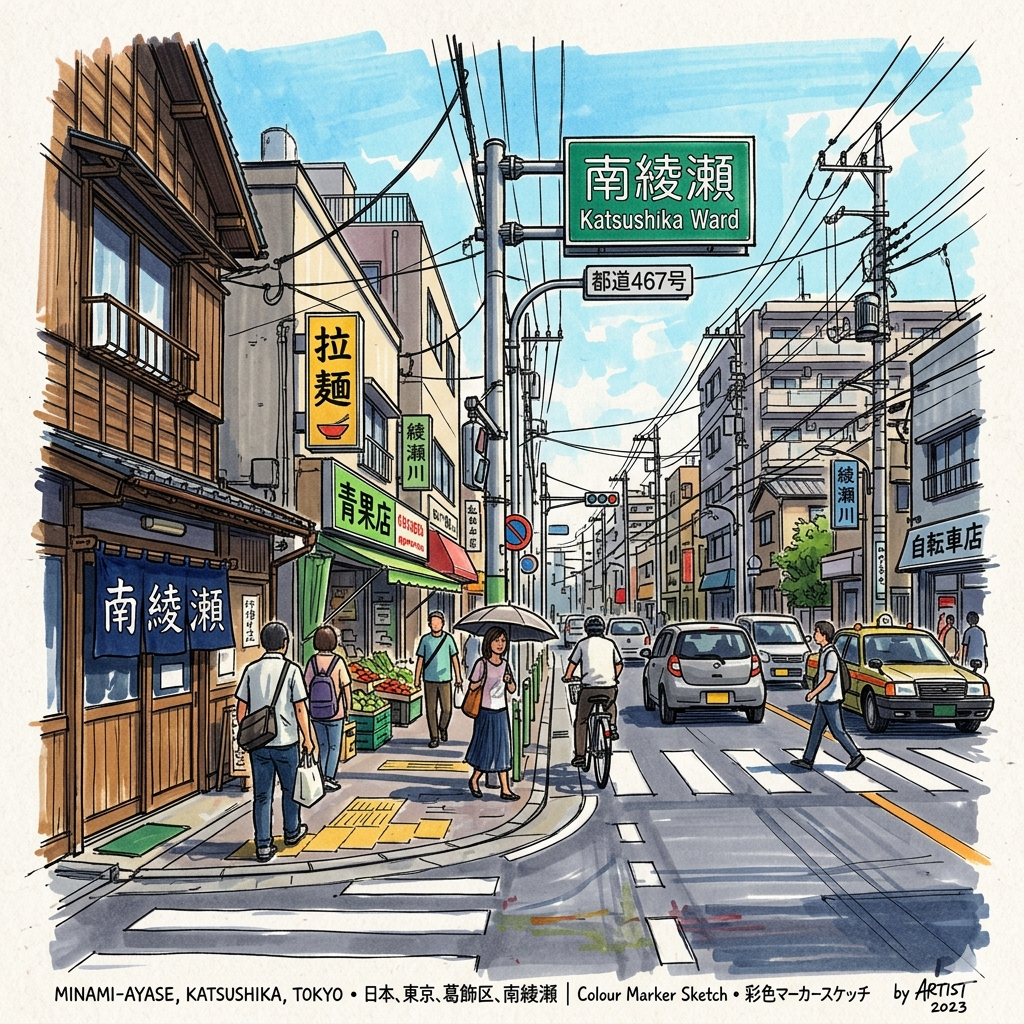
In the contemporary landscape of East Tokyo, the district formerly known as Minami-Ayase—encompassing modern-day Kosuge, Horikiri, and Yanagihara—often presents itself as a quiet residential periphery. However, a closer reading of its topography reveals a historical powerhouse. Situated at the strategic confluence of the Ayase and Naka Rivers, this alluvial plain served for centuries as a vital theater for hydraulic engineering, state authority, and modern infrastructure. From the administrative governance of the Shogunate’s bureaucrats to the industrial fires of the Meiji era, the area’s identity has been forged by its role as a functional heart for the capital. Today, this history remains legible to the observant traveler, etched into the straight lines of its canals and the imposing silhouettes of its state architecture. To understand this modern cityscape, one must first look at the family that literally carved the land from the water.
Listen to the historical stories told in detail (For subscribers only)
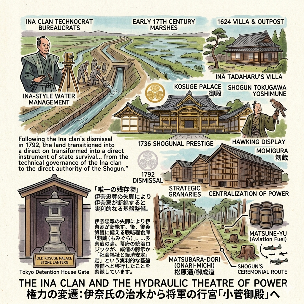
The Ina Clan and the Hydraulic Theatre of Power
In the early 17th century, the marshes of Kosuge were transformed into a political waypoint by the Ina clan. Serving as Kanto Gundai (Regional Deputies), the Ina were more than mere administrators; they were "technocrat-bureaucrats" who mastered the "Ina-style" of water management. Their ability to tame the chaotic river systems of the Kanto Plain provided the agricultural stability necessary for the Tokugawa Shogunate to thrive.
The site’s evolution reflects a steady increase in strategic importance. In 1624, it began as an administrative outpost and villa for Ina Tadaharu. By 1736, under Shogun Tokugawa Yoshimune, it was elevated to the "Kosuge Palace," a site for hawking and a display of Shogunal prestige. Following the Ina clan’s dismissal in 1792, the land transitioned into a direct instrument of state survival. In 1807, the Shogunate established the Momigura, massive strategic granaries designed to stabilize rice prices and mitigate the threat of famine in Edo. This shift—from the technical governance of the Ina clan to the direct authority of the Shogun—reflects the broader centralization of power during the Edo period. The land was no longer just a managed swamp; it was a physical manifestation of the Shogunate’s control over both nature and the economy.
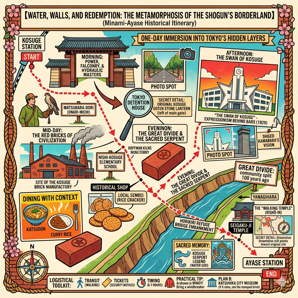
Evidence of this era persists in the rigid geometry of the landscape. The Old Kosuge Palace Stone Lantern, located inside the current Tokyo Detention House gate, is the sole physical remains of the palace gardens. Nearby, Matsubara-dori (Onari-michi) serves as a poignant reminder of these layers. This straight path once served as the ceremonial route for the Shogun, lined with pine trees planted by the second Shogun, Hidetada. In a tragic twentieth-century overlay, these ancient trees were harvested during World War II to produce matsune-yu (aviation fuel), leaving the straight path as a haunting echo of both Edo prestige and wartime desperation.
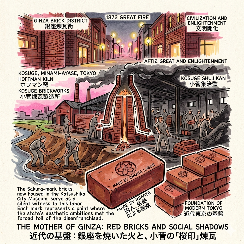
The Mother of Ginza: Red Bricks and Social Shadows
The Great Ginza Fire of 1872 catalyzed a desperate state-led movement toward "non-combustible" urbanism. To rebuild the capital in stone and brick, the Meiji government required an industrial source of immense scale. Kosuge, with its rich alluvial clay and easy river access, became the "industrial womb" for modern Tokyo. In 1872, the first state-run brick factory was established here, featuring the revolutionary "Hoffman Kiln," which allowed for continuous, large-scale production. These bricks, stamped with a "Sakura-mark" (cherry blossom), became a signature of state-sanctioned quality, forming the foundations of the Ginza Brick District.
There is a profound structural violence in this era of "Civilization and Enlightenment." The luxury and safety of central Tokyo were built on the labor of the marginalized. By 1879, the brickworks were integrated with the Kosuge Shujikan (prison), where inmates labored in harsh, soot-filled conditions to produce the materials for the capital’s modernization.
"The Sakura-mark bricks, now housed in the Katsushika City Museum, serve as a silent witness to this labor. Each mark represents a point where the state's aesthetic ambitions met the forced toil of the disenfranchised."
As the brick kilns fell during the 1923 earthquake, a new form of "enlightened" architecture rose from the debris.
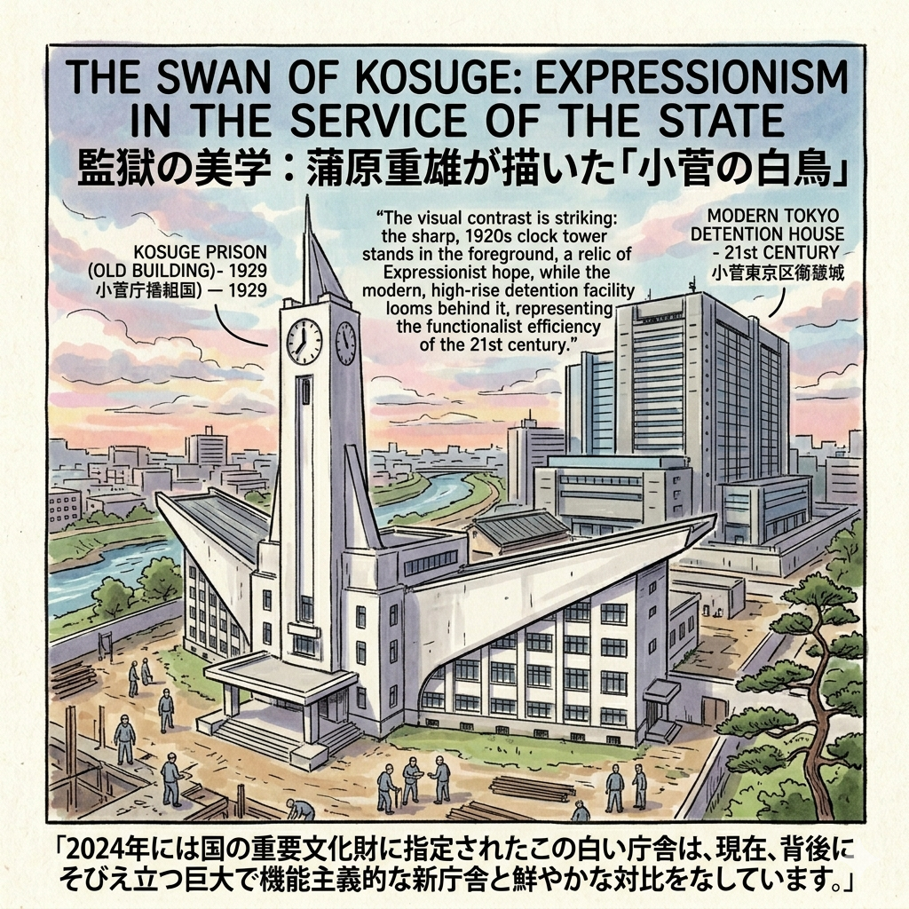
The Swan of Kosuge: Expressionism in the Service of the State
The reconstruction following the 1923 earthquake coincided with a paradigm shift in Japanese penology, moving from punishment toward "correction and education." This humanitarian shift found its physical expression in the work of architect Kabara Shigeo. In 1929, Kabara completed the new Kosuge Prison building. Designed in the "Expressionist" style, the structure was a radical departure from the dark, oppressive jails of the past. Its sharp angles, white concrete, and soaring silhouette earned it the moniker "The Swan of Kosuge."
However, the beauty of the building is tinged with tragedy. This was Kabara Shigeo’s only major work; the architect died of tuberculosis at the age of 34, shortly after its completion. His "Expressionist hope" is frozen in the concrete, creating a haunting irony: a "beautiful prison" where avant-garde aesthetics mask a mechanism of absolute control. The act of prisoners building their own place of "reformation" under Kabara’s direction serves as a profound social performance. In 2024, this structure was designated a National Important Cultural Property.
"The visual contrast is striking: the sharp, 1920s clock tower stands in the foreground, a relic of Expressionist hope, while the modern, high-rise detention facility looms behind it, representing the functionalist efficiency of the 21st century."
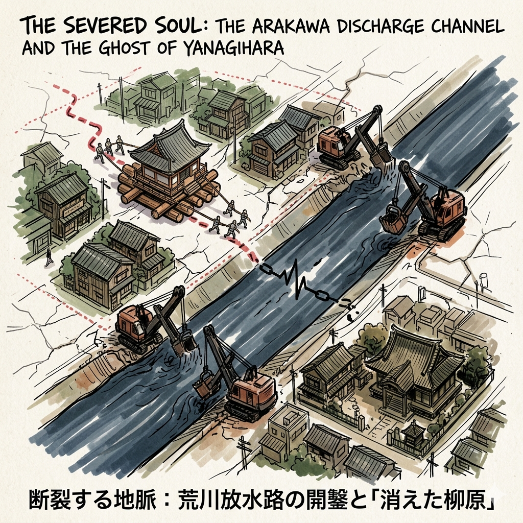
The Severed Soul: The Arakawa Discharge Channel and the Ghost of Yanagihara
Following the catastrophic Great Flood of 1910, the Meiji government initiated a "geo-surgical" intervention: the Arakawa Discharge Channel. Constructed between 1911 and 1930, this 500-meter-wide artificial river was designed to protect the capital’s center by diverting floodwaters. The cost of this downstream safety was the bisection of the Minami-Ayase community. Families were displaced, and the district of Yanagihara was physically cut off from its administrative center in Katsushika.
This history highlights the cold logic of "functionalism vs. history." To save the "center," the state was willing to erase the "historical veins" of the periphery. By 1934, the geographic isolation was so severe that Yanagihara was officially annexed by Adachi. This caused a profound "emotional tearing" for residents who were suddenly separated from their schools and ancestral community. The story of the temple Risho-in serves as a symbol of local resistance; rather than being demolished, the temple was moved two kilometers on logs to its current location—a "walking temple" that preserved its identity against the state’s massive earth-moving machines.
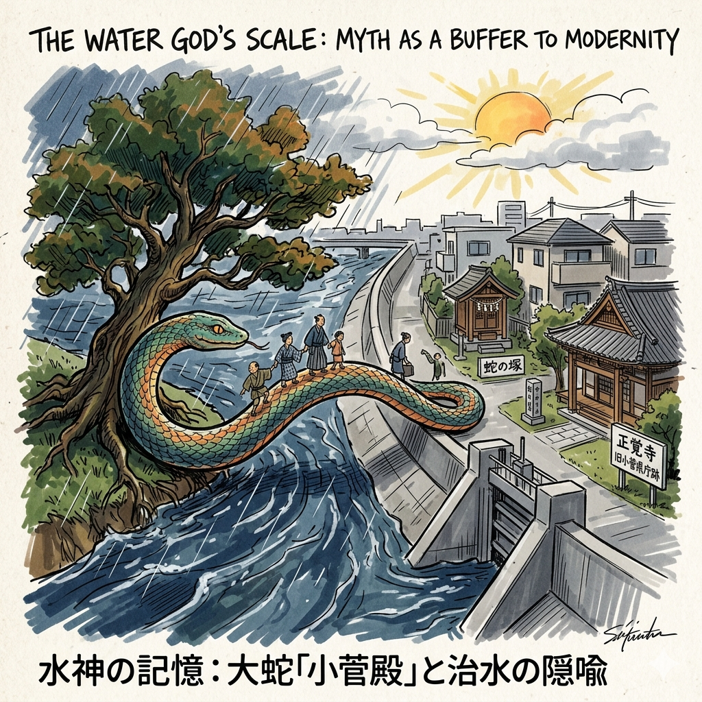
The Water God’s Scale: Myth as a Buffer to Modernity
For the residents of a flood-prone district, water was not just a threat; it was a deity. In the shadow of the Ina clan’s engineering, local myths emerged as a way to process environmental trauma. The central legend is that of "Kosuge-dono," a benevolent serpent living beneath a great Enju tree. According to myth, the serpent transformed its body into a bridge of scales to save villagers during a violent flood.
This myth serves as a personification of the river’s power and the hydraulic engineering that sought to tame it, allowing locals to maintain a spiritual connection to their land amidst the state’s cold, concrete reality. Seigaku-ji Temple remains the repository for these legends. Its history is doubly significant, as it also served as the temporary Kosuge Prefectural Office, marking a unique intersection of spiritual myth and secular governance.
Walking the Layers: A Traveler’s Framework
For the modern traveler, the Minami-Ayase/Kosuge area is best experienced as a "layered observation." Begin at the formidable walls of the Tokyo Detention House to witness the legacy of the Ina clan and the Expressionist towers of Kabara Shigeo. From there, walk toward the banks of the Arakawa, paying attention to the "unnatural" straightness of the canals—a sign of the state's geo-engineering. Look for the "unseen" boundaries where one district ends and another begins, a result of the river being forced through the neighborhood.
The final destination should be the Katsushika City Museum (Local History Section). Here, the abstract history becomes material. You can view the actual "Sakura Bricks" and explore the archives of the Ina clan, providing a material connection to the labor and leadership that built the district.
Collective Reflection: The Turning Wheel of Minami-Ayase
The history of Minami-Ayase reveals four recurring patterns: the technocratic control of nature, the symbiosis of capital and punishment, the use of myth as a social shield, and a persistent "marginality" that supports the "center." Whether it was providing grain for Edo, bricks for Ginza, or flood protection for the modern metropolis, this district has always carried the weight of the city on its back. As we look at the massive high-rise detention tower and the engineered rivers of today, we must ask: what modern infrastructure are we building now that might be viewed as a "prison" or a "palace" by travelers 100 years from now?
To dive deeper into Tokyo's hidden hydrological histories, subscribe to our monthly field notes.
Exploring the Ayase Frontier (Travel Logistics)
- How to Get There: Take the Chiyoda Line or the JR Joban Line to Kosuge Station. Most historical sites are within a 10–15 minute walk from the station.
- Recommended Tours: Look for walking tours focused on "Shitamachi Industrial Heritage" or "River Infrastructure," which often include visits to the Arakawa embankments.
- Nearby Accommodation: Consider staying near Kita-Senju. As a major transit hub, it offers easy access to the historical layers of both the Ayase and Arakawa regions while maintaining a classic Shitamachi atmosphere.
Q & A
How did the Shogun's palace evolve into a modern prison?
The evolution of the Shogun’s palace in Minami-Ayase-machi (specifically the Koshige area) into a modern prison reflects Japan’s broader transition from a feudal society to a modernized state. This transformation occurred through several distinct stages of administrative, strategic, and architectural shifts.
1. From Administrative Outpost to Shogun’s Palace (1624–1792)
The site’s importance began in 1624, when the third Shogun, Tokugawa Iemitsu, granted the land to Ina Tadaharu, the Kanto Gundai (regional administrator), to use as a secondary residence. Because it sat at the intersection of the Ayase River and the Mito Highway, it served as a strategic hub for flood control and regional governance.
In 1736, under the eighth Shogun, Tokugawa Yoshimune, the site was officially upgraded to a palace named Koshige Goten (also known as Senju Goten). It was used as a base for the Shogun’s falconry (hunting) activities and as a display of Shogunal authority. The ninth Shogun, Tokugawa Ieshige, further utilized the palace as a site for recuperation and vacation.
2. Transition to Strategic Infrastructure (1792–1868)
The palace era ended in 1792 when the Ina family was dismissed for mismanagement, leading to the demolition of the palace buildings. During the late Edo period, the site shifted toward functional state use:
- Strategic Granary: In 1807, massive grain storehouses (Momigura) were built to manage rice supplies and stabilize the economy during famines.
- Minting Center: In 1860, the Koshige Zeniza (mint) was established there to produce iron coins during a period of fiscal crisis.
3. The Industrialization of Punishment (1872–1879)
Following the Meiji Restoration, the site became a laboratory for modernization. After the 1872 Ginza fire, the government established the Koshige Brick Factory, Japan’s first state-owned modern brick plant, to produce building materials for a westernized "brick city" in Tokyo.In 1879, the Ministry of Home Affairs acquired the factory and established the Koshige Shujikan (Prison). This marked the formal birth of the prison, merging prisoner labor with industrial production. Inmates worked in harsh conditions to manufacture bricks—identifiable by a central "cherry blossom" stamp—which were used to build the foundations of modern Tokyo, such as the Tokyo Station.
4. Rebirth as "The Swan of Koshige" (1923–1929)
The final stage of its evolution into a modern facility followed the 1923 Great Kanto Earthquake, which destroyed the original brick prison structures. The reconstruction project (completed in 1929) was led by a young architect, Shigeo Kabara, who introduced a revolutionary aesthetic and functional approach:
- Aesthetic Shift: Influenced by European Expressionism, Kabara designed a white, geometric structure with sharp angles and folding lines. From above, the building resembled a white bird in flight, earning it the nickname "The Swan of Koshige".
- Modern Penology: The design replaced the dark, oppressive atmosphere of traditional prisons with a focus on ventilation, light, and "educationalism," aiming to reform rather than just punish.
Today, while the site has been further modernized as the Tokyo Detention House, the 1929 building remains preserved as a National Important Cultural Property, standing as a monument to the intersection of state power, industrial labor, and architectural innovation.
How did massive river construction projects change local district boundaries?
Massive river construction projects, specifically the excavation of the Arakawa Drainage Channel (1911–1930), fundamentally altered local district boundaries by physically bisecting communities and forcing administrative realignments based on geographical accessibility.
The transformation occurred in the following ways:
- Physical Bisection of Districts: The construction of the artificial 500-meter-wide Arakawa Drainage Channel was designed to protect Tokyo from flooding after the catastrophic "Great Flood of Gengxu" in 1910. This "landscape surgery" cut the original Minami-Ayase-machi (which included Yanagihara, Koshige, and Horikiri) into two separate parts, creating a massive artificial barrier between previously unified neighborhoods.
- The Transfer of Yanagihara (1934): The most prominent example of boundary change was the reassignment of the Yanagihara area. Originally a part of Katsushika District, Yanagihara became geographically isolated from the rest of the district by the new channel. Residents, including schoolchildren, were forced to use ferries or take 3-kilometer detours to reach the center of Katsushika, which became dangerous during flood seasons.
- Administrative Realignment for Functionalism: Due to this physical isolation, Yanagihara was officially removed from Katsushika District and incorporated into Adachi District in 1934. This "territorial transfer" reflected a shift toward "functional priority" in urban planning, where administrative boundaries were redrawn to match the new physical reality of the landscape, even at the cost of erasing historical local identities.
- Engineering as a Tool of Power: These projects demonstrated how state power used massive civil engineering to reorganize not just the natural environment, but also the legal and administrative limits of local governance. The straightening of the river effectively "redistributed power" and redefined the legitimacy of administrative divisions based on the newly created waterways.
This history shows that the wide, straight lines of the Arakawa River seen today are actually "artificial scars" that mark the points where local districts were forcibly severed and reorganized for the sake of modern urban flood management.
Reference and Further reading
- 第95回 文化財めぐり - 葛飾区郷土と天文の博物館, 檢索日期:4月 20, 2026,
- 小菅探訪~塀の町の歴史の残影~ =小池和栄 - 穂高健一ワールド, 檢索日期:4月 20, 2026,
- やまだくんのせかい : 小菅御殿 メモ - 山田君の世界, 檢索日期:4月 20, 2026,
- 【た】 鷹狩に 将軍通った 小菅御殿|葛飾区公式サイト, 檢索日期:4月 20, 2026
- 赤山街道 小菅御殿・御成道・煉瓦製造所 - 歴史探訪と温泉 - FC2, 檢索日期:4月 20, 2026,
- 葛飾区Kitshushika 檢索日期:4月 20, 2026,
- 葛飾区史|第3章 地域の歴史, 檢索日期:4月 20, 2026,
- 東京拘置所 - 檢索日期:4月 20, 2026,
- 葛飾区史|第5章 暮らしの移り変わり, 檢索日期:4月 20, 2026,
- 葛飾区史|第3章 地域の歴史, 檢索日期:4月 20, 2026,
- 現在の東京拘置所はかつて煉瓦製造所だったと聞いた。その成り立ちとその後の変遷について知りたい。 | レファレンス協同データベース, 檢索日期:4月 20, 2026,
- 【伊奈氏シリーズその5】旧小菅御殿(東京都葛飾区) - 中央区観光協会特派員ブログ, 檢索日期:4月 20, 2026,
- レンガ工場 - 東京 - 葛飾区史|第2章 葛飾の歴史, 檢索日期:4月 20, 2026,
- 綾瀬の街の特徴や歴史について解説 - 東京事務所探しプラス, 檢索日期:4月 20, 2026,
- 東京拘置所と煉瓦工場 | Tokyo Detention House and brick factory | かつしかあつめ ブログ, 檢索日期:4月 20, 2026,
- 第3章 近代化への道(明治~戦前) - 葛飾区, 檢索日期:4月 20, 2026,
- 土木遺産㊽ 多大な努力で復元された「ホフマン式輪窯」, 檢索日期:4月 20, 2026,
- 第二海堡の煉瓦構造物の特徴, 檢索日期:4月 20, 2026,
- 国指定重要文化財 The Nogi Town Circular Brick Kiln - 野木町煉瓦窯, 檢索日期:4月 20, 2026,
- 岩淵水門が示した「コンクリートの威力」 - 荒川知水資料館 amoa, 檢索日期:4月 20, 2026,
- 旧小菅刑務所を見に行く - 東京建築散歩, 檢索日期:4月 20, 2026,
- 旧小菅刑務所庁舎 | 佐藤総合計画, 檢索日期:4月 20, 2026,
- 9138 蒲原重雄による行刑建築への衛生思想の適用に関する研究 : 旧東京拘置所房舎の実測調査による検証を通して(保存:近代(1),建築歴史・意匠) - 日本建築学会, 檢索日期:4月 20, 2026,
- 明治43年大洪水 - 関東地方整備局, 檢索日期:4月 20, 2026,
- 荒川放水路変遷誌[PDF - 関東地方整備局 - 国土交通省, 檢索日期:4月 20, 2026,
- 知っていますか?荒川放水路のこと「荒川放水路通水100周年」 - 足立区, 檢索日期:4月 20, 2026,
- 中川(中川放水路)の歴史と風景 - 江戸川フォトライブラリー, 檢索日期:4月 20, 2026,
- 明治・大正・昭和期に行われた荒川放水路開削工事と 市民の生活, 檢索日期:4月 20, 2026,
- 荒川下流域(荒川放水路 岩渕水門~0Kmまで)を歩く | 山の風音, 檢索日期:4月 20, 2026,
- 葛飾区史|第5章 暮らしの移り変わり, 檢索日期:4月 20, 2026,
- 江戸史蹟散歩 小菅御殿, 檢索日期:4月 20, 2026