(ENG) Tsurumi-ku, Osaka: Navigating the Strata from Ancient Wetlands to World Expo
Explore the hidden layers of Tsurumi-ku, Osaka. From the Mononobe Clan and 1917 Great Flood to the 1990 Flower Expo, discover a city built on reclaimed time.


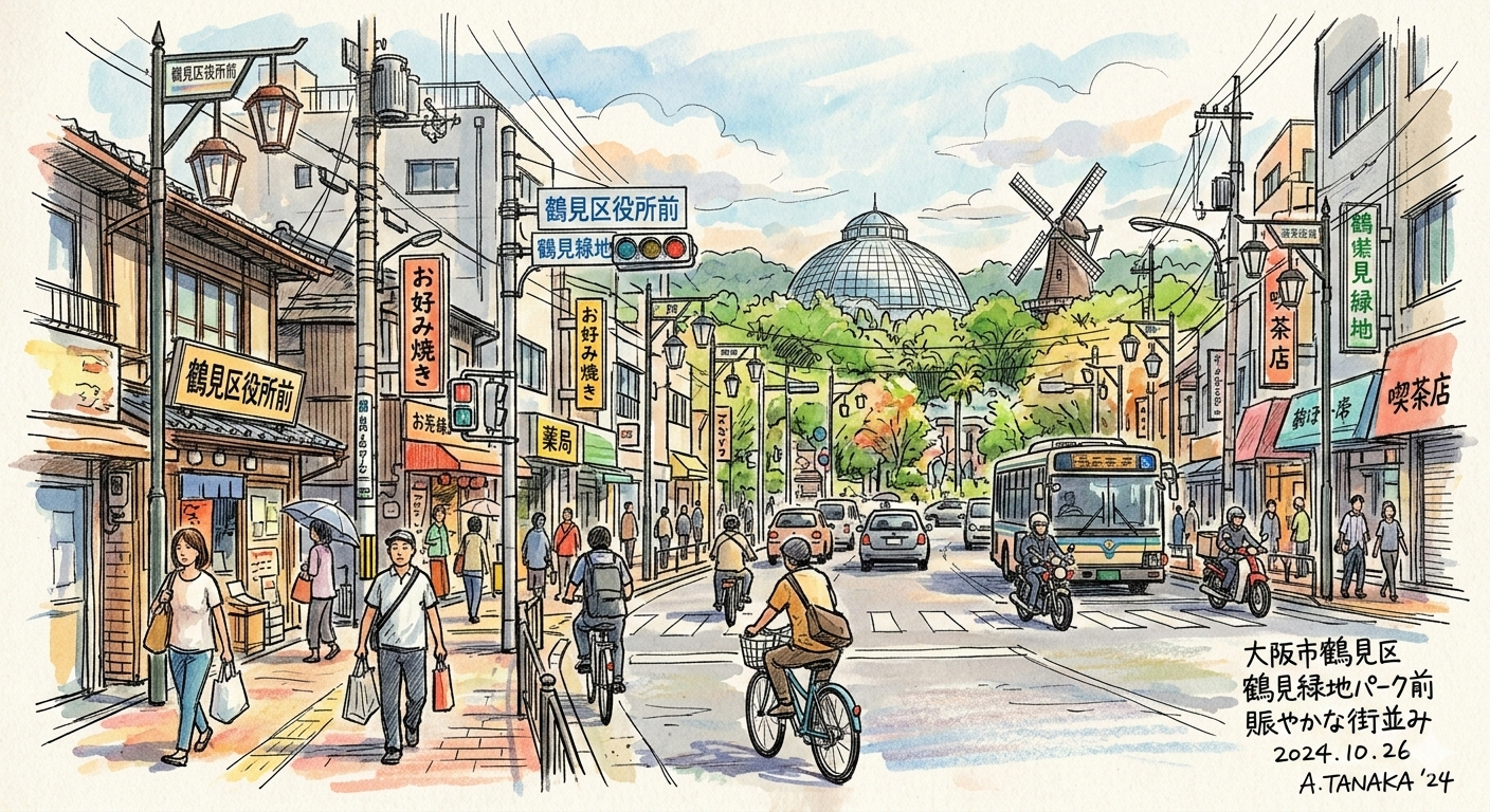
How did Tsurumi Ryokuchi Park transform from a landfill?
What are the unique cultivation techniques for "Hanoi lotus root"?
How did the 1917 flood reshape this region's development?
To walk the streets of Tsurumi-ku today is to traverse a landscape of profound, deliberate transformation. Located in the northeastern reach of the Osaka Plain, this district does not reveal itself through a single identity but rather through a vertical stack of geological and social layers. It is a place defined by the mastery of water and the reclamation of waste—a journey from the ancient, muddy periphery of the Kawachi Lake to the manicured greenery of a world exposition site.
Understanding Tsurumi requires looking beyond its modern façade of residential blocks and parklands. It is a site of "spatial exploration" where the past is not merely behind us, but literally beneath our feet. This is not a finished city, but a series of geological and social strata that can still be felt on a quiet walk today. From the labor-intensive lotus fields of the Edo period to the high-tech engineering of the late 20th century, Tsurumi serves as a testament to human resilience against an unstable environment. To truly see this place, one must first step back into the primordial mud of its origins.
Listen to the historical stories told in detail (For subscribers only)
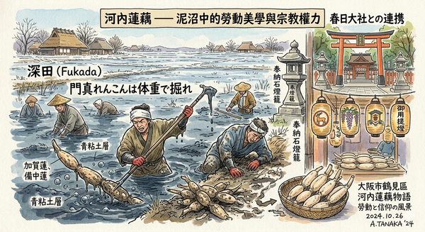
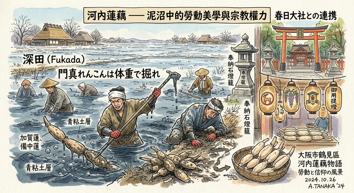
The Labor Aesthetics of the Kawachi Lotus
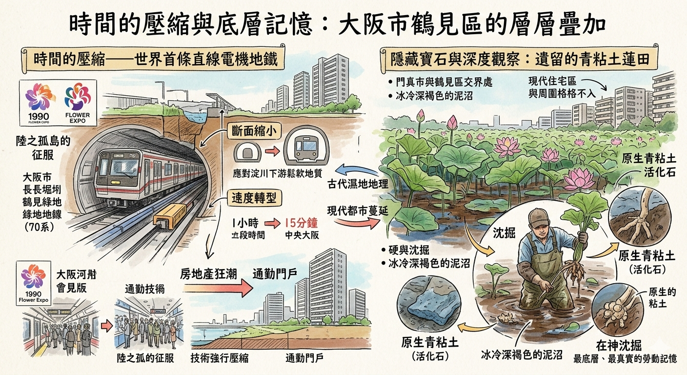
Long before Tsurumi was a suburb, it was a world of shinden—"deep fields" of treacherous mud and standing water. Because the terrain was so low-lying and prone to the flooding of the Yodo and Yamato rivers, traditional rice farming was often a losing battle. In this marginal environment, the local population turned to a specialized form of survival: the cultivation of the Kawachi Lotus.
This was a "marginal adaptation" to a hostile landscape. The secret lay in the "blue clay layer," a rich, iron-heavy soil that produced lotus roots of exceptional texture. However, harvesting them required the Shizumibori (submerged digging) technique, a grueling process where farmers worked in near-freezing water during the winter months.
門真れんこんは体重で掘れ
Dig Kadoma lotus with your body weight
This local maxim captures the physical reality of the work; farmers had to submerge themselves and use their entire body weight to press through the heavy clay. Yet, the challenge was not merely physical. The powerful "Tenma Merchants" of Osaka initially avoided the lotus, superstitious that its internal holes symbolized "holes in business" or financial loss. To bypass this market barrier and the threat of mountain bandits, farmers forged an alliance with the Kasuga Taisha shrine in Nara. By carrying "Goyo Chochin" (official lanterns) bearing the shrine’s crest, they leveraged religious authority as a sophisticated branding tool, granting them safe passage and commercial legitimacy. This prosperity, however, was nearly erased by the sheer force of nature.
The Great Flood and the Remaking of Space
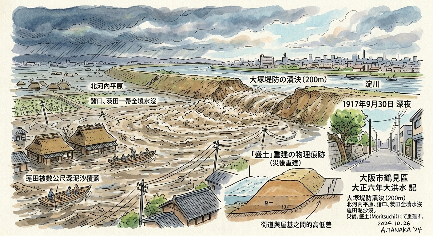
In 1917 (Taisho 6), the fragility of Tsurumi's geography was laid bare. A massive typhoon triggered what is now known as the Great Flood, leading to the catastrophic collapse of the Otsuka Embankment. The resulting deluge turned the entire region into an inland sea—a state described in historical records as ouyou (汪洋), a vast, borderless ocean of silt.
The disaster acted as a "spatial reset." The destruction of the lotus fields forced a radical shift in the social structure, as many tenant farmers were pushed into the industrial urban workforce of central Osaka. This transition was physically manifested in the reconstruction of the land itself.
Pre-Flood Wetland Landscape | Post-Flood Urban Reconstruction |
Vulnerable, low-lying mudflats; Moroguchi and Matta as a "vast sea" (ouyou). | Introduction of moritsuchi (raised earth) foundations for stability. |
Dispersed rural settlements centered on submerged shizumibori labor. | Organized urban planning; industrial-adjacent residential zones. |
Natural, unpredictable drainage patterns across the Kawachi basin. | Modernized embankments and high-capacity drainage systems. |
Even today, the "scars" of this reconstruction are visible in the varying elevations of the streets. Traditional settlements often sit on slightly higher ground—the physical residue of a community that literally raised itself out of the mud.
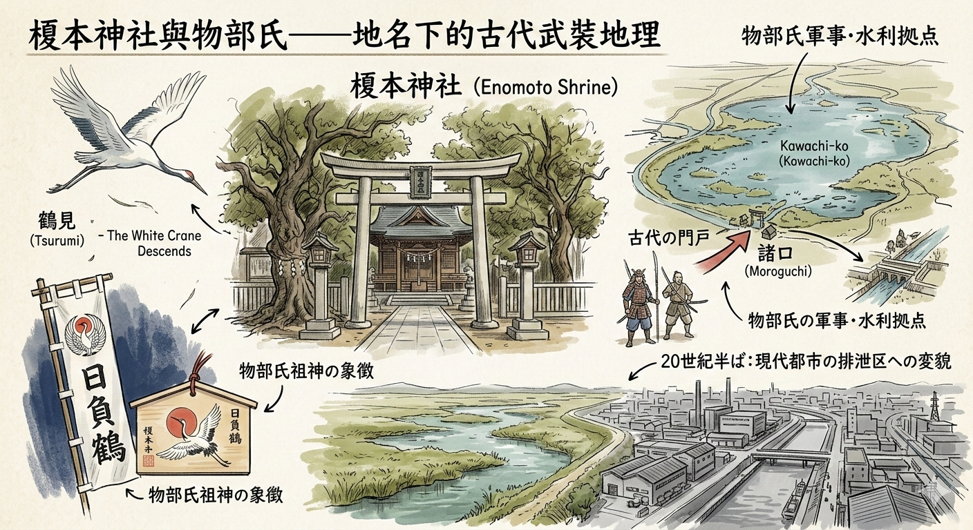
The Mononobe Clan and the Myth of the Crane
The name "Tsurumi" is often romanticized as "crane-watching," but its roots are far more grounded in the ancient power dynamics of the Kawachi Lake. The area served as a "Moro-guchi" or gateway, a strategic military and irrigation stronghold for the Mononobe Clan, an elite lineage of warriors and ritualists from the 5th and 6th centuries.
The Enomoto Shrine remains the spiritual anchor of this history. The myth of a "white crane" descending to this spot was a masterful form of "religious branding." By associating the land with a divine messenger, the Mononobe lineage legitimized their control over the vital water-access points to the Kawachi basin. Travelers visiting the shrine can still find the Higurashi-no-Tsuru crest, a specific crane motif that distinguishes this site from generic imagery. It is a reminder that this "new" district was once the threshold of a powerful ancient state. Over time, however, these sacred gateways would find themselves bordering the metabolic waste of a modernizing metropolis.
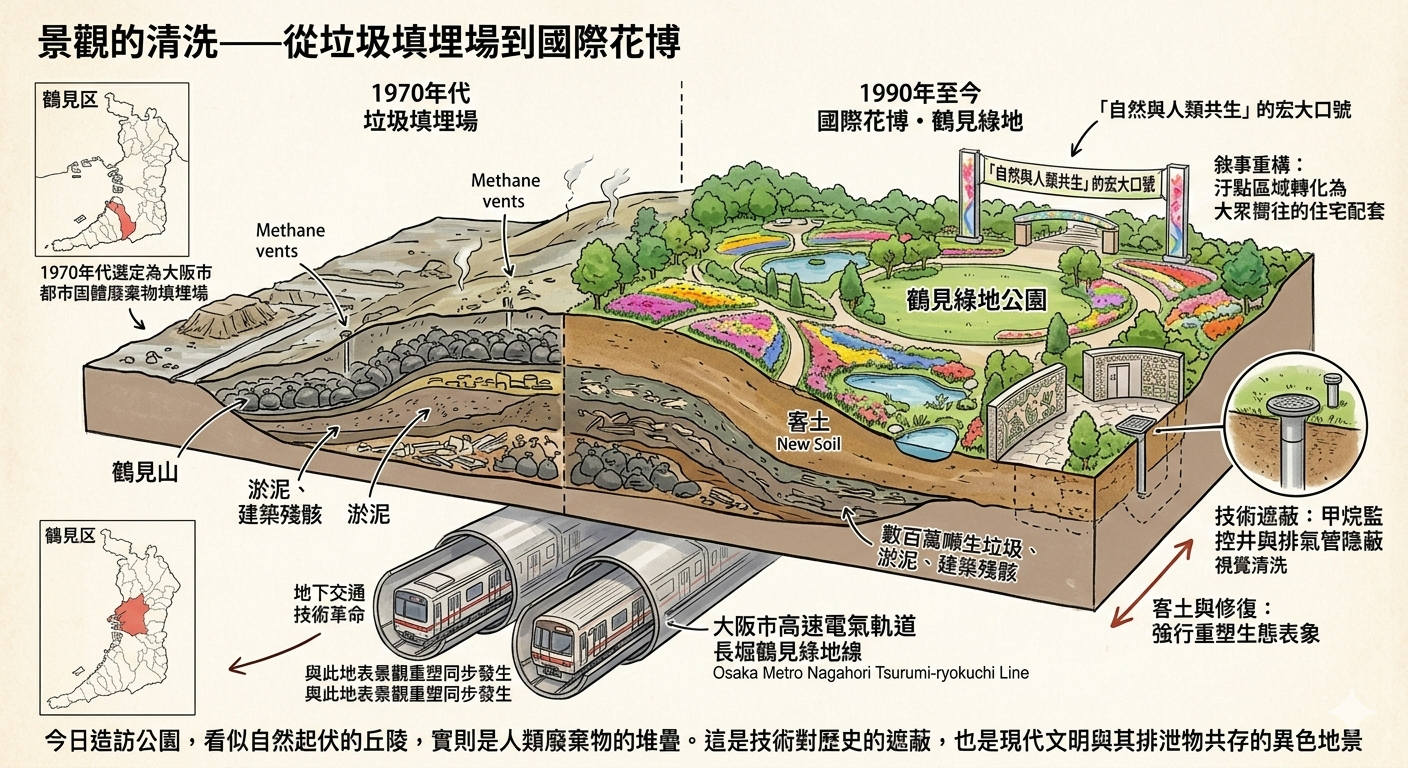
Landscape Alchemy: From Landfills to the 1990 Expo
By the mid-20th century, Tsurumi's low-lying history made it a candidate for Osaka's "metabolic dumping ground." From 1972, the area that is now Tsurumi Ryokuchi Park was a massive landfill for solid waste and sewage sludge. The most prominent physical monument to this era is Tsurumi-yama, a man-made hill composed entirely of urban waste and sludge.
The transformation of this site for the 1990 International Garden and Greenery Exposition is a masterclass in "Landscape Washing." The city masked decades of ecological trauma with a "natural" aesthetic, covering the waste with layers of fresh soil and botanical gardens. While the park is now a site of leisure, the "modern ruins" of its landfill past remain. Small methane vent pipes and monitoring wells are hidden behind modern facilities, quietly venting the gases still produced by the decomposing history deep underground. Tsurumi-yama stands not as a natural peak, but as a monument to the 20th century’s urban metabolic waste, hidden under a thin veneer of greenery.
Compressing Time with the Linear Motor Subway
The final layer of Tsurumi’s evolution was the technological solution to its isolation. Long regarded as a "land island" due to its soft soil, the district was finally integrated into the city via the Nagahori Tsurumi-ryokuchi Line. This was the world’s first commercial linear motor subway. The technology allowed for smaller tunnels and steeper climbs—essential for navigating the unstable, water-logged strata of the district.
This innovation achieved a "time compression," turning a journey that once took an hour into a fifteen-minute commute. If you travel to Tsurumi-ryokuchi Station today, notice the smaller car sizes and the notably lower platform ceilings—physical evidence of the engineering constraints required to tunnel through the fragile Kawachi wetlands. Contrast this engineering pragmatism with the station’s mosaic murals; these vibrant artworks remain as a "frozen layer" of 1990s optimism, depicting a "future city" that stands in stark tension with the methane vents just a few meters above.
Hidden Gems for the Historical Traveler
- Enomoto Shrine (Moroguchi): A quiet, atmospheric site preserving the Kasuga-zukuri architectural influence. Look for the ancient crane crests that link the site to the Mononobe clan’s strategic gateway.
- The Remaining Lotus Fields: Located near the border of Kadoma, these small plots are "living fossils," the only places where one can still see the original blue clay environment that defined the regional economy.
Philosophical Synthesis & Conclusion
Tsurumi-ku exists as a profound dialogue between nature’s inherent instability and the relentless drive of human engineering. It is a place where the landscape has been repeatedly erased and rewritten. The mud was replaced by lotus fields; the floods replaced the farmers with workers; the garbage was buried under an international garden. This cycle of burying the past to create the future is the defining characteristic of the district.
When we walk through the botanical beauty of the Tsurumi Ryokuchi, we are standing on the compressed waste of the 20th century, which in turn sits atop the silt of the Taisho flood, which rests upon the ancient gateways of the Mononobe. There is a persistent tension here—a sense that the "nature" we see is a carefully maintained illusion, held in place by methane vents and linear motor technology.
It prompts a necessary question: what happens to the identity of a place when its history is so thoroughly layered and concealed? Tsurumi suggests that the "soul of a place" is not found in its manicured surface, but in the friction between those layers. To travel here is to realize that the ground beneath us is never truly solid; it is a living, breathing archive of everything we have tried to overcome.
Subscribe for more "Historical Travel Stories" and explore the layered narratives of the world’s most transformative spaces.
Practical Appendix: Reaching the Layers
How to get there: Take the Osaka Metro Nagahori Tsurumi-ryokuchi Line to Tsurumi-ryokuchi Station. Pay close attention to the smaller tunnel dimensions and the Expo-era mosaic art at the stations, particularly at Kyobashi and the terminus, which reflect the "Future City" optimism of 1990.
Recommended Accommodation: Stay in the Kyobashi area, a vibrant hub that serves as the gateway to the Tsurumi line. It offers a blend of modern convenience and older, post-war Osaka charm.
Recommended Tours:
- The Wetland Walk: A self-guided walking tour starting from Enomoto Shrine through the older residential clusters of Moroguchi to see the moritsuchi (raised earth) foundations.
- Botanical History Tour: A visit to the Sakuya Konohana Kan (Great Conservatory) in the park, which represents the pinnacle of environmental control on a site that was once a landfill. Observe the methane monitoring wells on the walk toward the conservatory.