Tsing Yi Island: The Gods Who Refused to Leave
Everyone knows Tsing Yi as the island the bridge passes over. Almost no one knows it as the island where a Song-dynasty pirate-hunter and a Fujianese sea-goddess have spent a century negotiating, with their own displaced worshippers, how to keep a promise.

 Lawrence
I lived in Tsing Yi for a time—specifically at "Mayfair Gardens," the place mentioned in the fifth story of the text—and it left a deep impression on me.
The Island Everyone Drives Past
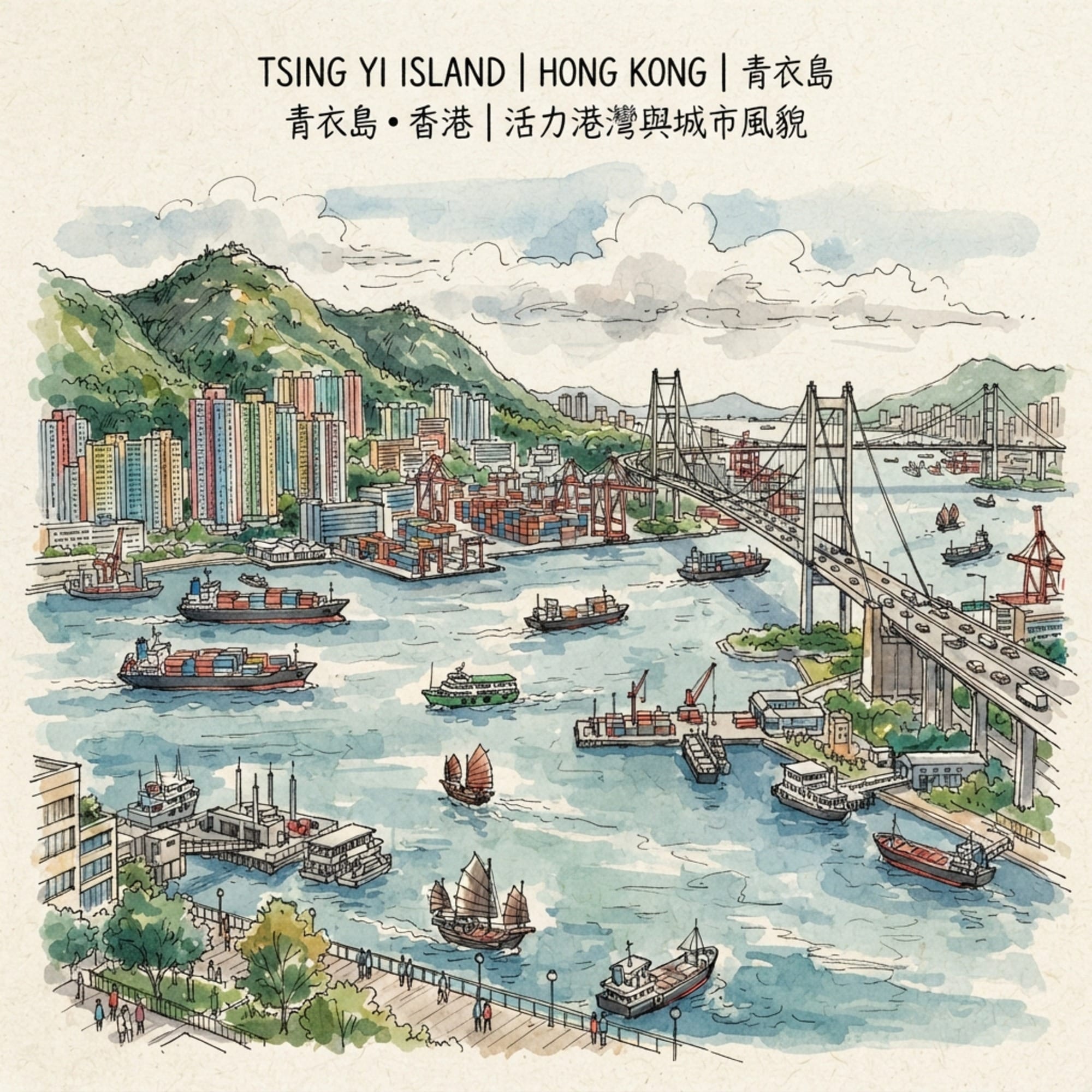
Most people who have been to Hong Kong have technically visited Tsing Yi without knowing it. It's the landmass the Tsing Ma Bridge launches from, the industrial blur you glimpse from the Airport Express, a name on a container terminal manifest. What almost no visitor sees is that this same island has spent four hundred years being fought over, bombed, reclaimed, poisoned, and rebuilt — and that through every single one of those upheavals, its residents kept doing the same thing: they moved their gods, rather than lose them. A sea-goddess and a pirate-hunting deity have each been relocated at least twice in living memory, and neither has ever, according to the people who tend their altars, missed a single day on the job. That is the story the container terminals don't tell you.
Listen to the historical stories told in detail (For subscribers only)
A Ming Battle in Water That No Longer Has a Name
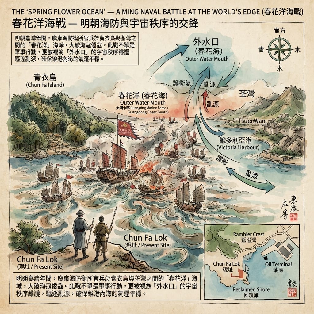
Before it was Tsing Yi, this stretch of sea was called Chun Fa Yeung — the Ocean of Spring Flowers — and it shows up in Ming-dynasty government charts as the site of a naval engagement between imperial forces and a pirate fleet. We don't know the commander's name. We don't know the year with any precision. What we know is that somewhere in these waters, off what's now the island's southeastern tip, a battle happened that mattered enough to get written down, and then largely forgotten — filed under an administrative record rather than a legend, the way most real history is.
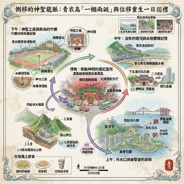
The island itself was once known as Chun Fa Lok, "the Fall of Spring Flowers," a name Western charts rendered as "Chun Fa Island." That name still clings to the southeastern shoreline today, wedged between the Sai Tso Wan oil depot and the Rambler Crest housing estate — both built on land that used to be open sea. Stand on what's left of that promontory and look southwest: Rambler Channel stretches out toward the wider Pearl River Delta, the air carrying oil-terminal sharpness, salt off the tide, and — on a clear day — a faint green note drifting down from the forest on Tsing Yi Peak. The granite under your feet was there for the battle. Almost nothing else was.
Sealing The Ocean Of Spring Flowers
In the region's own cosmological grammar, this stretch of water functioned as an "outer water mouth" — the seam where the sheltered inner harbour meets the open sea, and therefore the single most exposed point in the whole system. It is the place where protective energy is most likely to leak out, and where hostile forces are most likely to get in. A naval clean-up here wasn't just tactics. In the logic of the people who lived by these waters, it was a resealing of the harbour's edge at its weakest seam — which is possibly why, six hundred years later, this same coastline kept attracting trouble that needed a supernatural answer.
The Workers Who Carried a God Across the Water
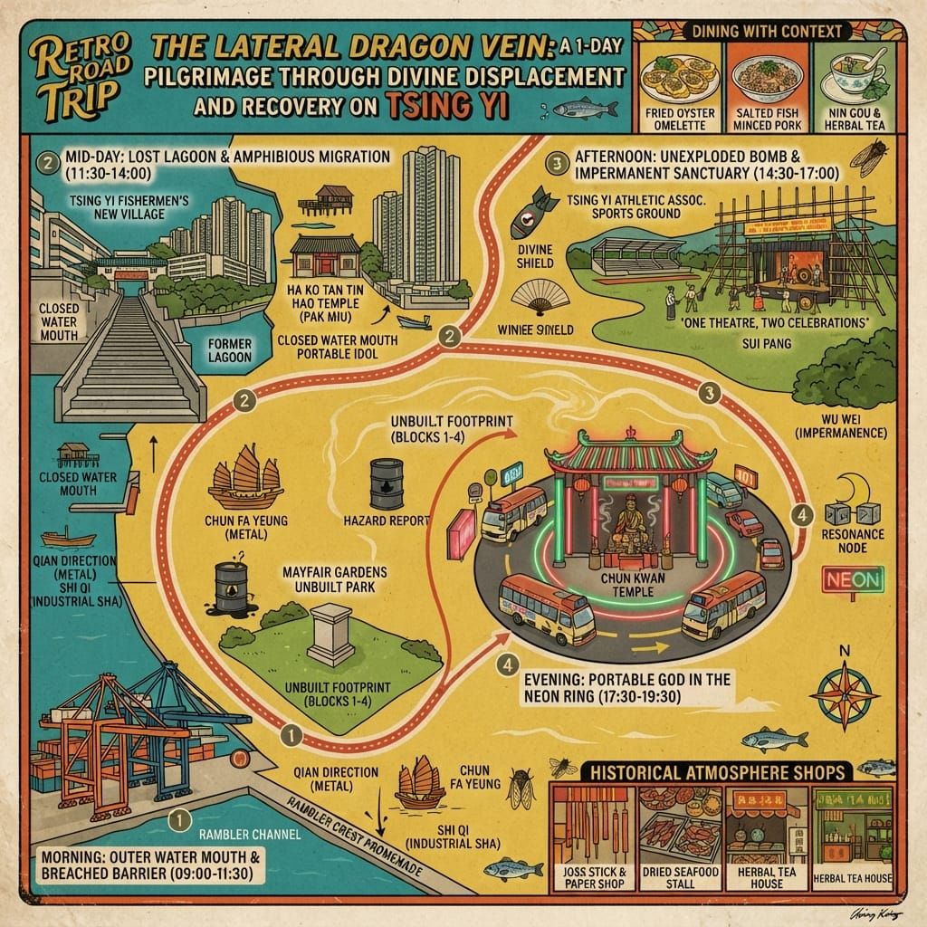
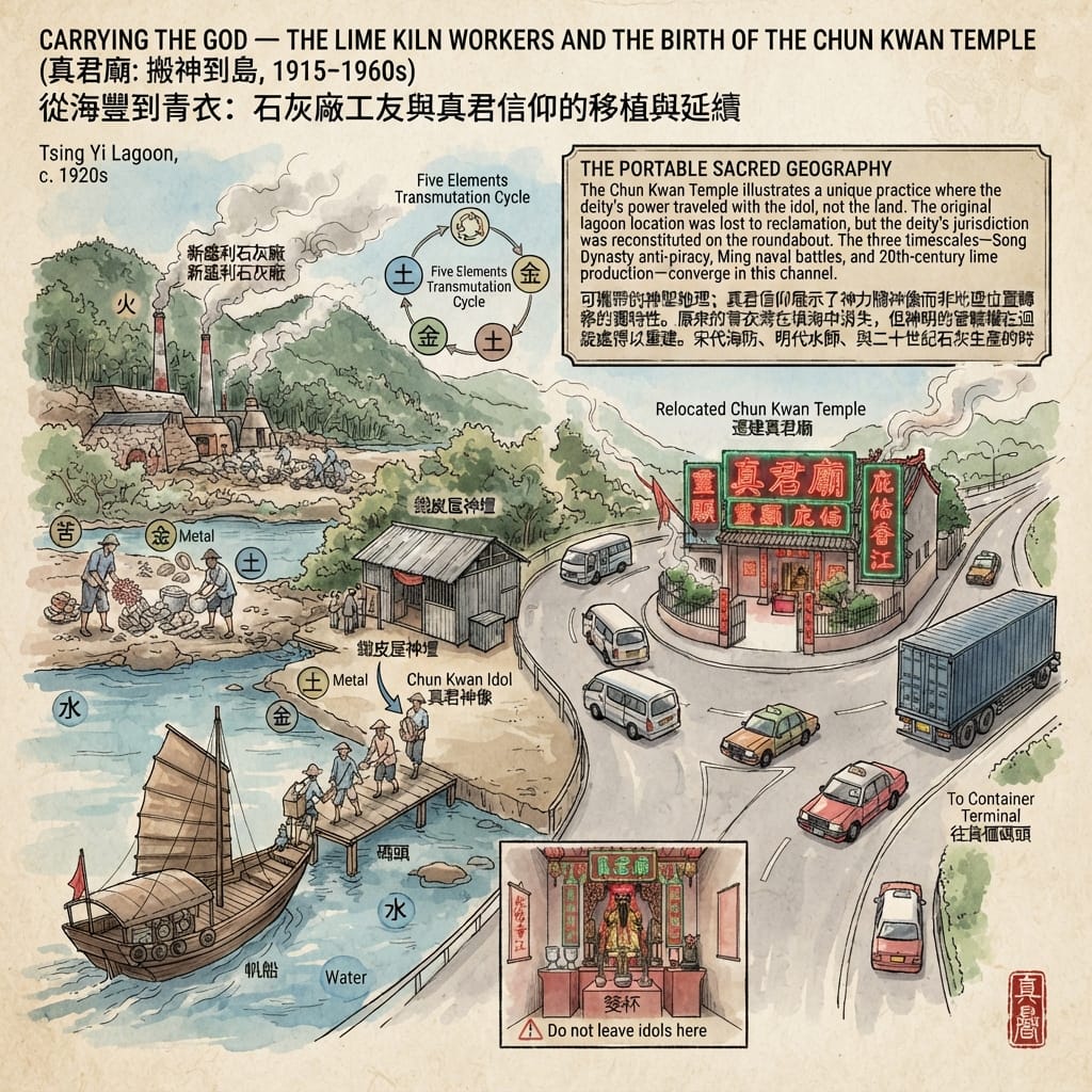
In 1915, a lime-kiln operation called San Shing Lei, run by the Wong family, made its final move — pushed out of one increasingly built-up Kowloon neighbourhood after another until there was nowhere left to go but the sparsely populated shore of Tsing Yi. More than a hundred workers came with it, most of them recruited from Hoi Luk Fung — the twin towns of Hoifung and Lukfung in what's now Shanwei, on the eastern Guangdong coast. Colonial paperwork filed them under "general coolies." What the paperwork didn't capture was that they arrived with something they considered non-negotiable cargo: an idol of Chun Kwan, the True Lord, a deified Song-dynasty official credited with putting an end to piracy along the Guangdong coast. The fact that the idol made it across the water safely was, to the men who carried it, the whole point — proof that the god had agreed to come.
The first shrine was a tin shed on the kiln grounds, doing double duty as a house for the god and a community hall for a workforce a very long way from home — weddings, births, and consultations with the divine all happened under the same tin roof. Through the 1920s to the 1950s, as the lime trade boomed, a company pier turned into public infrastructure and a labour camp turned into a proper settlement. When the industry finally collapsed in the 1950s, undercut by cheaper imports and mechanised competition, the community pooled its savings and rebuilt the temple as something permanent.
The God Who Outlived His Geography
It didn't stay put for long. Reclamation through the 1970s and 80s wiped out Tsing Yi Lagoon entirely, swallowing two small islands along with it and flattening the whole northeastern shoreline. The temple lost its lagoon-front position and was rebuilt again — this time at a traffic roundabout on Fung Shue Wo Road, where it stands today as the only neon-lit temple in Hong Kong, and the only Chun Kwan temple anywhere in the territory.
There's something worth sitting with in that fact. Conventional feng shui theory treats sacred power as bound to a specific piece of geography — a mountain, a watercourse, an orientation — and not something you can simply pack up and take with you. Chun Kwan is the exception that proves how the rule actually works in practice on the ground: his authority travelled with the object, not the site. It's a documented local variant of a wider Cantonese folk practice of "dividing the spirit" to found new branch shrines — except this wasn't a branch. It was the whole deity, relocated wholesale, whose jurisdiction over this specific stretch of island was then built up gradually, through decades of community practice and an accumulating record of favours granted, rather than claimed on arrival.
Those favours are still recounted with real specificity. In 1955, at the opera performance marking the temple's reconstruction, the story goes that storm clouds covered the whole of Hong Kong except Tsing Yi, which stayed in sunshine. In 1961, with a No. 10 typhoon signal hoisted the night before the god's birthday, Chun Kwan is said to have signalled through divination blocks that the festival should go ahead as planned — and the sky cleared by morning. In 1970, during a temple renovation, the idol reportedly insisted, again through the blocks, on being moved out an hour earlier than scheduled — sparing the ceremony from a downpour that arrived at the exact original time. These aren't vague blessings. They're delivered with a level of procedural precision that reads less like folklore and more like a maintenance log.
Black Christmas, a White Temple, and the Bombs That Didn't Go Off
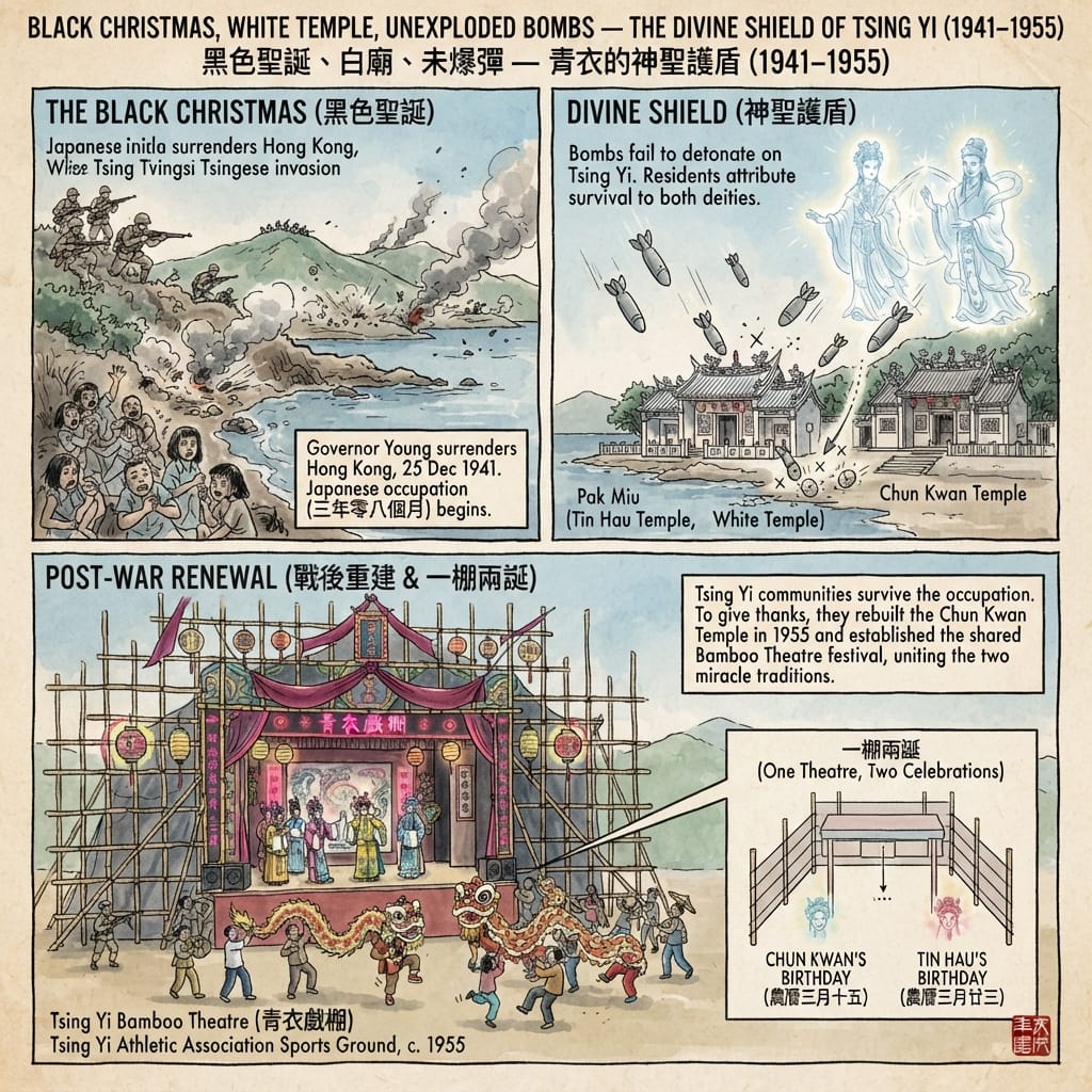
On 8 December 1941, the day after Pearl Harbor, Japanese forces invaded Hong Kong from the north. Eighteen days later, on Christmas Day, the colony surrendered — a date Hong Kong's Chinese population would remember afterward as "Black Christmas." The occupation lasted three years and eight months, a phrase that entered the local vocabulary as shorthand for the outer limit of endurable time.
For the fishing families and lime-kiln workers on Tsing Yi, the occupation meant living next to facilities the Japanese military had every reason to target. According to community accounts — recorded in the island's bamboo-theatre history and repeated in more recent reporting — the bombs that fell on Tsing Yi simply failed to go off. Credit for that survival is split, tellingly, between the island's two protective deities: the fishing community attributes it to Tin Hau, the sea-goddess whose White Temple stood on the lagoon shore; the Hoi Luk Fung community attributes the same outcome to Chun Kwan. Two communities lived through the identical historical event and each narrated its cause through the god they already trusted. No military record has surfaced to confirm or deny any of it. It's entirely possible Tsing Yi simply wasn't a priority target — its lime kilns were never as strategically valuable as the harbour installations closer to the city. That mundane explanation and the community's own explanation have coexisted, unresolved, for eighty years.
The Unexploded Island
Holographic Sensory Cue: the bamboo scaffolding of the festival theatre creaks at a low frequency under harbour wind, underneath the higher clatter of gongs and clappers from the opera stage. Incense smoke from the temporary shrines mixes with the sweetness of fried glutinous rice cake, and underneath both, a faint petroleum note drifts up from the Sai Tso Wan tank farm a kilometre southwest. By night, the theatre's fluorescent tubes turn every face in the crowd the same pale jade colour. Above the rooftops, barely visible against the light-polluted sky, the triple peak locals call Sam Chi Heung — Three Joss Sticks — stands dark and unmoving, like an offering someone forgot to take down.
What ended the war did not end the ritual. Postwar residents staged opera performances to thank Tin Hau for their survival, and by 1961 the two traditions had been formally merged into a single institution — "one theatre, two birthdays" — sharing a bamboo stage each spring for both gods' festivals. The theatre itself, rebuilt from scratch every year and dismantled just as completely afterward, is a working model of a principle that shows up again and again on this island: nothing here has to be permanent to be real. A structure that returns every single year, exactly because it was taken down the year before, can hold a community's claim on a place more securely than concrete ever managed to.
The Last Stilt Houses
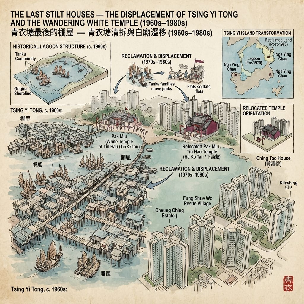
As late as the 1970s, the northeastern corner of Tsing Yi held a landscape you'd struggle to find anywhere else in an urbanising Hong Kong: Tsing Yi Tong, a deep natural lagoon ringed with stilt houses on plank walkways, junks moored wherever there was room. People who saw it firsthand describe it as indistinguishable from Tai O, the Lantau fishing village that still draws visitors today for exactly that reason. The Tanka boat-dwelling families who lived there traced their presence on this water back to the Ming dynasty, and every year on Tin Hau's birthday, fishing families from across the surrounding waters converged here for the festival.
The government's decision to designate Tsing Yi a New Town site in the mid-1970s ended all of it within a decade. Fishing families were moved off their boats into a public housing block named — with an irony nobody seems to have intended to soften — Ching Tao House, "Green Wave House." Land-based villagers were resettled into a scatter of small "resite villages" pressed against the hillsides. The White Temple was pulled from its lagoon-front site and rebuilt at Ha Ko Tan, its second relocation in a single generation. A smaller fishing community on the nearby islet of Nga Ying Chau — people who'd already been displaced once from Tsuen Wan — lost their home a second time when a bridge was built straight through it in the 1990s, and were resettled into a village funded by an American aid donation.
Paving The Sacred Ocean
By the time the New Town was finished, fishing, farming, and pineapple cultivation had all vanished from an island whose population had grown fiftyfold. The temple's second move tells you something about how this community understood its own gods: a shrine facing the water isn't a scenic choice, it's the interface the god's protection is supposed to travel through, and when the lagoon disappeared, moving the temple to keep it facing water — even a different piece of water — mattered more than staying put on the original ground.
Resonance Node: the hillside above Tsing Yi Fishermen's New Village holds a cemetery that almost nobody visits on purpose. Plain concrete markers sit beside elaborate granite ones, all of them looking down a slope toward the flat reclaimed ground where the lagoon used to be, and out toward the harbour beyond it. New graves are still added. The dead here are buried facing the water their families lived on for generations — water that, from where they're buried, you can no longer actually see.
The Report Nobody Was Supposed to Read
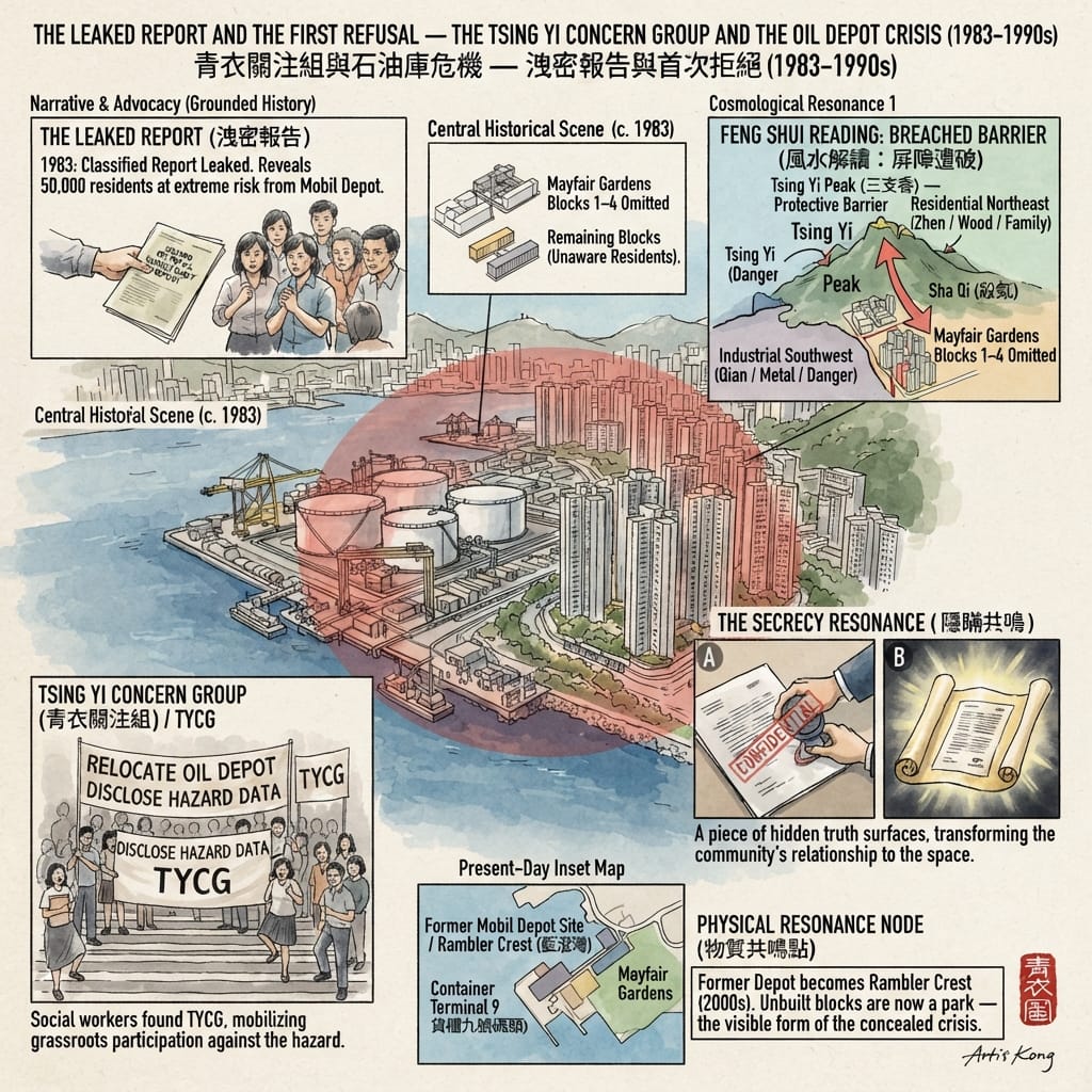
In 1983, a classified document called the Hazard Potential Consultancy Report was leaked to the public. What it revealed was that a Mobil oil storage depot on Tsing Yi's southwestern shore — holding large quantities of flammable petroleum and liquefied gas — sat roughly fifty metres from Mayfair Gardens, a private housing estate that had just been completed. Over fifty thousand people were living inside what planners privately knew was a potential blast radius, information nobody had bothered to tell them before they bought their flats. Four residential blocks closest to the depot had been quietly dropped from the development plan, with no public explanation offered at the time.
The leak triggered the formation of the Tsing Yi Concern Group in 1983, founded by local social workers and remembered today as one of Hong Kong's earliest grassroots environmental campaigns. They demanded the depot's relocation, the cancellation of the estate's final construction phase, and full disclosure of hazard data for every industrial site on the island. They won on the first two counts within a decade — the depot moved out as Container Terminal 9 took over the southwestern shore, and its old footprint became the Rambler Crest development that stands there now. A second fight, over a dioxin-emitting incinerator commissioned in 2004, produced no such resolution; it still operates today, its long-term health effects an open question the community has never stopped asking.
The Secret Blast Zone Park
The island's industrial zoning, laid out long before anyone thought to ask a feng shui geomancer's opinion, happens to follow the old logic anyway: heavy industry concentrated in the southwest, family housing in the northeast, with Tsing Yi Peak sitting between the two like a wall built to keep noxious influence from crossing over. The 1983 crisis happened exactly where that wall had been quietly breached — a housing estate built on reclaimed buffer land, directly beside the thing the buffer was supposed to hold back. Whether or not you find that framework persuasive, the pattern underneath it is hard to argue with: information an authority chose not to share, followed by a community that built its own machinery — first divine, later civic — to manage the gap between what it was told and what it was actually living next to.
What This Island Has Actually Been Doing All Along
The tidy version of Tsing Yi's history goes: fishing village, then industrial zone, then residential new town, then transport hub. It's not wrong, exactly, but it treats each phase as erasing the one before it, and that's not what actually happened here. Look closer and there's a different, steadier pattern running underneath all four phases: every time this island absorbed a shock — a naval battle, a wave of migrant labour, an occupying army, a bulldozed lagoon, a hidden safety report — the response was the same. A community reached for whatever protection it already trusted, credited its survival to that protection specifically, and then rebuilt that protection's physical home to fit the changed ground beneath it, without ever treating the function itself as interrupted.
Nobody planned that as a system. It just kept happening, generation after generation, whether the threat was a pirate fleet or a leaked government memo. The island's coastline has been redrawn so many times that almost nothing from the original shore still exists in its natural state. What has survived — the neon temple at the roundabout, the bamboo theatre rebuilt every spring, the graves that still face water they can no longer see — isn't a monument. It's a habit. And habits, it turns out, are considerably harder to reclaim than land.
There's a case to be made that this is the real inheritance worth paying attention to, on Tsing Yi and everywhere else that keeps getting rebuilt out from under the people who live there: memory doesn't actually need a fixed address to survive. It needs somewhere to keep showing up. If that kind of history is the sort of thing you want more of in your inbox, this is the place to sign up.
Getting to the Site
Getting there: Take the MTR Tung Chung Line or Airport Express to Tsing Yi Station. From there, it's a short walk or a light rail connection to the Fung Shue Wo Road roundabout, where the neon-lit Chun Kwan Temple sits in plain sight of passing traffic. For the Fishermen's New Village, a route minibus from the station up the hillside is the easiest option; the relocated Tin Hau Temple at Ha Ko Tan is reachable on foot from the Cheung Hang or Cheung On estates. To find the old Chun Fa Lok shoreline, walk the waterfront promenade from Tsing Yi Pier past the Sai Tso Wan tank farm perimeter.
Where to stay: A cluster of business hotels near Tsing Yi Station and the Maritime Square mall makes a reasonable base for splitting the island into an eastern and western day of walking.
Guided visits: The best time to experience the island's dual religious calendar directly is during the "one theatre, two birthdays" festival each spring at the Tsing Yi Athletic Association Sports Ground. Outside festival season, local heritage walking-tour operators run routes that string together the temples and the vanished fishing settlements for anyone who wants the fuller version of this story on foot.
💡 Tsing Yi Geospatial Unveiled: Folklore, Feng Shui & Historical Dossier Q&A
Q1: Is Rambler Channel and Chun Fa Lok in Tsing Yi haunted? What is the historical truth behind the urban legends?
Historical & Geospatial Analysis:
Urban legends associate Tsing Yi's Chun Fa Lok and the Rambler Channel with unexplained maritime accidents and spectral lights. Historical records reveal that during the Ming Dynasty, imperial naval forces engaged in an unrecorded battle here against pirates to secure "Chun Fa Yeung." In Feng Shui hydrology, this area marks Victoria Harbour's "outer water mouth"—a vital threshold where protective energy meets open waters. The location was renamed Tsing Yi after local parrotfish. The alleged supernatural occurrences actually stem from historical memories of naval warfare and complex hydraulic currents, reframing a ghost story into a rich history of maritime defense and geospatial symbolism.
Q2: Why does Tsing Yi's Zhen Jun Temple feature neon lights, and was it built to suppress evil spirits?
Historical & Geospatial Analysis:
Popular rumors suggest Zhen Jun Temple's traffic roundabout position and iconic neon lights were designed as a Feng Shui array to suppress dark spirits. In reality, Hailufeng lime kiln workers brought the deity Zhen Jun (Song Dynasty official Wu Ganghou) to Tsing Yi in 1915. Extensive land reclamation in the 1970s and 1980s erased Tsing Yi Bay and Nga Ying Chau, forcing the temple to relocate twice before settling on Fung Fai Road. The neon lights reflect modern urban integration rather than exorcism, demonstrating how Cantonese maritime deity worship adaptively migrates alongside worker communities across changing coastal landscapes.
Q3: Was Mayking Garden on Sai Shan Road built over a WWII mass grave, causing hauntings?
Historical & Geospatial Analysis:
Local folklore claims Mayking Garden on Sai Shan Road was constructed over WWII mass execution grounds, leading to tales of haunted elevators and cold spots. Geographical records confirm Mayking Garden was built in 1981 as Tsing Yi's first private residential estate. Sai Shan Road originally ran along the isolated foothill of Tsing Yi Peak adjacent to quarries and scattered rural graves, all of which were systematically relocated following standard government protocols during new town development. The eerie perception stems from early suburban isolation and valley topography rather than haunting, reflecting psychological responses to rapid urban transformation.
Reference and Further reading
First layer – Main sources of literature and institutions:
- 新安縣志 (Xin'an County Gazetteer) — primary administrative record for the region; Ming and Qing editions held in the National Palace Museum (Taipei) and the First Historical Archives of China (Beijing). The specific battle record should be verifiable here. 建議進一步查證原始檔案.
- Ming dynasty 廣東通志 (Guangdong Provincial Gazetteer) — records of Pearl River Delta naval operations.
- Hong Kong Memory (香港記憶) digital archive, Hong Kong Public Libraries: prewar maps showing the original Chun Kwan shrine location on the Tsing Yi lagoon shore.
- 1950s Chinese-language newspaper records cited in Kilpatrick (2026) — specific titles and dates not identified in available material. 建議進一步查證原始檔案.
- Hong Kong Government Records Service (歷史檔案館): Colonial Secretariat records of the Japanese occupation period may contain incident reports for Tsing Yi; these have not been examined.
- Hong Kong Housing Authority records of the Tsing Yi New Town development planning, 1970s–1980s; resite village establishment records. Held at the Planning Department and HKHA archives.
- 青衣鄉事委員會 (Tsing Yi Rural Committee) administrative records — would document the resite village arrangements and negotiations.
- The Hazard Potential Consultancy Report (c. 1983): current location and public availability unknown; classified at time of leak. 建議進一步查證原始檔案.
- Hong Kong District Board / District Council records of TYCG submissions and government responses, 1983–1995.
- Town Planning Board records of Mayfair Gardens / oil depot proximity decisions.
The second layer – secondary academic materials:
- Hayes, James (1993). Tsuen Wan: Growth of a 'New Town' and its People. Oxford University Press. [Regional context for Ming-Qing period Tsing Yi/Tsuen Wan administrative history]
- Murray, Dian H. (1987). Pirates of the South China Coast, 1790–1810. Stanford University Press. [For regional piracy framework, though focused on later period]
- Kilpatrick, Ryan (2026, January 29). "Pirates, Magic and Neon: Tsing Yi's Chun Kwan Temple." Zolima City Magazine. [Ethnographic journalism; primary source for the Wong family testimony and lime-kiln history]
- Wikipedia, "Chun Kwan Temple" and "Chun Kwan."
- Endacott, G.B. (1978). Hong Kong Eclipse. Oxford University Press. [Standard reference for the Japanese occupation period, does not focus on Tsing Yi specifically]
- Wikipedia, "Tsing Yi Bamboo Theatre" (citing community oral records of post-war origins).
- Hayes, James (1993). Tsuen Wan: Growth of a 'New Town' and its People. Oxford University Press. [Critical regional reference]
- Wikipedia, "Tsing Yi," "Tsing Yi Fishermen Village and St. Paul's Village," "Nga Ying Chau."
- Crothall, Geoffrey. "Exploring My Island Home." (Blog; primary observation of hillside graves and Nga Ying Chau displacement)
- Lee, Yok-shiu F.; So, Alvin Y. (1999). Asia's Environmental Movements: Comparative Perspectives. M.E. Sharpe. pp. 61–62. [Documents TYCG formation and oil depot mobilization]
- Sing, Ming (2004). Hong Kong's Tortuous Democratization: A Comparative Analysis. Psychology Press. p. 234. [Situates TYCG within Hong Kong's democratization history]
- South China Morning Post: "Tsing Yi residents hit relocation timing." 1 January 1993. [Documents ongoing community concerns about depot relocation timeline]
- Wikipedia, "Tsing Yi Concern Group."
Third layer – Supplementary information:
- Wikipedia, "Tsing Yi" (en.wikipedia.org, citing Ming gazetteers): the Chun Fa Yeung naval battle reference.
- Wong Tai-yan (descendant of the Wong family / San Shing Lei kiln), oral testimony, cited in Kilpatrick (2026). Treated as documented community oral history.
- Kilpatrick, Ryan (2026). "Pirates, Magic and Neon: Tsing Yi's Chun Kwan Temple." Zolima City Magazine. [Documents community oral tradition of the unexploded bombs, attributed to Chun Kwan]
- Tsing Yi Bamboo Theatre Wikipedia: documents the post-war origin of bamboo theatre as a thanksgiving act to Tin Hau.
- University of Hong Kong Digital Repository: "Fishermen's Village, Tsing Yi 青衣漁民新村" (1966 photographic record).
- Hong Kong Inmedia: 「尋找青衣牙鷹洲油庫原址」[Searching for the Original Site of the Tsing Yi Nga Ying Chau Oil Depot]. (Archived 2022.)
Historical gap:
- The specific Ming document citing the Chun Fa Yeung naval battle has not been located in digitized form. The battle appears in local-history summaries but its primary source — likely a naval record in the 廣東通志 or a Xin'an County entry — requires direct archival access. The nature and scale of the engagement, the names of commanders, and the date are all unverified in available secondary literature.
- The administrative records of the San Shing Lei kiln — employment rolls, pierage permits, colonial business registration — have not been located in available sources. These would be held at the Public Records Office (歷史檔案館) of the Government Records Service, Hong Kong. They would document the precise dates of workforce arrival, the number of Hoi Luk Fung workers, and potentially the mode of transportation of the Chun Kwan idol.
- No official military or colonial record has been located that documents unexploded ordnance incidents specific to Tsing Yi during 1941–1945. The miracle accounts exist entirely in community oral tradition and postwar folk records. It is possible that Tsing Yi was simply not a primary bombing target (the island's lime kilns were less strategically significant than harbour installations or military barracks); this mundane explanation and the community's divine-protection explanation coexist without resolution in the available record. 建議進一步查證原始檔案 — specifically the Japanese military occupation records held at the Japan Center for Asian Historical Records (JACAR) in Tokyo.
- The lived experience of the Tanka fishing families during the displacement process is not documented in available secondary literature. Oral history interviews with first-generation residents of the resite villages and Cheung Ching Estate would constitute an irreplaceable primary record that is rapidly becoming inaccessible as the community ages. 建議進行口述歷史訪談.
- The identity of the individual(s) who leaked the Hazard Potential Consultancy Report has never been established in public record. The report itself appears not to have been formally declassified or deposited in the Government Records Service. An investigation of the colonial government's internal risk-assessment procedures for industrial-residential co-location in the New Towns period would significantly advance understanding of how the 1983 crisis was structurally enabled.
 Lawrence
 Lawrence
© Historical Travel Stories — Unraveling Strange Tales Across Dimensions and Time