Linkou Plateau: The Threshold That Keeps Refusing the Blueprint
On a windswept red-clay plateau outside Taipei, five buried histories share one pattern: every regime that tried to master this land — colonial, military, national — was eventually answered by the same fog, the same fault line, the same red soil.
On a windswept red-clay plateau outside Taipei, five buried histories share one pattern: every regime that tried to master this land — colonial, military, national — was eventually answered by the same fog, the same fault line, the same red soil. This is a walk across a threshold that has never fully closed.
 Lawrence
The Weight of an Unfinished Place
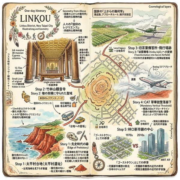
Some places matter not for what got built on them, but for what refused to stay built. Linkou is one of those places — a low red-clay tableland wedged between the Taipei Basin and the Taoyuan plain, unremarkable at highway speed, until you learn what it has quietly absorbed. A skull ten thousand years old surfaced from its coastline. A goddess was hidden in its villages to survive an empire's attempt to erase her. A tea plantation became a runway built for aircraft that were never meant to come home. A passenger jet went down in the fog exactly where that runway once was. And a city built for a quarter of a million people waited three decades for its first real neighborhood to arrive. None of these stories know about each other in most tellings. Standing on this plateau, you start to suspect they were never separate stories at all.
Listen to the historical stories told in detail (For subscribers only)
The Grounded History: Five Things This Ground Remembers
The Skull Under the Red Clay
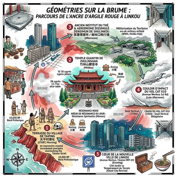
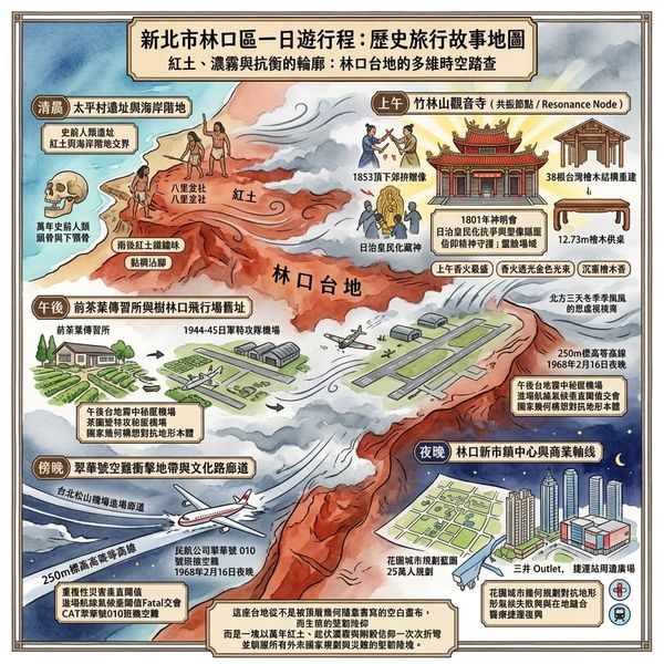
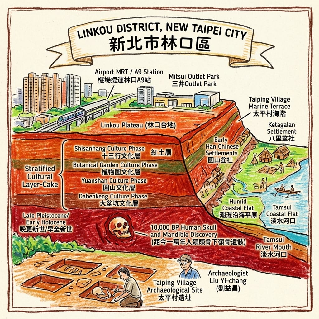
Long before anyone wrote this land's name down, someone was buried on its coastal terrace. In 1997, archaeologists surveying the shoreline between Linkou and neighboring Bali uncovered the Taiping Village site — a single location where, almost improbably, nearly every layer of northern Taiwan's prehistoric record sits stacked on top of the next: Dabenkeng, Yuanshan, Botanical Garden, Shisanhang, one cultural horizon pressed against another like sediment.
The Ten-Thousand-Year Layer Cake
Archaeologist Liu Yi-chang confirmed the recovery of a human skull and jawbone from this terrace dated to roughly ten thousand years before present — among the most complete prehistoric human remains ever found in Taiwan. By the time written records begin, in Dutch trading logs of 1642 and a Chinese travelogue from 1697, this coastline belonged to the Ketagalan-affiliated Bali-fen community. No name from that ten-thousand-year span survives. What survives is the terrace itself, and the fact that whoever lived here first understood, correctly, that the edge of this plateau was worth staying for.
The Goddess Who Was Hidden to Survive
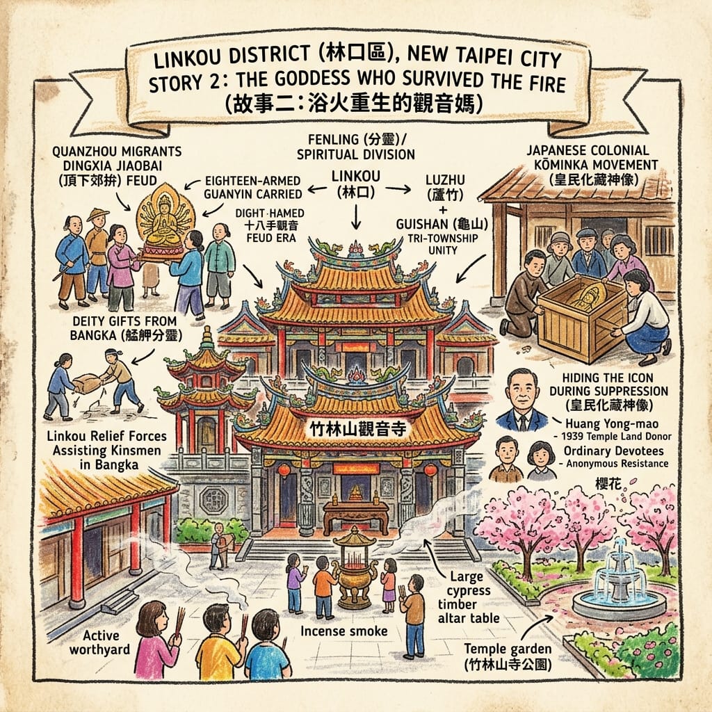
In 1801, Hoklo settlers established a rotating devotional society around an eighteen-armed Guanyin image carried over from a temple in Anhai, Fujian. For half a century she had worshippers but no fixed home, passed between eighteen village wards in turn. Everything changed with one of the deadliest feuds in Taipei's history — the Dingxia Jiaobai clashes of 1853–1859, in which rival Quanzhou factions tore the Bangka district apart. Local accounts hold that Linkou families answered a call for reinforcements from the eventual winners, helping drive the losing faction out to what would become Dadaocheng — a displacement that reshaped Taipei's commercial geography for a century. In gratitude, the victors gifted their allies a Guanyin statue from Bangka's own Longshan Temple, deepening the cult that would eventually settle in Linkou. But the harder test came under Japanese rule. In the assimilation campaigns of the late 1930s, colonial authorities moved to stamp out Taiwanese folk religion outright, reportedly attempting to destroy this very image.
The Goddess The Empire Couldn T Burn
Villagers hid her, quietly passing her between households, until the authorities relented and permitted a temple — built, in 1939, in a Japanese-approved style, and named Zhulinshan by splicing together the names of the three townships that worshipped her: Luzhu, Linkou, Guishan. She has since been rebuilt in full traditional form, using thirty-eight ancient cypress beams, more than any other temple in Taiwan. A goddess who survived a massacre and an empire, by being hidden in plain sight.
The Tea Field That Became a Runway With No Return Flight
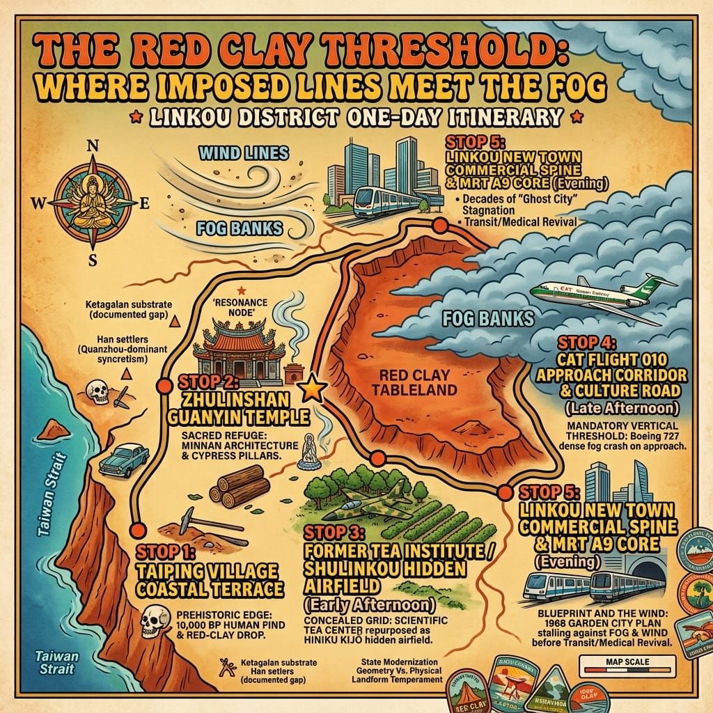
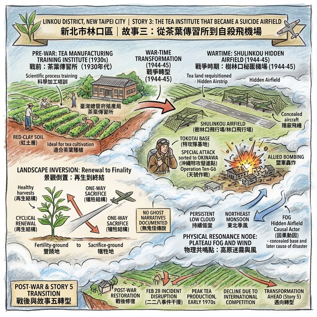
By the late colonial period, Japanese administrators had identified Linkou's acidic red soil as ideal tea country and built a training institute here that made the plateau a genuine center of technical expertise, producing skilled tea farmers for the whole island. Then the Pacific War reached its final, desperate phase. Large sections of that same tea land were requisitioned and paved into Shulinkou Airfield, one of a documented network of "hidden airfields" built across Taiwan in 1944–45 specifically to shelter aircraft from Allied reconnaissance — and, in the war's last spring, to stage kamikaze sorties as part of Operation Ten-Gō, sending pilots north toward Okinawa on flights with no return leg.
Wwii S Secret Tea Garden Airbase
A landscape organized for generations around renewal — tea bushes harvested again and again across decades — was repurposed, almost overnight, for a program organized entirely around finality. The institute reopened after the war and tea production even peaked in the early 1970s, but the ground beneath it had already been asked to hold two irreconcilable meanings at once.
The Night Flight 010 Met the Fog
On the evening of February 16, 1968, a Civil Air Transport Boeing 727 inbound from Hong Kong to Taipei's Songshan Airport had to clear the 250-meter Linkou plateau before beginning its final descent — a mandatory step in the approach that every pilot flying that route knew by heart. That night, an off-duty pilot riding along had been handed the controls, and he did not know the procedure as intimately as he should have. By the time he realized how close the ground lights were, and the captain retook the controls, there was no more sky left to work with. The aircraft came down on the grounds of the former Tea Institute — the same ground once cleared for kamikaze runways — killing twenty-one people in what was then Taiwan's worst civil aviation disaster. Thirty years later, to the calendar day, China Airlines Flight 676 crashed on approach to the same region's other airport, killing 196. No mechanical or procedural link connects the two crashes; the coincidence is calendrical, not causal. What is not coincidental is the geography: this plateau sits directly across a mandatory approach corridor, wrapped for a good part of the year in the same northeast-monsoon fog that once hid an airfield from enemy reconnaissance. It is not an omen. It is measurable terrain doing, twice, exactly what measurable terrain does.
Holographic Sensory Cue: Picture that February night — a cold, wet northeast wind dragging a wall of pale fog up over the plateau's exposed edge, visibility collapsing from clear to near-zero within minutes; the low engine drone folding into the hiss of wind over bare red clay; a flicker of instrument light against a cockpit window where the ground has just appeared far too close; the mineral smell of wet laterite mixing, on the ground, with the acrid smoke of scattered wreckage. Nothing supernatural moves through this scene. It is weather, elevation, and a few seconds of human error, converging exactly where they had converged once before.
The City Built for 250,000 That Waited Thirty Years for Its First Residents
Starting in 1968, planners modeled Taiwan's very first purpose-built new town on the English garden city — low-density housing, a defined commercial core, room to breathe, all laid across this same plateau to relieve overcrowding in the Taipei Basin. By 1978 it had been folded into the national government's flagship infrastructure program. On paper it would house a quarter of a million people. In practice, the plateau's relentless monsoon wind and fog, combined with a land-readjustment system that let owners sit on vacant lots indefinitely without penalty, meant the town filled to barely a third of its target population, with whole blocks standing empty for a generation. Locals took to calling it a ghost city. The turnaround came in pieces — a major teaching hospital in 1976, a freeway interchange, an airport rail line, a technology park next door — until, decades late, the blueprint finally caught up with the ground it had been drawn on.
The High-Dimensional Lens: Reading Linkou on Its Own Terms
No documented feng shui tradition or named dragon-vein system attaches specifically to this plateau. Forcing one onto it here would be exactly the kind of borrowed mysticism that flattens a real place into stock travel-blog atmosphere — so this section uses only the two frameworks the record actually supports.
The first belongs to Han Chinese folk religion itself, and its own concept of fenling — the "division of spirit," by which an image can carry its origin temple's accumulated efficacy into new territory without diminishing the source. Zhulinshan's Guanyin is a rare, legible case of this logic playing out twice: first when she was gifted across a feud line as an act of gratitude, and again when she was hidden, household to household, because within this belief system an image is not a symbol but a vessel that has spent generations accumulating a living relationship with its community. To destroy her was understood, in that vocabulary, as extinguishing a relationship, not removing an object. Concealing her was custodianship. And the temple's very name — three township names spliced into one — shows something unusual even within that tradition: a parish boundary redrawn by devotion and shared hardship, rather than devotion simply following an existing boundary, as is far more typical of Chinese temple geography.
The second framework is written in stone, not scripture: the Xinzhuang and Shanjiao faults that lift this plateau 250 meters above the surrounding lowland, carving it into a genuine, mandatory threshold in the region's geography. The prehistoric settlers chose its terrace edge. The wartime military exploited its elevation and fog for concealment. The 1968 disaster happened exactly where pilots were required to clear that same elevation. The new town's planners walked straight into the same wind and fog without adequate preparation. None of this is metaphysics. It is a documented, repeatable geographic fact — but when the same physical threshold resurfaces across four unrelated centuries of human ambition, each time extracting the same toll, it stops being coincidence and starts functioning as this place's one genuinely native cosmology: a threshold built from fault line and fog, and every plan that tries to cross it pays something to get through.
Behind Zhulinshan temple, past where the cherry blossom garden thins out, a scatter of old tea shrubs still clings to a slope that almost no visitor finds. The temple's incense and crowd noise fade out within a few dozen steps. What's left is wind moving across red clay and half-wild tea plants that were once tended by hand, then requisitioned for a runway, then witness to a plane crash — three unrelated histories stacked on the same few square meters, with not a single marker to say so. Of everywhere on this plateau, this is where the distance between past and present feels thinnest.
Conclusion: What This Ground Is Actually Teaching Us
Linkou doesn't offer proof of anything supernatural. What it offers is quieter and, in its way, more useful: a demonstration, repeated across ten thousand years, that no blueprint — colonial, military, or national — gets to have the last word on a piece of land. Prehistoric settlers, feuding clans, an occupying military, and a modernizing state each arrived here convinced their plan was the one that would finally stick. Each time, the plateau answered on its own terms — with fog, with wind, with red clay that outlasts every economy built to exploit it — and each time, the people actually living here simply began again: hiding a goddess, replanting a tea field, filling in a half-empty new town one hospital and one train line at a time.
In an age increasingly confident that a well-optimized plan can out-think a place, Linkou is a useful correction. The thing that actually endures here was never the blueprint. It was the patience of the people who kept starting over. That, more than any energy line or sacred axis, may be the closest thing to a durable resource this species has — and it costs nothing to remember it.
If that kind of forgotten history is worth more of your attention, subscribe below, and we'll send the next buried story straight to your inbox.
Accessing the Physical Node
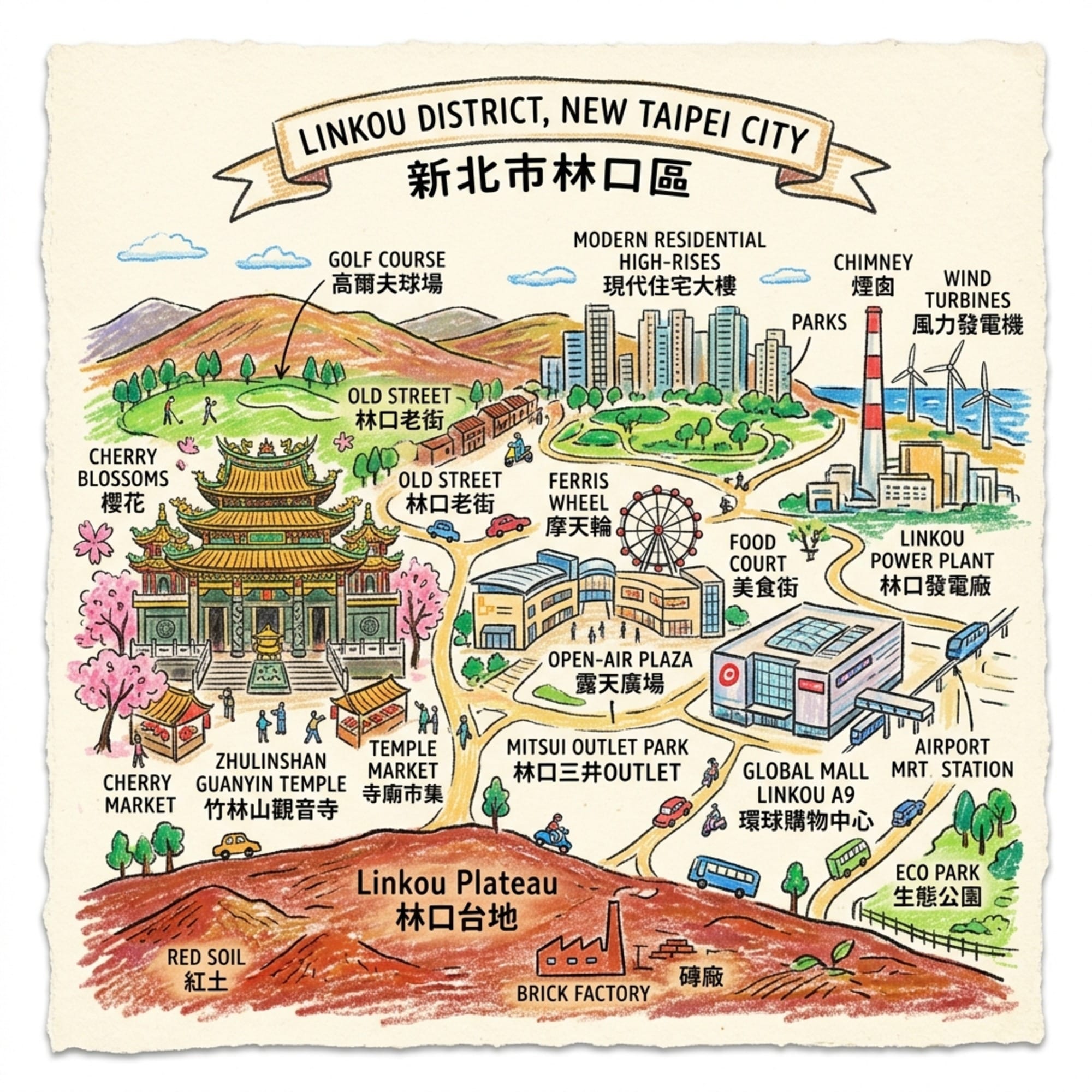
Getting there: The Taoyuan Airport MRT line runs directly through the plateau, with Chang Gung Memorial Hospital Station (A8) and Linkou Station (A9) both within easy reach of the sites described above. Drivers can exit National Highway 1 at the Linkou interchange.
Where to anchor overnight: The hospital district around Chang Gung Memorial has the area's best concentration of business hotels, a convenient base for a two-stop visit; travelers who'd rather stay closer to the shops can find comparable options near Mitsui Outlet Park Linkou.
A suggested route: Start at Zhulinshan Guanyin Temple, ideally in the late afternoon when the incense crowds have thinned. Walk the older Linkou street grid nearby to feel the settlement pattern that predates the New Town. Then follow Wenhua Road's first three sections, where 1980s garden-city townhouses give way, block by block, to glass towers — a visible seam between a failed first draft and its overdue sequel. With extra time, head to the coastal terrace where the Taiping Village site was found, and stand where the plateau finally drops to meet the sea. A local heritage guide, if you can find one, will know details this piece had no room for — ask them for a temporal walk, and let them fill in what the ground remembers that we couldn't.
🔍 📌 Linkou Urban Legends & Geospatial History FAQ
Q1: Why is the Linkou Lightning Building rumored to be haunted, and what is its real history?
A:
The Linkou Lightning Building, long featured in Taiwanese urban legends, was rumored to be haunted due to its jagged, zigzag facade and decades of dereliction. Folk folklore suggested its odd angles created severe feng shui bad omens. Historical records confirm the building was initiated in the 1990s as an avant-garde modernist architectural experiment. Its long-term abandonment stemmed entirely from economic distress during the 1997 Asian Financial Crisis and subsequent multi-party property ownership litigation, rather than any paranormal activity. The structure was officially demolished and cleared in 2020.
Q2: Is Linkou Buffalo Canyon a natural geological wonder or linked to local urban legends?
A:
Linkou Buffalo Canyon, popularly known as Taiwan's Grand Canyon, sparked local folklore about mysterious earth anomalies and cursed badlands. Geospatial historical analysis reveals the dramatic yellow cliff terrain is neither an ancient natural formation nor a spiritual site. Instead, it represents severe ecological scarring caused by illegal sand and gravel mining during the 1990s Taipei construction boom. Farmers subsequently brought grazing cattle to the exposed mudstone quarry, turning an environmental disaster into a famous human-altered pastoral landscape.
Q3: Does the persistent fog in Linkou stem from bad feng shui or negative spiritual energy?
A:
Historically known as "Shulinkou," the area's persistent mist was often dramatized in local folklore as a gathering of cold, negative "yin" energy. Meteorological geography explains that the 250-meter elevation of the Linkou Plateau directly captures warm, moist air masses coming off the Taiwan Strait, producing natural advection fog in spring and radiation fog in winter. Extensive high-rise urbanization over recent decades has altered the plateau's microclimate, substantially decreasing fog frequency.
Reference and Further reading
First layer – Main sources of literature and institutions:
- New Taipei City / Linkou District Office historical gazetteer (新北市林口區公所〈歷史沿革〉);
- Ministry of Culture Bureau of Cultural Heritage national archaeological-site records for comparable Dabenkeng-culture sites.
- Ministry of the Interior's Taiwan Religious Culture Map / 臺灣宗教百景 (moi.gov.tw) entries on Zhulinshan Guanyin Temple;
- New Taipei City tourism bureau site listing.
- National Archives Administration (國家發展委員會檔案管理局) feature "林口的蛻變:從茶園、磚廠到新市鎮崛起," drawing on Ministry of National Defense History and Translation Bureau (國防部史政編譯局) wartime airfield maps (檔號 0034/913/4010.2).
- Contemporary Taiwanese newspaper photo archives (United Daily News / 聯合報 udn.com retrospective, "1968年翠華號客機墜毀林口");
- Wikipedia entry citing period investigation findings on CAT Flight 010.
- New Taipei City Government Land Administration Bureau (新北市政府地政局) official land-readjustment project records for Linkou New Town Phase III;
- National Archives Administration feature cited in Story 3.
The second layer – secondary academic materials:
- Liu Yi-chang's published survey findings on the Taiping Village site (太平村遺址);
- General Dabenkeng-culture scholarship (大坌坑文化研究).
- Chinese-language Wikipedia entry on 竹林山觀音寺, cross-referenced against temple-published history.
- Academia Sinica GIS Research Center feature on Japanese WWII airfield construction in Taiwan ("探析地圖上二戰末期日軍飛行場在臺灣建置之軌跡"), which explicitly classifies Shulinkou (樹林口) among the northern-concentration "hidden airfields" (秘匿機場) used for tokkōtai staging;
- Supplementary scholarship by Hung Chih-wen (洪致文) on Taiwan's WWII-era airfields.
- Aviation-history retrospectives on CAT's operational history and its post-crash license non-renewal.
- Housing-industry trade press analysis (住展雜誌 "住展區域分析") on the New Town's planning history and stalled execution;
- Chang Gung Memorial Hospital institutional history.
Third layer – Supplementary information:
- Yu Yonghe, Bihai Jiyou (裨海紀遊, 1697) — a primary-adjacent travel account, treated as valuable but period-bound testimony, not modern ethnography.
- Chung Shih Kuang / China Times feature ("竹林山觀音寺 經歷三段傳奇歷史") narrating the Dingxia Jiaobai gift-of-the-idol story and the Kōminka concealment story — this is popular-press oral-history-adjacent material, not an academic citation, and is flagged accordingly: 建議進一步查證原始檔案,確認頂下郊拚贈神像之口述傳統與皇民化時期藏神像事件之原始文獻依據.
- None credibly located for oral/local mythological material specific to this site's wartime function — flagged as a genuine gap.
- Local online forum discussion (Mobile01) documenting present-day resident debate over the site's reputational/feng shui status — treated strictly as evidence of contemporary popular memory-geography, not as verified historical fact.
- Local blog/forum retrospectives (e.g., "林口葡萄藤" blog, "莫讓昔日夢魘再現") documenting the "ghost city" reputation as lived local memory rather than verified statistic.
Historical gap:
- No surviving Ketagalan-authored or Ketagalan-narrated account of the site's meaning exists. 建議進一步查證原始檔案 — further verification against Academia Sinica ethnohistorical archives on Basay/Ketagalan groups is recommended before any claim about "what the site meant" to its makers is advanced.
- The precise identity of who hid the icon, and exactly how, is not preserved in any source located; this is a genuine gap in the record, not a detail this dossier will invent.
- Squadron identities, casualty figures, and exact sortie counts specific to Shulinkou (as opposed to the broader northern hidden-airfield network) require further archival verification: 建議進一步查證原始檔案(國防部史政編譯局檔案、美軍偵照紀錄)以確認樹林口飛行場之確切駐防與出擊紀錄.
- No official memorial or heritage marker for the crash site was located in available sources; whether one exists and is simply undocumented online warrants further on-the-ground verification (建議實地查證是否設有罹難者紀念設施).
- Precise population figures across the New Town's stalled decades vary by source and year of measurement; a definitive time series was not consolidated here. 建議進一步查證新北市政府歷年人口統計原始資料 for any publication-grade population claims.
 Lawrence
 Lawrence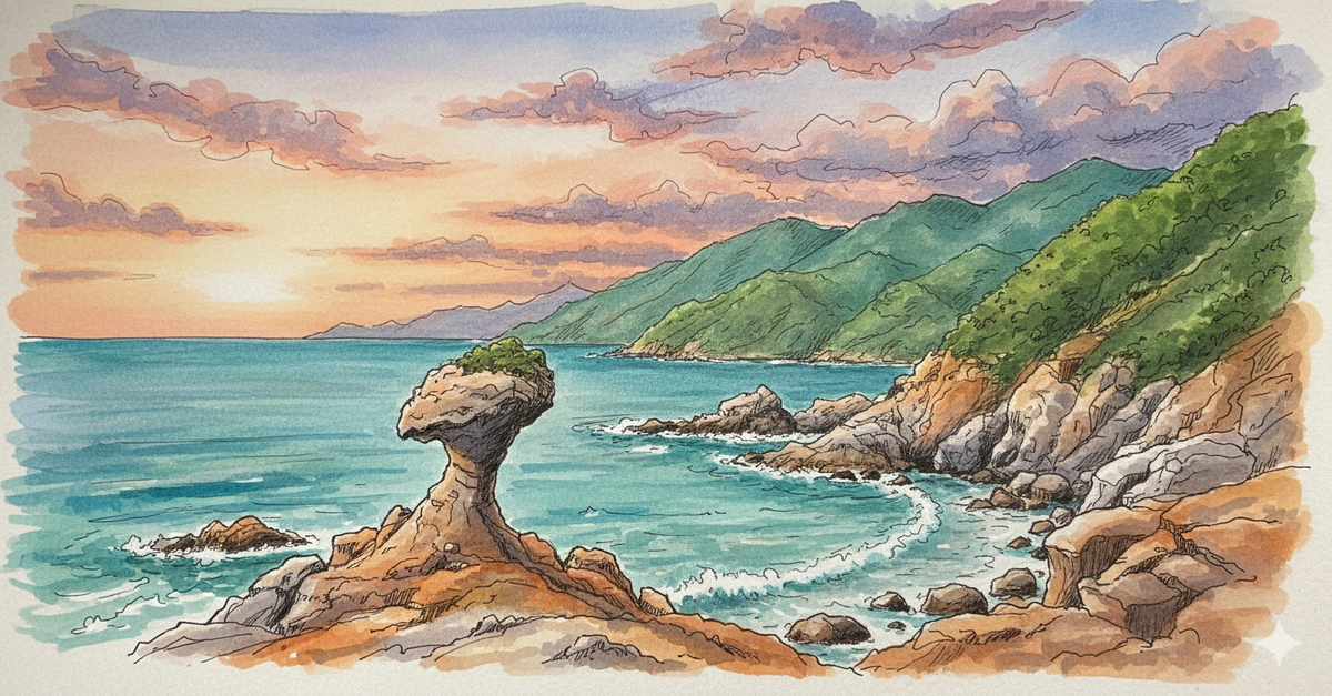
 Lawrence
 Lawrence
© Historical Travel Stories | Unraveling Strange Tales Across Dimensions and Time