(ENG) Wong Chuk Hang, Hong Kong: The Valley That Named a City — Then Had Its Name Taken Away
While known today for industrial lofts and art galleries, Wong Chuk Hang holds 3,000 years of memory. This walking guide takes you past hidden riverbeds to uncover prehistoric rock carvings and the exact spot where the name "Hong Kong" was born.

This is a historical travel story and walking guide to Wong Chuk Hang, a dynamic valley on the southern side of Hong Kong Island. Beyond its modern image as an industrial and contemporary art hub, this slow walk explores Nam Fung Road, old walled villages, and ancient riverbeds to reveal prehistoric rock carvings and the true birthplace of the name "Hong Kong." Readers will discover a 3,000-year historical trajectory, shifting their perspective from a concrete neighborhood to a timeless crossroads of indigenous heritage and early maritime trade.
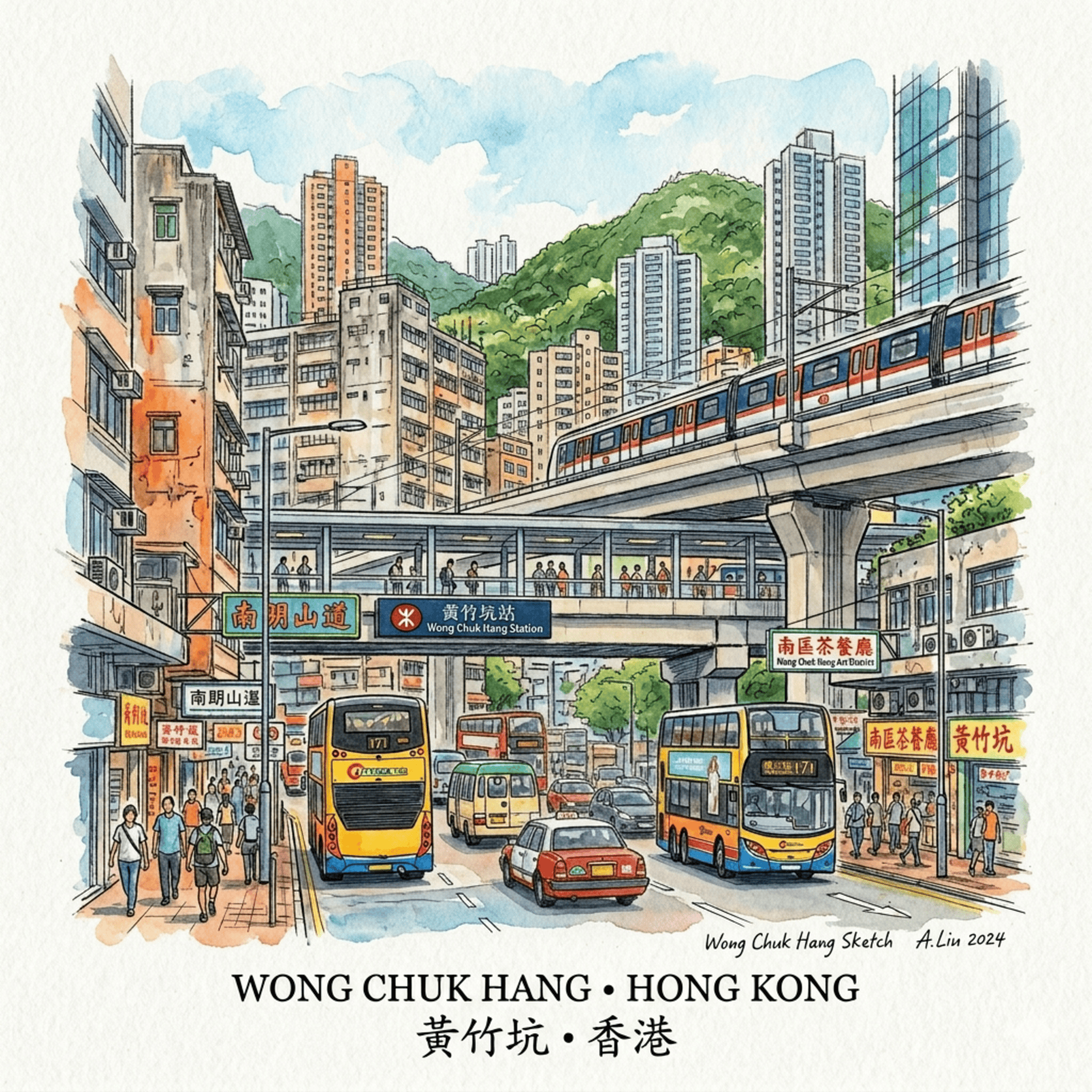
Most people pass through Wong Chuk Hang without pausing. They step off the MTR South Island Line into a neighbourhood that looks, at first glance, like any other post-industrial district mid-reinvention — repurposed factory buildings, a gallery on the second floor, a coffee bar where a warehouse used to be.
Wong Chuk Hang is all of that. But the valley it sits in has been accumulating history for roughly three thousand years. There are Bronze Age rock carvings here. A Vatican seminary that quietly outmanoeuvred French imperialism. The spot where a fisherman's casual answer to a simple question accidentally gave this city its name. A school that grew from the ruins of a paper mill. And a road with a charming name that is, in fact, a tobacco company's private joke on the city map.
None of this is on a tourist board. Almost none of it is signposted. But all of it is still here — embedded in the streets, the buildings, the water channels — waiting for someone who walks slowly enough to read it.
This article is part of our broader guide to Hong Kong Island: A Historical Travel Guide. If you're building an itinerary around the Southern District, start there. Come back here when you want to go deeper into one of its most quietly extraordinary corners.
Listen to the historical stories told in detail (For subscribers only)
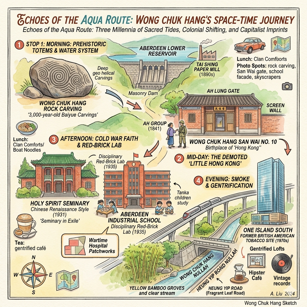
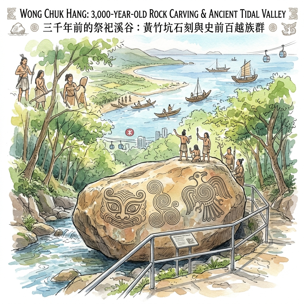
1. The Rock You Walk Past Was Carved 3,000 Years Ago — And the Valley Around It Was Once the Sea
Follow South Wind Road off the main drag, step into the narrow, tree-shaded gully above Wong Chuk Hang Nullah, and you'll find a sandstone boulder about the size of a wardrobe lying at the edge of a stream. It is fenced off with metal railings. There is a modest plaque. Most people glance and move on.
They're looking at Hong Kong Island's largest prehistoric rock carving — formally gazetted as a declared monument in 1984, and estimated to be approximately three thousand years old.
The surface of the boulder carries three distinct clusters of geometric spirals, their grooves deep and fluid, the lines turning in on themselves in patterns that recall both Chinese bronze-age vessel ornaments and something more primal — an eye, a vortex, a signature. Archaeologist William Meacham spent years studying rubbed impressions of the weathered designs and concluded that the right side of the carving depicts a highly stylised bird totem, while the left presents a layered beast-face composed of concentric eye-shapes and curving lines. His interpretation: these were the clan markers of a Baiyue people who used this valley as a ritual boundary, a place to declare territory and conduct ceremony.
An older school of thought reads the spirals differently — as water-suppression symbols, a practice of carving whirlpool and thunder motifs near streams to ritually contain floods and protect those who sailed out to sea from the valley's mouth.
Neither interpretation has been definitively proved. That unresolved tension is, in its own way, the most honest thing about a prehistoric site. The carvings ask questions they will never answer.
What makes the location itself remarkable is something most visitors completely miss. The valley today sits roughly a kilometre inland. It feels landlocked, agricultural, interior. But geological surveys tell a different story: during the Bronze Age, the coastline extended much further north. This gully was likely a tidal inlet — a place where the sea came in along the stream — which would explain why a group of maritime-oriented people chose it for their most permanent markings. They were not an inland farming tribe. They were coastal people, and this was the edge between their two worlds.
The carving doesn't just predate British colonisation, as historians are quick to note. It directly refutes the colonial-era claim that Hong Kong was a barren rock before 1841. This valley had people, ritual, artistic tradition, and maritime culture for millennia before anyone in London drew a line on a map.
Walk this: From Wong Chuk Hang MTR, head south on Nam Fung Road and look for the signed path into the nullah. The boulder is a ten-to-fifteen-minute walk. Go on a weekday morning if you can — the gully is quiet, the light is good, and you'll have the carving largely to yourself.
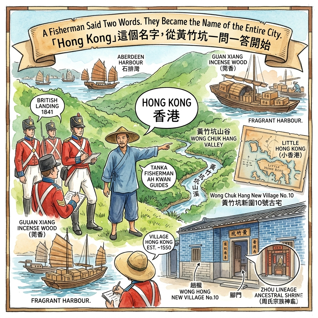
2. A Fisherman Said Two Words. They Became the Name of the Entire City.
In 1841, British forces landed on Hong Kong Island. They needed to get from the southern shore to the northern settlements, and they had no reliable map and no shared language with anyone they met.
A Tanka fisherman — a member of the boat-dwelling communities who had lived on the water around this coastline for generations — agreed to lead them. His name, recorded in various colonial accounts, was Ah Kwan, or Chan Kwan. He guided the soldiers across the island, passing through the valley we now call Wong Chuk Hang, before ascending north towards what would become Sheung Wan.
At some point during the crossing, the British soldiers asked him what this place was called. He answered in the Tanka dialect: Hong Kong.
The soldiers wrote it down. And then, with the particular efficiency of empire, they applied the name to the entire island.
The village Ah Kwan was referring to was a small settlement in this valley — established during the Ming dynasty around 1550, given its name because the nearby harbour at what is now Aberdeen was a major transit port for guan xiang, the prized incense wood traded down from Dongguan. Hong Kong — fragrant harbour — was a local name for a local place. It had been here for nearly three hundred years before anyone decided it should refer to something much larger.
By 1759, the village had been rebuilt by the Zhou clan after a period of abandonment caused by the Qing dynasty's ruthless coastal evacuation orders — the so-called Haijin, which emptied the shoreline to starve out the loyalists of the Southern Ming. The rebuilt village was renamed Hong Kong Wai — adding wai, meaning fortified settlement — though, curiously, no physical walls were ever built.
When the British put "Hong Kong" on their maps, they were borrowing a name from a two-hundred-year-old farming village in a valley most of them had never properly visited.
By 1898, the colonial administration had a problem. The name "Hong Kong" now referred to the entire island, the harbour, and the wider territory. Something had to be done about the original village, which was still there, still inhabited, still called Hong Kong. The solution was to demote it on official maps to Little Hong Kong — a place forced to shrink itself so that the empire's abstraction could grow.
The family name of the Zhou clan still marks the landscape here. Walk to the New Village today and you'll find the Wong Chuk Hang New Village No. 10 ancestral house, a blue-brick structure from the 1890s rated as a Grade II historic building — the oldest surviving structure in the new settlement. Its main hall still holds a finely carved ancestral shrine to the Zhou lineage. Nearby, Shouson Hill and Shouson Village take their name from Sir Shouson Chow, one of colonial Hong Kong's most significant Chinese leaders, who grew up in this village and was honoured by King George V in 1936.
Walk this: The New Village is a short walk from the MTR station. The No. 10 house is quiet, unobtrusive, and almost entirely overlooked — a blue-brick room with an ancestor altar, sitting in a lane between contemporary housing blocks. Budget twenty unhurried minutes. Nothing else in Hong Kong looks quite like it.
3. The Vatican Chose This Valley to Outmanoeuvre France
In the 1920s, the Catholic Church had a problem with France.
For decades, the French government had operated something called the Protectorate — a quasi-legal arrangement that gave Paris the right to represent Catholic interests in China, intervene in the Church's affairs, and effectively veto direct diplomatic relations between Rome and Beijing. For the Vatican, this was theologically embarrassing and politically suffocating.
In 1919, Pope Benedict XV issued the apostolic letter Maximum Illud, a document that pushed the Church firmly toward training indigenous clergy in mission territories — a move designed to separate Catholicism from European colonialism. The message was clear: Rome wanted the Chinese Church to belong to China, not to France.
The immediate practical problem was: where do you train that clergy without landing in French-controlled territory?
The answer turned out to be a hillside in Wong Chuk Hang.
In the mid-1920s, Celso Costantini — the Vatican's first Apostolic Delegate to China — negotiated directly with the British Governor of Hong Kong, Sir Cecil Clementi, who offered "relevant facilities" for the Church's land acquisition. For roughly three thousand US dollars, the Vatican purchased a ten-hectare plot on the lower slopes of Nam Long Shan, on what is now Welfare Road, and began planning a regional seminary to serve the Catholic dioceses of southern China — Guangdong, Fujian, Guangxi, and Hainan.
Why not Guangzhou? Costantini was explicit about this in his letters to Rome. Guangzhou's apostolic vicariate was administered by the Paris Foreign Missions Society. Building the seminary there would place it directly within the shadow of the French Protectorate. Hong Kong, under British rule, sat outside French influence entirely — and would remain politically stable regardless of what happened on the mainland.
The South China Regional Seminary opened in October 1931, managed by the Irish Jesuits under Father Thomas Cooney. For nearly two decades, it trained local Chinese priests and quietly built the infrastructure of a Southern Chinese Catholic community independent of European colonial patronage.
Then came 1949.
When the People's Republic was established and every other seminary on the mainland closed within a few years, the one that had been strategically placed just beyond the reach of politics became the only one still standing.
Overnight, the seminary transformed into a Cold War refuge. Priests who had fled southward from the mainland — some of them already ordained, some mid-study — arrived in Hong Kong and were absorbed into the institution. After completing their theology and ordination, many were dispatched to Chinese diaspora communities across Southeast Asia, the Americas, and Europe. A few slipped back into China. Several spent years in labour camps and emerged, by most accounts, unchanged in their convictions.
In 1964, the Vatican formally dissolved the Regional Seminary and transferred the campus to the Hong Kong Diocese, which renamed it the Holy Spirit Seminary — the name it carries today, at 6 Welfare Road. It remains the only institution in Hong Kong that trains Catholic priests.
The 1931 South Building is the architectural argument for visiting. Its roofline is glazed green tile — unmistakably Chinese in form — sitting on a red brick body that is unmistakably European. The 1957 Great Chapel's altar is framed by a wooden baldachin modelled on the decorative gate-within-a-gate design of northern Chinese courtyard architecture. The building is a physical manifesto of theological inculturation: the deliberate translation of a Western religious form into Chinese spatial language.
Walk this: The seminary grounds and heritage museum are partially open to the public. The chapel interior is worth seeking out specifically for the baldachin — it's one of the most quietly unusual pieces of ecclesiastical design in Hong Kong.
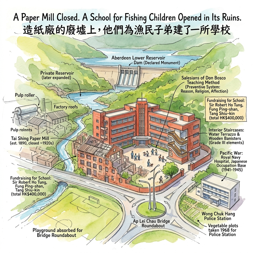
4. A Paper Mill Closed. A School for Fishing Children Opened in Its Ruins.
In 1890, a merchant established the Tai Shing Paper Mill in the floor of the Wong Chuk Hang valley, building a private reservoir on the slopes above it to supply the industrial quantities of cooling water that paper production demanded.
By the late 1920s, the colonial government needed that reservoir more than the mill did. Hong Kong Island's western districts were running short on water, and the Tai Shing reservoir was exactly where it needed to be. The government compulsorily purchased it for HK$460,000, expanded it into the public Aberdeen Lower Reservoir, and the paper mill, stripped of its water supply, shut down and left behind a derelict site.
The timing was bad for the mill. For a specific group of children, it may have been quietly fortunate.
In the 1920s, the Tanka fishing communities of the Southern District were facing a particular kind of structural poverty. Their children had limited access to formal schooling. Without education, they had no path into the colonial economy beyond the water. Juvenile delinquency, by contemporary accounts, was rising.
In 1921, a coalition of prominent Chinese community leaders — among them Liu Zhubo, Sir Shouson Chow, Fung Ping-shan, and Lo Cheuk-ham — proposed an industrial school specifically for these young people, modelled on Western vocational education institutions. Sir Robert Ho Tung and Fung Ping-shan each donated HK$100,000 to start the fund. Tang Shiu-kin led a wider fundraising effort that brought the total to HK$400,000.
Lo Cheuk-ham negotiated with the government, which agreed to release the derelict Tai Shing Paper Mill site as the building ground. Construction began in 1932. The Aberdeen Industrial School opened in 1935, with the Salesians of Don Bosco — a Catholic teaching order founded in Turin in the nineteenth century specifically for marginalised youth — placed in charge of its education.
The Salesian method, rooted in their founder John Bosco's "Preventive System," was unusual for its time. No corporal punishment. A boarding model. An atmosphere that emphasised reason, religion, and affection rather than fear and hierarchy. The curriculum focused on carpentry, mechanics, and electrical trades — skills that could lift a fishing community's children into the industrial economy without asking them to abandon their origins.
What makes this story genuinely complicated is that it was never purely philanthropic. The school was also an exercise in social control — a project in which the colonial government, Chinese merchant elites, and a Catholic missionary order collaborated to transform a marginalised community into a disciplined working class. Progress and regulation arrived together, as they so often do.
During the Pacific War, the school building's solid construction made it strategically useful. The Royal Navy requisitioned it in June 1941 as a volunteer corps base, converted it in December into an auxiliary hospital, and then the Japanese military took it over for the occupation's duration. Teaching resumed in 1945. The school was formally renamed Aberdeen Industrial School in 1952.
In the decades that followed, the school's land was repeatedly carved away by government development priorities: vegetable plots taken for a police station in 1968, the main playground absorbed by a roundabout for the Ap Lei Chau Bridge approach. The school is still there, still operating, at 1 Wong Chuk Hang Road.
The original 1935 wing — red brick, washed-stone render, water terrazzo staircases with wooden banisters — has been listed as a Grade III historic building. It is one of the earliest surviving examples in Hong Kong of the International Style applied to educational architecture, with Art Deco detailing that gives the whole structure a quietly composed solidity. The Aberdeen Lower Reservoir dam, directly above, is a declared monument.
Most visitors see the school and the reservoir as two separate things. They are not. Both are the same site, read thirty years apart — the same land, the same water, the same valley, transformed twice.
Walk this: The school exterior is visible from Wong Chuk Hang Road. For the reservoir, take the Country Park trail from the Aberdeen Reservoir Road entrance — it's a straightforward thirty-minute walk and offers the best views of the dam structure.
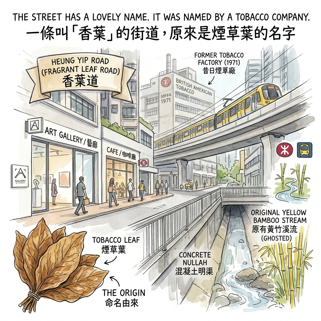
5. The Street Has a Lovely Name. It Was Named by a Tobacco Company.
Heung Yip Road runs through the heart of the contemporary Wong Chuk Hang district. The name translates as Fragrant Leaf Road — the kind of poetic, softly evocative name that fits naturally in a neighbourhood now known for galleries and studios.
Almost no one knows what it actually refers to.
In the 1960s, British American Tobacco Company (Hong Kong) Ltd. — one of the world's largest cigarette manufacturers — relocated its production facilities to the newly reclaimed land in Wong Chuk Hang, on the site now occupied by One Island South. In 1971, the company submitted a formal request to the Urban Council proposing that the new dual-carriageway road running alongside the Wong Chuk Hang Nullah be named Heung Yip Road. The application was straightforward about the origin of the name: heung yip means tobacco leaf. The company was naming a public road after its own product.
The application was approved and gazetted in September 1972.
This is worth sitting with for a moment. A multinational corporation — the same company that was, in the same decade, fighting public health regulators around the world over the question of whether cigarettes caused cancer — successfully lobbied the colonial government to inscribe its industrial identity into the permanent geography of a Hong Kong neighbourhood.
The people who now walk Heung Yip Road in search of contemporary art, good coffee, and quiet afternoons among the galleries are, whether they know it or not, walking a tobacco company's signature on the city.
The most durable form of corporate branding is not an advertisement. It's a street name.
This story is also part of a larger ecological transformation that the name obscures entirely. Wong Chuk Hang — the place name itself — means Yellow Bamboo Pit, a reference to the natural stream that once ran down from Nam Long Shan, its banks thick with yellow bamboo. That stream was the same water source that Bronze Age people may have carved beside, that irrigated the Zhou clan's farmland, that cooled the Tai Shing paper machines.
By the 1970s, the stream had been rerouted into a concrete nullah — the drainage channel that now runs alongside Heung Yip Road — to carry away industrial runoff from the factories built on the reclaimed wetlands where the stream's natural estuary had once been.
The water that once sustained a tidal inlet and a Bronze Age ceremony now moves under concrete, invisible, between tobacco residue and gallery opening nights.
The MTR South Island Line, which opened in 2016, accelerated what reclamation and light industry had already begun. Factories became studios. Studios became galleries. Galleries attracted investment grade office buildings — Landmark South, South Island Place — and then the hotels. The transformation has been rapid enough that Wong Chuk Hang's industrial past already feels like heritage rather than recent memory, which is exactly the condition that makes it disappear.
Walk this: Before entering any of the Heung Yip Road galleries, walk the full length of the nullah for ten minutes. The concrete channel is unglamorous but instructive. It is the ending of a story that began with a tidal Bronze Age valley, and seeing it clearly makes the galleries — however good they may be — read as something other than a neutral creative space.
Hidden Gem Worth Finding
The Wong Chuk Hang New Village No. 10 ancestral house deserves more than a passing mention. Set into a quiet lane in the New Village, this blue-brick structure from the 1890s is rated a Grade II historic building and is the oldest surviving architecture in the settlement. Its three-bay, two-verandah layout is a textbook example of Cantonese vernacular domestic design — footstool door, latticed panel, main door, spirit screen, ancestor altar. The Zhou clan shrine inside is still tended. Nothing about it announces itself. There are no queues, no entrance fee, no explanatory panels. It is just a very old room where a family has been placing offerings for over a century, sitting quietly between two apartment blocks. Go slowly. Look at the brickwork. Look at the altar. Stay as long as feels right.
Five Stories, One Through-Line
Wong Chuk Hang is not an anomaly. Every city has places like this — corners where the sediment of history is unusually dense, where the past has not been cleared away so much as buried under successive reinventions. The particular interest of this valley is in the pattern it reveals.
Every era that moved through here took something and left something. The Baiyue people left carvings. The Ming settlers left a name. The British took that name and inflated it to cover an entire territory. The Vatican left a seminary and a Cold War legacy. Chinese merchant philanthropy left a school. British American Tobacco left a road sign. The MTR left galleries.
And underneath all of it, rerouted but still flowing, is the water — from tidal inlet to irrigation channel to industrial coolant to concrete nullah. The transformation of that water is, in miniature, the entire three-thousand-year story of this place.
This is what historical travel asks of you: not the ability to identify dates and dynasties, but the willingness to read what is in front of you as a palimpsest — a surface that has been written on, partially erased, and written on again, many times over. The layers do not cancel each other out. They accumulate.
What you see in Wong Chuk Hang today is not the end of the story. It is the most recent layer on a very old surface.
If this kind of reading appeals to you, our guide to Hong Kong Island South covers the full arc of the Southern District's historical landscape — from the deep harbour at Aberdeen to the headlands at Stanley. And if you'd like pieces like this one delivered directly to you, our newsletter goes out every week.
Getting There & Planning Your Visit
By MTR: Take the South Island Line to Wong Chuk Hang Station (黃竹坑站). Most historical sites in this article are within fifteen minutes on foot. Exit B brings you closest to the valley and Nam Fung Road.
By bus: Routes 70, 71, 72, and 91 connect Wong Chuk Hang to Central, Causeway Bay, and Stanley. Alight at Wong Chuk Hang Road.
Suggested walking order (allow 3 to 4 hours): Wong Chuk Hang MTR → Bronze Age Rock Carving (Nam Fung Road nullah path) → Holy Spirit Seminary, 6 Welfare Road → Aberdeen Industrial School, 1 Wong Chuk Hang Road → New Village No. 10 ancestral house → Heung Yip Road nullah walk → Gallery district
Where to Stay
Wong Chuk Hang and the immediately surrounding area now have several options well-suited to historically minded visitors who want to walk the Southern District over multiple days.
- South Island-adjacent business hotels (Wong Chuk Hang and Ap Lei Chau): A cluster of three- and four-star properties has opened in the past decade, offering good access to both the MTR and Aberdeen Promenade. Clean, functional, and competitively priced outside peak season.
- Aberdeen waterfront guesthouses: A short bus or taxi ride connects Wong Chuk Hang to Aberdeen proper, where smaller guesthouses and heritage-adjacent accommodation give a different texture to the stay — especially in the early mornings when the harbour is quiet.
- Booking tip: December through February is peak season. Book at least three weeks ahead. Late September through November offers the best combination of weather and availability.
Recommended Ways to Go Deeper
- CACHe (Antiquities and Cultural Heritage Experience): The Conservancy Association Centre for Heritage offers occasional guided walks in the Southern District, including Wong Chuk Hang. Their researchers know the archive sources behind many of the sites in this article. Check their current programme before your visit.
- Hong Kong Museum of History (Tsim Sha Tsui): The permanent exhibition The Hong Kong Story provides the broader chronological framework that makes a walk through Wong Chuk Hang significantly more legible. Worth two hours before you arrive in the valley.
- Aberdeen Lower Reservoir trail: A self-guided walk via the Country Park entrance on Aberdeen Reservoir Road. The dam itself is a declared monument, and the trail gives context for the Tai Shing Paper Mill's water infrastructure — and the industrial school built in its wake.
Q & A
Explain the link between ancient rock carvings and water rituals.
The link between ancient rock carvings and water rituals in Wong Chuk Hang is centered on the "Thunder Pattern Suppressing Water" theory (雷紋鎮水說), which suggests that these carvings served as shamanistic tools to manage the spiritual and physical power of water.According to the sources, several key factors establish this connection:
- Sacred Liminal Space: During the Bronze Age (approximately 3,000 years ago), the Wong Chuk Hang valley was not deep inland as it is today, but was likely a river mouth or estuary where tides moved in and out with the stream. This location represented a "sacred boundary" between the land and the sea, making it a specific site for prehistoric rituals.
- Symbolic Imagery: The carvings, located next to a natural stream near Nam Fung Road, feature deep geometric spiral or swirl patterns. In ancient Chinese iconography, these are often referred to as "Lei-wen" (thunder patterns) or water vortex patterns.
- Shamanistic Functions: The sources outline three primary ritualistic goals for these carvings:
- Suppressing Floods: The geometric symbols were believed to possess magical functions to 鎮壓山洪 (suppress mountain floods), protecting the community from natural disasters.
- Praying for Clean Water: The carvings were used to pray for a constant and清冽 (clean/pure) water source, which was vital for the survival of the prehistoric inhabitants.
- Safe Passage for Sailors: Because the stream led to the sea, the carvings were intended to pioneer and protect seafarers who navigated these waters.
These carvings are significant because they demonstrate that prehistoric Hong Kong was part of a larger spiritual and cultural network of the Baiyue ethnic groups in the Lingnan region, where human survival was deeply intertwined with ritualized control over the natural environment.
Tell me more about the 'Argun's Map' legend.
The "Argun's Map" legend, known locally as "Argun's Wayfinding" (阿群帶路), refers to a pivotal (and partly mythologized) event in 1841 that explains how a single village name became the name for the entire territory of Hong Kong.According to the sources, here are the key components of this legend and its historical significance:The Encounter and the Journey
- The Guide: The legend centers on Chen Qun (陳群), a Tanka (water person) fisherman popularly known as "Argun".
- The Route: In the early days of the British landing in 1841, troops faced significant language and navigational barriers. Argun led the British forces from Stanley and Aberdeen (Shek Pai Wan) through the Wong Chuk Hang valley to reach the northern part of the island, which is now Sheung Wan.
The Naming of "Hong Kong"
- The Linguistic Slip: As the group passed through Hong Kong Wai (Hong Kong Enclosure, the historic heart of Wong Chuk Hang), the British soldiers asked for the name of the place. Argun replied in his Tanka dialect: "Hong Kong".
- Expansion of the Name: The British recorded this as the name of the location and eventually used it as a synecdoche—a linguistic device where a part represents the whole. Consequently, the name of this specific agricultural village was expanded to cover the entire island, while the original village was later demoted on colonial maps to "Little Hong Kong" to avoid confusion.
Cultural and Political Symbolism
- The Colonial Emblem: This legend was so central to the British narrative of the city's founding that the image of Argun leading a British ship was depicted on the colonial coat of arms and badges of Hong Kong.
- The "Cooperation Myth": From a historiographical perspective, scholars point out that this legend served a specific purpose. It recontextualized the military occupation of the island as a myth of "Sino-British cooperation," portraying a local inhabitant assisting the British rather than highlighting the reality of imperial military force.
Today, the legacy of this legend remains visible in South Island geography through "Argun Road" (阿群道), and the physical location where the encounter supposedly occurred is still represented by the remnants of Wong Chuk Hang Old Wai and New Wai.
Reference and Further reading
- 黃竹坑- accessed June 3, 2026,
- 黃竹坑石刻- 古蹟天行樂Skywalker's Heritage - 天行足跡, accessed June 3, 2026,
- 黄竹坑石刻- accessed June 3, 2026,
- 香港仔和黃竹坑的新與舊| 港文化18區, accessed June 3, 2026,
- 石頭上的香港史原文摘錄 - 讀書- accessed June 3, 2026,
- 東方之珠--香港| 名勝古蹟| 大紀元, accessed June 3, 2026,
- 黃竹坑舊圍- accessed June 3, 2026,
- 黃竹坑舊圍Wong Chuk Hang Kau Wai Village | 香港文化古蹟資源中心Hong Kong Resource Centre for Heritage, accessed June 3, 2026,
- 聖神修院- accessed June 3, 2026,
- 華南總修院/聖神修院的人.事.物 - 天主教研究中心, accessed June 3, 2026,
- 華南總修院簡史及其對教會當前的影響, accessed June 3, 2026,
- 寄宿部 - 學校歷史- 慈幼會香港仔工業學校, accessed June 3, 2026,
- 踏上舊日歷史足跡 - 蒲窩青少年中心, accessed June 3, 2026,
- 香港仔工業學校- accessed June 3, 2026,
- 香港仔工業學校八十五周年校刊, accessed June 3, 2026,
- 香葉道 - 香港巴士大典, accessed June 3, 2026,
- 黃竹坑石刻- 香港法定古蹟, accessed June 3, 2026,
- 香港島的法定古蹟之八香港石刻之旅 - York Region Times 約克時報, accessed June 3, 2026,
- 黄竹坑新圍 accessed June 3, 2026,
- 周壽臣- accessed June 3, 2026,
- 黃竹坑新圍10號舊宅 - Soldier 的世界, accessed June 3, 2026,
- 學院歷史 - 聖神修院神哲學院, accessed June 3, 2026,
- 【眾裡尋祂】從聖神修院神哲學院到「聖神三院」〔作者︰蔡惠民〕 - 公教報, accessed June 3, 2026,
- 聖神修院神哲學院, accessed June 3, 2026,
- 聖神修院 - accessed June 3, 2026,
- 香港仔水塘- accessed June 3, 2026,
- 香港仔工業學校- 古蹟天行樂Skywalker's Heritage - 天行足跡, accessed June 3, 2026,
- 香港仔工業學校 accessed June 3, 2026,
- 主頁- 慈幼會香港仔工業學校| 寄宿部, accessed June 3, 2026


Wong Chuk Hang sits within the Southern District of Hong Kong Island, one of the territory's most historically rich and least visited areas. For the full regional picture, see our guide to Hong Kong Island: A Historical Travel Guide. For the rock carvings in their wider coastal context, read Hong Kong's Prehistoric Rock Carvings: A Walker's Field Guide.