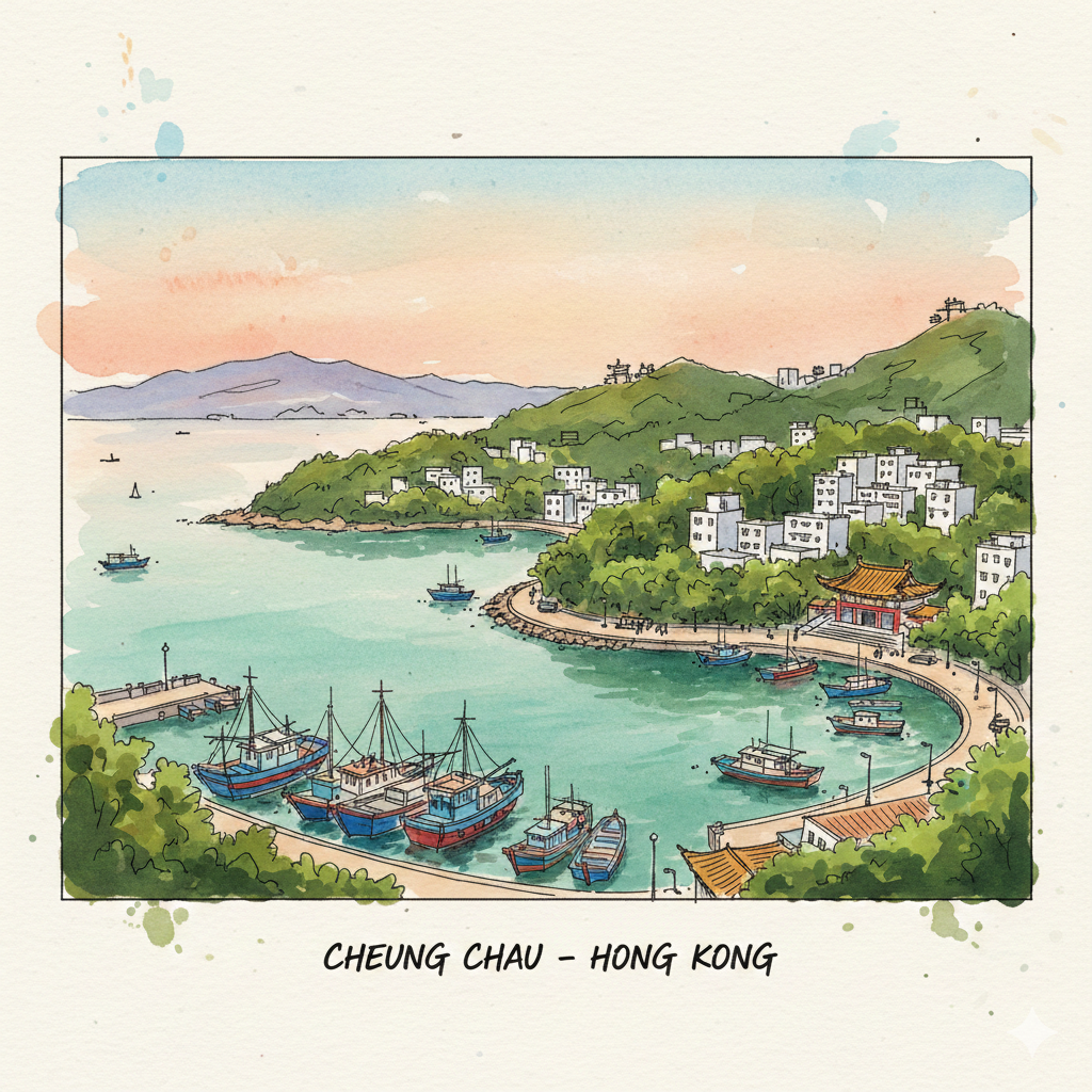
(ENG) The Soul of Cheung Chau: A Deep-Dive into Land, Power, and History
Explore the hidden legal fractures of Cheung Chau, from colonial segregation on the southern heights to the fall of the Wong Wai Tsak Tong clan hegemony.


How did the Wong Wai Tsak Tong clan control land for nearly a century?
How did the 1919 Residence Ordinance enforce racial segregation on the top of Cheung Chau?
How did temples and local deities act as informal land administrators?
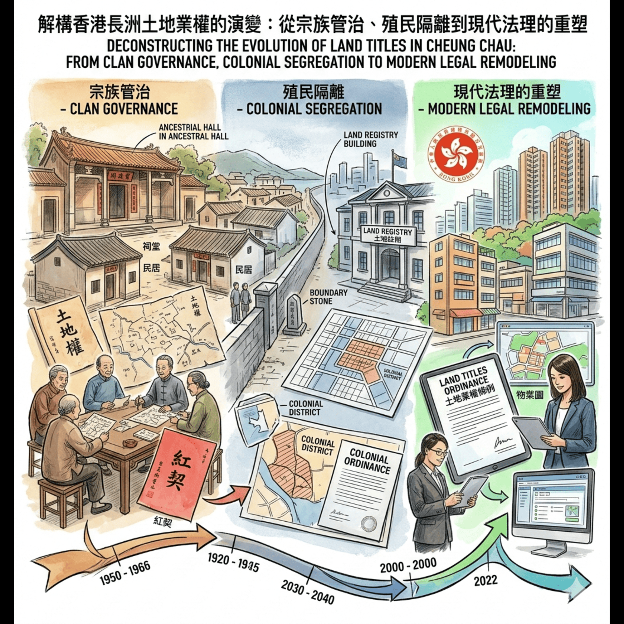
Following the article "The Dumbbell Island’s Hidden Layers: 5 Surprising Histories of Cheung Chau", we will continue to explore in detail the evolution of land ownership in Cheung Chau, Hong Kong: from clan governance, colonial isolation to the reshaping of modern legal principles. Friends who are interested can also read the article "Cheung Chau’s Pirate King: Beyond the Cave and Into the Maritime Frontier".

For many, Cheung Chau is defined by the ephemeral—the scent of steamed buns during the Jiao Festival or the vibrant, sun-drenched chaos of the seafood waterfront. Yet, beneath this veneer of a weekend getaway lies a landscape defined by rigid legal fractures and a century of social friction. To truly understand the "soul" of this island, one must look past the ferry piers and toward the soil itself.
Physically, the island is a "dumbbell," two mountainous ends tethered by a slender sandy isthmus where the village huddles. This shape has dictated the island's rhythm for centuries, but its history is etched even more deeply into the neighborhoods that can still be navigated on foot today. From the weathered lintels of the village to the granite-strewn southern heights, the island’s topography tells a story of five pivotal transitions: the enduring hegemony of a single clan, the architecture of racial segregation, the informal rule of temple guilds, the colonial survey that mapped sovereignty into existence, and the late 20th-century legal reforms that finally granted residents direct property rights.
Listen to the historical stories told in detail (For subscribers only)
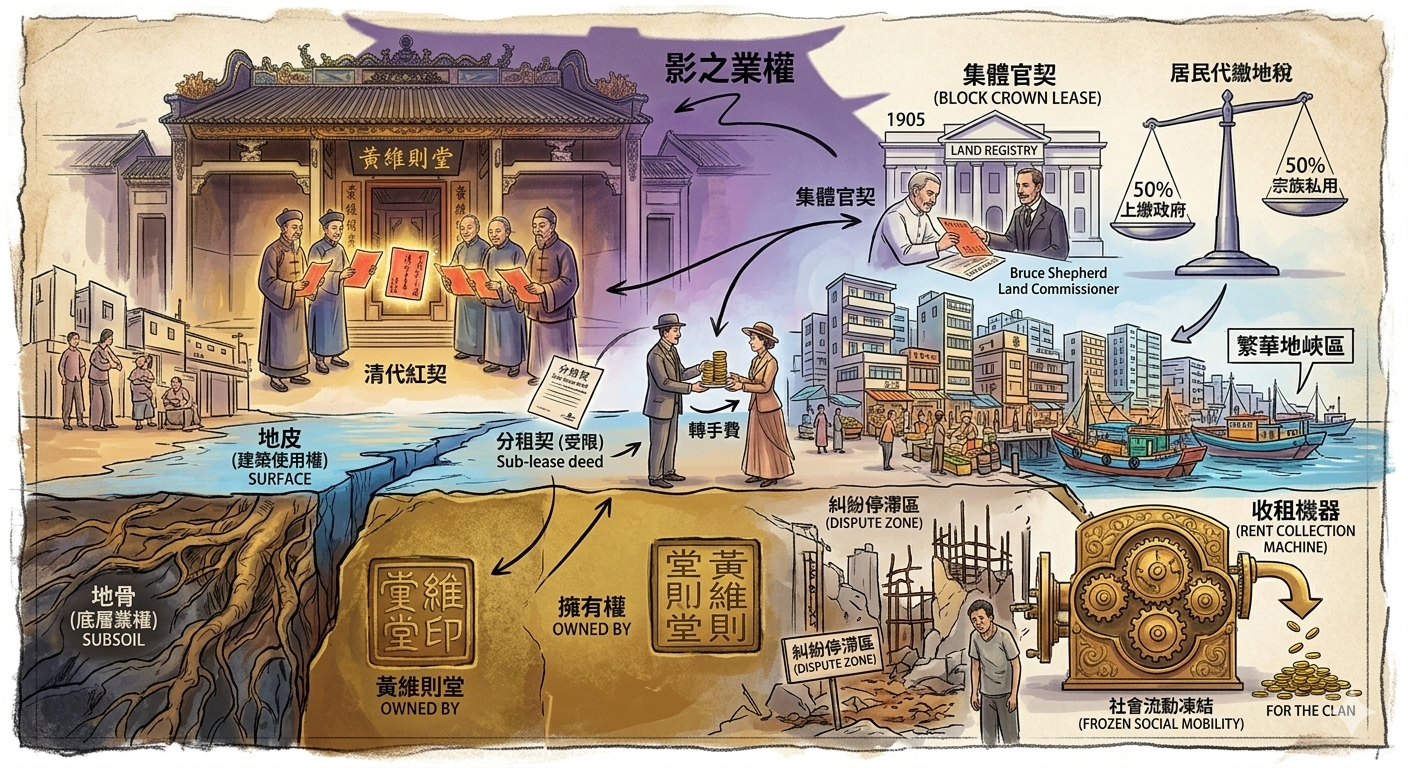
The Clan as Proxy: The Wong Wai Tsak Tong Hegemony
In the administrative logic of the Qing Dynasty, the state rarely dealt with individuals, preferring "proxy rule" via influential gentry or clans to manage tax collection. On Cheung Chau, this legacy was personified by the Wong Wai Tsak Tong, a clan entity that maintained a near-century-long grip on the island's territory.
The clan’s power was rooted in the traditional concept of "Ground vs. Surface" (地骨 vs. 地皮) rights. While residents owned the "surface" (the physical structures and use of the land), the Wong Wai Tsak Tong held the "ground" (the underlying title). When the British took over the New Territories in 1898, they prioritized stability over radical reform. In 1905, Acting Land Officer Bruce Shepherd utilized the clan’s Qing-era "Red Deeds" to register them as the sole "Double Landlord" (二地主) for 619 lots across the island under a Block Crown Lease.
This system effectively froze Cheung Chau’s social structure. For decades, residents were merely sub-lessees, caught in a form of colonial-era feudalism. Any resident wishing to sell, mortgage, or transfer their property was required to obtain the clan’s consent and pay a significant "transfer fee." Even as the rest of Hong Kong moved toward modern individual property rights, Cheung Chau remained a landscape where the soil was a shared burden between the occupant and an ancestral proxy. The dominance of the clan in the valley, however, stopped abruptly where the hills began to rise.
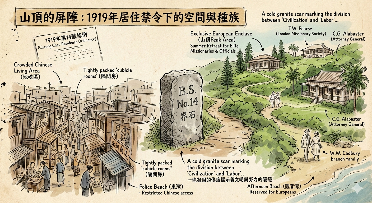
The Forbidden Peak: 1919 and the Architecture of Segregation
As the post-WWI era brought increased social stratification to the colony, a new boundary appeared on Cheung Chau. While the Chinese village bustled on the crowded isthmus, the southern heights—the "Peak" of Cheung Chau—were legally transformed into a sanctuary for European and American missionaries seeking a "sanatorium-like" environment.
In 1919, the colonial government enacted the Cheung Chau (Residence) Ordinance, providing the legal machinery for racial and class-based exclusion.
"Except with the consent of the Governor in Council no person shall reside within the area... This shall not apply to any person being a person in the bona fide employment of a person permitted to reside within the area."
While Chinese unofficial members of the Legislative Council, such as Ho Fook and Lau Chu Pak, decried the law as an insult to the King’s subjects, the government defended it under the guise of "economic protection." They argued that exclusion was necessary to prevent developers from building the "cubicles" (tenement housing) that would ruin the tranquility required by elite residents like T.W. Pearse of the London Mission, W.W. Cadbury, and the Attorney General, C.G. Alabaster.
This created a profound "Spatial Governance." The island was split into two worlds: the commercial Chinese village and the manicured "European Reservation." This segregation even extended to the water’s edge: Kwun Yam Wan (Afternoon Beach) was reserved for Europeans, while Chinese residents were relegated to Tung Wan (Police Beach). The landscape was no longer just geography; it was a map of colonial privilege.
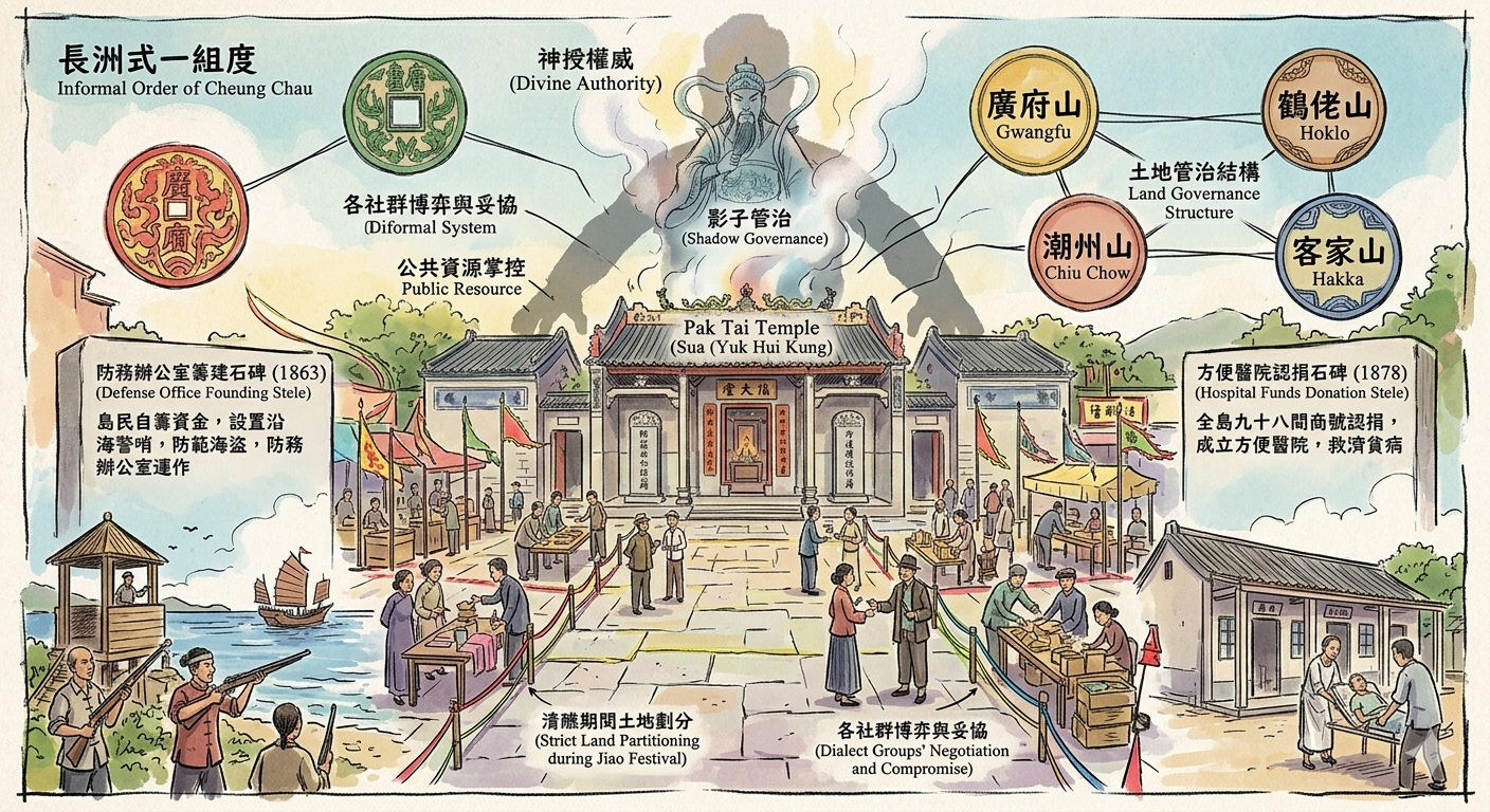
Temple Politics: The "Four Mountains" and Informal Rule
Before the British established a police station or a land registry, Cheung Chau was governed by the "law of the gods." In the absence of direct state administration, power resided in the temples and the dialect guilds—the Cantonese, Hoklo, Chiu Chow, and Hakka—collectively known as the "Four Mountains" (方言群體).
The Pak Tai Temple (Yuk Hui Kung) served as much more than a religious site; it was the island’s de facto "Defense Office" and administrative hub. Between 1863 and 1870, the temple committee managed coastal patrols and public order, funding these operations through levies on the merchant community.
To find the island's original "land registry," one must look at the stone tablets, or steles, preserved within the temple. These inscriptions record the donation of lands and the founding of the Fong Pin Hospital in 1878. These stones represent a "sacred" land record, proving that social order and property usage were managed through community consensus long before the arrival of colonial surveyors and their scientific precision.
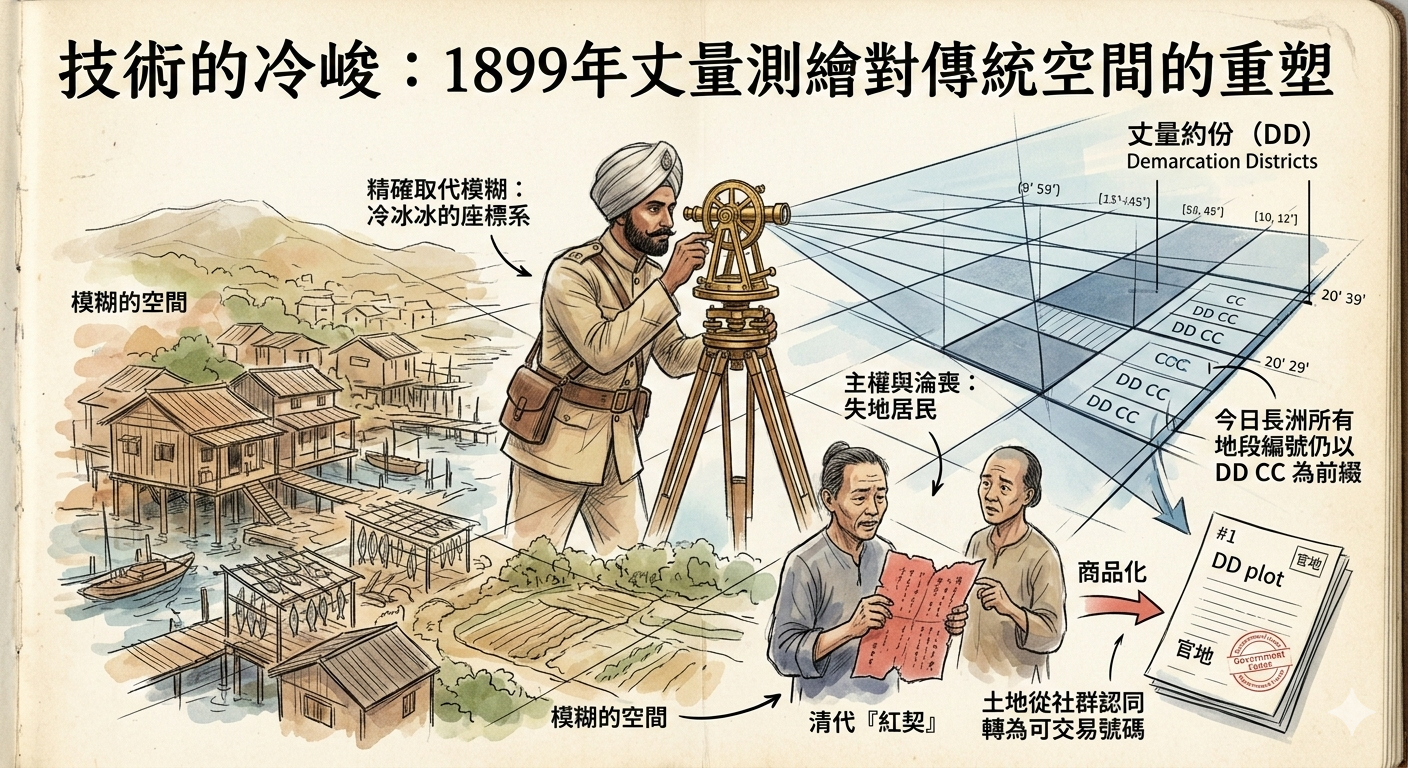
The Surveyor’s Transit: Mapping as an Act of Sovereignty
In 1899, the British began the process of making the "vague" territory of the New Territories "legible" to the state. Armed with transits and chains, Indian surveyors under Bruce Shepherd began mapping Cheung Chau, turning an ancestral landscape into a colonial asset.
The surveyors demanded that residents produce Qing-era "Red Deeds" to prove ownership. Many residents, either illiterate or skeptical of the new regime, failed to report. Consequently, land held by families for generations was classified as "Crown Land" and leased back to them. This survey codified the island into "Demarcation Districts" (specifically DD CC).
This technical exercise was a fundamental transformation of identity. It turned the island from a "means of production"—where land was valued for rice paddies and fish-drying grounds—into a "commodity" and "security." The resident was no longer a villager with ancestral ties to the dirt; they were a "government lessee," and the state now held the ultimate power to dictate the land’s use.
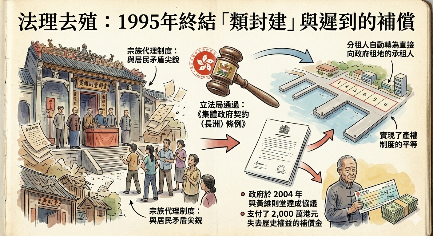
The 1995 Reform: A Late Decolonization of the Land
The friction created by the 1905 Block Crown Lease survived for nearly a century, but by the 1990s, the "Double Landlord" system had become untenable. Residents were no longer willing to pay transfer fees to the Wong Wai Tsak Tong for land they had occupied for generations.
In 1995, the government passed the Block Crown Lease (Cheung Chau) Ordinance, finally abolishing the special status of the Wong Wai Tsak Tong. This was a strategic "legal decolonization" intended to resolve historical grievances before the 1997 handover. To settle the claim, the government eventually paid the clan HK$20 million in 2004—a pragmatic compromise to "buy back" the proxy rights granted a century earlier.
This reform finally granted Cheung Chau residents the same direct property rights enjoyed by the rest of Hong Kong. However, the legacy of the past remains; complex "Small House Policy" (Ding Rights) disputes still simmer in the island's rural pockets, proving that the struggle for land and identity is never truly settled.
THE WALKER'S ADDENDUM: HIDDEN GEMS
The Fong Pin Hospital Ruins: Located on San Hing Back Street, this hospital was founded in 1878 and funded by 98 local shops. Today, its weathered facade and granite lintels offer a haunting glimpse into the "informal" governance that provided a social safety net when the colonial state would not.
Boundary Stone No. 14: A vital piece of archaeological evidence for the island’s history of segregation, this stone marked the limit of the European Reservation. It can currently be found integrated into the foundation of the St. John Hospital. It is a silent sentinel of the era when the southern heights were legally "forbidden" to the island’s Chinese majority.
CONCLUSION: THE PALIMPSEST OF CHEUNG CHAU
Cheung Chau is a historical palimpsest—a surface that has been written upon, erased, and rewritten by different masters. It is a living museum where Qing-era clan logic, colonial racial boundaries, and modern legal reforms are layered one on top of the other.
Reflecting on these five stories, we see that land ownership is never merely about dirt, fences, or coordinates. It is a "layered observation" of power. To own land is to hold the keys to belonging; to deny it is to render a community invisible. Whether through the steles of a temple or the transit of a colonial surveyor, the history of Cheung Chau reminds us that the boundaries we walk across today are the scars of yesterday’s struggles for authority.
How might a traveler "read" the silence of the southern heights differently, knowing they were once a forbidden reservation? Or look at a simple house number, knowing it was once a "Double Landlord" lot? The next time you walk the narrow streets of the dumbbell island, remember that you are stepping on a century of legal architecture.
Explore more Historical Travel Stories by subscribing to our deep-dive narratives.
References and further reading
- 話你知:黃維則堂集體官契1995年終止-, accessed February 27, 2026,
- 集體官契, accessed February 27, 2026,
- 長洲雜誌- 長洲島的著名地標,歷史,和社區資訊- Part 7, accessed February 27, 2026,
- Introduction - The Chinese University of Hong Kong Press, accessed February 27, 2026,
- A Pattern of Life—Essays on Rural Hong Kong by James Hayes, accessed February 27, 2026,
- Custom, Land and Livelihood in Rural South China - HKU Press, accessed February 27, 2026,
- Custom, Land and Livelihood in Rural South China - HKU Press, accessed February 27, 2026,
- Cheung Chau's European Reservation | Gwulo, accessed February 27, 2026,
- Hong Kong's Other Peak – and the City's Overlooked History of ..., accessed February 27, 2026,
- CHEUNG CHAU (RESIDENCE) ORDINANCE, 1919 - Historical Laws of Hong Kong Online, accessed February 27, 2026,
- CHEUNG CHAU (RESIDENCE) ORDINANCE, 1919 - Historical Laws of Hong Kong Online, accessed February 27, 2026,
- Cheung Chau -, accessed February 27, 2026,
- CHEUNG CHAU 1850-1898 INFORMATION FROM ..., accessed February 27, 2026,
- The Political Structure of the Chinese Community in Cambodia 9781845203061, 9780367716646, 9781003136187 - DOKUMEN.PUB, accessed February 27, 2026,
- Dr. James W. Hayes - Royal Asiatic Society Hong Kong, accessed February 27, 2026,
- James Hayes (historian) -, accessed February 27, 2026,
- The Hong Kong Region 1850–1911 - HKU Press, accessed February 27, 2026,
- 集體官契- 土地註冊處- 角色, accessed February 27, 2026,
- Block Crown Lease (Cheung Chau) Ordinance, accessed February 27, 2026,
- 新界小型屋宇政策- accessed February 27, 2026