(ENG) Tokyo’s Ayase Historical Walk – 5 Hidden Stories Across a Shifting Shitamachi Border
Discover the shifting identity of Ayase, Tokyo. This historical walking guide explores old water routes, railway heritage, and local shitamachi life through five hidden stories, offering an authentic look into a resilient Tokyo neighborhood.

This is a historical travel story and walking guide to Ayase, a unique neighborhood bridging the Adachi and Katsushika wards in Tokyo. Through five hidden stories, it traces old water routes, shifting municipal borders, and railway memories to show how this post-war commuter hub retains its resilient shitamachi spirit. Readers will gain a curated walking route, deep historical insights, and a fresh perspective on Tokyo's everyday suburban landscape.
The Living Palimpsest of Ayase
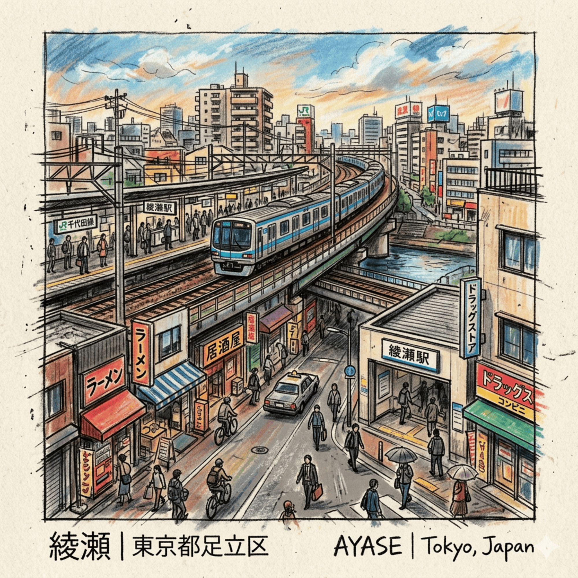
To the modern commuter, Ayase is often perceived as a mere functional node on the Chiyoda Line—a residential "bed town" of rigid concrete. However, through the lens of a cultural cartographer, Ayase reveals itself as a "Metropolitan Peripheral Ecology." Historically, this region was never a static, ancient village, but a dynamic frontier of Shinden (New Field) developments established in the low-lying marshlands of the Edo period. Engineered to absorb the capital’s systemic burdens, Ayase functioned as a vital organ of Tokyo’s anatomy, sustaining its growth through sophisticated agricultural and logistical support. The landscape is a living palimpsest; the modern geometry of urban planning struggles to mask the organic curves of ancient drainage canals and the scars of 20th-century water management. To walk Ayase is to trace the invisible support systems of old Edo, mapping a history of survival at the city’s edge.
Listen to the historical stories told in detail (For subscribers only)
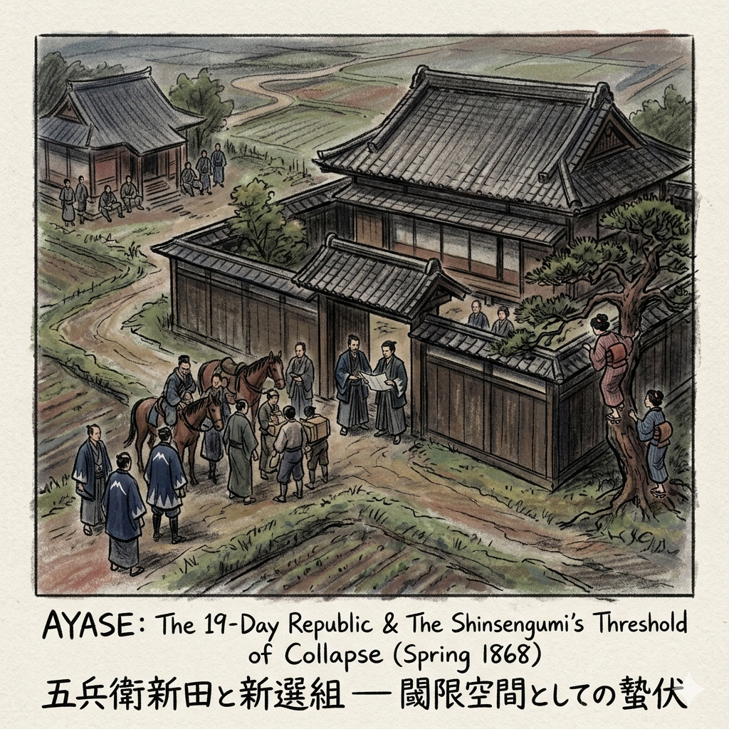
The Threshold of Collapse: Borderline Politics and the 19-Day Republic
In the spring of 1868, as the Tokugawa Shogunate neared total collapse, the village of Gohei Shinden became a "threshold space" between the dying Shogunate and the advancing Imperial forces. Following defeat at Koshu-Katsunuma, the remnants of the Shinsengumi—rechristened the Koyo Chinbutai—retreated toward Edo. Ayase provided a unique "liminal refuge" precisely because it was a shinden development, existing in a vacuum outside the direct jurisdiction of the machi-bugyo (town magistrates).
In this volatile political space, leaders Kondo Isami (under the alias Okubo Yamato) and Hijikata Toshizo (alias Naito Hayato) transformed a defeated unit of 48 into a reorganized force of 227 men. This rapid expansion placed a staggering burden on the local community. The "Oboye" records, kept by the 22-year-old family representative Kaneko Kenjuro, remain today as a micro-economic testament to the high financial price his family paid to sustain this uninvited army. Amidst this tension, the cultural record notes a curious social reality: local women, captivated by the presence of the legendary warriors, were seen climbing backyard trees to steal glimpses of Kondo and Hijikata within the estate.
The spatial legacy of this "19-Day Republic" remains anchored to the Kaneko Family Residence, whose high walls still reflect the defensive posture of a wealthy Edo-period farmstead, and Kanzeonji Temple, which served as a garrison for over 60 soldiers. This brief political residency serves as a case study in "Borderline Politics," where the periphery became the final staging ground for a collapsing regime.
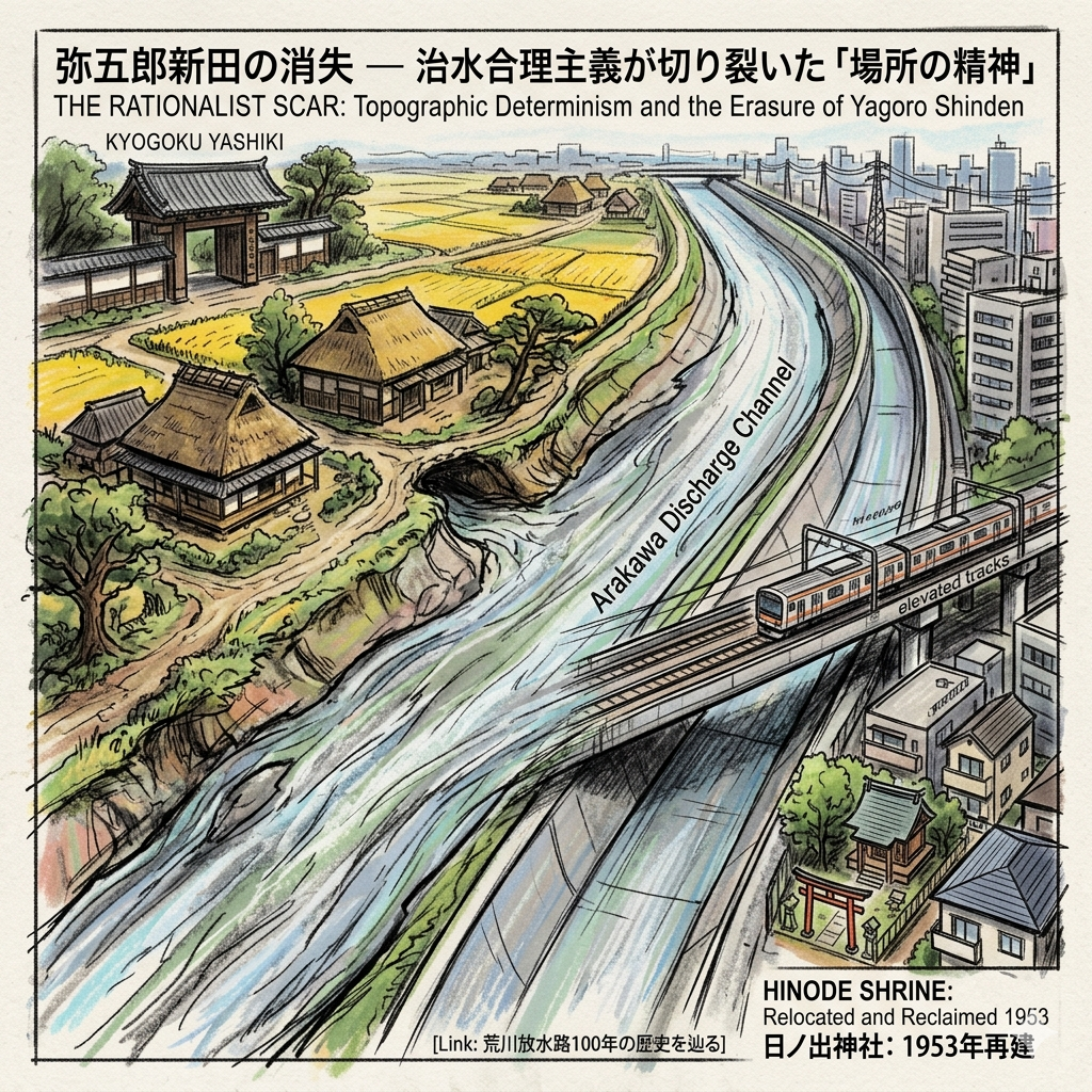
The Rationalist Scar: Topographic Determinism and the Erasure of Yagoro Shinden
The physical identity of Ayase was irrevocably shattered by the Great Flood of 1910, an event that triggered a radical state-led modernization of the landscape. To protect the economic core of central Tokyo, the Meiji government prioritized "治水" (flood control), initiating the construction of the Arakawa Discharge Channel. This 500-meter-wide artificial river was an exercise in "topographic determinism," where the survival of the metropolis necessitated the sacrifice of peripheral villages.
The project resulted in profound "cadastral fragmentation." The ancestral lands of Yagoro Shinden—pioneered centuries earlier by Kyogoku Yagoro—were physically severed. Ancient homes and fertile fields were submerged beneath the artificial riverbed. The community’s spiritual heart, the Inari Shrine, was slated for erasure. However, in an act of "micro-resistance," the community, led by figures like Otsuka Magohisa, engaged in ritual relocation. They merged their deity with a nearby shrine for safekeeping before eventually reclaiming their identity in 1953. Today, the Hinode Shrine stands defiantly in a narrow gap between modern residences and elevated tracks, a poignant symbol of the clash between national narratives and local sorrow.
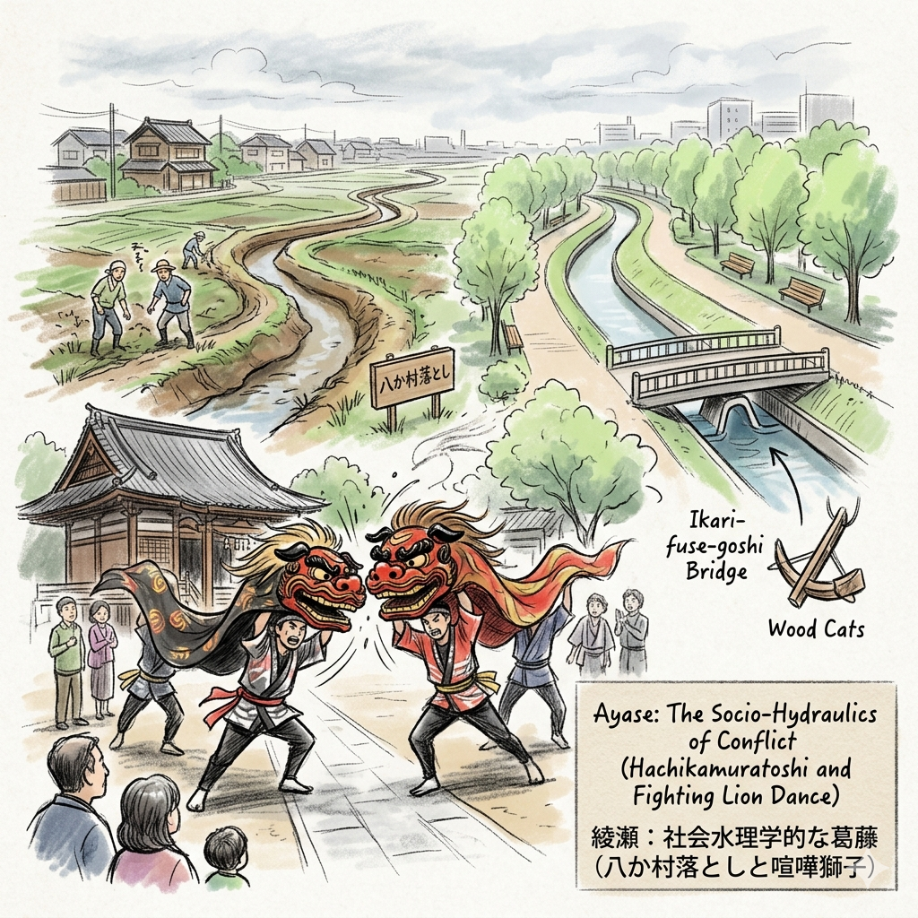
The Socio-Hydraulics of Conflict: Ritualized Drainage in a Lowland Society
Survival in Ayase’s clay-rich marshlands was dictated by the "Hachikamuratoshi" (Eight-Village Drainage), a 12-kilometer network designed to evacuate akusui (bad water) from the fields. Because this system linked eight villages with competing interests, it created a complex "socio-hydraulic" environment where maintenance and drainage rights were constant sources of friction.
This environmental tension was sublimated through folk culture. The "Kenka Shishi" (Fighting Lion) dance at Pumen-ji Temple served as a ritualized "safety valve" for these inter-village conflicts. The aggressive clashing of the lion masks represented the very real tensions between upstream and downstream farmers over labor quotas and flooding. By ritualizing this violence, the "watershed community" could maintain the cooperation necessary for their collective survival.
Today’s observer should walk the Hachikamuratoshi Water-Friendly Green Road, which preserves the meandering path of the ancient canal. Look for the "Wood Cats" (wooden anchors) and the "Ikari-fuse-goshi Bridge," which utilized inverted siphon technology to manage the flow—physical artifacts of a society that lived by the grace of its engineering.
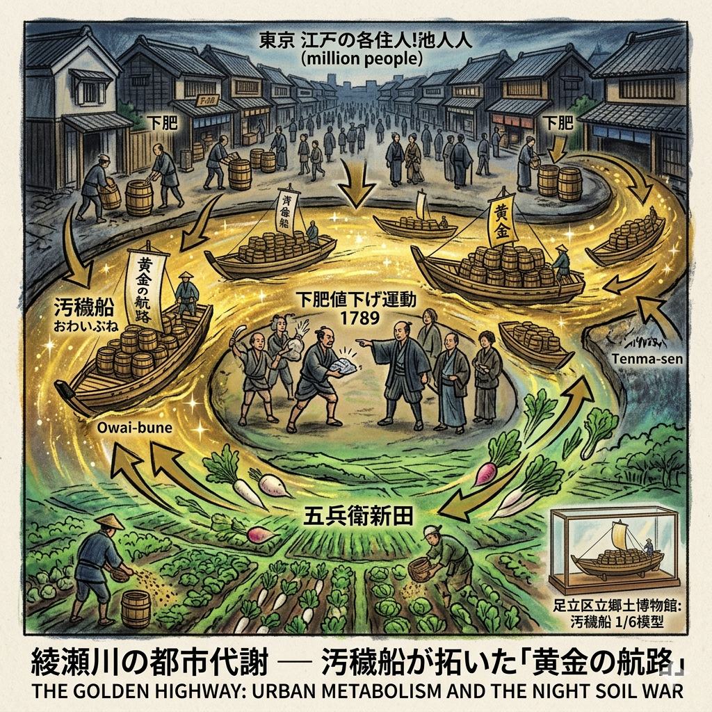
The Golden Highway: Urban Metabolism and the Night Soil War
In the 18-century, Ayase was the centerpiece of a world-leading ecological "closed-loop." While European cities struggled with sewage, Edo and its periphery functioned through a "Golden Highway" of nutrient cycling. The Ayase River was the primary artery for the Owai-bune (night soil boats), facilitating an urban metabolism where the city’s waste became the periphery's wealth.
This was not a sanitized utopia, but a hard-fought marketplace. The "Night Soil Price Reduction Movement" of 1789 saw a four-year conflict between Ayase farmers and city brokers, proving that the metabolic loop was a site of intense economic struggle. Wealthy farmers traded silver for the right to collect "night soil" (shimo-goe) from the mansions of Edo, transporting it in 22-meter Tenma-sen boats to the loading docks of Gohei Shinden. The Adachi City Museum preserves this history with 1:6 scale models of these metabolic vessels, illustrating a time when the river was an ecological corridor sustaining a million-person metropolis.
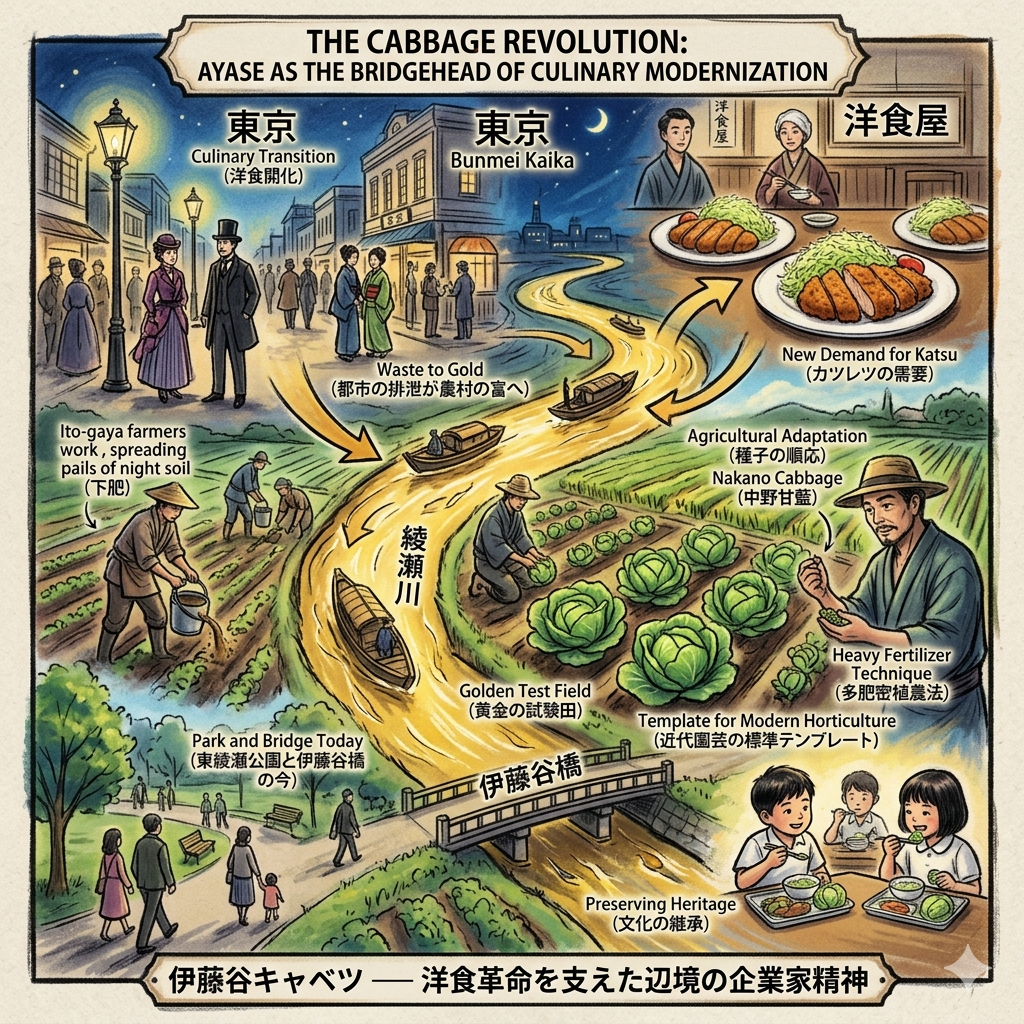
The Cabbage Revolution: Ayase as the Bridgehead of Culinary Modernization
The "Cabbage Revolution" of the late 19th century was the direct physical outcome of Ayase’s metabolic history. During the Bunmei Kaika (Civilization and Enlightenment) era, Tokyo’s burgeoning Yoshoku (Western dining) scene created a sudden demand for cabbage. However, European seeds initially failed in the Japanese climate.
The farmers of Ito-gaya proved to be brilliant agricultural entrepreneurs. Utilizing the heavy-fertilizer cultivation made possible by the "Golden Highway" of night soil, they collaborated with pioneers like Nakano Tosuke to adapt seeds. They perfected the "Nakano Cabbage," turning Ayase into the "Golden Test Field" for modern Japanese horticulture. This was the final layer of Ayase’s support for Tokyo: providing the "Standard Template" for the vegetables that would define the modern Japanese palate. The Ito-gaya Bridge and Higashi-Ayase Park now sit atop these former revolutionary fields, where capitalist enterprise once met traditional fertilization to feed a changing nation.
Hidden Gems for the Thoughtful Observer
- The Gohei Shin-hashi Bridge: Stand here to contemplate the logistical scale of the Edo period; its specific width was engineered to accommodate the maneuverability of the 22-meter Tenma-sen waste boats.
- The Pumen-ji Temple Markers: Observe the grave of Sano Ichizaemon, the 17-century pioneer whose drainage engineering allowed the "Eight-Village" system to function.
Conclusion: The Philosophical Landscape of the Periphery
The history of Ayase demonstrates that to understand Tokyo, one must look beyond the gleaming highlights of the center to the "layered observation" of the edges. Ayase was never just a suburb; it was a "Metropolitan Peripheral Ecology" that provided sanctuary, food, and waste management for a burgeoning empire.
As we traverse the modern landscape, we must ask: what modern support systems do we ignore today? The data centers and logistics hubs of our own era are the "Shinden" of the future. The modern commuter on the Chiyoda Line is merely the new "material flow," replacing the night soil and cabbage of the past. To understand this is to see the city not as a collection of buildings, but as a living, breathing system of support.
Discover more hidden layers of the city. Subscribe to our "Historical Travel Stories" newsletter.
Practicalities: Access and Continuity
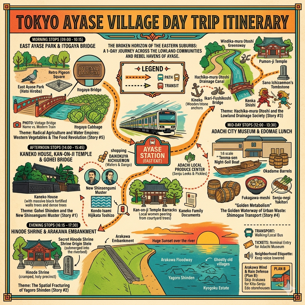
How to Experience Ayase: Take the Tokyo Metro Chiyoda Line to Ayase Station. This route is best experienced on foot. Begin at the Kaneko Family Residence (Ayase 4-chome), walk along the curves of the Hachikamuratoshi Green Road, and conclude at the Adachi City Museum to see the artifacts of the metabolic river trade.
Internal Links:
- A Guide to the History of the Arakawa River: The Price of Rationalism.
- Edo’s Agricultural Belts: From Nerima Daikon to the Ito-gaya Revolution.
Recommended Nearby: For a deep immersion into the northern "support" suburbs, consider staying in the historic Senju-shuku area, located just one stop away on the Chiyoda Line.
Q & A
How did Edo's waste system fuel the local cabbage revolution?
Edo’s waste system was the vital engine behind the "local cabbage revolution" in Ayase Village by creating a highly efficient urban-rural nutrient loop that transformed the city's biological waste into "gold fertilizer" (kinpi) for industrial-scale gardening.
The following factors illustrate how this system fueled the agricultural transformation:
1. Provision of High-Quality Nutrients for "Exotic" Crops
Western vegetables like cabbage, which became essential for "Western-style" dishes like Tonkatsu during the Meiji era, required much more intensive fertilization than traditional Japanese crops.
Because Ayase was a low-lying "shinden" (new field) area lacking forests for traditional compost materials like leaf mold or wood ash, farmers became structurally dependent on Edo's human waste, known as shimogoe. This nutrient-rich fertilizer was essential for the "intensive high-fertilizer farming method" (tahi misshoku noho) that allowed Itodani farmers to successfully grow cabbage and overcome diseases like black rot.
2. The Ayase River as a "Waste Highway"
The waste system relied on a sophisticated logistics network where the Ayase River served as the primary "golden waterway". Special waste-carrying boats (owai-bune or tenma-sen) transported human waste from the densely populated districts of Edo (such as Honjo and Fukagawa) directly to specialized landings in Ayase Village. This direct water-link ensured a steady and massive supply of fertilizer that was far more efficient than land transport, enabling the village to scale up production to meet the sudden surge in urban demand.
3. A Two-Way Economic and Ecological Loop
The revolution was fueled not just by the waste itself, but by the reciprocal trade it enabled. After unloading the shimogoe into field storage tanks, the same boats would load up with the freshly harvested "Itodani Cabbage" to sell at the Kanda and Senju markets.
This "nutrient-for-produce" exchange created a sustainable capital cycle that funded the farmers' scientific experiments and technological adaptations.
4. Overcoming Environmental Barriers
By importing Edo’s waste, Ayase farmers effectively bypassed the natural limitations of their swampy, clay-heavy soil,. The massive application of shimogoe transformed these challenging lowlands into the "bridgehead" of Japan’s vegetable gardening industry, allowing the local "Itodani Cabbage" to eventually dominate the Tokyo market and serve as the national template for cabbage cultivation.
While Western scholars often praised this as a perfect ecological circle, it was a system built on intense labor and the unique proximity of a mega-city’s waste to its agricultural fringe, making Ayase a pioneer of "tabletop capitalism".
What are some modern ways Ayase celebrates its cabbage heritage?
Today, even though most of the original farmland has been replaced by residential areas and parks, Ayase (particularly the former Itodani area) celebrates its cabbage heritage through community events, educational programs, and local landmarks.
The modern celebrations of this "cabbage revolution" include:
- The Ayase Village & Cabbage Festival: The local community and agricultural cooperatives periodically hold the "Ayase Village Birth Memorial and Shinsengumi/Itodani Cabbage Festival". This event typically takes place at the "Hato Plaza" (Pigeon Plaza) in Higashi-Ayase Park, located near the east exit of Ayase Station.
- Distribution of "Revived" Cabbage: During these festivals, the community works to distribute revived Itodani cabbage to local citizens. This allows residents to taste the specific variety that once dominated Tokyo's markets during the Meiji and Taisho eras,.
- Integration into School Lunches: The legacy of the cabbage revolution is passed down to younger generations through the local school meal (給食, kyushoku) system,. Elementary and middle schools in the area recreate the flavors of the "century-old famous dish" to educate students about their neighborhood's role in Japan's culinary modernization.
- Geographic Landmarks: The Itodani Bridge, which connects Ayase 1-chome and Nishi-Ayase, serves as a permanent modern reminder of the "Itodani" name and the legendary fields that once occupied that space.
- Educational Displays: The Adachi City Museum (Adachi-ku ritsu Kyōdo Hakubutsukan) maintains records and displays related to the "Itodani Cabbage" and the agricultural history of the region, helping to preserve the historical context of how these vegetables were grown using the city's recycled waste,.
These efforts transform what could be seen as a standard urban greenway or residential zone into a "historical palimpsest," where the memory of the "bridgehead of the Western vegetable revolution" remains a part of daily life.
Reference and Further reading
- 綾瀬村 - accessed May 21, 2026,
- 市制40周年特別企画 綾瀬誕生130年の歴史辿る 「がんばる市内企業」を紹介 - タウンニュース, accessed May 21, 2026,
- 2009年 『綾瀬村誕生120周年と新選組』 イベント情報, accessed May 21, 2026,
- 綾瀬川の歴史・文化 | 江戸川河川事務所 - 関東地方整備局, accessed May 21, 2026,
- 知っていますか?荒川放水路のこと「荒川放水路通水100周年」 - 足立区, accessed May 21, 2026,
- 金子家 | あだち観光ネット, accessed May 21, 2026,
- 金 子 家 文 書 - 足立区, accessed May 21, 2026,
- 新撰組 - むーやんのてげてげ散歩, accessed May 21, 2026,
- フォト散歩 綾瀬駅周辺~新撰組ゆかりの地を訪ねて - kenのデジカメライフ, accessed May 21, 2026,
- 五兵衛新田 - 歴旅.こむ, accessed May 21, 2026,
- 綾瀬・流山記3 金子家・五兵衛橋 | 新選組 徒然日記, accessed May 21, 2026,
- 日ノ出神社(足立区日ノ出町)|散歩日記, accessed May 21, 2026,
- 弥五郎新田(やごろうしんでん)とは? 意味や使い方 - コトバンク, accessed May 21, 2026,
- 上野下野道の記-初日, accessed May 21, 2026,
- 【歩き旅】水戸街道 Day1 〜下町をゆく - 歴史と散歩とポタリングと, accessed May 21, 2026,
- 歴史の浪漫街道/ 祭りだ!神輿だ!お江戸の神輿 H27年 北千住 日之出神社, accessed May 21, 2026,
- 江戸史蹟散歩 八か村落とし, accessed May 21, 2026,
- 冬の水辺散歩・八か村落とし親水緑道から東綾瀬公園を歩く 東京都足立区 - 高速バス, accessed May 21, 2026,
- 都市近郊農村の下肥利用 - 日本下水文化研究会 定例研究会, accessed May 21, 2026,
- 特別展「肥やしの底チカラ」 | 展示 | 葛飾区郷土と天文の博物館|Katsushika City Museum, accessed May 21, 2026,
- 都市近郊における下肥の利用, accessed May 21, 2026,
- 郷土博物館 | あだち観光ネット, accessed May 21, 2026,
- 葛飾から全国に広まった細田生まれの春キャベツ「中野甘藍・なかのかんらん」を学ぼう [葛飾区立細田小学校3年生] | 【潜入!】『まいぷれ葛飾』編集部が行く!, accessed May 21, 2026,
- エリアデザイン調査特別委員会 報告資料, accessed May 21, 2026,
- ほほえみ 2025年夏号 - JA東京スマイル, accessed May 21, 2026,
- 【あだちミステリーハンター】新選組・近藤勇の最期の19日間。 〜綾瀬に想う 時代に翻弄された男の人生, accessed May 21, 2026,
- Blog Archive » 江戸時代の足立区 地域を守っていた郷士の名家 郷土博物館で特別展開催中, accessed May 21, 2026,
- 綾瀬稲荷神社 | 東京都足立区 - 古今御朱印研究所, accessed May 21, 2026,
- 新選組とあだち - 足立区, accessed May 21, 2026,
- 秋期企画展「荒川放水路通水100周年記念展示 東京をまもった人工水路と生きものたち」, accessed May 21, 2026,
- 荒川放水路変遷誌 - 関東地方整備局, accessed May 21, 2026,
- 中川流域の治水史, accessed May 21, 2026,
- 綾瀬北野神社|足立区綾瀬の神社 - 猫の足あと, accessed May 21, 2026,
- 今日は水路を辿って散歩してみた - 清く正しくたくましく, accessed May 21, 2026,
- 江戸時代の土木遺産:「見沼代用水」と「見沼通船堀」 (みぬま だいようすい)と(みぬま つうせんぼり), accessed May 21, 2026,
- 1 1.綾瀬川流域の概要 1.1 流域の変遷 江戸時代以前の綾瀬川は、荒川からの水の流れが大きく, accessed May 21, 2026,
- 【綾瀬川】人の営みのそばで、姿を変えてきた川 | SAITAMAリバーサポーターズ, accessed May 21, 2026,
- 海洋総合辞典Comrehensive Ocean Dictionary, 一枚の特選フォト「海 & 船」Ocean and Ship Photos, 伝馬船、埼玉県八潮市立資料館, accessed May 21, 2026,
- 江戸の暮らしを支えた葛飾の農作物 - 葛飾区史|第2章 葛飾の歴史, accessed May 21, 2026