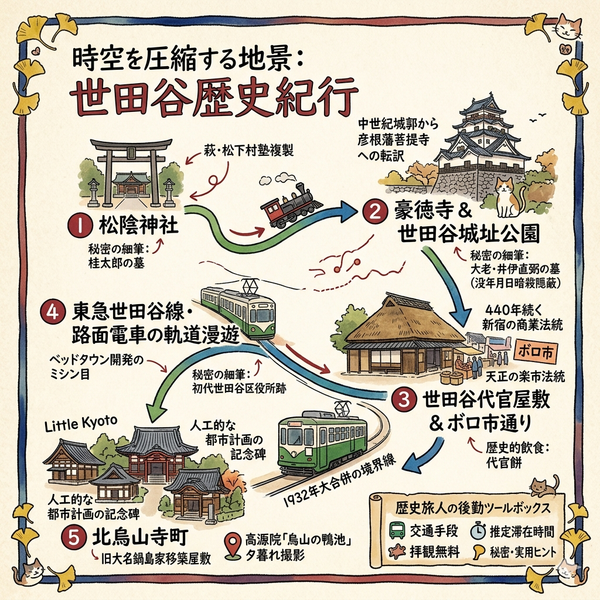
(ENG) Mizue Heritage Walk – Discovering the Liquid History and Hidden Landscapes of Eastern Tokyo
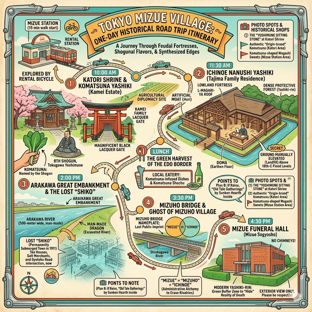
Step into Mizue, where Tokyo's "liquid history" unfolds. This guide takes you through the defensive moats of Ichinoe Nanushi Yashiki, the origins of Komatsuna at Katori Shrine, and the vanished landscapes submerged beneath the Arakawa Floodway.

This is a historical travel story and walking guide to Mizue, a unique neighborhood in Edogawa, Tokyo. By exploring sites like the Ichinoe Nanushi Yashiki and the Arakawa Floodway, it reveals how this low-lying area transformed from a defensive feudal village into a vital, yet invisible, functional edge of the modern metropolis. Readers will discover the intersection of water management, shogunal legends, and urban evolution through a curated walking route.
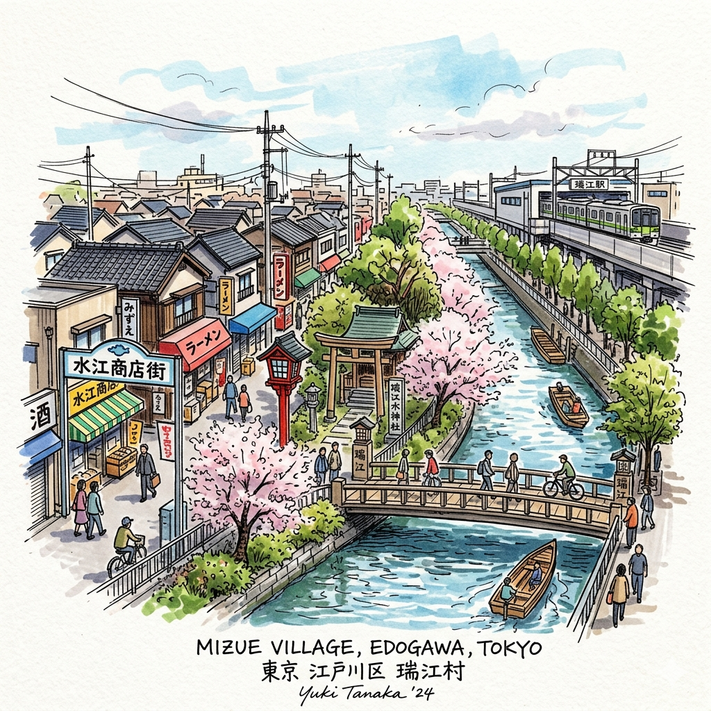
To the modern commuter arriving via the Toei Shinjuku Line, Mizue presents the face of a standard residential suburb. However, for the cultural historian, this neighborhood is a profound testament to "liquid history"—a landscape defined not by static boundaries, but by the relentless conquest of wetlands and the strategic manufacturing of identity. Mizue represents the "functional edge" of Tokyo, a peripheral zone that has historically served the capital’s most fundamental needs: food production, flood protection, and the management of urban hygiene.
In serving these roles, the area’s original landscape was largely sacrificed, replaced by an "artificial dragon" of canals and administrative constructs. To walk through Mizue today is to observe five distinct historical layers where feudal defense, hydraulic modernity, and urban ethics collide. The very name "Mizue" serves as our first clue, signaling a transition from organic village life to a managed urban threshold.
Listen to the historical stories told in detail (For subscribers only)
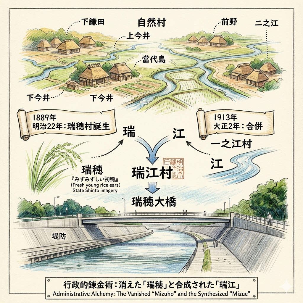
The Administrative Alchemy: How "Mizuho" and "Ichinoe" Became One
The naming of a village is rarely a poetic accident; in Japan’s path to modernization, it was a deliberate political act. During the late 19th century, the Meiji government sought to consolidate power through the "Meiji Great Merger" of 1889. In this process, six ancient natural villages—Shimokamata, Kami-imai, Shimo-imai, Toudaijima, Maeno, and Ninoe—were dissolved and reconstituted as "Mizuho."
This shift replaced blood-based ritual boundaries and centuries-old hamlet identities with a "synthetic toponym." By 1913, Mizuho merged with Ichinoe to create the current "Mizue." This administrative alchemy used the symbols for "Rice" (Mizu) and "River" (E) to create a functional collective identity, effectively erasing the organic map of the lowlands in favor of state efficiency.
"Mizuho" refers to "Mizumizushii hatsuho" (fresh young rice ears). This was not merely a description of the vast paddy fields, but a projection of the "Land of Fresh Rice Ears" imagery central to State Shinto ideology.
Today, the Mizuho-Ohashi Bridge stands as the last physical remnant of this vanished identity. As you cross it, observe the significant height of the embankments; they are a physical manifestation of the hydraulic pressure that necessitated such administrative unity and engineering resolve.
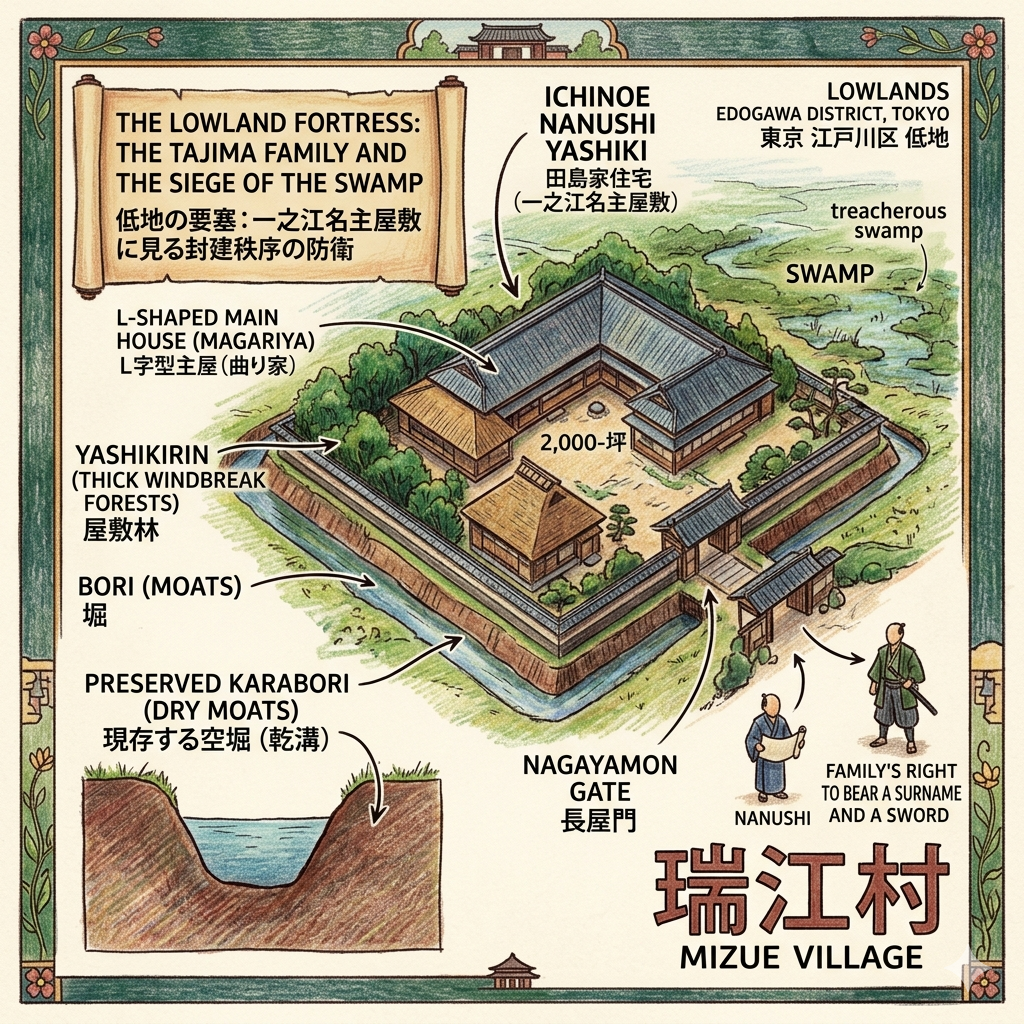
The Lowland Fortress: The Tajima Family and the Siege of the Swamp
In the Edo period, surviving the alluvial plain required a defensive mindset. The Nanushi (village head) acted as the critical bridge between the Shogunate and the peasantry, overseeing the reclamation of what was then a treacherous swamp. The Ichinoe Nanushi Yashiki, the 2,000-坪 estate of the Tajima family, is a rare surviving example of a "lowland fortress" designed for this environment.
The estate reflects the architectural nuance of a "Medieval Warrior/Squire" (中世土豪) style defense. Its L-shaped main house (magariya) is protected by bori (moats) and yashikirin (thick windbreak forests), configurations born from a deep insecurity regarding both floodwaters and social unrest. This was a seat of power where the nagayamon gate signaled the family’s right to bear a surname and a sword. Standing by the preserved karabori (dry moats) today, one gains a rare glimpse into a 17th-century world where the environment was as much a strategic enemy as it was a provider.
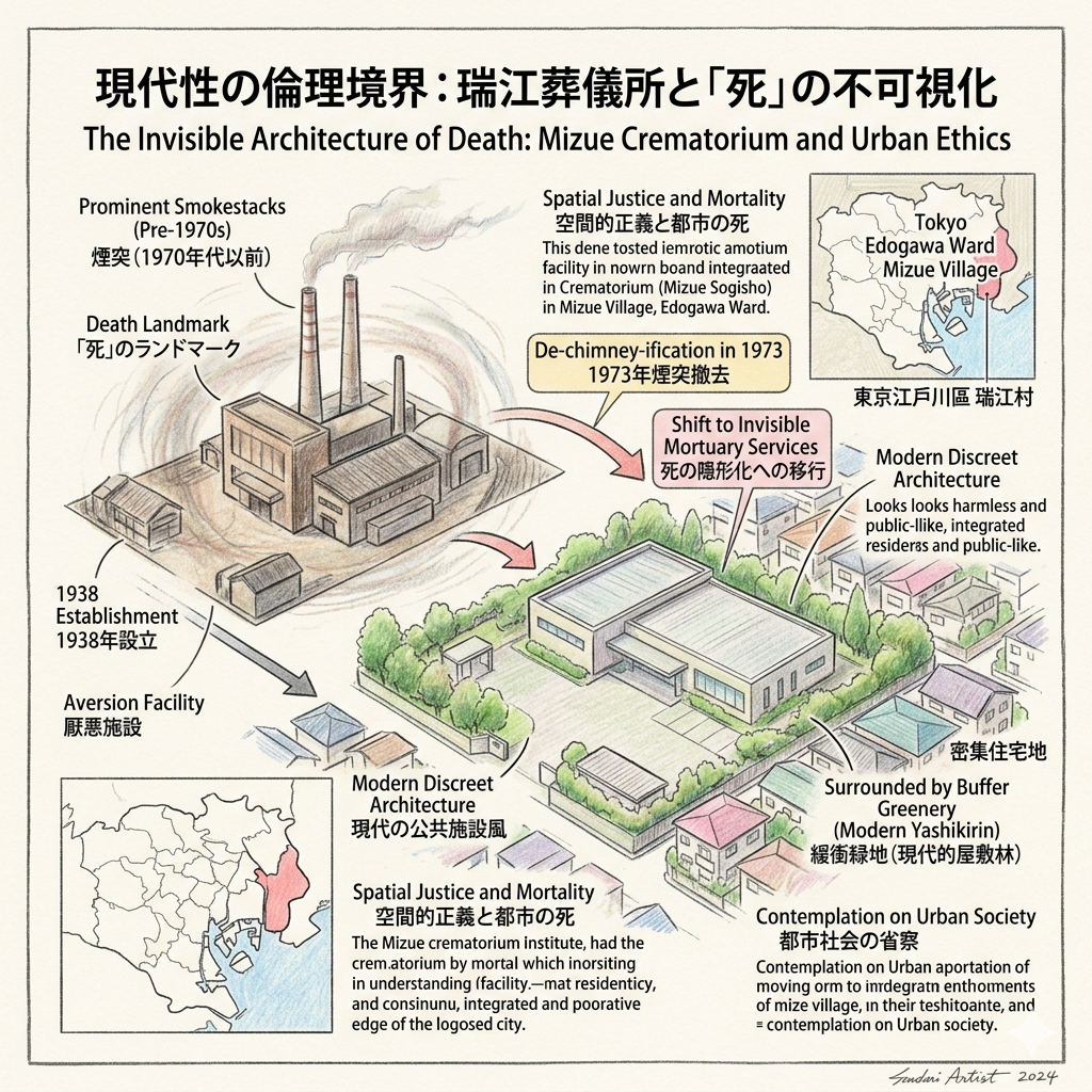
The Invisible Architecture of Death: Mizue Crematorium and Urban Ethics
As Tokyo’s population exploded in the early 20th century, the city’s peripheral zones were designated for "aversion facilities"—the necessary but unwanted infrastructures of urban life. In 1938, the Mizue Crematorium (Mizue Sogisho) was established as the city’s largest public facility. Its presence here is a case study in "spatial justice," where the edge of the city carries the weight of the center’s mortality.
The history of this site reflects a shift toward "Symbiotic Aversion." Originally a "death landmark" defined by prominent smokestacks, the facility underwent a radical "de-chimney-ification" in 1973. Modern automated technology allowed the facility to become invisible, adopting a discreet, office-like architectural style. Today, surrounded by buffer greenery that serves as a modern interpretation of the traditional yashikirin, the facility coexists within a dense residential neighborhood—a site that demands contemplation on how society rationalizes and distances itself from the end of life.
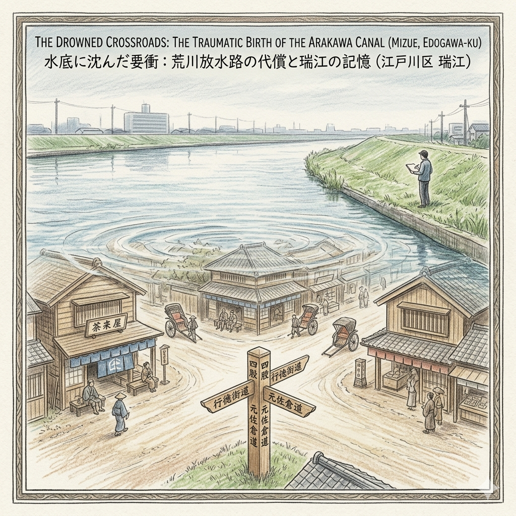
The Drowned Crossroads: The Traumatic Birth of the Arakawa Canal
The modern geography of Mizue was forged in the trauma of the 1910 "Great Flood of Geng-Xu." The disaster was catastrophic: in Edogawa-ku alone, there were 62,000 victims and 3,654 households affected. The government’s response was a massive feat of "Hydraulic Modernity"—the excavation of the 20km man-made Arakawa Drainage Canal.
This "artificial dragon" required a profound functional sacrifice. To protect the Imperial Palace and central Tokyo, the bustling "Shiko" crossroads—once a vibrant hub of tea houses at the intersection of the Gyotoku Salt Road and the Moto-Sakura Road—was completely submerged. More than 1,300 homes and ancient temples were relocated to make way for the trench. Standing on the Arakawa levee today, one must visualize the lost world beneath the water; the canal effectively transformed Mizue from a historical gateway into an isolated peripheral zone.
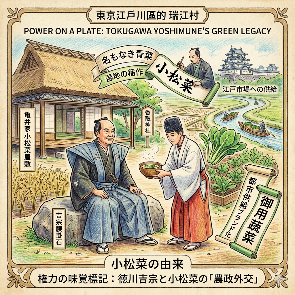
Power on a Plate: Tokugawa Yoshimune’s Green Legacy
While much of Mizue’s history is defined by struggle, one legacy flourished through "agrarian diplomacy." During an 18th-century visit to the local Katori Shrine, Shogun Tokugawa Yoshimune was served a soup containing a local, unnamed green. Impressed, he named the vegetable Komatsuna after the nearby Komatsugawa district.
This naming ceremony was a masterstroke of political branding, transforming a local weed into a "shogunal brand." It shifted the local economy from a simple rice-producing wetland into a high-value vegetable garden for the Edo market. The "Komatsuna Yashiki" (the Kamei family estate) still holds the "Yoshimune Sitting Stone," a physical anchor for this moment of historical encounter. Even today, Edogawa-ku remains a primary producer of the vegetable, proving how a Shogun’s whim can shape a region’s economic identity for three centuries.
Hidden Gems for the Thoughtful Traveler
For those seeking to touch the spiritual roots of this region, the Katori Shrine and its Komatsuna Ubusunagami stone is an essential stop. This site serves as a bridge between the Shogunal legends of the 1700s and the modern local identity of the farmers who still pray here for a bountiful harvest, representing the "Semiotic Layering" that defines the neighborhood.
Conclusion: The Layered Observation of the Edge
The history of Mizue is a complex synthesis of adaptation and management. It is a place where the city has repeatedly decided which parts of its past are worth preserving in stone and which must be sacrificed to the river to ensure the survival of the metropolis.
Mizue stands as a reminder that the "edge" of a city is often its most revealing threshold. It is where the mechanics of survival—food, safety, and the management of death—are most visible to those who know where to look. To observe Mizue is to see Tokyo not as a static entity, but as a space in perpetual flux.
To explore more of Tokyo's forgotten thresholds, subscribe to our historical dispatches.
Travel Logistics
- How to Get There: Access Mizue Station via the Toei Shinjuku Line, approximately 30 minutes from central Tokyo.
- Recommended Tour: A walking route starting at Mizue Station, moving to the Mizuho-Ohashi Bridge to observe the embankments, continuing to the Ichinoe Nanushi Yashiki, and concluding at the Arakawa Levee to visualize the submerged Shiko crossroads.
- Accommodation Tip: For those exploring the historic eastern districts, consider staying near Kinshicho for easy transit access to the peripheral historic wards.
Q & A
How did the 1910 Great Flood reshape Tokyo's landscape?
The 1910 Great Flood, known as the Koushu Great Water Disaster, caused the embankments of the Tone and Arakawa Rivers to collapse, leaving the entire southern Minami-Katsushika district—including modern-day Edogawa—underwater. This catastrophe served as the direct catalyst for the Japanese government to implement a radical engineering project: the excavation of the Arakawa Discharge Channel (Arakawa Housuiro).The resulting landscape changes were profound and permanent:
- Creation of a "Man-made Giant Dragon": The government carved out an artificial waterway 20 kilometers long and 500 meters wide. This was not a natural river but a massive engineering feat that physically severed the landscape.
- Mass Relocation and Destruction: To make way for the channel, approximately 1,300 households were forced to move. This process involved the "spatial displacement" of entire communities, including the relocation of centuries-old temples and cemeteries.
- Submergence of Historical Hubs: The flood and subsequent construction led to the permanent loss of "Shiko" (Four-Way), a bustling historical intersection of the Gyotoku and Moto-Sakura roads. This former commercial hub, once filled with teahouses and travelers, now lies forever at the bottom of the Arakawa River.
- Geographic Isolation: The excavation transformed regions like Mizue from inland transportation gateways into "island-like peripheries". By cutting these areas off from central Tokyo with a massive artificial barrier, the project redefined them as "isolated buffers".
- The Rise of Hydraulic Modernity: The landscape was reshaped into a modern flood defense laboratory. The traditional low-lying marshlands were replaced by a complex network of modern sluice gates and drainage systems designed to protect the urban core.
- Hierarchical Urban Defense: The project reflected a "logic of hierarchical defense," where the eastern lowlands (like Mizue and Komatsugawa) were strategically sacrificed to serve as a functional buffer to protect Tokyo’s central core, including the Imperial Palace and the Honjo and Fukagawa districts.
This transformation marked a shift toward "Environmental Domination," where natural water systems were replaced by an "artificial political project" to ensure the survival of the metropolis.Would you like me to create a tailored report or a slide deck to further illustrate the geographic evolution of Tokyo's eastern districts following this flood?
How did the name Mizue originate from local village politics?
The name Mizue originated not from a natural geographical feature, but from a calculated "administrative alchemy" designed to resolve local political tensions during the consolidation of villages in the early 20th century,.According to the sources, the origin of the name can be broken down into the following political and symbolic stages:
1. The Precursor: Mizuho Village (1889)
Following the Meiji government’s nationwide "Great Merger of Towns and Villages" (1889) to increase administrative efficiency, six historic natural villages (including Shimokamata and Ninoe) were merged into a single entity called Mizuho Village. The name "Mizuho" (meaning "fresh ears of rice") was chosen to project the nationalistic image of Japan as the "Land of Fresh Ears of Rice" and to describe the local landscape of vast paddy fields.
2. The Political Compromise (1913)
In 1913 (Taisho 2), further administrative needs—specifically the shared maintenance of water facilities—led to the merger of Mizuho Village and Ichinoe Village. This merger created a political challenge: how to combine the two entities without wounding the "geographical self-esteem" of either community.To balance these local interests, officials utilized a "synthetic place name" (gosei chimei) strategy, which was common in Japan at the time:
- "Mizu" (瑞): Taken from Mizuho Village, representing the sanctity and abundance of the rice harvest.
- "E" (江): Taken from Ichinoe Village, directly referencing the area’s geographical nature as a place of crisscrossing rivers and complex canal systems.
3. Significance of the Name
While modern residents often assume the name "Mizue" refers to the natural beauty of the rivers or wetlands, the sources clarify that it is a pure administrative product. This naming was a deliberate tool of the modern state used to:
- Dissolve traditional conflicts: By taking a piece of each village's name, the new title served to neutralize regional rivalries.
- Erase old boundaries: The synthesis helped transition residents from their centuries-old identities (based on bloodlines or local shrines) into a new, unified identity as "Mizue people" focused on efficient public management,.
- Establish a functional identity: The new name laid the fiscal and organizational groundwork for the unified irrigation and water management systems that would define the region throughout the 20th century.
Today, while the administrative entity of "Mizuho" has largely disappeared, its legacy lives on in the first character of Mizue and the physical landmark of the Mizuho Bridge over the Shin-Nakagawa River.
Reference and Further reading
- 東部地区の紹介 - 江戸川区, accessed April 15, 2026,
- 江戸川区「瑞江」の名前の由来・歴史 - 金井たかし(カナイタカシ) - 選挙ドットコム, accessed April 15, 2026,
- 瑞江 - accessed April 15, 2026,
- 躍進した町 瑞江 - 雅万歩, accessed April 15, 2026,
- 一之江名主屋敷 / 資料館 / 春江町 / 瑞江駅 - 江戸川区時間, accessed April 15, 2026,
- 一之江名主屋敷 - 文化財・史跡 - 江戸川区, accessed April 15, 2026,
- 一之江名主屋敷の紹介 江戸川区 文化財・史跡, accessed April 15, 2026,
- 一之江名主屋敷, accessed April 15, 2026,
- 【指定文化財】旧鈴木家住宅とは - 厳美市民センター, accessed April 15, 2026,
- 江戸川区 水との闘いの歴史 明治~昭和 - 江戸川フォトライブラリー, accessed April 15, 2026,
- 瑞江葬儀所 - accessed April 15, 2026,
- 瑞江葬儀所のあらまし, accessed April 15, 2026,
- 瑞江葬儀所の煙やにおいの改善と地域の共生を考える!, accessed April 15, 2026,
- 瑞江葬儀所について思うこと - 神尾 てるあき Official Site, accessed April 15, 2026,
- 明治43年の大水害(1910年8月11日) - Yahoo!天気, accessed April 15, 2026,
- =2023= of 地理の会 ホームページ, accessed April 15, 2026,
- メディアに見る明治43年の東京大水害 - あらかわ学会, accessed April 15, 2026,
- 東京・江戸川区生まれの野菜、小松菜のゆかりの地を訪問しました!, accessed April 15, 2026,
- 東京都江戸川区の江戸東京野菜「小松菜」1-小松菜発祥の地 ..., accessed April 15, 2026,
- 新小岩厄除香取神社と小松菜屋敷は地域の歴史を伝える名所 - Nakayama is a small area between Narita And Haneda Airport, accessed April 15, 2026