(ENG) Mizumoto: Walking the Liquid Borders of Tokyo’s Great Water Fortress
Mizumoto Park is more than just a scenic escape; it is a "spatial laboratory" where human will and natural forces collide. This guide uncovers the park’s transformation from the 18th-century Kyōhō reforms to its role as a wartime air-defense belt, revealing the hidden layers of Tokyo’s survival.

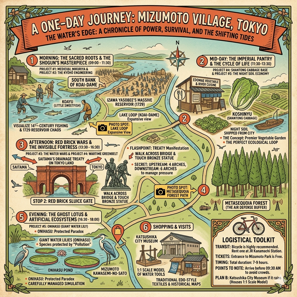
This is a historical travel story and walking guide to Mizumoto Park, Tokyo’s unique "waterfront laboratory" on the edge of the Tone River. Through layers of landscape archaeology, it explores how this unstable wetland transformed from a medieval sacred site to an Edo-period flood control fortress and a wartime air-defense greenbelt. Readers will discover the hidden power dynamics and engineering history behind one of Tokyo’s most scenic aquatic parks.

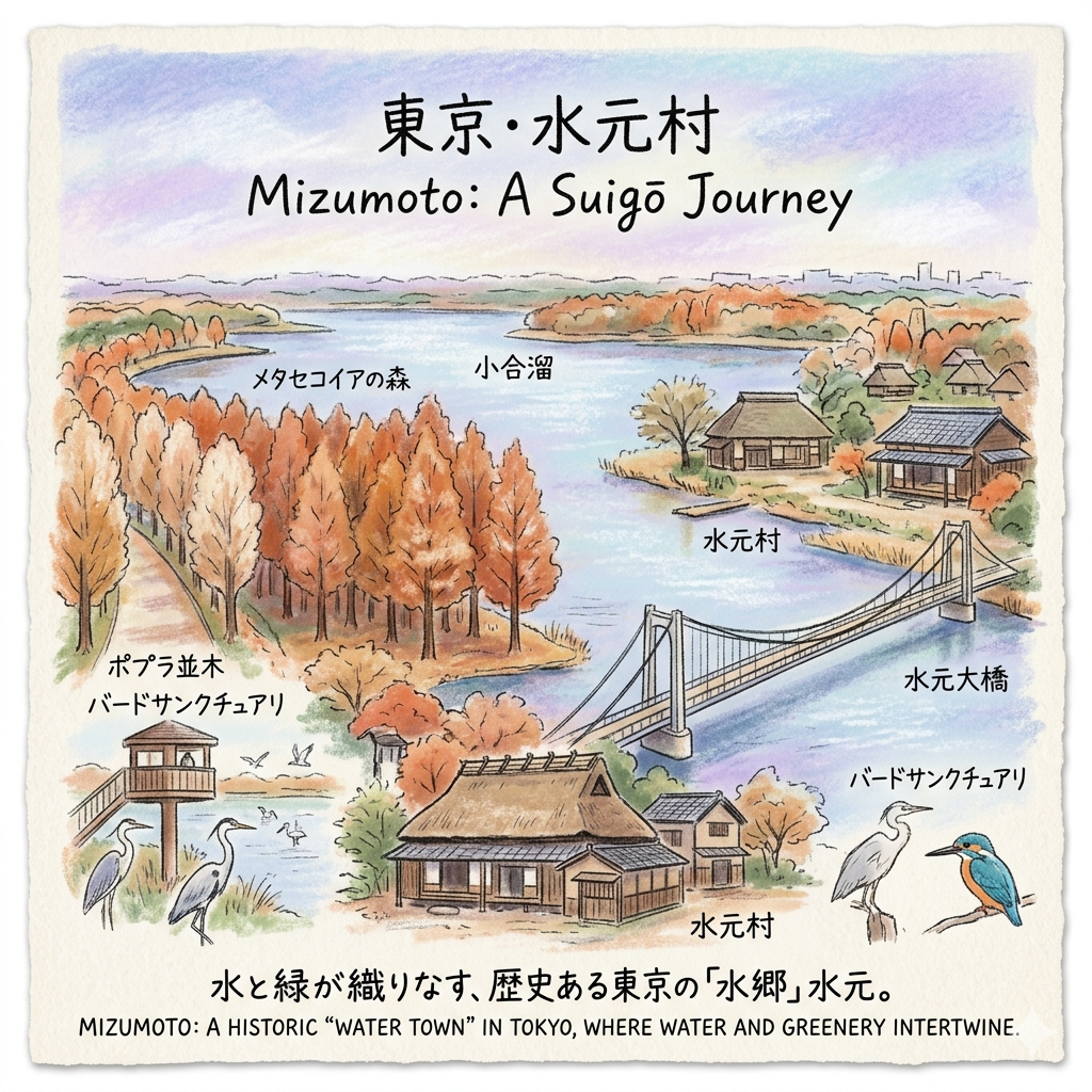
Located at the northeastern fringe of the Tokyo metropolis, Mizumoto rests at the precarious confluence of the Naka and Edo rivers. To the modern visitor, the expansive greenery and still waters suggest a park built for leisure; however, the historian recognizes a far more rigid reality. This is a landscape of "solidified" boundaries, a physical record of human willpower imposing order upon a low-lying marshland that was once an erratic, liquid frontier. Mizumoto was never intended as a retreat from the city; it was constructed as the city’s armor. To walk its paths is to traverse a hydraulic palimpsest where medieval sacred geography, Edo-period engineering, and wartime mobilization are layered one atop the other. We find here not nature in its raw state, but a controlled environment—a grand, aqueous fortress whose existence remains a testament to Tokyo’s eternal, existential negotiation with the river.
Listen to the historical stories told in detail (For subscribers only)
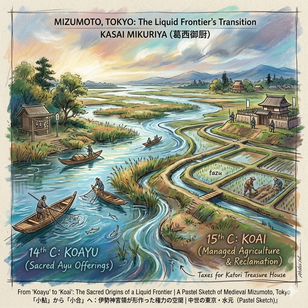
From "Koayu" to "Koai": The Sacred Origins of a Liquid Frontier
In the medieval era, the management of Japan’s floodplains was not merely a matter of civil engineering but of sacred administration. The transition of Mizumoto from a zone of natural resource extraction to a managed agricultural territory represents the first layer of human order placed upon this unstable terrain.
The Sacred Economy of Fish and Land
During the 14th century, this region was documented as Koayu (meaning "small ayu fish"). The name suggests a society defined by the river’s natural rhythm rather than the control of its flow. This area was part of the Kasai Mikuriya, a private estate dedicated to the Ise Grand Shrine. As a Mikuriya ("God’s Kitchen"), the land’s primary purpose was to provide Shinsen (sacred offerings), establishing a direct link between this remote marshland and the spiritual center of Japan.
The Shift to "Koai"
By the 15th century, the name shifted to Koai ("small junction"). This was more than a phonetic drift; it signaled a transformation in production. As the Kasai clan and other local warrior groups exerted influence, the fragmented wetlands were reclaimed for agriculture. The village evolved from a seasonal fishing site into a permanent administrative unit.
"In the record Kasai Mikuriya Tazu Chumon (1398), the acreage of villages such as Sarumata, Koayu, and Kanamachi was meticulously detailed. These records reveal that the taxes and labor from this region were specifically earmarked for the repair and construction of the Katori Grand Shrine’s treasure house, weaving the local landscape into a grander, sacred economy."
This medieval period marked the first instance of human willpower imposing order on the Tone River’s floodplain. What began as a "God’s Kitchen" provided the foundational administrative structure that the Tokugawa Shogunate would later exploit for grander engineering feats.
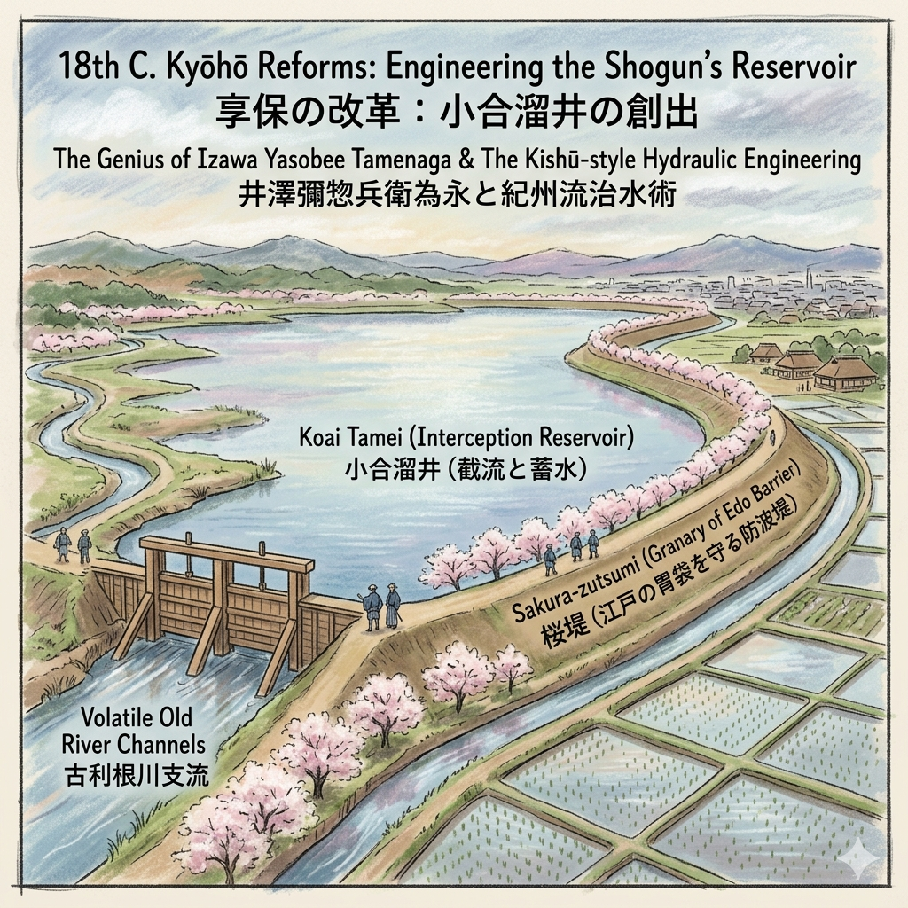
Engineering the Shogun’s Reservoir: The Genius of Izawa Yasobee
The 18th century brought the Kyōhō Reforms under the Shogun Tokugawa Yoshimune. For the Shogunate, water management was the primary pillar of financial stability; controlling the floods meant securing the rice tax. To achieve this, Yoshimune turned to Izawa Yasobee Tamenaga, a master of the "Kishū-style" of hydraulic engineering.
The Creation of Koai Tamei
In 1729, Izawa executed a radical intervention. He dammed the old river channels where the ancient Tone River once flowed, creating the Koai Tamei (Koai Reservoir). This was a sophisticated "interception and storage" strategy. By blocking the inlets and outlets of natural river branches, Izawa transformed a volatile, free-flowing waterway into an intentionally "stagnant" reservoir. This captured water provided a steady irrigation supply to thousands of hectares of new rice fields downstream, fueling the growth of Edo.
The Sakura-zutsumi: A Life-and-Death Barrier
The Sakura-zutsumi levee, now celebrated for its blossoms, was originally a grim necessity. It served as a massive earthwork barrier separating the "safe cultivation zone" from the "dangerous flood zone." This engineering turned the Katsushika area into the essential "granary of Edo."
Feature | The Erratic Frontier (Pre-1729) | The Shogunate’s Grid (Kishū-style) |
Water Flow | Free-flowing, erratic river branches | "Intercepted" stagnant reservoir (Koai Tamei) |
Land Use | Unstable floodplains and marshland | Reclaimed rice fields (New fields development) |
Flood Risk | High; constant threat from backflow | Mitigated by the Sakura-zutsumi levee |
Primary Function | Natural resource (fishing) | Systematic irrigation and food production |
By moving from physical containment to resource management, the Shogunate redefined Mizumoto as a vital utility in the urban machinery of the capital.
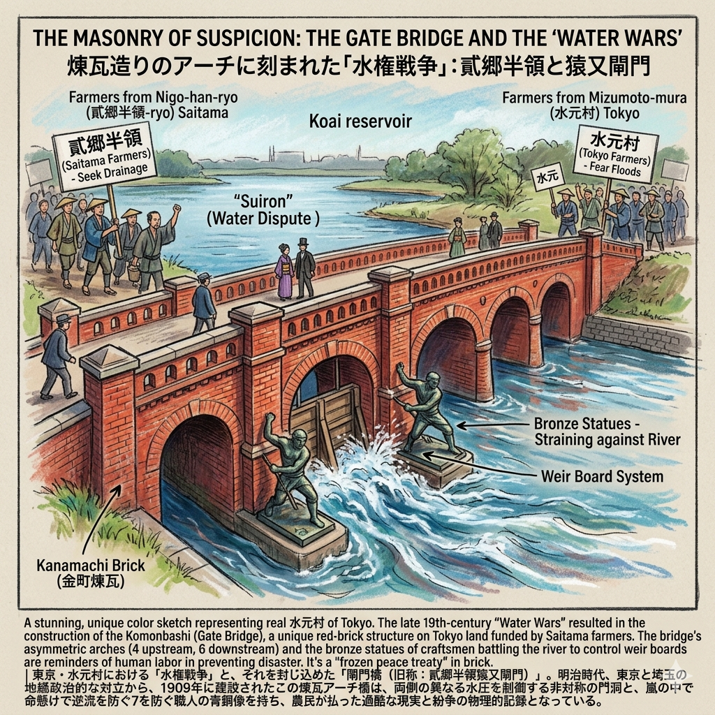
The Masonry of Suspicion: The Gate Bridge and the "Water Wars"
As the Meiji era modernized administrative boundaries, the fluid nature of Mizumoto’s water system became a source of political friction. While the village was officially part of Tokyo, its drainage was inextricably linked to the Nigo-han-ryo farmers of neighboring Saitama.
The Architecture of Conflict
In the late 19th century, water rights were a matter of survival, leading to frequent Suiron (water disputes). Farmers in Saitama needed to drain excess rainwater into the Koai reservoir, while Tokyo farmers feared the resulting floods. The solution was the 1909 construction of the Komonbashi (Gate Bridge), a stunning red-brick structure that serves as a "frozen peace treaty" in brick.
The Irony of the Komonbashi
The bridge represents a fascinating geopolitical irony: it was funded and built by the Nigo-han-ryo farmers of Saitama, yet it sits on Tokyo’s land. This was an act of defensive engineering by an external group to ensure their own drainage rights. The bridge’s asymmetric arches—four on the upstream side and six on the downstream—reflect the uneven water pressures of the two regions. At the bridge feet, bronze statues of craftsmen strain against the river, their muscles taut as they insert weir boards. This visceral imagery serves as a gritty reminder of the human labor required to prevent disaster during storms.
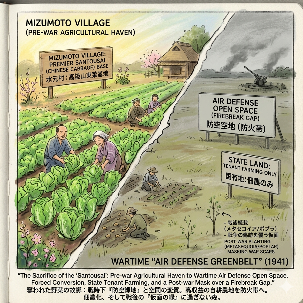
The Sacrifice of the "Santousai": From Vegetables to Air Defense
By 1940, the peaceful agricultural identity of Mizumoto was shattered by total war mobilization. During the Kigyo 2600 (Imperial Year 2600) celebrations, the government initiated a "Greenbelt Plan" that masked a darker military purpose.
The Violence of Spatial Transition
Before the war, Mizumoto was Tokyo's premier vegetable hub, famous for high-end Santousai (Chinese cabbage) that supplied the markets of Kanda. In 1941, this "stomach of Tokyo" was forcibly converted into an Air Defense Open Space. This transition was a form of spatial violence; farmers were stripped of their autonomy and turned into tenant farmers on state land, forced to grow military rations on soil that was now designated as a firebreak. The wide, open lawns where families now picnic were originally designed as massive fire gaps and refugee centers, intended to protect the imperial center from aerial bombardment.
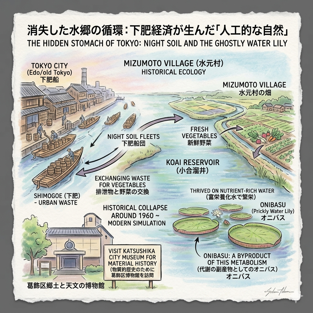
The Hidden Stomach of Tokyo: Night Soil and the Ghostly Water Lily
The final layer of Mizumoto’s history is found in the pre-chemical "circular economy." The fertility of these fields depended on Shimogoe (night soil)—the human waste of Tokyo’s urban population.
The Metabolic Cycle
Daily fleets of boats traveled from the city’s canals to Mizumoto, exchanging urban waste for fresh vegetables. This nutrient-rich water created an artificial habitat in the Koai reservoir, allowing the Onibasu (Prickly Water Lily), now a natural monument, to thrive. The Onibasu is not a relic of "pure nature"; it is a byproduct of an industrial-agricultural metabolic cycle. When the "night soil" economy collapsed in the 1960s, the water quality changed, and the Onibasu nearly disappeared. Today’s preservation efforts are effectively a simulation of an environment once maintained by the city's waste.
To truly grasp the material reality of this fertilizer trade and the agricultural tools that built this landscape, a visit to the Katsushika City Museum (Katsushika-ku Kyodo to Tenmon no Hakubutsukan) is essential for any serious historian of the region.
Conclusion: The Layered Observation of a Liquid Frontier
Mizumoto is not a park; it is a palimpsest where fishing, Shogunate engineering, border wars, and defense strategy are layered one atop the other. It is a functional artifact of survival, shaped by the relentless demands of the metropolis.
To walk here is to engage in a sophisticated negotiation with the water. When we look at the quiet surface of the Koai reservoir, we must ask: Are we seeing nature, or are we seeing the scars of the city's attempts to protect itself? The "greenery" of Mizumoto is a landscape born of necessity, a testament to the heavy cost of urban security.
For more deep-dives into the hidden maps and historical layers of the world's great cities, subscribe to the Historical Travel Stories newsletter.
Practicalities: Planning Your Walk
Logistics
Mizumoto Park is accessible via Kanamachi Station (JR Joban Line / Keisei Line), followed by a short bus ride or a 20-minute walk through neighborhoods that still follow the old agricultural paths.
Walking Advice
Begin your walk atop the Sakura-zutsumi levee. Pay close attention to the physical sensation of the elevation; as you stand on the embankment, you can feel the weight of the 18th-century engineering pressing down against the potential of the river's return. The height of the levee is the moment the historical weight of the Shogunate's ambition becomes a physical reality.
Recommended Historical Resources
- Historical walking tours of East Tokyo: Look for specialist guides focusing on Edo-period hydraulic works.
- Recommended stays in nearby Asakusa: Ideal for those wishing to remain within the historic "Low City" (Shitamachi) atmosphere while exploring the periphery.
Q & A
How did water management transform Mizumoto from a fishery to a fortress?
The transformation of Mizumoto from a medieval fishery into a strategic "fortress"—both hydraulic and military—was driven by centuries of aggressive water management and state-level engineering. This evolution occurred in three distinct stages:
1. From "Koayu" Fishery to Controlled Agriculture
In the 14th century, the area was known as "Koayu" (Small Sweetfish), a natural floodplain where residents relied primarily on harvesting river resources like sweetfish to provide offerings for the Ise Grand Shrine,. The shift toward a more "fortified" and managed landscape began as local warrior classes (the Kasai clan) started reclaiming these wetlands for agriculture, eventually renaming the area "Koai", which signaled a move from resource collection to land modification.
2. The Hydraulic Fortress: The "Kishu Flow" Engineering
The most radical physical transformation occurred during the Kyōhō Reforms (1729) under the direction of the technical expert Izawa Yasobee. To protect the Kantō region from chronic flooding and to secure irrigation for the Shogunate's "granary," the natural river system was restructured into a hydraulic fortress:
- The Koai Tamei (Reservoir): Izawa used the "Kishu flow" technique to intercept and block the inlets and outlets of the Old Tone River, effectively "trapping" a segment of the river to create an artificial lake,.
- The Sakura-tsutsumi Levee: A massive embankment was constructed to serve as a physical barrier (a defensive line) that separated the "safe cultivation zone" from the "dangerous flood zone". This levee was not merely for leisure but was a critical lifeline for the agricultural survival of the region.
- Gate Bridge (Sarumata Gate): Built later in 1909, this red-brick structure acted as a "technical ceasefire" and a defensive outpost to prevent floodwaters from Saitama from overwhelming Tokyo.
3. The Military Fortress: Air Defense and Space Reorganization
In the 20th century, the "fortress" concept shifted from water management to national defense. During the lead-up to WWII, the Japanese government reclassified Mizumoto’s fertile agricultural land as a "Air Defense Open Space".
- Firebreak Strategy: The open green spaces were not designed for aesthetics but functioned as a firebreak (fire-interception belt) to prevent the spread of fire during air raids.
- Refuge and Evacuation: The landscape was reorganized to serve as a refuge for disaster victims, turning a productive "vegetable village" into a defensive vacuum intended to protect the center of Tokyo at the expense of local production.
Summary of the Transformation
The current landscape of Mizumoto Park is essentially a "solidified water management site" and a relic of wartime defensive planning,. The vast lawns where visitors picnic today were once the "defensive empty spaces" of a military strategy, and the ponds were the controlled reservoirs of a Shogunate-era hydraulic system,. This transition represents a "violent shift" from a productive, natural fishery to a consumption-oriented, defensive landscape managed by state power.
How did wartime defense plans change this landscape from farmland to parkland?
The transformation of Mizumoto from productive farmland into the current parkland was a violent and strategic shift driven by wartime military needs and state ideology. This process occurred through several key stages:
- Destruction of a "Vegetable Kingdom": Before the 1930s, Mizumoto was a high-end vegetable base for Tokyo. Utilizing fertile black soil, farmers produced premium crops like Santousai (Shandong cabbage) and Kokabu (small turnips) for major city markets.
- Ideological Rebranding (1940): Under the "Tokyo Green Space Plan" of 1939 and the "Imperial Year 2600" memorial projects in 1940, the area was designated as "Mizumoto Green Space". While presented as a commemorative project, it was fundamentally a strategy to repossess local land for central urban planning.
- Transition to "Air Defense Open Space": Following the outbreak of the Pacific War in 1941, the land's purpose shifted strictly to military defense. It was reclassified as "Air Defense Open Space", designed to function as a firebreak (fire-interception belt) to stop the spread of aerial fire and as a refuge for disaster victims.
- Forced Land Acquisition and Social Dislocation: The state forcibly bought out high-value farmland, causing structural damage to the local community. Farmers were stripped of their land ownership and became "tenant farmers" on state land, ordered to continue farming only as a temporary measure to address wartime food shortages while the land remained reserved for defense.
- Post-war Reforestation: The current scenic appearance of the park, characterized by Metasequoia and Poplar forests, is the result of a secondary造林 (reforestation) project initiated after the war. These trees were planted specifically to cover the vast, empty "defense spaces" that had been cleared during the war, marking the transition from a military vacuum to a modern landscape park.
Today, the park's iconic vast lawns are essentially relics of wartime defensive planning; every inch of the picnic grounds was once a highly productive vegetable plot sacrificed to serve as a fire buffer for the center of Tokyo.
Reference and Further reading
- 5分でわかる!水元公園 約700年の歴史, accessed April 27, 2026,
- 猿ヶ俣村(さるがまたむら)とは? 意味や使い方 - コトバンク, accessed April 27, 2026,
- 葛飾区史|第3章 地域の歴史, accessed April 27, 2026,
- はなしの名どころ-葛飾区, accessed April 27, 2026,
- 井沢弥惣兵衛為永 - 木曽川下流河川事務所 - 国土交通省, accessed April 27, 2026,
- 水元公園 閘門橋(こうもんばし)または弐郷半領猿又閘門, accessed April 27, 2026,
- 葛飾区史|第2章 葛飾の歴史, accessed April 27, 2026,
- 【地図を旅する】vol.4 東京にもあった県境未確定の地(葛飾区・小合溜) | ニッポン旅マガジン, accessed April 27, 2026,
- 見沼代用水を築いた井澤弥惣兵衛為永 - 農林水産省, accessed April 27, 2026,
- 水元の由来 - 葛飾区, accessed April 27, 2026,
- 閘門橋(弐郷半領猿又閘門) - 戦跡紀行ネット, accessed April 27, 2026,
- 橋として生きるレンガの旧閘門 | 建設産業の今を伝え未来を考える しんこうWeb, accessed April 27, 2026,
- 閘門橋|都内唯一のレンガ造りアーチ橋、葛飾区水元の名所旧跡 - 猫の足あと, accessed April 27, 2026,
- 【所長日記】戦争と平和:光が丘から歴史を巡らす3 - みどりのまちづくりセンター, accessed April 27, 2026,
- 葛飾区史編さんだより, accessed April 27, 2026,
- 旧宇田川家住宅|浦安市公式サイト, accessed April 27, 2026,
- 展示図録 | 博物館の刊行物 | 葛飾区郷土と天文の博物館|Katsushika City Museum, accessed April 27, 2026,
- 博物館の刊行物 - Katsushika City Museum, accessed April 27, 2026,
- かつしか郷土かるた原画展 | 展示 | 葛飾区郷土と天文の博物館|Katsushika City Museum, accessed April 27, 2026,
- 葛飾区郷土と天文の博物館(郷土展示室) / 資料館 / 白鳥 / お花茶屋駅 - 葛飾区時間, accessed April 27, 2026