(ENG) The Artificial Frontier: A Journey Through Osaka's Bay History
This spatial narrative is best understood through the stark contrast between Tenpozan, a 19th-century marvel of "folk engineering," and Yumeshima, the modern artificial frontier representing Osaka’s 21st-century expansionism.

How did Tenpozan evolve from a mud pile to a fortress?
How is the transition of Yumeshima from waste site to Expo 2025?
What role did river depth play in the Kawaguchi Foreign Settlement?
The history of Osaka is, at its core, a grand dialogue between human ambition and a volatile, alluvial environment. For centuries, the city has not merely accepted its coastline but has actively negotiated it, pushing against the tides of "Naniwa" to carve out space for commerce, defense, and dreams. To walk these waterfronts is to witness a journey through "artificiality"—a landscape where the ground beneath one's feet is a manifestation of the city’s identity-shaping struggles.
This spatial narrative is best understood through the stark contrast between Tenpozan, a 19th-century marvel of "folk engineering," and Yumeshima, the modern artificial frontier representing Osaka’s 21st-century expansionism. These sites are not mere geographic coordinates; they are sedimentary layers of social, technical, and economic experimentation. Our exploration begins with the birth of the city’s most famous "mountain," born not from tectonic shifts, but from the collective grit and civic pride of a merchant class determined to master the water.
Listen to the historical stories told in detail (For subscribers only)
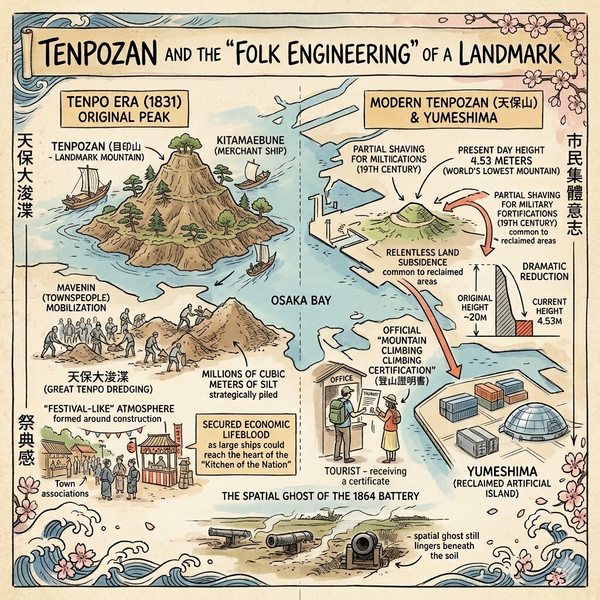
Tenpozan and the "Folk Engineering" of a Landmark
In 1831, the Edo Shogunate initiated the "Great Tenpo Dredging," a massive public works project designed to clear the silt-choked waterways of the Ajigawa and Yodogawa rivers. This was more than a drainage project; it was a masterclass in social engineering. By clearing the riverbeds, the city ensured that large merchant ships (Kitamaebune) could reach the heart of the "Kitchen of the Nation," securing Osaka's economic lifeblood.
The project was defined by an incredible mobilization of the Machinin (townspeople) class. Millions of cubic meters of silt were strategically piled at the river’s mouth to create an artificial peak. Named "Tenpozan" after the era, it also became known as Mejirushi-yama (Landmark Mountain), serving as a vital navigation marker.
"During the construction period, a 'festival-like' atmosphere formed around Tenpozan. Various town associations donated funds, and a social climate evolved where participating in the engineering work was considered a matter of great pride."
While originally reaching a height of approximately 20 meters, Tenpozan has since "shrunk" to a mere 4.53 meters. This dramatic reduction is a testament to the fragility of artificial land: the peak was partially leveled in the late 19th century for military fortifications, while the rest succumbed to the relentless land subsidence common to reclaimed coastal areas. Today, it is celebrated with a touch of irony as "the world’s lowest mountain," where travelers can still receive an official "Mountain Climbing Certification" (登山證明書)—a cultural quirk that honors a peak born of human hands.
Tenpozan: Historical vs. Modern Status
Feature | Historical Data (c. 1831) | Current Status (Post-Subsidence) |
Height | Approx. 20 Meters | 4.53 Meters |
Primary Function | Navigation Marker & Scenic Spot | Cultural Landmark & Low-Peak Culture |
Social Context | Civic Pride & Waterway Management | Tourism & "Mountain Climbing" Certifications |
As one walks past the pine trees of Tenpozan today, the spatial ghost of the 1864 battery still lingers beneath the soil, where the scent of cherry blossoms once competed with the sulfur of coastal defense.

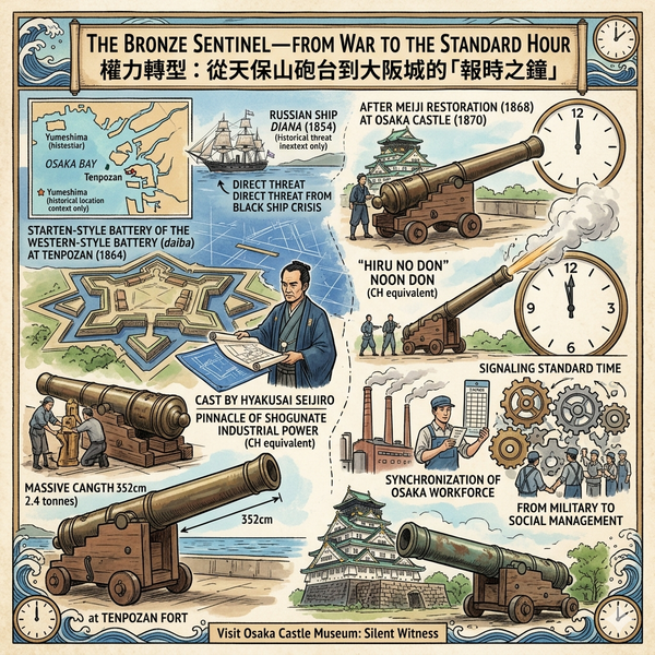
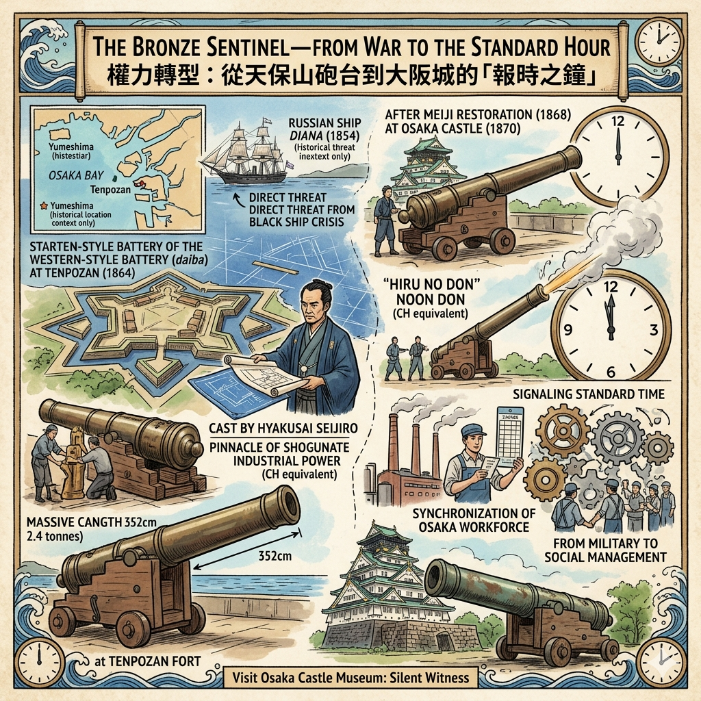
The Bronze Sentinel—From War to the Standard Hour
By 1854, the "Black Ship Crisis" reached Osaka Bay when the Russian ship Diana appeared, signaling a direct threat to the region's security. This forced a radical transformation: the pleasure grounds of Tenpozan were converted into a military bastion. In 1864, under the guidance of the visionary naval expert Katsu Kaishu, a Western-style battery (daiba) was constructed, featuring advanced star-shaped fortifications mirroring those of Goryokaku in Hakodate.
The centerpiece of this defense was a massive bronze cannon cast by the master founder Hyakusai Seijiro. Measuring 352cm and weighing 2.4 tons, the cannon represented the pinnacle of late-shogunate industrial capability. However, its military life was short-lived. Following the Meiji Restoration, the weapon was moved to Osaka Castle in 1870 and repurposed as the "Hiru no Don" (Noon Don). A weapon intended to repel foreigners became the city's primary tool for the synchronization of the Osaka workforce, signaling the arrival of "standard time" to a modernizing, industrial society.
Geographer’s Field Note: To see this displaced remnant of the bay’s defensive history, visit the Osaka Castle Museum. The original bronze cannon is displayed to the right of the main keep entrance, serving as a silent witness to the era when Osaka’s survival depended on the strength of its coastal batteries.
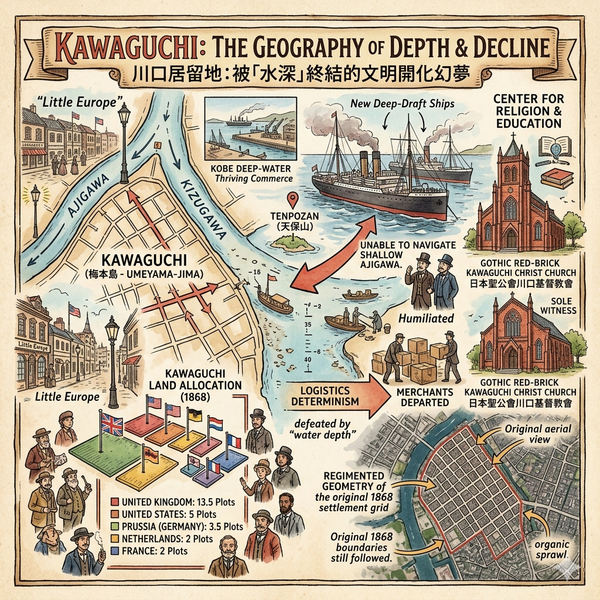
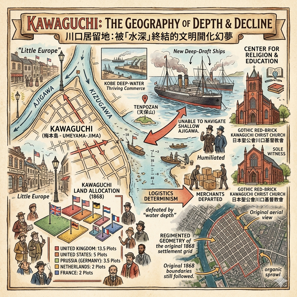
Kawaguchi—The Geography of Depth and Decline
In 1868, the Meiji government opened the Kawaguchi Foreign Settlement at the junction of the Ajigawa and Kizugawa rivers. Conceived as a "Little Europe," the area was divided into 26 plots for auction, attracting the UK, USA, and Prussia. It was intended to be Osaka's window to the global trade network.
However, the settlement was ultimately defeated by "logistics determinism." The Ajigawa river lacked the depth required for the new generation of deep-draft steel steamships. There was a palpable humiliation in seeing large vessels forced to anchor far offshore at Tenpozan, unable to navigate the shallow river, while the deep-water berths of Kobe stole the commercial future. By the 1890s, the merchants had largely departed, and Kawaguchi transitioned into a center for religion and education.
Today, the Gothic red-brick Kawaguchi Christ Church remains the sole physical witness to this era. When visiting, notice the regimented geometry of the street grid; these crisp, rectangular blocks still follow the original 1868 settlement boundaries, standing in sharp contrast to the organic sprawl of the surrounding districts.
Kawaguchi Land Allocation (1868)
- United Kingdom: 13.5 Plots
- United States: 5 Plots
- Prussia (Germany): 3.5 Plots
- Netherlands: 2 Plots
- France: 2 Plots
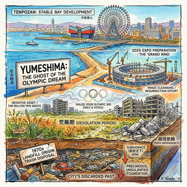
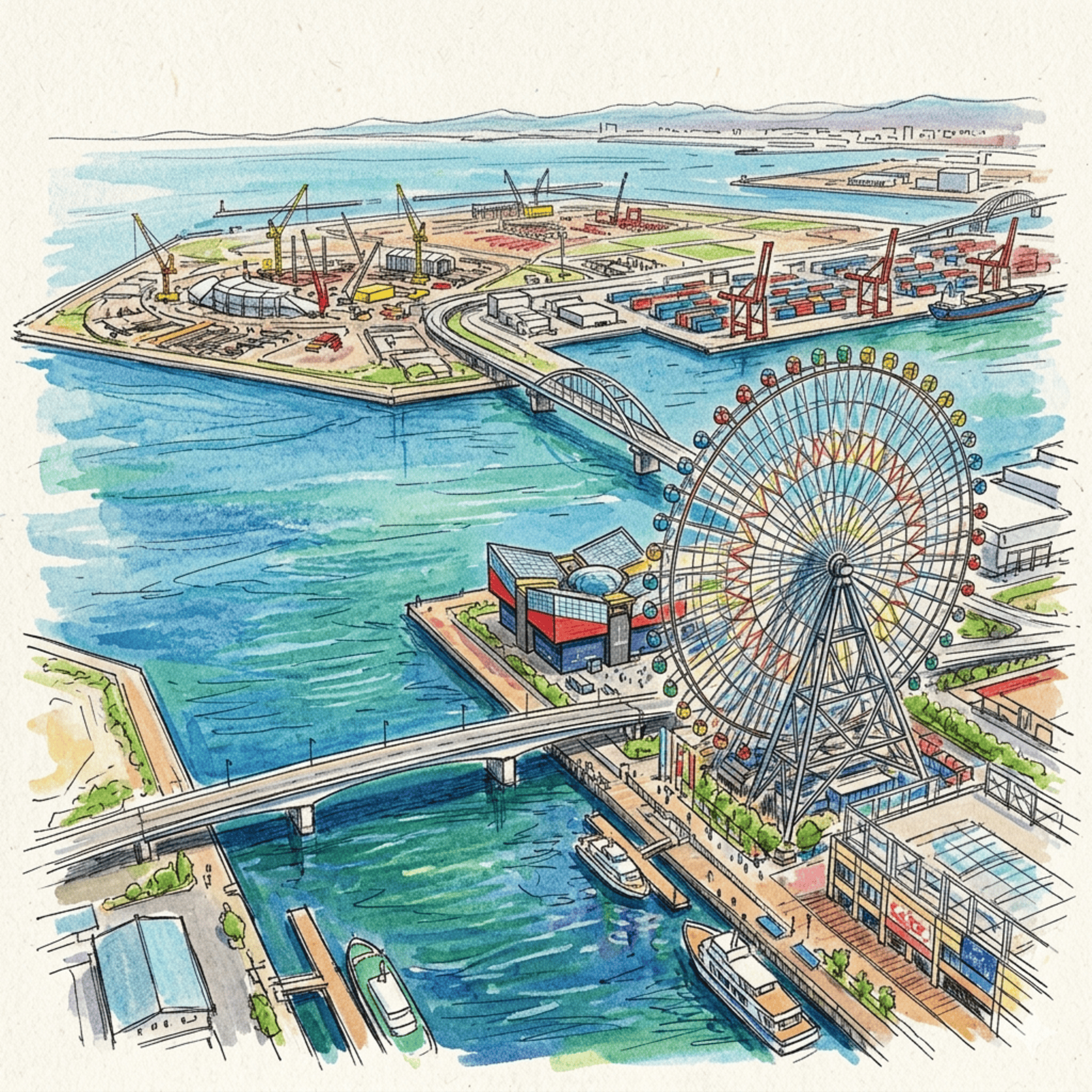
Yumeshima—The Ghost of the Olympic Dream
The story of Yumeshima began in 1977, not as a vision of grandeur, but as a waste disposal site. By the late 1980s, during the peak of the Japanese "bubble economy," it was rebranded as "Technoport Osaka," envisioned as a high-tech sub-center. The city tethered this dream to a bid for the 2008 Summer Olympics, planning Yumeshima as the site for the Olympic Village.
When the bid failed in 2001 (receiving only six votes), Yumeshima became a "Negative Asset." For two decades, it sat in a state of desolation (荒蕪期), a vast wasteland of weeds and unused land that had cost approximately 340 billion yen to reclaim. It was a stark reminder of the risks of "strong-arming" land value through international events without market support. Today, the island is undergoing a massive "image cleansing" for the 2025 World Expo, symbolized by the rising "Grand Ring" architecture—a new layer of concrete atop a precarious, unsolidified foundation of the city’s discarded past.

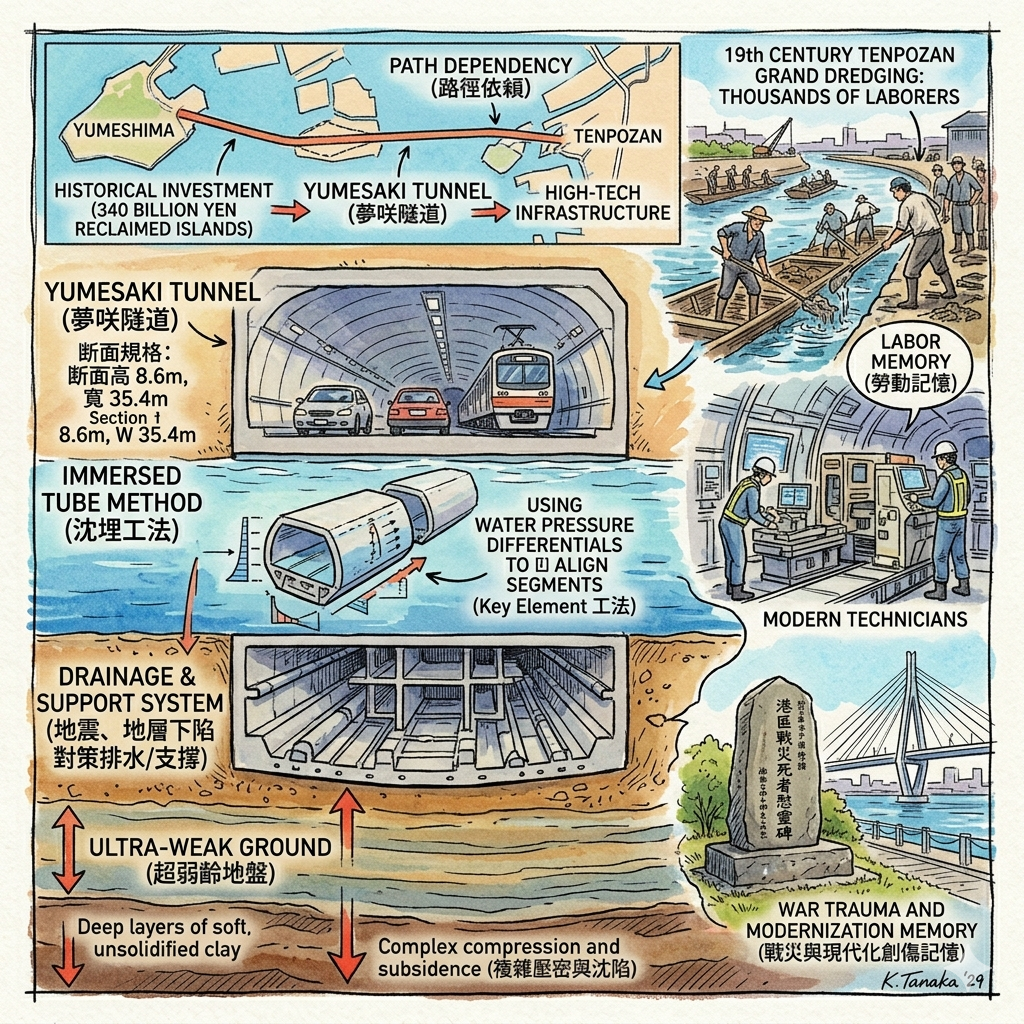
The Yumesaki Tunnel—Engineering the Mud
Connecting the isolated, liminal frontier of Yumeshima to the city required overcoming "ultra-weak ground"—deep layers of soft, unsolidified clay. The solution was the Yumesaki Tunnel, a strategic project using the "Immersed Tube Method." Engineers sank eight massive pre-cast concrete sections into the seabed.
The project utilized the "Key Element" technique, using water pressure differentials to perfectly align the final tunnel segment in a narrow channel. While a feat of modern engineering, the tunnel also represents a form of "path dependency." To save the massive historical investment of 340 billion yen in the reclaimed islands, the city must continue to spend billions on high-tech infrastructure to keep them connected to the mainland. It is a cycle of spending to justify the existence of land that is still undergoing complex compression and subsidence.

Yumesaki Tunnel Specifications
Metric | Detail |
Total Length (Immersed) | 800 Meters |
Cross-Section Dimensions | 35.4m Width x 8.6m Height |
Construction Method | Immersed Tube (8 Sections) |
Geological Foundation | Tenma Gravel Layer |
Metro Opening Date | January 19, 2025 |
Travel Framing: Hidden Gems & Walking Paths
For those seeking the human story beneath the engineering, visit the Minato-ku War Victims Memorial (Wei-kake Jizo) in Bentencho 3-chome. This small shrine serves as a poignant reminder of the labor and tragedy that defined the port's modernization and the scars of WWII air raids.
To experience the spatial transition of the bay, take the Osaka Metro Central Line. Start at the 19th-century riverbanks near Kawaguchi, stop at Osakako Station for Tenpozan, and finally ride the line through the Yumesaki Tunnel to the futuristic Yumeshima Station. This transit allows you to "walk" through two centuries of engineering history in a matter of minutes.
Conclusion: A Philosophical Reflection on the Artificial Coast
The history of Osaka’s bay is a cycle of perpetual reconstruction. Because these areas exist on the "border" between land and sea, they remain the preferred sites for social and technical experiments. From Katsu Kaishu’s star-shaped battery to the Expo’s "Grand Ring," the bay is where Osaka projects its future, unburdened by the traditional constraints of the city center.
Yet, there is a profound fragility to this artificiality. The city is engaged in a constant battle against land subsidence and the geologic instability of its reclaimed frontiers. The land is never truly "finished"; it requires a relentless human will and continuous technological input to maintain its existence against the methane of the waste layers and the shifting alluvial mud.
Ultimately, we must ask: Is a city defined by its natural foundations, or by the relentless human will to maintain land where the sea intends to be? Osaka chooses the latter, proving that even on a foundation of mud and silt, one can build a dream—provided they are willing to keep dredging.
Logistics for the Historical Traveler
- Access: Use the Osaka Metro Central Line. Reach Tenpozan via Osakako Station. For the newest layer of the frontier, continue to Yumeshima Station.
- Accommodation: Stay in the Bentencho or Bay Area districts for easy access to both the historic riverfronts and the modern island attractions.
- Recommended Tours: Look for specialized walking tours of the Kawaguchi Red-Brick District and the Minato-ku waterfront to fully appreciate the architectural heritage and labor history of the Meiji era.
Enjoyed this deep-dive? Subscribe to Historical Travel Stories for more narratives that explore the "why" behind the world's most fascinating places.
Reference and Further reading
- 天保山(てんぽうざん)跡 - 大阪市, accessed March 20, 2026,
- 大阪市, accessed March 20, 2026,
- 勝海舟が設計!兵庫の海を守った幕末の「洋式砲台」とは?知られざる4大砲台と海防の歴史を徹底解説 - 70歳から始めた幕末の歴史散策, accessed March 20, 2026,
- 天保山台場跡, accessed March 20, 2026,
- 特別展 和田岬砲台史跡指定100年記念 大阪湾の防備と台場展 - 神戸市立博物館, accessed March 20, 2026,
- モダン大阪発祥の地・川口居留地をゆく - 大阪あそ歩, accessed March 20, 2026,
- FUJITSUファミリ会 2018年度連載, accessed March 20, 2026,
- 安治川橋 反り橋、旋回橋と形を変え、船の往来を見守り続けた居留地の橋【大阪市西区】, accessed March 20, 2026,
- 9.川口居留地跡, accessed March 20, 2026,
- 外国人居留地 - accessed March 20, 2026,
- 夢洲、ペンペン草生える負の遺産…大阪・関西万博とカジノは ..., accessed March 20, 2026,
- 知ってる?大阪・関西万博が開催地である夢洲。もともと何のために造成された?【1分雑学クイズ】, accessed March 20, 2026,
- 沈埋トンネル|国土交通省近畿地方整備局 神戸港湾空港技術調査事務所, accessed March 20, 2026,
- 厳しい施工条件を克服した夢咲トンネルの整備, accessed March 20, 2026,
- 関西の埋立地開発史|2025年大阪万博・夢洲から神戸ポートアイランド・西神まで, accessed March 20, 2026,
- 大阪港咲 洲トンネル - 五洋建設株式会社, accessed March 20, 2026,
- 港区戦災死者有縁無縁精霊碑 - 総務省, accessed March 20, 2026,
- 港区戦災死者有縁無縁精霊碑, accessed March 20, 2026,
- 夢咲トンネル - accessed March 20, 2026