Tucheng, New Taipei City: Five Histories of a Frontier Town Built Around Lines
Explore Tucheng, a New Taipei City district built on lines and boundaries. This historical travel story uncovers five surprising local layers: a severed prehistoric hill, an earthen defensive wall, a communal grave of refugees, a mountain monk's cave, and a tragic coal mine.

💡 Join a community of discerning travelers. Simply enter your email to instantly unlock audio guides and one-day itineraries, and carry our exclusive historical walking maps with you on your journey.
This is a historical travel story and walking guide to Tucheng, a frontier town in New Taipei City, Taiwan. Through five surprising histories—from prehistoric ridge sites and Qing-era walls to mass graves, a mountain monk, and a tragic mine—it explores how colonial expansion, faith, and industry shaped the landscape.
 Lawrence
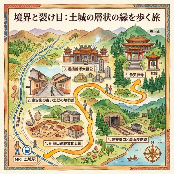
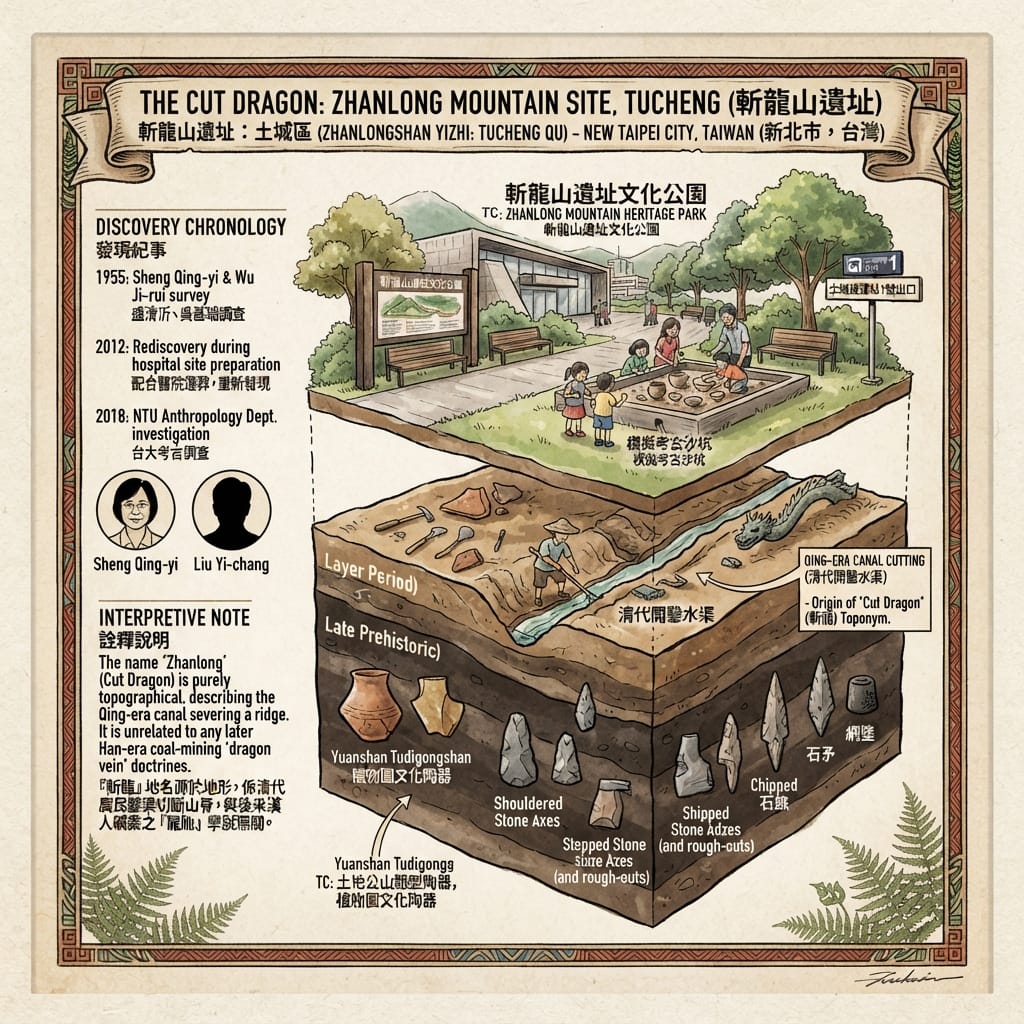
Beside Tucheng MRT station there is a park with a sandbox in it. It is meant as a simulated excavation: visitors brush away the sand and uncover replicas of a pottery type made on this ridge roughly two thousand years ago. The real objects, stone axes, adzes and pottery, were found in the ground nearby, in 1955 and again in 2012. The park is called Zhanlong Mountain Heritage Park, and the name translates as Beheaded Dragon Mountain. It is a violent name for a modest hill beside a river, and the story behind it is, as far as the sources show, an irrigation channel. Someone wanted water. The district around the park is full of decisions of that kind, each one drawing a line across land that already had people in it.
I. The hill that was cut
The ridge ran toward the Dahan River, and local usage compared its outline to a dragon's back. In the Qing period farmers cut a water channel through it, and the severed hill took its name from the cut. The year of the cutting is not given in any source I could find, and the "dragon" here is a place-name, not evidence of geomantic intent; the hill was named for what was done to it.
The Farmers Who Beheaded A Dragon
What lay under it was older. The material found there belongs to the Tudigongshan type of the Yuanshan culture and to the later Botanical Garden culture, and is dated to between about 2,800 and 1,800 years ago: shouldered stone axes, stepped adzes, arrowheads, net weights, pottery. The researcher Sheng Qing-yi recorded the site in 1955, by which time a road had already cut across it. The record then went quiet. In 2012 contractors moving graves out of Tucheng's first public cemetery, to clear ground for a municipal hospital, struck pottery and stone tools again. Liu Yi-chang of Academia Sinica identified them as belonging to the same cultural horizon. The modern dead were being relocated, and the very old dead surfaced beneath them.
Nothing survives that tells us what these riverside people believed. No text, no decoded symbol, no alignment. That absence should be left as it is. A park opened on part of the site in 2019, and a university anthropology team surveyed the area in 2018.
II. The wall
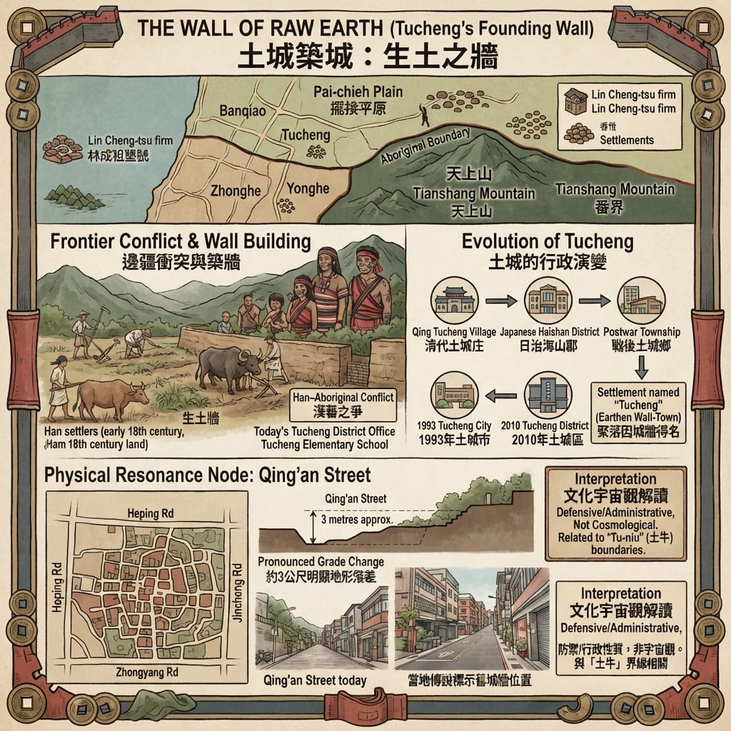
The Qing state drew a boundary between Han farmland and the Atayal territory around Tianshang Mountain. Settlers from Zhangzhou, working through reclamation firms, pushed past it. One account, from a city-magazine feature, names the firm of Lin Cheng-tsu and the year 1750; the district's own history page dates large-scale reclamation to 1736, and the Pai-chieh administrative unit to 1723. The sources do not agree on a single founding date, and it is probably better to read this as a process than an event.
Conflict followed, and the settlers built a wall of packed earth around their houses, near where the district office and an elementary school now stand. Its first purpose was defence. Later it served as a place to gather grain and keep order. Because it resembled a walled town, the settlement was called Tucheng, "earthen wall-town".
The City Named Dirt Wall
The contradiction is in the order of events. The wall was a defence against a conflict that the settlers' own expansion had helped to create. We have the settlers' side of this in the records; the Atayal account of the boundary is not in the sources I could reach, and it should be sought.
The name outlasted the wall by more than two centuries: Tucheng village under Qing rule, Tucheng village again in 1920 within Haishan County of Taihoku Prefecture under Japanese administration, a township after 1946, a county-administered city in 1993 when the population passed 150,000, and a district of New Taipei City since 2010.
No part of the wall is known to survive. A local walking-tour account suggests that the raised ground along Qing'an Street, where buildings sit about three metres above the lane beside them, may follow the old line. That is an inference by guides, not an excavation result.
III. The grave
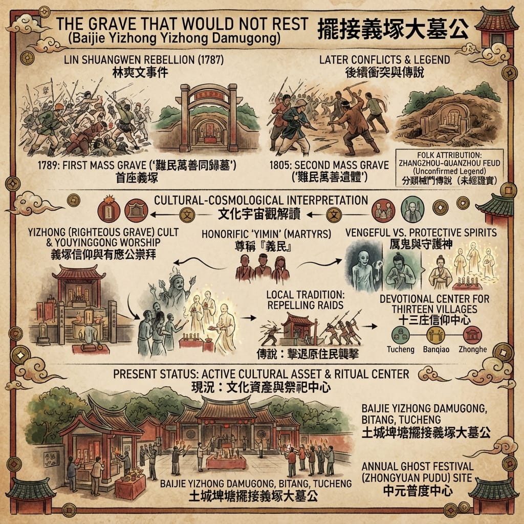
The Lin Shuangwen Rebellion was the largest civil uprising in Qing-ruled Taiwan, and it reached the Pai-chieh plain. In 1789 the thirteen villages of Pai-chieh (six in today's Tucheng, three in Banqiao, four in Zhonghe) buried the dead in a communal grave and named it for them: the tomb where refugees and the myriad good return together. In 1805 a second mass grave nearby received the dead of renewed conflict between Han settlers and Aboriginal people. These two burials are documented.
Later tradition adds a third layer, the casualties of a Zhangzhou–Quanzhou feud, sometimes tied to water rights. Chinese Wikipedia, which records this, also notes that no primary Qing-period record confirms such a feud in this area. It should be read as local tradition.
The Grave That Would Not Rest
What is not in doubt is the practice. In Taiwanese folk religion the unclaimed dead are not only mourned but worshipped, as yimin, "righteous people", in a yizhong, "righteous grave". The belief behind this is that neglected dead wander and cause harm, and properly honoured dead protect. Local tradition says that settlers who prayed here against raiders were answered. That is a belief about the grave's power, held by the community, and this article does not treat it as a verifiable event.
An essay on the shrine's origins, published by a folklore site, asks in its title whether the dead were righteous people, refugees or rebels. The grave itself chose "refugees". The question has no recorded answer, and the shrine has kept the dead together without having to settle it.
The thirteen villages' representatives managed the shrine from the Qing period, and local heads of Tucheng, Banqiao and Zhonghe took over under Japanese rule and continued, in some form, until at least 2011. It is now a registered municipal cultural asset. In 2018 a Mirror Media investigation reported a dispute over its governance and assets.
IV. The monk who ate fruit
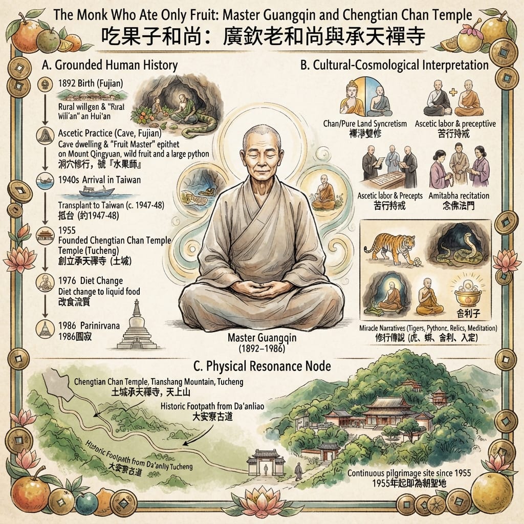
Guangqin was born in 1892 in Hui'an, Fujian, and at the age of four was sold by his poor family into a household in Jinjiang. He was ordained in 1927 at Chengtian Temple in Quanzhou, took full precepts in Putian in 1933, and then lived for more than ten years in a cave on Mount Qingyuan, eating mostly wild fruit. That diet gave him the name "the Fruit Master". He reached Taiwan in the late 1940s (sources give 1947 or 1948), spent time in a cave at Riyuedong near Sanxia, and in 1955 founded a temple on the western side of Tianshang Mountain, naming it after the temple of his ordination.
He kept to fruit until 1976, when his teeth failed and he moved to liquid food. His reputation for discipline drew pilgrims through the 1960s and 1970s in numbers the small temple could not hold, and it was rebuilt in 1975. The contradiction is plain: a man who withdrew from the world to eat what the mountain offered became the reason a crowd came up the mountain. He died in December 1986 at Miaotong Temple, and his relics were divided among three temples he had founded.
How The Fruit Master Lived
Stories attach to him, a tiger that took refuge at his feet, a python that left his cave, days-long meditative absorption, relics said to number over a thousand. They come from devotional literature compiled by disciples. They are evidence of what his followers believed, and this article records them only as belief.
Holographic Sensory Cue: The footpath from Da'anliao to Chengtian Temple takes about half an hour on foot and runs through forest. On a shaded slope in a humid subtropical climate the path is typically cooler and wetter than the streets below. This is a present-day observation, and it makes no claim about what any earlier pilgrim felt.
V. The mine
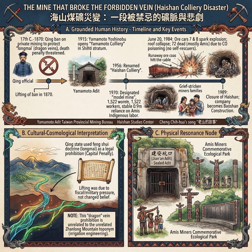
Qing policy banned private coal mining across Taiwan, and the stated reason was geomantic: digging coal was said to damage the longmai, the dragon veins under the land. Stone tablets threatened death for violators. The ban was enforced unevenly, and it was lifted in 1870 under commercial and official demand, including, one source says, the needs of the Fuzhou Navy Yard. The coal measures under Tucheng lay within the area covered by the ban.
In 1915 a Japanese businessman, Yamamoto Yoshinobu, opened a colliery there. After the war it passed through several owners and in 1955 was bought by three members of the Li family of Ruifang, becoming Haishan Colliery the following year. By 1970 it employed 1,522 people and was designated a "model colliery" for a thick, stable, gently sloping seam. As Taiwan's coal industry declined in the 1970s, the mine relied increasingly on Amis workers from the east coast who had migrated for wages.
The Safest Mine S Deadly Secret
On 20 June 1984 two ore cars ran loose underground after a coupling pin was not properly secured. They struck a high-voltage cable, and the spark ignited coal dust in the air. A roof collapse followed, blocking escape. Survivors of the blast died of carbon monoxide, because the required self-rescue breathing units had not been issued that day. Seventy-two miners died (some accounts say 74), most of them Amis. Management reportedly waited three hours before telling the provincial mining bureau. Two other major mine disasters followed in the same year elsewhere in Taiwan; together the three killed nearly 300. Haishan stopped production in December 1989, and its parent company later became a construction firm.
The contradiction needs no commentary: the mine was a model operation fourteen years before the disaster. It would be easy to join the Qing ban and the 1984 accident into a story of a forbidden vein avenged. The records do not support that. The accident had mechanical and procedural causes. The two events are linked only by the ground they concern, and by the fact that in both, the people who bore the cost were not the people who decided.
The Resonance Node
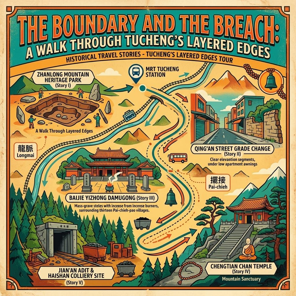
Four places in Tucheng still carry these layers: the park at Zhanlong Mountain, the raised ground on Qing'an Street, the tomb-shrine in the Bitang area, and the sealed Jian'an adit on the heritage walk through the former Haishan mining settlement. None of them is marked as dramatically as its history would justify. The adit stands next to an Indigenous ecological park that commemorates the Amis miners.
The present-day place
Almost nothing built before the twentieth century stands in Tucheng. The wall is gone, the colliery is closed, and the monk's cave-dwelling years belong to Fujian. What remains is the shape of the land and the names: a street that rises without explanation, a park over a surveyed site, a temple that still receives pilgrims, a shrine that still receives incense. Walking from the MRT through the apartment blocks, you pass over a frontier, a battlefield, a hermitage's foothills and a coal seam in less than an hour. Most of it looks like an ordinary satellite district of Taipei, which is also true.
An ending
The Ghost Festival rites at the Damugong shrine rotate each year among Tucheng, Banqiao and Zhonghe. The rites move to another district, and the dead stay where they are.
Accessing the Physical Node
- Getting there: Tucheng District lies in the south-west of the Taipei Basin. The Taipei MRT Bannan (Blue) Line serves it at Haishan and Tucheng stations.
- Zhanlong Mountain Heritage Park: Jincheng Road Section 2, near Tucheng Station Exit 1. A public park; opening hours should be checked locally.
- Qing'an Street: in the old town core, near the district office; walkable from the stations. No marker is known to me.
- Chengtian Temple: on the western slope of Tianshang Mountain, reached on foot from the Da'anliao trailhead (about 30 minutes by one account). Active temple, open to visitors; observe temple etiquette.
- Baijie Yizhong Damugong: Bitang area, an active shrine open to visitors, though access may differ around its annual festival.
- Haishan mining area: Jian'an adit and the Indigenous ecological park, reached through community heritage walks, which run irregularly. Expect a residential and light-industrial district, not a museum.
- Opening hours, routes and transport details were not verified for this edition. Further verification recommended before travel.
Notes on evidence. Disputed or uncertain: the year of the canal cutting; the wall's founding date (1723, 1736 or 1750 in different sources); the Zhangzhou–Quanzhou feud at the shrine; Guangqin's arrival year; the death toll (72 or 74). Legends of Guangqin are recorded as belief. Indigenous (Ketagalan, Atayal) perspectives are largely absent from the sources consulted. Further archival verification recommended.
💡Q&A
Q1 | Did Tucheng get its name from an ancient city wall, and how did the Qing-era Pai-chieh Plain earthen defensive wall and settlement originate? (Tucheng District Name Origin and Han Settler Defense Historical Research)
A:The name Tucheng literally means "earthen wall-town," originating from defensive packed-earth walls built by Qing-era settlers. During the mid-18th century, Zhangzhou immigrants pushing reclamation claims past official boundaries into Atayal territory near Tianshang Mountain faced frequent conflicts. Settlers built earthen walls around their settlement near the modern district office and elementary school for defense and grain storage. While no physical remnants of the wall survive today, local walking guides suggest that the elevated ground along Qing'an Street—sitting about three meters above adjacent lanes—may trace the former wall's alignment. Administratively, the settlement evolved from a Qing village to Japanese colonial jurisdiction under Haishan County, post-war township status, and eventually a district of New Taipei City in 2010.
Q2 | How was the Zhanlong Mountain archaeological site discovered, and what do its prehistoric Yuanshan and Botanical Garden cultural layers reveal? (Zhanlong Mountain Heritage Park and Prehistoric Archaeological Research)
A:The Zhanlong Mountain site was first recorded by researcher Sheng Qing-yi in 1955 after a road cut through the ridge. In 2012, excavation work for a municipal hospital project clearing Tucheng's first public cemetery unearthed extensive pottery shards and stone implements. Academia Sinica archaeologist Liu Yi-chang identified these artifacts as belonging to the Tudigongshan type of the Yuanshan culture and the subsequent Botanical Garden culture, dating back roughly 2,800 to 1,800 years. The site yielded shouldered stone axes, stepped adzes, arrowheads, net weights, and pottery from ancient riverside dwellers. Part of the site was officially opened to the public as Zhanlong Mountain Heritage Park in 2019, bridging prehistoric strata with the modern urban landscape.
Q3 | What is the historical significance of the Jian'an Adit in Tucheng's Haishan coal mining district, and how is it connected to the 1984 mining disaster and indigenous workers? (Jian'an Adit Coal Mining History and Amis Miner Memory)
A:Located in the Haishan coal mining district, the Jian'an Adit descends into historic coal-bearing strata, bearing witness to Taiwan's bygone industrial era. On June 20, 1984, the Haishan Mine suffered a catastrophic disaster that claimed numerous lives, leaving a deeply painful legacy in Taiwan's labor history. Many indigenous workers, particularly from the Amis community in Hualien and Taitung, worked in these hazardous mines to fuel Taiwan's energy needs. Although the adit is now sealed, the site features an indigenous ecological park and interpretive walking trail that preserves the poignant history of industrial transformation and labor migration.
Want to follow the historical routes I’ve selected right from your phone as you walk? Click to join the exclusive Google map of historical tours titled "Historical Travel Stories"—import it to Google Maps on your phone with a single tap and let it guide you as you visit each historical site in person.

📖Reference and Further reading📖
First layer – Main sources of literature and institutions:
- Tucheng District Office, 昔時今日 (local history and administrative timeline)
- New Taipei City Cultural Affairs Bureau, 斬龍山遺址文化公園
- New Taipei City Tourism, 斬龍山遺址文化公園
- Taiwan Religious Culture Map (MOI), 土城大墓公中元祭典
- New Taipei City Hakka Folk Belief Museum, 土城埤塘義塚大墓公
- CHIBS (NTU), Taiwan Buddhism Digital Museum, 廣欽法師
- Miaotong Temple, 廣欽老和尚生平
- National Cultural Memory Bank, 海山煤礦股份有限公司與土城煤礦聚落
- National Cultural Memory Bank, 海山煤礦災變
- New Taipei City Cultural Affairs Bureau, 海山地區煤礦業遺址調查報告
The second layer – secondary academic materials:
- Chinese Wikipedia, 土城區
- Tamsui Wiki (Tamkang University), 土城
- Chinese Wikipedia, 斬龍山遺址
- Chinese Wikipedia, 擺接義塚大墓公
- Taiwan Folklore Think, 義民、難民、還是亂民?土城大墓公的奉祀源起
- Chinese Wikipedia, 釋廣欽
- Chinese Wikipedia, 海山煤礦
Third layer – Supplementary information:
- 城市學 (GVM), 以前真的有座土城分隔東西!
- New Taipei City Cultural Foundation, 穿越土城探訪百年擺接風華 (2024 walking tour)
- PeoPo Citizen Journalism, 土城斬龍山史前文化遺址
- Vocus (bravejim), 斬龍山遺址文化公園
- Mirror Media, 50億大墓公 (2018)
- New Taipei City Tourism, 義塚大墓公
- TravelKing, 承天禪寺
- Chengtian Temple, 無處不自在的水果法師
- Book853, 廣欽老和尚事略
- KKNews, 「水果師」「伏虎和尚」
- 重大歷史懸疑案件調查辦公室, 海山礦災事件
- NTPU Haishan Museum, 煤礦
The Tier 3 devotional sources (Book853, KKNews, Chengtian Temple’s own article) are where the Guangqin miracle stories come from, so they stay marked as belief rather than fact. A few other pages I retrieved are left out because the dossier doesn’t rely on them. I couldn’t open the 1956 Taiwan Provincial Gazette entry or the Qu Haiyuan (1992) gazette that Wikipedia cites for the Damugong history, so those are only second-hand through the Wikipedia entry.
 Lawrence
 Lawrence
 Lawrence