東京杉並町:只當了八年「町」的地方,與那些比實物更長壽的名字
這是一篇東京杉並的歷史散步故事。透過青梅街道的消失杉樹界標、天沼求雨池與關東大地震後的鐵路擴張,帶你探索只當了八年「町」的杉並,感受地名如何比實物更長壽的城市記憶。

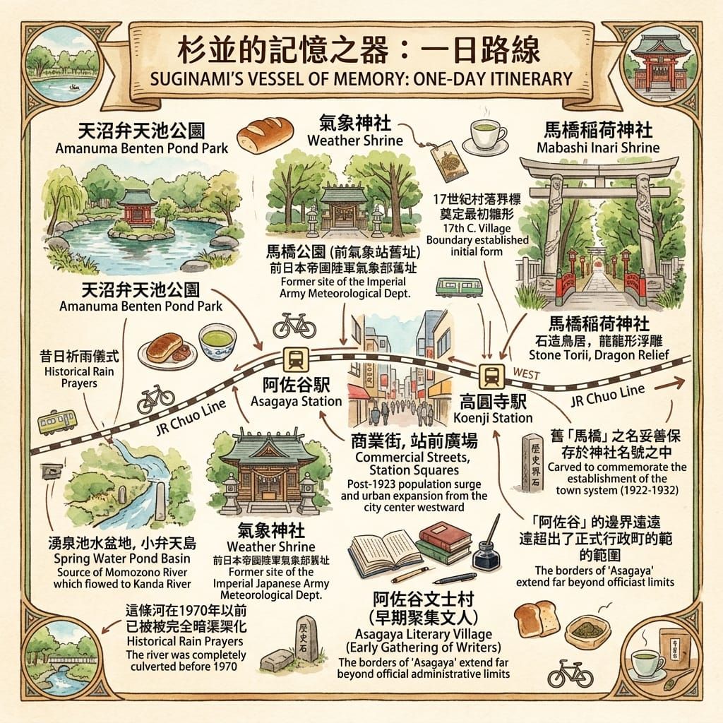
這是一篇關於東京杉並區的歷史散步故事與深度導覽。文章沿著青梅街道、天沼湧泉與中央線沿線漫步,透過消失的杉樹界標、求雨池與關東大地震後的住宅急遽擴張,探索地名如何比實物更長壽,帶領讀者感受東京西郊的庶民地緣歷史與城市記憶。
這裡沒有走馬看花的打卡路線,只有立足於官方文獻(3 Tiers 考據)、結合短片的深度地緣歷史調查。每日,我們為你免費開拓一處連在地人都不知道的城市秘境。
💡 加入目前深度旅人的行列,輸入 Email 即可隨即解鎖廣播及一日旅遊行程,隨身攜帶我們專屬的歷史散步地圖。
 Lawrence
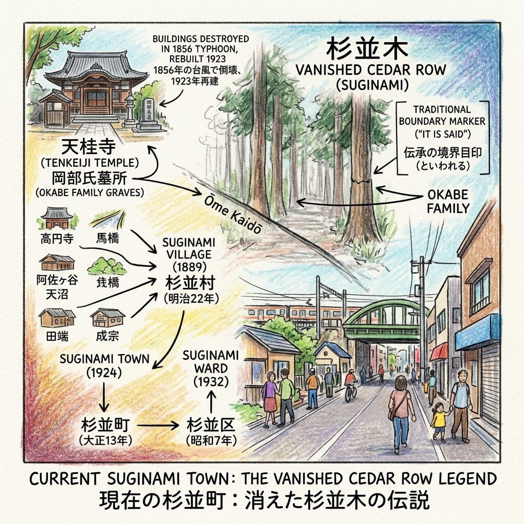
走在東京西部的青梅街道(Ōme Kaidō)上,找不到一棵杉樹。街上有車流、藥房,還有連鎖餐廳。可是整個杉並區(Suginami Ward)的名字,卻來自這條路旁一排沒有人見過的杉樹。
日本官方的說法很謹慎,只寫「據說」:江戶時代初期,成宗(Narimune)與田端(Tabata)兩村的領主岡部氏,沿青梅街道種下杉樹,作為領地的界標。到了明治以前,樹已經不在了。一八八九年,六個村子合併,新村取名「杉並」,名字比實物多活了不知多少年。
一、杉樹與界標
要找岡部氏,不必找樹,去天桂寺(Tenkeiji)便行。這座曹洞宗寺院在今日的成田東,約於寬永十年(一六三三年)前後,由岡部吉正(Okabe Yoshimasa)創建。他先是北條氏重臣松田康秀(Matsuda Yasuhide)的家臣,北條氏滅亡後成為德川幕府的旗本。岡部家歷代的墓,今日列為杉並區有形文化財。安政三年(一八五六年)一場大風暴摧毀了全部建築,現存本堂建於一九二三年。
The Phantom Trees Of Suginami
一排樹,本來只是用來說「此處為界」。後來它成了村名、町名,最後成了面積約三十四平方公里的區名。界標之大,竟至於此。
二、一個求雨的池
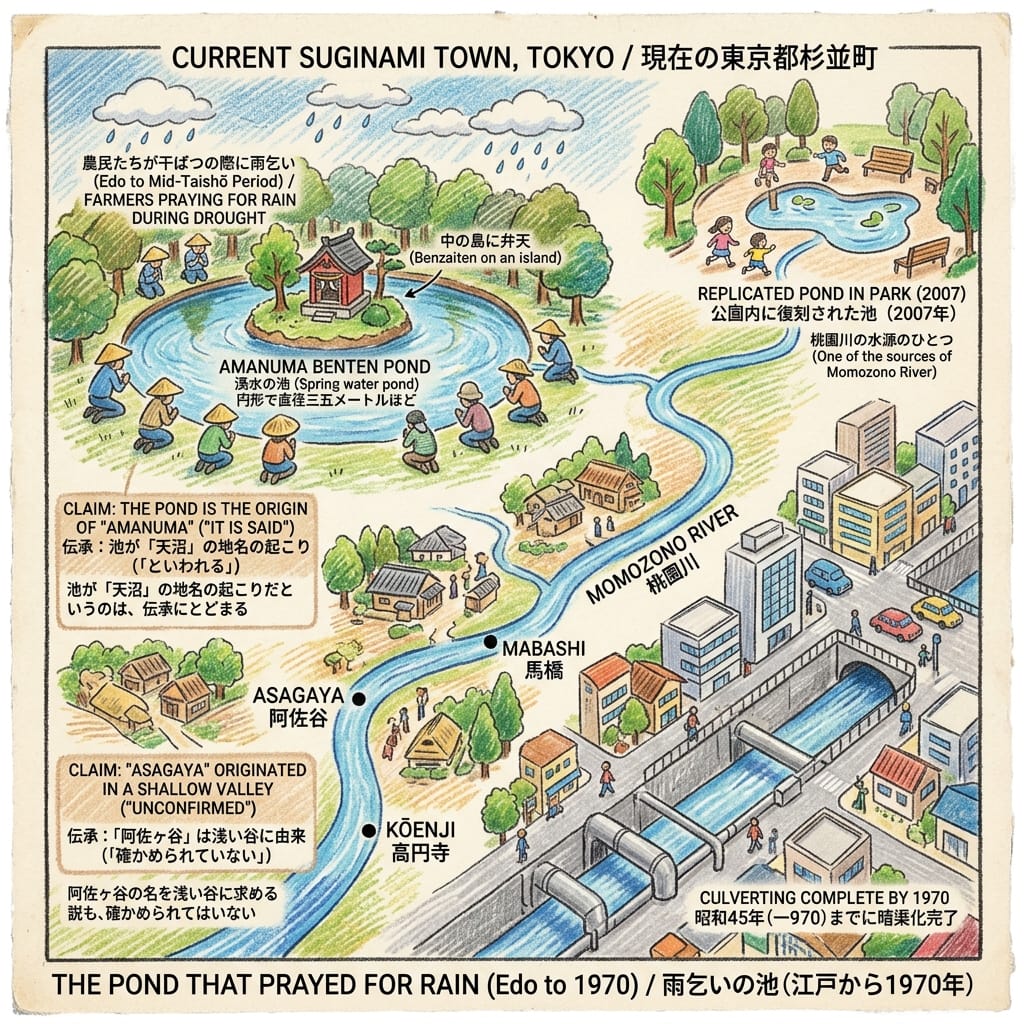
沿青梅街道往北,天沼(Amanuma)曾有一個湧泉池,直徑約三十五米,池心小島供奉辯才天(弁天,Benzaiten)。據杉並區的紀錄,直至大正中期,遇上旱災,農民仍會聚到池邊祈雨。池水是桃園川(Momozono River)的水源之一,河水向東流經阿佐谷(Asagaya)、馬橋(Mabashi)與高圓寺(Kōenji),匯入神田川。
Tokyo S Ghost River
河水不豐,江戶中期要從千川上水與善福寺川引水補給。「桃園川」這個名稱,據說要到一九三〇年代後半才通行。戰後,它被劃為準用河川,一九七〇年完成加蓋,成了下水道幹線。今日的池,是二〇〇七年在公園內重建的。地名「天沼」是否源於這個池,只是傳說;「阿佐谷」出自淺谷,也是未經證實的說法。
香港人對這種事並不陌生:許多街名記住的海岸線,早已被填海工程推到遠處。名字留下了,水卻走了。
三、車站與一個四倍的町
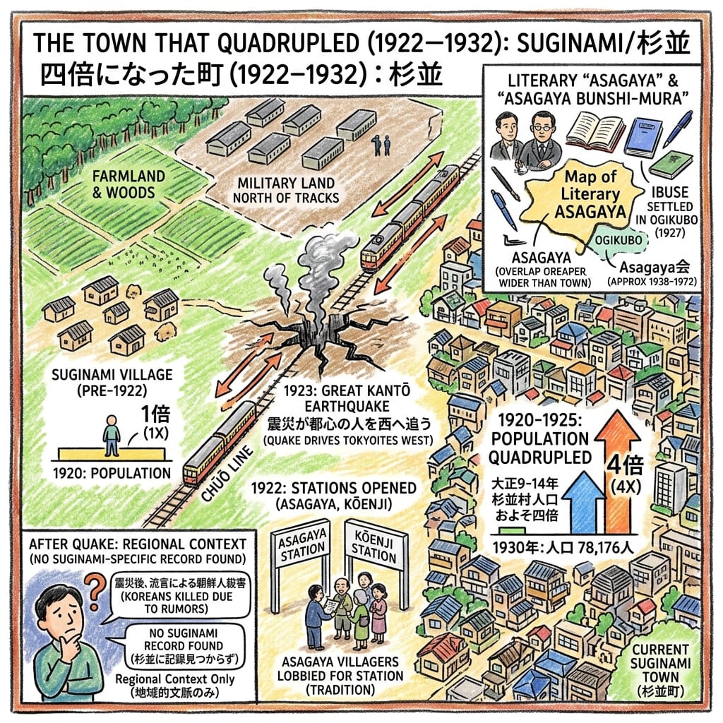
一九二二年七月,中央線的阿佐谷與高圓寺兩站啟用。此前,中野至荻窪之間,大部分是農田與雜木林,鐵路以北是軍用地。翌年九月,關東大地震摧毀東京市中心,許多人沿中央線向西遷居。由一九二〇年到一九二五年,杉並村人口增至約四倍;一九二四年升格為町,一九三〇年人口為七萬八千一百七十六人。
How A Disaster Built A Tokyo Suburb
作家們也來了,形成後來所謂「阿佐谷文士村」,以井伏鱒二(Ibuse Masuji)為中心,聚會約由三十年代末持續到七十年代初。但要補一句:井伏鱒二住的是荻窪(Ogikubo),當時屬鄰町井荻。所謂「阿佐谷」的文學地圖,比杉並町的行政地圖要大。
還有一點不能繞開。同一場地震之後,軍隊、警察與民間自警團曾在關東各地殺害大量朝鮮人,起因是毫無根據的謠言。我沒有找到記錄把這些事件指向杉並,所以不作任何指稱;但一個建築在災難之上的郊區,終歸與災難所做過的事比鄰而居。
四、氣象神社
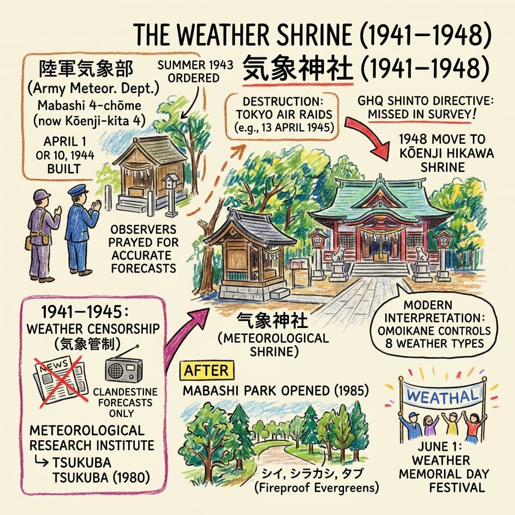
一九四〇年代,馬橋四丁目(今高圓寺北四丁目)有一座日本陸軍氣象部。一九四一年十二月八日,日本實施氣象管制,直到戰爭結束,長達三年零八個月;報紙與電台再無天氣預報。預報仍然在做,只是關在圍牆裏頭。
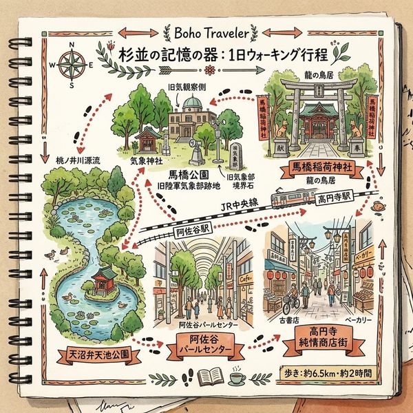
一九四三年夏天,氣象部部長下令建一座神社,一九四四年四月落成,祭神是智慧之神八意思兼命(Yagokoro-omoikane-no-mikoto)。觀測員上班前,會祈求預報準確。一九四五年,神社毀於空襲,後來重建。戰後,駐日盟軍總司令部(GHQ)發出神道指令,國家神道的神社被廢除,但這座神社在調查中被漏掉了。它本來預定移往馬橋稻荷神社,最後由兩邊的神職人員商議,在一九四八年遷到高圓寺的氷川神社(Hikawa Shrine)。據杉並區所載,這是日本唯一的氣象神社。
Japan S Secret Wwii Weather Shrine
舊址,戰後成了氣象研究所,一九八〇年遷往筑波,一九八五年三月,改為馬橋公園(Mabashi Park)。
Holographic Sensory Cue: 馬橋公園內種的是防火的常綠樹,包括椎、白橡與楠木類樹種,這是為防災而設計的,現場仍可看到。神社每年六月一日(氣象紀念日)舉行祭典。
五、名字與容器
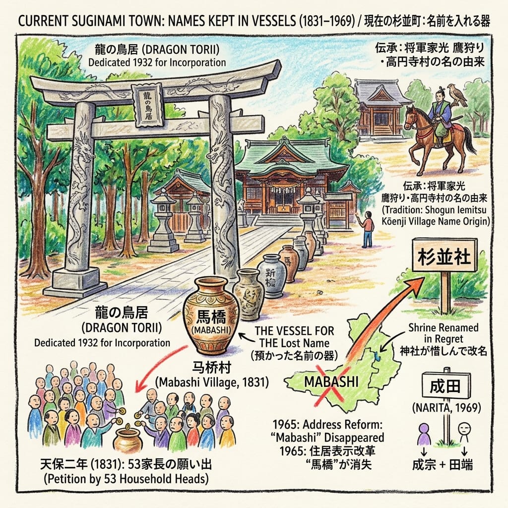
馬橋的故事,要看馬橋稻荷神社(Mabashi Inari Shrine)。天保二年(一八三一年),馬橋村全部五十三位家長湊錢,向京都的神祇伯家請求賜予稻荷神的神號。一九三二年,町被併入東京市,這裏奉納了一座雕有昇龍與降龍的石鳥居,作為紀念。(杉並區的介紹寫作「村」,但那時已是町。)
The Village A Shrine Refused To Forget
一九六五年,新的住居表示令「馬橋」這個地名從地圖上消失,神社出於惋惜,把自己改名為「馬橋稻荷神社」。一九六九年,成宗與田端兩個舊村名,各取一字,合成「成田」(Narita)。高圓寺(Kōenji)的名字則走另一條路:傳說三代將軍德川家光(Tokugawa Iemitsu)鷹狩時曾到曹洞宗的高圓寺寺,村名由此而來;這屬於傳統說法,並非定論。
Resonance Node: 馬橋稻荷神社的龍鳥居。一個已從地圖上除掉的名字,在這裏由神社保管。
今日的杉並
杉樹、水池、河流、軍營,都不在了。仍在的有:氣象神社與二〇〇三年重建的小殿;天桂寺的岡部家墓,與刻有寬文四年(一六六四年)的石觀音;那座龍鳥居;高圓寺一帶,一條河流改成步道後留下的橋柱(據遊人所記);以及公園裏的防火樹。
站在氣象神社前,會發覺這裏失去的,大多是「可以叫得出名字」的東西:一排樹、一個池、一條河、一個村、一支軍隊。留下來的,是一種習慣:把名字搬進新的容器,神社、公園,或者一個區。
最後一句
一九六五年,有人為了不讓一個詞從地圖上消失,替神社改了名。
實地探訪(Accessing the Physical Node)
- 交通: JR中央線至高圓寺、阿佐谷或荻窪站,由新宿約八至十分鐘。
- 氣象神社(高圓寺氷川神社): 高圓寺南4-44-19,由JR高圓寺站步行約兩分鐘。境內開放。氣象祭在六月一日;八月下旬的東京高圓寺阿波舞,據載一九五七年起以奉納舞形式開始。
- 馬橋公園: 高圓寺北4-35-5,由高圓寺站步行約十五分鐘,免費開放。
- 馬橋稻荷神社: 阿佐谷南2-4-4,可看龍鳥居。
- 天沼弁天池公園: 天沼3-23-1,園內設郷土博物館分館(資料所載開放時間為九時至十七時,逢星期一、每月第三個星期四及年末年始休館),出發前請確認。
- 天桂寺: 成田東4-17-14。可由荻窪或南阿佐谷步行前往,請用地圖程式核對路線。
- 延伸資源: 杉並區立郷土博物館(大宮1-20-8)設有井伏鱒二與阿佐谷文士的準常設展,請先查看現時展出內容。
- 資料與保留: 主要依據杉並區文化財標示板及官方頁面、東京都有關河川加蓋的研究報告。未能查閱一九三一年的《豊多摩郡杉並町現狀調查》,建議作進一步檔案核實。
💡Q & A 核心歷史地緣實體與考據
Q1 | 為什麼東京杉並區沒有杉樹?「杉並」這名字的歷史由來是什麼? (地名與杉並町界標考據)
答:歷史記錄顯示,杉並區的名字源於江戶時代初期,成宗與田端兩村的領主岡部氏沿青梅街道種植的杉樹,作為領地界標。明治以前這些樹木便已消失,但一八八九年六村合併時仍將新村命名為「杉並」,並於一九二四年升格為「杉並町」,使這個名字比實物更長壽。岡部氏的歷史則可追溯至建立於一六三三年的天桂寺,其歷代墓園現為杉並區有形文化財。
Q2 | 東京杉並區的天沼辯才天池有何歷史作用?桃園川又是如何消失在地表上的? (湧泉祈雨傳統與暗渠化變遷)
答:位於天沼的湧泉池曾是當地重要的宗教與農業中心,直至大正中期當地農民仍會在此聚集群集祈雨。該池作為桃園川的水源之一,河水向東流經阿佐谷等地匯入神田川。隨著一九三〇年代後半「桃園川」名稱普及及戰後城市發展,河川於一九七〇年完成全面加蓋成為下水道幹線,今日的池則為二〇〇七年在公園內重建的景觀。
Q3 | 關東大地震如何徹底改變東京杉並的人口與地景?中央線鐵路開通與郊區化有何關聯? (一九二〇年代人口四倍激增之歷史真相)
答:一九二二年中央線阿佐谷與高圓寺車站啟用,奠定了郊區化基礎。隨後一九二三年九月的關東大地震摧毀東京市中心,促使大量災民與居民沿中央線向西遷移,導致杉並村人口在短短五年內暴增約四倍,並於一九二四年升格為町,一九三〇年代人口突破七萬餘人,徹底將原本的農田與雜木林轉化為現代住宅區。
想在手機上邊走邊看我為你整理的歷史路線嗎?點擊加入【Historical Travel Stories 專屬 Google 歷史散步地圖】,一鍵匯入你的手機 Google Maps,陪你實地走訪每一個歷史現場!

📖參考資料及延伸閱讀
第一層・官方/制度性原始來源
- 東京市臨時市域擴張部『豊多摩郡杉並町現状調査』, 1931. National Diet Library Digital Collections. https://dl.ndl.go.jp/info:ndljp/pid/1900484. Not accessible in this pass (page shell only). Priority source.
- Cabinet Office (Japan), disaster-lessons report on the 1923 Kantō Earthquake, ch. 4 sect. 2 (occurrence of killings). https://www.bousai.go.jp/kyoiku/kyokun/kyoukunnokeishou/rep/1923_kanto_daishinsai_2/pdf/19_chap4-2.pdf. Used for regional context only.
第二層・學術性二級來源
- Suginami Ward, "天桂寺" cultural-property plaque page. https://www.city.suginami.tokyo.jp/s113/7521.html. Opened. Source for Tenkeiji, the Okabe and the 1664 Kannon.
- Suginami Ward, "天沼弁天池公園". https://www.city.suginami.tokyo.jp/s100/shisetsu/14578.html. Opened. Source for the park's 2007 opening and area.
- Suginami Ward, "青梅街道と都電杉並線". https://www.city.suginami.tokyo.jp/s113/7561.html (and https://www.city.suginami.tokyo.jp/kyouiku/bunkazai/hyouji/1008030.html). Ōme Kaidō, post-station villages, tram history.
- Suginami Ward, Mabashi Inari Shrine plaque and leaflets. https://www.city.suginami.tokyo.jp/s113/7413.html; https://www.city.suginami.tokyo.jp/motto/sports/25351.html; https://www.city.suginami.tokyo.jp/documents/25350/suginami_0301_1-3.pdf; https://www.city.suginami.tokyo.jp/s113/7470.html. Source for the 1831 petition, the 1932 torii and the 1965 renaming.
- Suginami Ward, Kōenji and Hikawa Shrine plaque pages. https://www.city.suginami.tokyo.jp/s113/7483.html; https://www.city.suginami.tokyo.jp/s113/7482.html; https://www.city.suginami.tokyo.jp/kyouiku/bunkazai/hyouji/1007934.html; https://www.city.suginami.tokyo.jp/kyouiku/bunkazai/hyouji/1007935.html; https://www.city.suginami.tokyo.jp/kyouiku/bunkazai/hyouji/1007927.html; https://www.city.suginami.tokyo.jp/sports/bunka/bunkageijutsu/bunkazai/hyouji/kouenji/index.html. Weather shrine ("only one in Japan"), Iemitsu tradition.
- Suginami Ward, Momozono River page. https://www.city.suginami.tokyo.jp/s113/7480.html. Course and source of the river.
- Suginami Ward, Narimune Hakusan Shrine plaque. https://www.city.suginami.tokyo.jp/s113/7517.html and https://www.city.suginami.tokyo.jp/kyouiku/bunkazai/hyouji/1007977.html. The 1559 Hōjō register.
- Suginami Ward overviews. 2017: https://www.city.suginami.tokyo.jp/documents/10615/2017kusei-gaiyo.pdf; 2025: https://www.city.suginami.tokyo.jp/documents/10615/kusei2025.pdf; profile: https://www.city.suginami.tokyo.jp/s012/10606.html. Pre-1889 "Suginami" place names; 1932 population; 2026 population.
- Suginami Ward, Asagaya-Kōenji area planning document (machi-kihon). https://www.city.suginami.tokyo.jp/documents/6418/matikihon_3.pdf. Source for the quadrupling, pre-quake landscape, May 1945 burning and the 1963 culvert statement.
- Suginami Ward, Ogikubo town-planning newsletter. https://www.city.suginami.tokyo.jp/documents/1635/ogikubomachidukuridayori-1.pdf. Museum hours (verify).
- Suginami Ward, literature exhibition pages. https://www.city.suginami.tokyo.jp/s113/event/25009.html. Ibuse and the Asagaya writers.
- Suginami Ward, Tekigaisō restoration project. https://www.city.suginami.tokyo.jp/kyouiku/bunkazai/tekigaiso/fukugen/index.html; Cultural Affairs Agency feature, https://www.bunka.go.jp/kindai/showa100th/04/index.html. Background only; the site is outside the narrative.
- Tokyo Metropolitan Government Bureau of Construction, Momozono River culvert document. https://www.kensetsu.metro.tokyo.lg.jp/documents/d/kensetsu/000071334-1-. 1952 and 1970 dates.
- Suginami-gaku, historic maps and digest. https://www.suginamigaku.org/data/suginami-oldmap01.html; https://suginamigaku.org/docs/suginamigaku_digest2024.pdf. Town and village chronology, 1926 conversions.
- Hosei University Ōhara Institute research, 1923 Kantō massacre. https://oisr-org.ws.hosei.ac.jp/images/oz/contents/669-01.pdf; https://oisr-org.ws.hosei.ac.jp/images/oz/contents/668-04.pdf; https://hosei.ecats-library.jp/da/repository/00010410/669kim.pdf; https://hosei.ecats-library.jp/da/repository/00010252/668yamamoto.pdf.
- Sekihara Masahiro, Hitotsubashi University doctoral thesis on the state and localities in the 1923 killings. https://hermes-ir.lib.hit-u.ac.jp/hermes/ir/re/72500/soc020202100703.pdf.
- Ritsumeikan University Library guide on the 1923 earthquake. https://www.ritsumei.ac.jp/lib/f09/050/030/. Doshisha repository papers: https://doshisha.repo.nii.ac.jp/record/1598/files/yk1069.pdf; https://doshisha.repo.nii.ac.jp/record/25088/files/007001130002.pdf.
- Japan Federation of Bar Associations, centenary statement, 31 August 2023. https://www.jlaf.jp/wp-content/uploads/2023/08/2023.8.31 関東大震災100年声明【確定版】.pdf (URL contains a space).
- Meiji University repository, research report (Asagaya and literary history). https://meiji.repo.nii.ac.jp/record/17478/files/kaken_22K13043_98.pdf.
- Ochanomizu University teaching database. https://kyozai-db.fz.ocha.ac.jp/downloadpdfdisp/2068. Weather-censorship context.
- Japan Institute of Architects (Kantō), exhibition description. https://www.jia-kanto.org/shushiten/2019/data/09/files/descript_01.pdf. Momozono-area context (not relied on).
- Hosei University Edo-Tokyo Project student presentation (Kōenji). https://edotokyo3.ws.hosei.ac.jp/application/files/5315/4355/3675/06.pdf. Kōenji temple 1555 and the 1945 station burning (T3 quality).
第三層・口傳/族群知識保存者敘述,作為文化詮釋資料而非實證事實
- Japanese Wikipedia: 杉並町 https://ja.wikipedia.org/wiki/杉並町 (opened); 杉並区の町名 https://ja.wikipedia.org/wiki/杉並区の町名 (opened); 杉並区 https://ja.wikipedia.org/wiki/杉並区; 気象神社 https://ja.wikipedia.org/wiki/気象神社; 陸軍気象部 https://ja.wikipedia.org/wiki/陸軍気象部.
- Wikipedia mirrors: Weblio https://www.weblio.jp/content/杉並町; pedia.3rd-in https://pedia.3rd-in.co.jp/wiki/成田 (杉並区), https://pedia.3rd-in.co.jp/wiki/成田西, https://pedia.3rd-in.co.jp/wiki/都電杉並線, https://pedia.3rd-in.co.jp/wiki/1941年のラジオ (日本). Used only where nothing better was found.
- このまちアーカイブス (local-history pages on a real-estate company's site). https://smtrc.jp/town-archives/city/koenji/p05.html; https://smtrc.jp/town-archives/city/ogikubo/p02.html; https://smtrc.jp/town-archives/city/ogikubo/p03.html; https://smtrc.jp/town-archives/city/ogikubo/p05.html. Tram, subway and Asagaya street dates.
- 乗りものニュース (Traffic News), Seibu tram history. https://trafficnews.jp/post/82156; "air culvert" article https://trafficnews.jp/post/614628.
- Shrine and travel pages on Kōenji Hikawa and the weather shrine: https://tabi-mag.jp/tk1256/; https://tabi-mag.jp/tk1257/; https://tabi-mag.jp/tk1258/; https://tokyo-trip.org/spot/visiting/tk1257/; https://jinjamemo.com/archives/kouenjihikawajinja.html; https://gosyuinlog.com/koenji-hikawa_kisho-jinja/; https://senseki-kikou.net/?p=1399; https://jinja.tokyolovers.jp/tokyo/suginami/kouenjihikawajinja; https://koenji-hikawa.com/kisho_jinja/ (the shrine's own site); https://minomushi.work/mimi/koenji-hikawajinja/.
- Weather censorship: https://data-max.co.jp/article/22737.
- Asagaya literary scene: https://www.nomu.com/machikara/4668/; https://gentosha-go.com/articles/-/27938; https://www.museum.or.jp/event/125459; https://www.tv-tokyo.co.jp/adomachi/backnumber/20180512/136486.html.
- Momozono River features: https://bunshun.jp/articles/-/55161; https://allabout.co.jp/gm/gc/449688/image/; https://san-tatsu.jp/articles/519683/; https://4travel.jp/dm_shisetsu/11334727 (Takara Bridge pillars, a visitor report).
- 1923 context: https://www.factcheckcenter.jp/fact-check/history/verification-kanto-earthquake-korean-claims/; https://www.tokyo-np.co.jp/article/274461.
- Directory and statistics pages: https://itp.ne.jp/zenkoku/tokyo/suginamiku/bijinesu/ (Awa Odori 1957 statement); https://www.citypopulation.de/ja/japan/tokyocity/13115__杉並区/; https://www.seikatsu-guide.com/info/13/13115/1/.
 Lawrence
 Lawrence
 Lawrence