(ENG) Shek O, Hong Kong: Five Things That Happened Here Before Anyone Thought to Write Them Down
Most visit Shek O for the beach, but this rocky bay holds 3,000 years of imperial and maritime history. This historical walk guides you through Bronze Age rock carvings, ancient fishing villages, colonial spatial experiments, and hidden WWII ruins behind the modern holiday paradise.

This is a historical travel story and walking guide to Shek O, a headland on the southeastern coast of Hong Kong Island. Through five overlooked histories, it explores Bronze Age rock carvings, diverse fishing lineages, colonial spatial experiments, and WWII defense ruins to reveal how three thousand years of maritime trade and imperial memory shaped this iconic coastal village.
Most people come to Shek O for an afternoon.
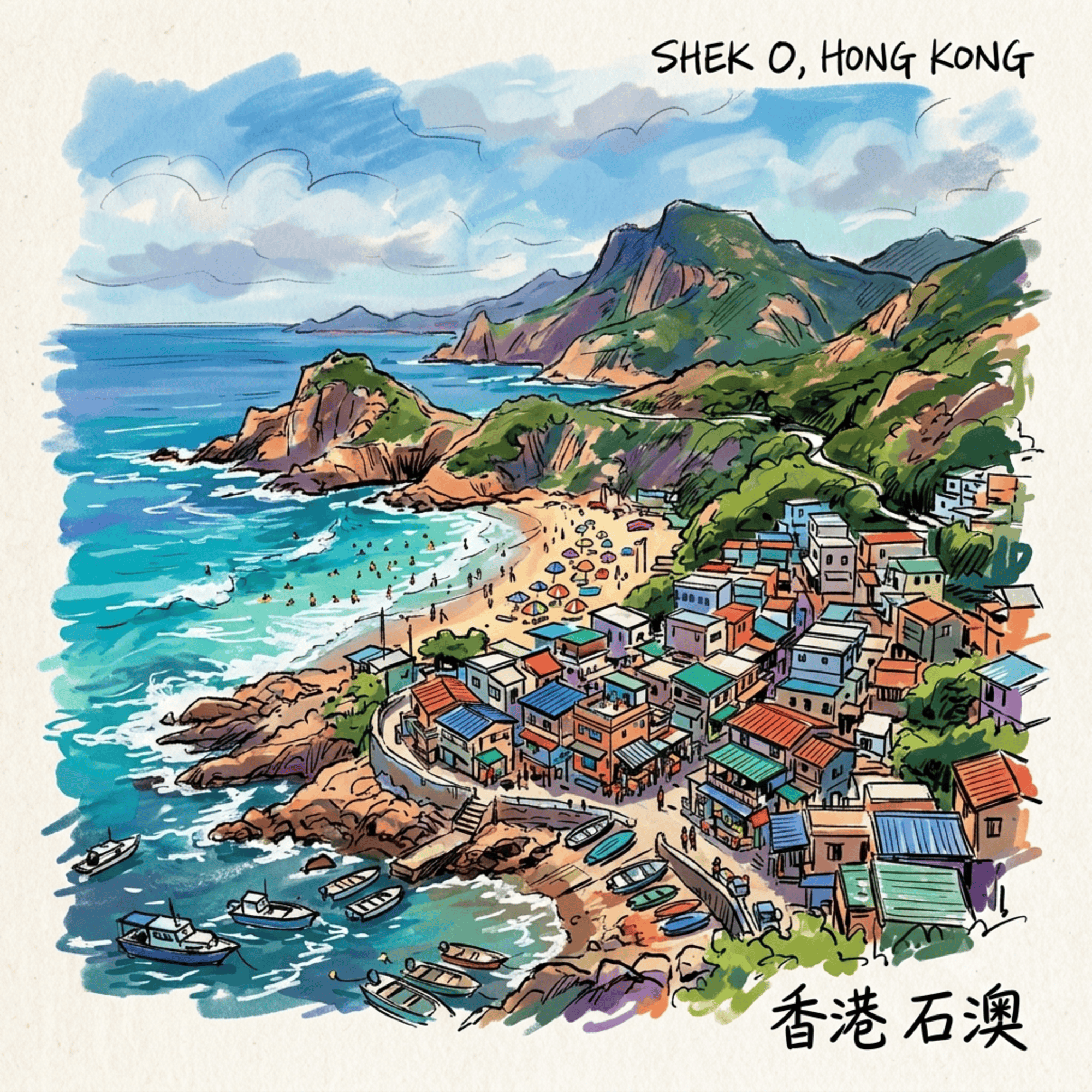
You take the 9 bus from Shau Kei Wan, wind down through the hills, and suddenly there it is — a crescent of white sand facing open sea, ringed by green headlands, improbably calm for a city of eight million. You find a spot. You order something cold. The afternoon passes pleasantly.
There is absolutely nothing wrong with this. Shek O is, by any measure, one of the finest beaches in East Asia.
But here is the thing most visitors never discover: in the course of a single afternoon, you have almost certainly walked past a rock carved three thousand years ago, strolled through a village that was forcibly relocated to make room for a European-only country club, and ignored a lighthouse that is older than the Eiffel Tower. Somewhere further down the peninsula, half-buried in subtropical undergrowth, are the ruins of two coastal gun batteries that were built in panic, fired almost never, and destroyed by their own builders in a matter of hours.
Shek O — the name means, simply, "rocky bay" — has been absorbing history for three millennia. It has never particularly advertised this fact.
Listen to the historical stories told in detail (For subscribers only)
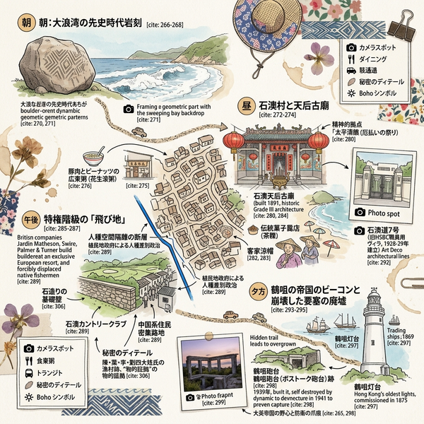
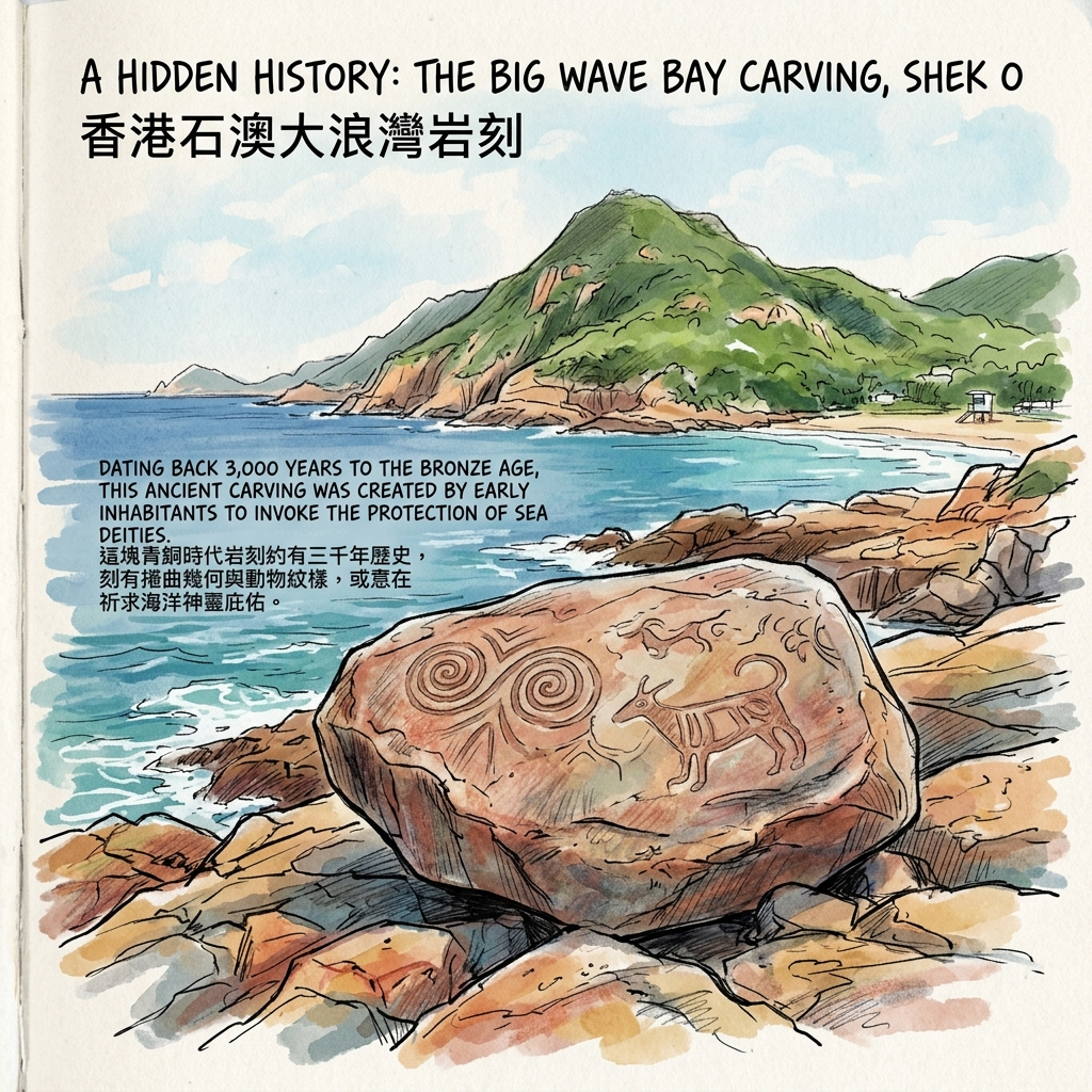
1. The Carving on the Rock Is Older Than the Roman Empire
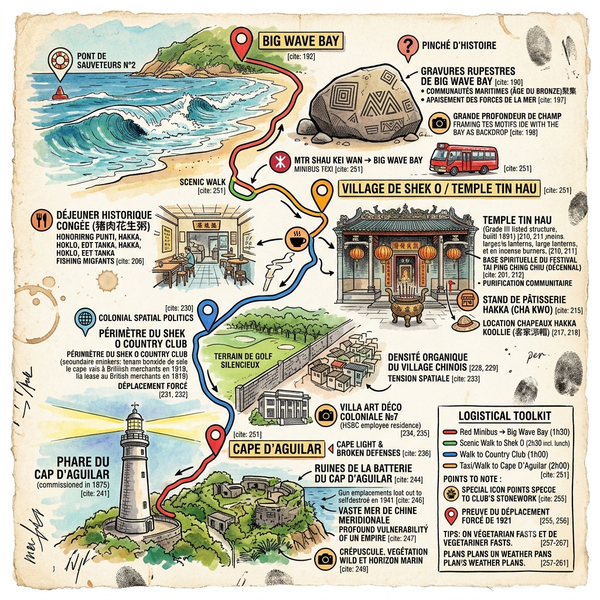
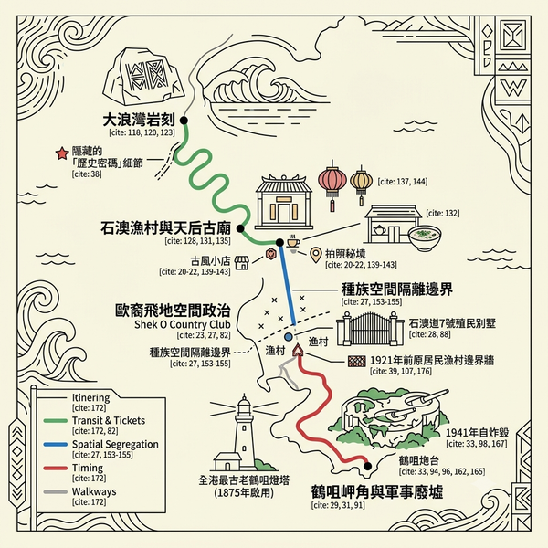
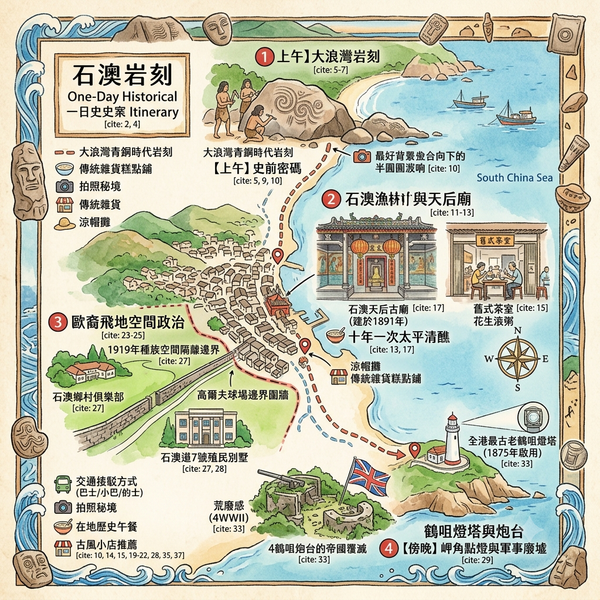
Walk north from Shek O beach toward Big Wave Bay. Past the second lifeguard station, a rough path dips toward the shoreline rocks. If you know what you are looking for, you will find it: a flat-faced boulder, roughly the size of a wardrobe laid on its side, covered in flowing geometric spirals and shapes that might be animals.
Most people walk straight past it.
The carving is approximately three thousand years old — Bronze Age, by the broad archaeological reckoning. It was noticed by a police officer on a routine patrol in 1970, formally declared a protected monument in 1978, and has been sitting quietly beside the South China Sea ever since. Hong Kong's Antiquities and Monuments Office describes the imagery in careful official language:
"The pattern shows very dynamic geometric and animal designs… Early inhabitants probably relied on the sea for their livelihood, and the rock carvings may have been intended to invoke the protection of sea deities."
There are nine of these rock carvings scattered across Hong Kong's coastline — on offshore islands, on headlands, on sea-facing boulders — and they share a strikingly consistent visual grammar. This is not the work of one isolated group scribbling on a local rock. It is evidence of a maritime culture that moved freely across what is now the northwestern coast of the South China Sea, speaking in symbols that researchers have linked to the decorative patterns on Bronze Age bronze vessels and geometric ceramics found across the broader Guangdong region.
The implication is worth sitting with. In 1841, when Britain established its colony here and the official story of Hong Kong effectively began, the rock at Big Wave Bay was already two thousand eight hundred years old. The standard narrative — that Hong Kong was a "barren rock" before the British arrived — is not just an oversimplification. It is flatly contradicted by this boulder, which was already ancient when Rome was a village.
There is also a longer thread worth following. If those spirals really did invoke sea deities, then the instinct they represent — carving a prayer into stone at the edge of the ocean — precedes by three millennia the Tin Hau temple that now stands at the center of Shek O village. The goddess is different; the impulse is the same. On this particular peninsula, the relationship between people, sea, and the supernatural has never really changed.
Finding it today: Follow the path north from Big Wave Bay beach, past the second lifeguard station. The carved boulder sits close to the shoreline — there is no interpretive sign, which is either charming or frustrating depending on your disposition. Overcast light works better than direct sun for making the carvings legible.
2. This Village Has Always Been a Negotiation Between Strangers
Shek O village is about two hundred years old, give or take. The founding families — Chan, Yip, Li, Lau — came from Guangdong province and settled on a bay that was, by any practical measure, inconvenient: too exposed for safe anchorage, too remote for easy commerce, too small to support anything beyond subsistence fishing. When the British surveyed their new colony in 1841, Shek O village, Hok Tsui village, and Tai Long Wan village combined had a recorded population of roughly two hundred people.
Those two hundred people were not a single community. They were four.
The Punti — Cantonese-speaking locals whose families had farmed and fished here for generations. The Hakka — a distinct ethnic group identifiable by language and custom, whose women wore distinctive broad-brimmed straw hats with hanging black fringes, and still do, if you look for them at the beach entrance on a weekday. The Hoklo — boat-dwelling fisherfolk from Fujian and Chaozhou, seasonally present, culturally distinct. And the Tanka, sometimes called the "boat people," who for centuries were barred from settling on land in much of Guangdong and who occupied the uneasy borderland between sea and shore.
Four communities. One small, exposed bay. No governing authority that paid them much attention.
What emerged, of necessity, was a set of informal arrangements that kept the peace. One of the more striking was a deliberate marriage policy: villagers sought partners from outside the immediate community — "even as far as Kowloon," as one account puts it — specifically to prevent grievances from calcifying along ethnic lines. This is the kind of pragmatic social engineering that never makes it into official histories, and probably shouldn't be romanticized. It was survival arithmetic, not multiculturalism. But it produced something genuinely unusual: a small, mixed community that held together across generations.
One of the things it held together through was language loss. A woman named Sara Ng, interviewed by a local magazine, recalled hearing Hoklo — the Fujian dialect — spoken in the village when she was a child. By the time she was an adult, it was nearly gone. The Hoklo people had depended on the sea for mobility, and Shek O's exposed bay made long-term mooring impractical. Without boats to return to, they drifted, and the language drifted with them.
Language death is usually invisible. This is one of the few cases where the mechanism is legible enough to trace.
Finding it today: The village is still lived in, which matters more than any single sight. Look for the women with the Hakka hats near the car park — they rent out beach umbrellas and represent, in the most mundane possible setting, a two-hundred-year cultural thread. Walk into the village lanes, past the small restaurants, and notice that the spatial layout — compact, organic, turned toward the sea — has the logic of something that grew rather than something that was planned.

3. In 1919, a Company of Forty-Four Englishmen Built a Club on Top of a Village
This is the part of Shek O's history that is most thoroughly buried, and most worth excavating.
In 1919, the colonial government granted land on the Shek O peninsula to British commercial interests for the development of a high-end leisure facility — one specifically intended for European residents. Two years later, the Shek O Country Club opened its golf course and clubhouse. The shareholders of the development company that built it numbered forty-four. Every single one was British.
Hong Kong's Antiquities Advisory Board, in its official appraisal of a colonial-era villa at 7 Shek O Road, records the purpose of the enterprise without euphemism:
"Shek O resort development was designed exclusively for Europeans."
The shareholders were not obscure figures. The list reads like a directory of colonial Hong Kong's commercial elite: men from Jardine, Matheson & Company — the trading house that had done more than perhaps any other to shape the colony's economic structure — alongside representatives of Butterfield & Swire, partners from the architectural firm Palmer and Turner, and lawyers from Messrs. Deacons. The development of Shek O as a white enclave was not a fringe project. It was a joint venture of the colony's most powerful institutions.
The problem was that people were already living where the golf course was going to be.
The original Shek O village — the fishing settlement whose founding families had arrived two centuries earlier — occupied the land on which the club was built. Its residents were relocated to the southern tip of the peninsula, to the site where today's village now stands. Existing records indicate that many were "dispossessed of their properties or shortchanged" in the process. The precise details — who negotiated, whether there was resistance, what was actually paid — are not in any public document. The archive is silent. That silence is itself a fact.
It is worth noting where Shek O sits in a wider pattern. In 1904, the colonial government had formalized the exclusion of Chinese residents from Victoria Peak. In 1919, a similar ordinance created a whites-only enclave on the hilltop of Cheung Chau island. Shek O followed the same logic, in the same year. These were not isolated decisions. They were a policy, repeated across the geography of the colony, incrementally and with legal precision.
The racial residency laws were abolished in 1946 — partly under the moral pressure of what had happened in Europe — but the spatial arrangements they created proved far more durable than the laws themselves.
Finding it today: Stand at the entrance to Shek O village and look toward the Country Club's perimeter wall. The wall approximately marks the boundary of where the original village stood. The present village is on the other side of it — the rebuilt community of people who were moved. The distance between the two is a five-minute walk. The club remains private; non-members cannot enter. The exclusion, you might observe, has a long habit.

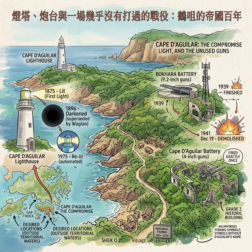
4. The Lighthouse Was Built in the Wrong Place, and the Guns Were Built Too Late
At the far end of the Shek O peninsula — about forty-five minutes on foot from the village, along a road that passes through dense subtropical greenery and then opens suddenly onto sea — stands a white stone lighthouse.
It is the oldest lighthouse in Hong Kong. It is still operational. It went dark for nearly eighty years and hardly anyone noticed.
The Cape D'Aguilar Lighthouse — Hok Tsui Beacon, in Cantonese — was lit for the first time on 16 April 1875. The timing was commercial: the Suez Canal had opened six years earlier, dramatically shortening the route between Europe and East Asia, and Hong Kong's port was handling traffic it had not previously imagined. Ships needed guidance. The colonial government needed a lighthouse.
The honest truth is that the D'Aguilar headland was not the first choice. The government had already identified better locations — Waglan Island, Gap Rock, the Lema Islands — but these lay outside Hong Kong's territorial waters and could not be built upon. Hok Tsui was the compromise. It was where they could reach.
The lighthouse served for twenty-one years before being superseded by Waglan Island Lighthouse in 1893 — a better-positioned structure that remains the primary maritime beacon for vessels approaching Hong Kong to this day. Cape D'Aguilar's light was extinguished in 1896. The lens was removed and shipped elsewhere. The building stood, unused, until 1975, when it was re-lit as an automated navigation aid.
The lighthouse was named for Major-General Sir George Charles D'Aguilar, who served as Lieutenant Governor of Hong Kong from 1843 to 1848. He is, in most respects, a minor figure in colonial history — significant enough at the time, but not especially remembered. His name lives on primarily in two forms: the headland, and the lighthouse. The fishing families of Hok Tsui village who lived on this land long before the lighthouse was built have no such memorial.
Then came the guns.
In 1939, with war in Europe and Japan already occupying large swaths of China, the colonial government built two coastal batteries on the D'Aguilar peninsula. Bokhara Battery, positioned near the lighthouse, was equipped with two 9.2-inch guns — heavy coastal artillery capable of reaching targets far out to sea. Cape D'Aguilar Battery, lower down the headland, carried 4-inch guns for closer-range defense.
On 8 December 1941, Japan attacked Hong Kong simultaneously with its assault on Pearl Harbor. The British defense collapsed faster than almost anyone had anticipated. By 19 December, the East Brigade was retreating toward Stanley, and Royal Engineers were demolishing the Hok Tsui guns to prevent their capture. Historical accounts note that Cape D'Aguilar Battery had faced the enemy exactly once before it was destroyed.
Once.
The batteries had taken years to plan and build. They lasted, in combat terms, eleven days. The ruins of Bokhara Battery remain on the headland, partly obscured by the infrastructure of a telecommunications transmitter that now occupies the same site. Cape D'Aguilar Battery — a Grade 2 historic building — survives more completely, its gun pits and observation posts still readable in the landscape for anyone willing to push through the undergrowth.
The history of military failure tends not to be prominently commemorated. These ruins were never given interpretive signs.
Finding it today: Take the walking path from Shek O village past the Shek O Country Club and continue along the Hok Tsui road to its end (about 45 minutes). The lighthouse grounds are accessible on foot but the interior is closed. Cape D'Aguilar Battery requires a scramble down a side path toward the water; wear shoes you don't mind muddying. Bokhara Battery is easier to reach, though much of the original structure has been absorbed into the telecommunications site. Look for the gun emplacements: platforms of concrete, angled toward open sea, pointed at a threat that arrived from a different direction entirely.
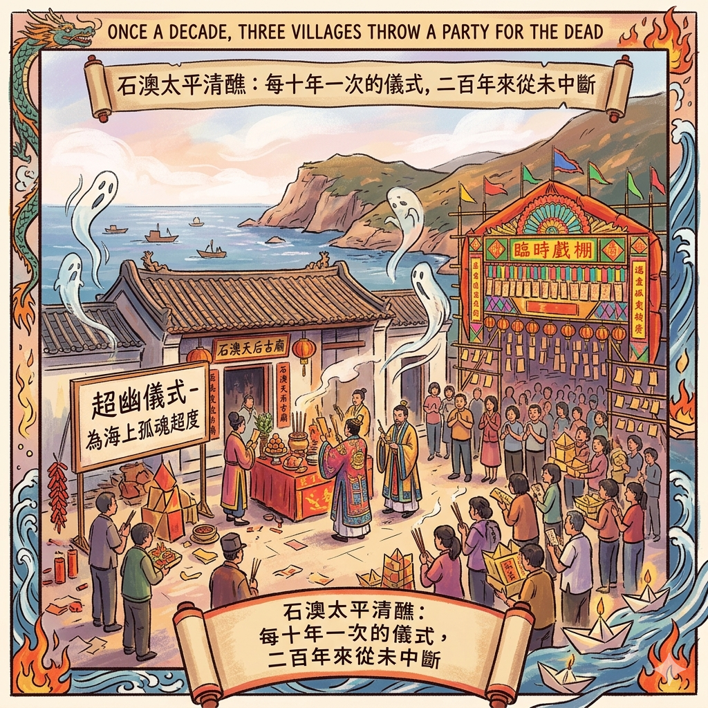
5. Once a Decade, Three Villages Throw a Party for the Dead
Every ten years, Shek O holds a ritual that most people in Hong Kong have never witnessed, and that the fishing communities of this peninsula have been performing, in some form, for at least two centuries.
It is called the Tai Ping Ching Chiu — loosely, a "festival of great peace and purification" — and it belongs to a tradition of Daoist communal rites practiced across the coastal communities of Guangdong and Fujian. The most famous version of this kind of festival in Hong Kong is the Bun Festival on Cheung Chau island, which happens annually and draws enormous tourist crowds. Shek O's version happens every decade, is considerably less publicized, and in some ways runs deeper.
Three villages co-host: Shek O, Tai Long Wan, and Hok Tsui. Together they commission Daoist priests, erect temporary bamboo theaters, hang thousands of paper offerings, and work through a sequence of ritual procedures that lasts several days. The structure includes prayers, penitential rites, the invocation of protective deities — and one ceremony that is easily the most historically resonant of all.
It is called chiu yau, sometimes translated as "salvation of the wandering souls."
In it, the priests formally address — and ceremonially release — the spirits of people who died at sea without proper burial rites. For a fishing community in the nineteenth or early twentieth century, this was not an abstraction. Men went out and did not come back. Bodies were not always recovered. The dead accumulated, unaddressed, and the living carried that weight.
The chiu yau was, in functional terms, a communal grief ritual. A collective reckoning with the specific kind of loss that comes from making your living on the water. It survives in Shek O today — transposed into a contemporary context in which almost no one in the village fishes for a living anymore — as something between cultural memory and genuine belief, depending on who you ask.
The academic record here is precise. In 1986, a University of Hong Kong scholar named Chan Wing-Hoi attended the Shek O festival and published his observations in the Journal of the Hong Kong Branch of the Royal Asiatic Society, Volume 26. It remains the most detailed scholarly documentation of this particular tradition, covering the ritual sequence, the social organization of participation, and the theological texts used by the officiating priests. If you want to understand what actually happens during these days, it is the place to start.
What is equally worth noting is the social architecture of the event. The three-village co-sponsorship is not incidental. It reflects the web of kinship, shared fishing grounds, and mutual obligation that has connected Shek O, Hok Tsui, and Tai Long Wan for generations. The cross-village marriage strategies mentioned earlier — choosing partners from neighboring communities specifically to prevent inter-village resentment — are part of the same system. The festival is the ritual expression of an alliance that was built out of practical necessity and has outlasted the necessity.
The Tin Hau Temple at the center of Shek O village — built in 1891, dedicated to the Goddess of the Sea who is the spiritual anchor of fishing communities across southeastern China — is the fixed point around which all of this orbits. Tin Hau (also known as Mazu in Mandarin) is a Song Dynasty figure from Fujian who, according to tradition, possessed the ability to calm storms and guide lost sailors. She is worshipped at hundreds of temples along the Chinese coast, and at dozens more across Southeast Asia and wherever the Chinese maritime diaspora settled. The Shek O temple is modest, unhurried, and almost never crowded.
Shek O is, incidentally, the only place on Hong Kong Island that still holds a regular jiao — this type of Daoist communal purification festival. The others disappeared as the city grew around them, swallowing the fishing villages and the traditions they carried. Shek O's geography — the same remoteness that made it easy to displace for a golf club, that made it a logical place for a second-rate lighthouse, that made its gun batteries seem adequate until they suddenly weren't — also protected it from the particular kind of erasure that comes with urban development.
Finding it today: Shek O Tin Hau Temple is in the heart of the village, a short walk from the car park. It's small enough to miss if you're not looking. Go inside; let your eyes adjust to the incense smoke. The decade-festival Tai Ping Ching Chiu next occurs on a cycle roughly ten years from the last — check the Shek O Residents' Association for precise dates. If you can be there for it, you should. Very few experiences available in Hong Kong carry this much unbroken historical weight.
Hidden in Plain Sight: Two More Places Worth Knowing
Cape D'Aguilar Marine Reserve is Hong Kong's only legally designated marine reserve, managed by the University of Hong Kong's Swire Institute of Marine Science. What makes it worth seeking out is not the marine biology (though that is significant) but the geology: a sea cave called Thunder Cave and its companion rock formation known locally as Crab's Eye are accessible at low tide and represent the kind of ancient coastal landscape that the peninsula has been shaped by for millions of years. The research station also houses the skeleton of a whale called Miss Willy — an unlikely artifact that gives the place a pleasantly eccentric quality.
Tai Long Wan Village — the smallest of the three Tai Ping Ching Chiu co-hosting communities — is a ten-minute walk from Shek O and receives almost no visitors. A handful of houses, a small shrine, the specific quality of silence that comes from a place that the twenty-first century has not quite decided what to do with. Worth an hour of anyone's time.
A Walk Through Time: Following the Layers
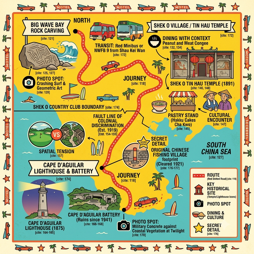
The most useful way to approach Shek O is chronologically. The place deposits its history in layers, and walking through them in sequence produces a different kind of understanding than visiting any single site.
Start at Big Wave Bay (c. 1000 BCE): Find the Bronze Age carving before the beach fills up. Stand next to it and understand that you are at the beginning of a three-thousand-year story.
Walk to Shek O Tin Hau Temple (1891): Enter the village. Find the temple. Consider that the sea-deity tradition it embodies is, in some sense, continuous with what was carved on the boulder two and a half miles away.
Stand at the Country Club wall (1919–1921): The wall marks the approximate extent of the original village. The current village is on the other side of it. The distance between dispossession and replacement is walkable.
Follow the road to Hok Tsui (1875–1941): Forty-five minutes on foot. Lighthouse, gun emplacements, scattered ruins. An empire's infrastructure cycle — built for commerce, adapted for war, abandoned in defeat — compressed into one headland.
Total walking distance is roughly 8–10 kilometers. Bring water. Give yourself a full day.
What Kind of Place Is This, Really?
Five stories, three thousand years, one peninsula.
What connects them is not simply geography. It is something more like the recurring logic of a marginal place — a location far enough from the center to be useful as a dumping ground (for displaced fishermen, for second-best lighthouses, for gun batteries that nobody really expected to work) and far enough from the center to escape the homogenizing pressure of the city.
The Bronze Age carvers left their marks here precisely because this headland faced open water. The fishing families settled here because nobody more powerful wanted it yet. The colonial leisure class claimed it because its remoteness made exclusivity easy to enforce. The military planners stationed guns here because the geography demanded it. The fishing communities kept their rituals alive here because the developers never quite got around to them.
The same quality — being on the edge — produced all five outcomes. Whether that quality is an advantage or a vulnerability depends entirely on who is asking, and when.
This is, when you think about it, a description of a great many places. The interesting question is not whether Shek O is unique in this pattern, but whether the pattern is visible once you know where to look. Most places have a version of this stratigraphy — layers of use and abandonment and reinvention, stacked on top of each other, readable if you know what era you're standing in.
Shek O's gift is that it has compressed three thousand years of that process into a peninsula small enough to walk across in an afternoon.
The question worth sitting with, on the bus back to the city, is this: how many places have you visited without knowing what you were standing on?
Keep Reading
If Shek O has sharpened your interest in Hong Kong's layered colonial history, you might want to explore our guide to [Stanley and the wartime history of the Southern District], or follow the [colonial-era walking routes across Hong Kong Island's mid-levels]. For a broader frame, [Hong Kong Island's historical travel guide] covers the full arc from Qing-dynasty fishing settlements to the handover of 1997.
If this kind of reading — places understood through their history rather than their highlights — is what you come here for, subscribe to the Historical Travel Stories newsletter. Once a month, a location most people walk past without knowing what they're missing.
Getting There: The Practical Part
By Public Transport
Shek O is straightforward to reach without a car — and arriving this way is actually better, since it forces a moment of arrival rather than the slight unreality of driving directly into a car park.
Take the MTR Island Line to Shau Kei Wan (Cantonese: Siu Kei Wan), Exit A3. From the bus terminus just outside the station, board Citybus Route 9 to Shek O. Journey time is around 30 to 40 minutes. The road in is spectacular — narrow, cliff-edged, winding through country park — and worth looking up from your phone for.
For Hok Tsui (Cape D'Aguilar): the same Route 9 stops at Windy Gap (also called Shek O Road/Windy Gap), from where a road leads down to the lighthouse. The road is gated against general traffic — residents and licensed vehicles only — so plan to walk. One way on foot is approximately 45 minutes; the road is paved throughout.
Driving and Parking
Parking at Shek O beach is limited and fills quickly on weekends and public holidays. On busy days, parking in Shau Kei Wan and busing in is not just more practical — it also sidesteps the forty-minute traffic creep that can turn the return journey into a minor ordeal.
Where to Stay
There are no hotels in Shek O village itself. The nearest options worth considering:
Stanley (Chek Chue), fifteen minutes west by car, has a range of boutique hotels and serviced apartments and is itself historically rich — the site of the most significant WWII fighting on Hong Kong Island, and home to the Stanley Military Cemetery, which is among the most moving sites in the territory. Staying here makes it easy to combine both areas.
Causeway Bay or Wan Chai, on the northern shore of Hong Kong Island, puts you about twenty minutes by MTR and bus from Shau Kei Wan. A good base if you want access to both the historical southern coast and the commercial and cultural density of the city center.
Tsim Sha Tsui, across the harbor in Kowloon, is Hong Kong's traditional hotel district and offers the widest range of accommodation at every price point. The commute to Shek O is about an hour door-to-door, which is manageable for a day trip.
Guided Options
Antiquities and Monuments Office (AMO) periodically offers open days and guided visits to protected heritage sites, including monuments on the D'Aguilar peninsula. Check the AMO website in advance; these events are worth planning a trip around.
Walk in Hong Kong and similar local heritage tour operators offer customized walking routes covering colonial history, WWII sites, and traditional village culture across Hong Kong Island's southern districts. Worth booking if you'd rather have the context delivered in real time.
Tai Ping Ching Chiu: The Shek O Da Jiu festival occurs on a ten-year cycle. Confirm exact dates with the Shek O Residents' Association before planning a visit around it. The procession from Shek O to Tai Long Wan is open to the public — no invitation needed, minimal English signage, entirely worth the effort.
Best Time to Visit
Autumn and early winter — October through February — offer the most comfortable walking weather, with lower humidity and clearer skies. This is also when Tin Hau's annual birthday celebrations take place at the village temple (usually around the 23rd day of the third lunar month, which falls in April or May — confirm the exact date each year). The beach is usable year-round, though the water temperature peaks between June and September, which is also peak typhoon season.
Q & A
How do the diverse local ethnic groups maintain their shared identity?
The diverse local ethnic groups in Shek O—primarily the Punti (Cantonese), Hakka, Hoklo, and Tanka—maintain their shared identity through a combination of religious rituals, strategic social practices, and a common livelihood rooted in their unique geographic setting.
According to the sources, the following mechanisms are central to their shared identity:
1. Joint Religious Rituals as "Social Glue"
The most powerful integrating force is the Tai Ping Ching Chiu (Peace Festival), held every ten years,.
- Three-Village Cooperation: The festival is jointly organized by Shek O, Tai Long Wan, and Hok Tsui villages. This "three-village joint ritual" (三村聯醮) confirms and strengthens the identity of these geographically and historically linked settlements.
- Cross-Ethnic Participation: The organization of the ritual is described as the most effective adhesive for the community, as all residents fund and participate in the festivities regardless of their ethnic background (whether they are Tanka, Hakka, or even foreign residents),.
- Shared Spiritual Space: The Tin Hau Temple, established in 1891, serves as a tangible platform for cross-ethnic cooperation, where managing temple affairs and celebrations reinforces their collective identity.
2. Strategic Social Policies (Intermarriage)
Because Shek O was a multi-ethnic community rather than one dominated by a single lineage, internal harmony was vital,.
- Avoiding Grudges: To prevent local frictions and resource competition, villagers historically practiced strategic cross-village intermarriage, sometimes finding spouses as far away as Kowloon. This prevented any single local group from becoming too insular or antagonistic toward others.
3. Shared Economic Foundation
- Common Livelihood: Fishing provided a shared economic base for the different groups. This common way of life created a mutual understanding and shared risks, which later provided the foundation for their collective religious life.
- Collective Psychological Support: The ritual of "Chao You" (supernatural salvation for those lost at sea) addressed the shared anxiety of high-risk maritime labor, providing a systematic way for the entire community to process trauma and death.
4. Geographic Marginality
The "remoteness" of the Shek O peninsula acted as a protective shield. Its distance from the main administrative centers allowed these diverse groups to form a relatively autonomous community where they had to rely on one another rather than external authorities, fostering a "multi-ethnic community" identity that has persisted for over two centuries.
How did strategic intermarriage help maintain communal harmony?
In the multi-ethnic community of Shek O, strategic intermarriage served as a vital social adjustment mechanism to prevent internal friction and ensure long-term stability among the diverse groups living in close proximity.
According to the sources, this practice contributed to communal harmony in several key ways:
- Preventing Local Grudges: Because Shek O was a small, isolated settlement composed of different ethnic groups—including the Punti, Hakka, Hoklo, and Tanka—there was a high potential for daily friction and competition over limited resources. Villagers consciously practiced cross-village intermarriage, sometimes seeking spouses from as far away as Kowloon, specifically to "avoid generating grudges among local ethnic groups".
- Neutralizing Internal Tensions: By bringing in spouses from outside the immediate community rather than marrying exclusively within the village, the residents prevented any single local family or ethnic faction from becoming too dominant or insular, which helped maintain a balanced social fabric.
- Fostering Inter-Village Interdependence: This strategy extended beyond individual families to the broader "three-village" network of Shek O, Tai Long Wan, and Hok Tsui. The "close marriage" ties created a long-term interdependence between these settlements, which complemented their shared reliance on fishing resources and collective religious activities.
Ultimately, these strategic marital alliances acted as a social safeguard, allowing a diverse "multi-ethnic community" to function cohesively for over two centuries despite the pressures of their marginal and isolated geographic environment.
Reference and Further reading
First layer: Primary sources and institutional origins
- 香港古物古蹟辦事處(AMO)——《大浪灣岩刻》法定古蹟官方說明,文件編號 Monuments_01,香港島系列
- 香港古物古蹟辦事處——《鶴咀岩刻》法定古蹟官方說明,文件編號 Monuments_121(2018年新發現)
- 香港政府憲報——《古物及古蹟條例》(Antiquities and Monuments Ordinance,Cap. 53)法定古蹟名冊
- 漁農自然護理署(AFCD)——石澳郊野公園官方地質及生態記錄
- 香港政府公共紀錄處(Public Records Office,PRO)——1841年香港島人口調查記錄(含石澳、鶴咀、大浪灣三村登記資料)
- 香港房屋委員會及地政總署——石澳地區原有鄉村土地地契及地段歷史紀錄(需進一步核查)
- 香港歷史博物館——廣東沿岸族群移民史展覽相關文獻
- 香港古物諮詢委員會(AAB)——《石澳道7號歷史建築評估》(Historic Building Appraisal No. 913,全文英文),含石澳開發公司股東名單及建築史
- 香港公共紀錄處(PRO)——殖民地土地批租記錄,1919-1930年代石澳相關地段
- 香港政府憲報——歷史土地政策公告及相關法規(建議核查1919年前後石澳土地相關公告)
- 香港立法機關——殖民地種族隔離相關法令的歷史立法記錄
- 香港古物古蹟辦事處(AMO)——《鶴咀燈塔》法定古蹟官方說明(Monuments_80),含燈塔完整建造及運作歷史
- 香港皇家遊艇會(RHKYC)歷史研究項目——"Cape D'Aguilar Lighthouse"(含燈塔點燈歷史及菲涅爾透鏡移運記錄)
- 英國殖民部(Colonial Office)檔案——CO 129系列,香港防禦相關文件(存於英國國家檔案館/TNA,建議系統查閱)
- 英國國家檔案館(TNA)——香港保衛戰(Battle of Hong Kong)官方軍事報告,1941年12月
- 香港古物古蹟辦事處(AMO)——石澳天后廟歷史建築評估及宗教物質文化記錄
- 香港非物質文化遺產辦事處——打醮(Dajiao)及漁村天后信仰相關記錄(部分已列入香港非物質文化遺產名錄)
- 香港歷史博物館——廣東漁業社群宗教信仰展覽文獻
- 香港多媒體記憶計劃(Hong Kong Memory)——「長洲太平清醮的由來」及相關漁村醮節資料
Second layer: Secondary academic literature
- Meacham, W.(1980年代至1990年代)——香港岩刻綜合研究(建議核查其在《香港皇家亞洲學會學報》/JHKBRAS的相關論文)
- Bard, S.M.(1988)——In Search of the Past: A Guide to the Antiquities of Hong Kong,香港市政局出版
- 建議進一步核查:香港中文大學中國考古藝術研究中心及香港大學考古系關於香港史前岩刻的正式考古報告
- Faure, D.(1986)——The Structure of Chinese Rural Society: Lineage and Village in the Eastern New Territories,牛津大學出版社(提供宗族組織的比較框架)
- Watson, R.S. & Watson, J.L.(2004)——Village Life in Hong Kong: Politics, Gender, and Ritual in the New Territories,香港中文大學出版社
- Cheung Kwok-hung, Stephen——關於香港客家歷史與文化的學術研究(見Zolima City Magazine引述)
- Lai, L.W.C. & Yu, B.T.(2001)——"The Question of Discrimination in Real Estate Zoning in Colonial Hong Kong," Environment and Planning B, 28, pp. 295-314
- Lai, L.W.C.(2011)——"Discriminatory Zoning in Colonial Hong Kong: A Review of the Post-War Literature and Some Further Evidence for an Economic Theory of Discrimination," Property Management, 29(1), pp. 50-86
- Chu, C.L.(2022)——Building Colonial Hong Kong: Speculative Development and Segregation in the City, Routledge(提供殖民地空間隔離的系統性學術框架)
- Miners, N.(1987)——Hong Kong under Imperial Rule, 1912-1941, Oxford University Press
- Lindsay, O.(2005)——The Lasting Honour: The Fall of Hong Kong, 1941, Pen & Sword Military(詳細敘述1941年保衛戰的東旅部署)
- Banham, T.(2003)——Not the Slightest Chance: The Defence of Hong Kong, 1941, University of British Columbia Press
- Warfare History Network(2024)——"Heroic Defense of Hong Kong"(含鶴咀9.2英寸炮被炸毀的文字記錄)
- Chan, Wing-Hoi(1986)——"Observations at the Jiu Festival of Shek O and Tai Long Wan, 1986," Journal of the Royal Asiatic Society Hong Kong Branch, Vol. 26, pp. 78-101(本故事最核心的一手學術田野記錄)
- Choi, C.C.(1990)——"Studies on Hong Kong Jiao Festivals," Journal of the Royal Asiatic Society Hong Kong Branch, Vol. 30, pp. 26-43
- Chan, Wing-Hoi(1989)——"The Dangs of Kam Tin and Their Jiu Festival," Journal of the Royal Asiatic Society Hong Kong Branch, Vol. 29, pp. 302-375(提供香港打醮傳統的比較框架)
- Watson, R.S. & Watson, J.L.(2004)——Village Life in Hong Kong: Politics, Gender, and Ritual in the New Territories
Third layer: Supplementing the meridians
- Localiiz(2021)——"Hong Kong's Most Interesting Ancient Rock Carvings"(含William Meacham引述)
- 香港旅遊發展局——大浪灣官方景點說明(作為大眾媒介參考,非學術來源)
- Zolima City Magazine(2016年)——"Why Close-Knit Shek O Erupts in Celebration Once Every Ten Years"(含Sara Ng口述及族群構成田野記錄)
- SCMP(2016年)——"Uncertain Origins of Hong Kong's Tanka People"(提供蜑家族群的比較歷史脈絡)
- PeakVisor(2021)——《石澳郊野公園》(含「1920年代殖民政府將土地批予英商建立歐裔休閑設施,許多村民被剝奪財產或遭不公平補償」的明確記載)
- Zolima City Magazine(2022)——"Hong Kong's Other Peak"(提供長洲種族隔離的比較案例,有助理解石澳的同期背景)
- Hong Kong Free Press(HKFP,2021年)——"HKFP Guide: Hong Kong's Cape d'Aguilar"(含博哈拉炮台及鶴咀炮台的田野記述)
- Industrial History of Hong Kong Group(2015年)——"Waglan Island Lighthouse"(提供燈塔系統的技術比較脈絡)
- "Battle for Hong Kong" 歷史博客(2014年)——含鶴咀軍事存在的讀者田野回憶(需謹慎對待,建議以一手軍事檔案核查)
- Zolima City Magazine(2016年)——"Why Close-Knit Shek O Erupts in Celebration Once Every Ten Years"(含田野觀察及口述記錄)
- Zolima City Magazine(年份待核)——"A Close Look at Hong Kong's Rare, Extravagant Spiritual Purification Festivals"(含太平清醮的結構性解說)
- Hong Kong Travel Blog(2016年)——"Shek O Da Jiu Festival"(含三村聯辦及飄色巡遊的基本記述)


Historical sources for this article include the Antiquities and Monuments Office of Hong Kong (official scheduled monument records for Big Wave Bay and Cape D'Aguilar Lighthouse), the Antiquities Advisory Board Historic Building Appraisal No. 913 (7 Shek O Road), Chan Wing-Hoi's 1986 fieldwork published in the Journal of the Hong Kong Branch of the Royal Asiatic Society, Tim Banham's Not the Slightest Chance (UBC Press, 2003), and the published research of Lawrence Lai on discriminatory zoning in colonial Hong Kong. Readers seeking primary sources should contact the Hong Kong Public Records Office and the library of the Royal Asiatic Society Hong Kong Branch.