Beyond the Garden City: Decoding the Spiritual Layers of Tokyo’s Higashi-Chofu-machi
Discover the hidden history of Tokyo’s Higashi-Chofu-machi and Den-en-chofu. This walking guide uncovers 5 historic layers beneath the prestigious Garden City—from ancient burial mounds along the cliff line and samurai outposts to Edo-era waterworks and modern urban design.

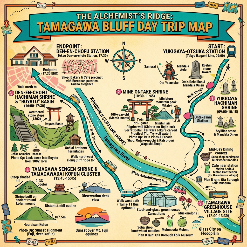
This is a historical travel story and walking guide to Higashi-Chofu-machi, an area encompassing Den-en-chofu, Yukigaya, and Mine-machi in southwestern Tokyo. Traversed along the edge of the Kunibunji cliff line, the walk explores ancient burial mounds, vanished river ports, feudal engineering, and early 20th-century urban planning. Readers will discover how millennia of sacred alignments, military outposts, and spiritual buffers transformed this landscape into Tokyo’s most iconic suburban enclave.
 Lawrence
The Liminal Edge of the Musashino Plateau
To the casual observer, the southwestern reach of Tokyo’s Ota Ward—modern Den-en-chofu, Yukigaya, and Mine-machi—is defined by the orderly elegance of its "Garden City" planning. However, beneath this modern veneer lies a complex spatial palimpsest. This region is geologically defined by the Hake, the Kunibunji cliff line where the high ground of the Ebara Plateau drops precipitously toward the Tama River’s flood-prone plains. Historically, this edge has served as a liminal boundary—a literal and spiritual threshold between the plateau’s order and the river’s chaos. For two millennia, the residents of the area once known as Higashi-Chofu-machi have mediated this boundary, constructing a landscape where life and death, military vigilance, and religious mimicry intersect. By walking these streets, one does not merely traverse a neighborhood; one navigates a two-thousand-year-old "spiritual energy buffer" designed to transform environmental and political trauma into a sacred, orderly geometry.
Listen to the historical stories told in detail (For subscribers only)
1. The Obsidian Axis: Kofun Clusters and the Geometry of Fuji
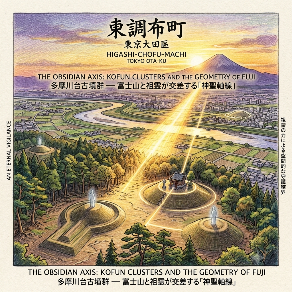
The ancient inhabitants of the Tama River basin did not view the plateau’s edge as mere real estate; they saw it as a platform for eternal vigilance. Between the 4th and 7th centuries, local ruling clans constructed the Ebara Plateau Kofun group—a series of burial mounds positioned at strategic high points. These mounds were not isolated tombs but physical "anchors" of power. By placing their ancestors atop the Hake, the ruling elite created a permanent visual claim over the water routes and agricultural lowlands below.
The most striking feature of this ancient topography is the alignment between the Tamagawadai Kofun group and the sacred geography of Japan. The Tamagawa Asama Shrine, which is built directly upon an ancient circular burial mound, aligns its primary axis with the Hōraizan Kofun and the distant silhouette of Mount Fuji.
Tokyo's Bulldozed Cosmic Calendar
The "So What?" Layer: This is more than a scenic view; it is a "spiritual corridor." In the indigenous worldview, this alignment connected the ancestors (the Kofun), the goddess of the volcano (Konohanasakuya-hime), and the river’s life-giving waters. During the equinoxes, the sun sets directly behind Mount Fuji, its light cutting through the burial mounds to bridge the world of the living on the plateau with the Tokoyo-no-kuni (the world beyond) across the river.
Kofun Name | Type | Dimensions | Archaeological Findings | Current Status |
Hōraizan | Keyhole-shaped | 107.5m (Length) | Four-beast mirrors, jasper spindles, iron tools | Preserved in Tamagawadai Park |
Nishioka No. 22 | Round | 4.5m (Height) | Iron arrowheads, short swords, straight swords | Within Tokoin Temple/Den-en-chofu Hachiman Shrine |
Nishioka No. 47 | Round | 30m (Diameter) | Fuki-ishi (paving stones), pottery fragments | Lost (demolished 1956 for parking) |
Sensory Experience: Climbing toward the Tamagawadai lookout, the urban heat of Tokyo suddenly yields. Under the dense canopy of the cliff-line vegetation, the temperature drops by 2 to 3 degrees Celsius. The air becomes heavy with the scent of damp loam and ancient pine, carried by the humid breeze rising from the Tama River. Standing on the hardened loam of a former mound, one feels the silence of the "ancestral sentinel" looking out over the plain.
2. The Sentinel’s Shadow: From Kamakura Port to Martial Shrine
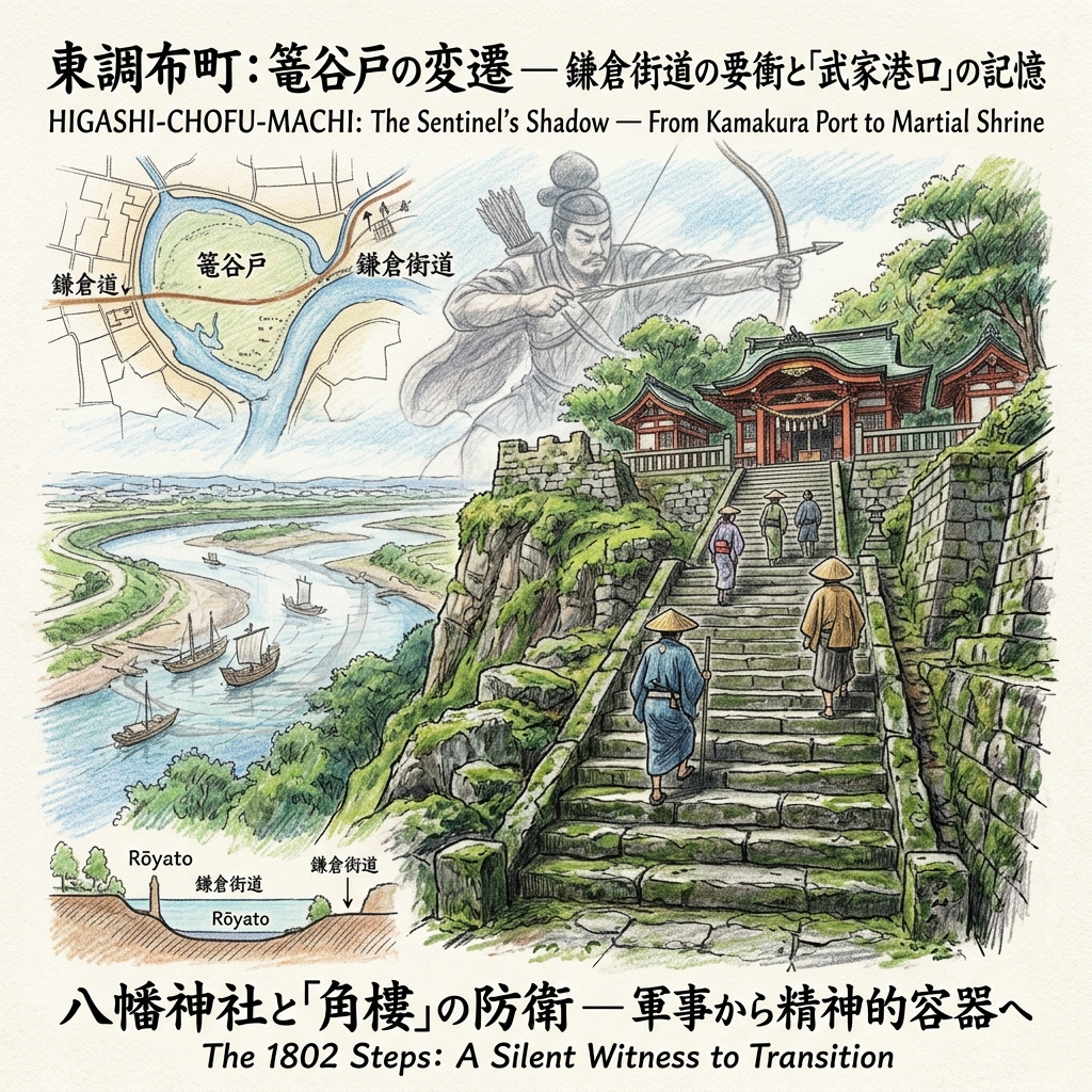
During the Kamakura period (1185–1333), the strategic value of the Hake shifted from the spiritual to the military. At the "Rōyato" basin, the Tama River once curved inland, forming a deep-water natural port. To control this vital node where the Kamakura Highway met the water, military outposts were established on the protruding plateau edges.
Following the fall of the Odawara Hojo clan in 1590, the Ochiai brothers—warriors under the command of Hojo Ujiteru, Lord of Hachioji Castle—arrived at the site of one such abandoned outpost. Seeking refuge, they did not simply build a home; they established the Den-en-chofu Hachiman Shrine. By enshrining Hachiman (the deity of war) on the ruins of a fortress, they transitioned the site from a place of conflict to a vessel for communal healing and post-war spiritual stability.
Tokyos Vanished Port
The "So What?" Layer: The shrine’s location is a masterclass in military feng shui. Situated on a peninsula-like protrusion overlooking the river, the site acts as a natural "bastion" (角樓). Using the Hachiman deity as a spiritual "lock" on this gateway space, the samurai sought to seal the "portal" through which both enemies and seasonal floods might enter the village's orderly world.
The 1802 stone steps of the Hachiman Shrine remain a silent witness to this transition. Weathered by two centuries of rain, the steps are now uneven, their edges softened by deep green lichen and moss. To climb them is to feel the weight of the Edo-period pilgrims who sought the protection of a warrior-god in an era of peace.
3. The Rebel’s Mandala: Ota Yasusuke and the Buried Prophecy
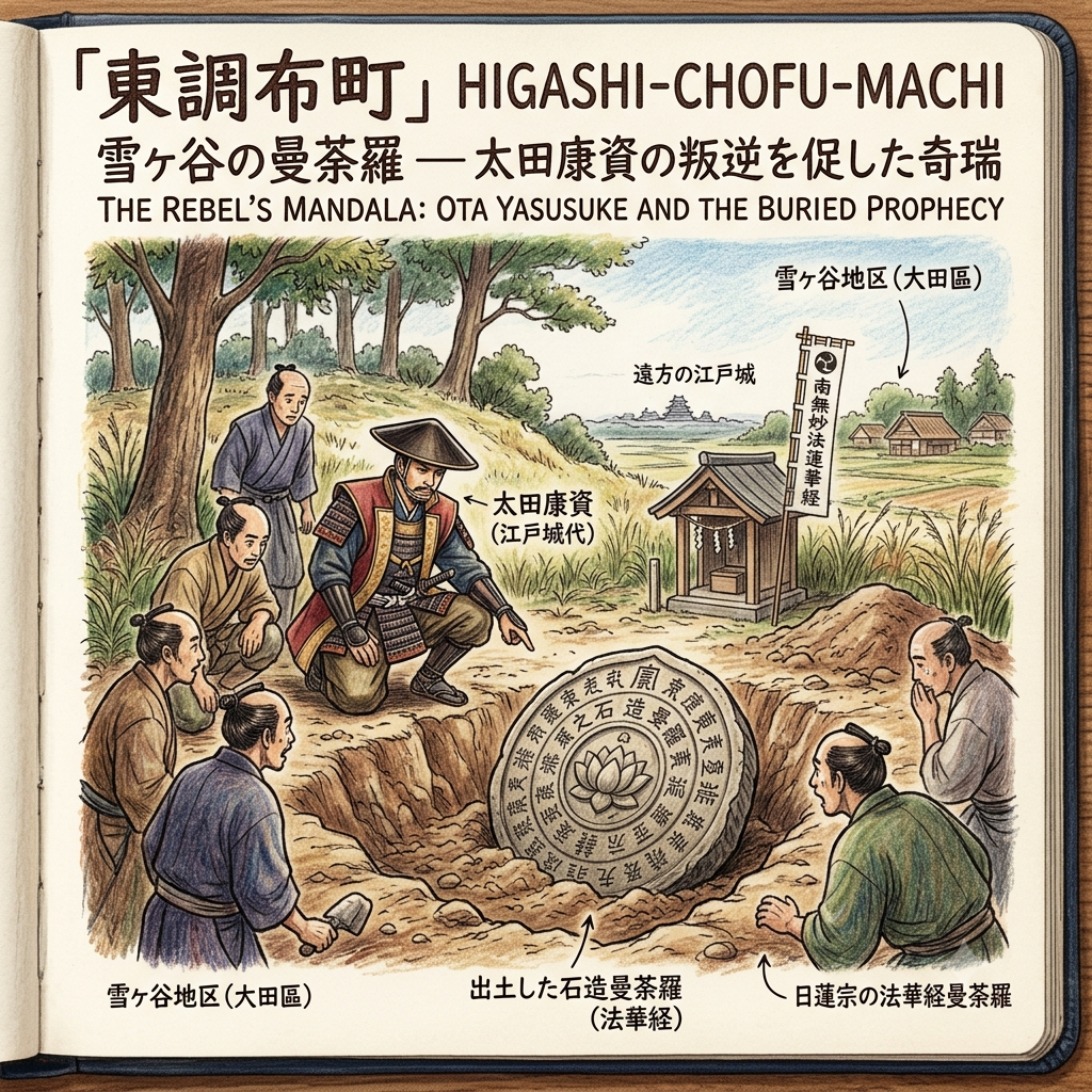
In the 16th century, the Yukigaya region became the stage for a unique fusion of politics and "Hokke-Shinto" syncretism. Ota Yasusuke, the Edo Castle Representative (江戶城代) and a descendant of the builder of Edo Castle, Ota Dokan, was a devout follower of the Nichiren sect. While surveying a high-standing mound in his lands at Yukigaya, Yasusuke reportedly unearthed an ancient stone mandala inscribed with the Lotus Sutra.
The Buried Stele That Sparked A War
Analysis: This discovery was interpreted through the lens of Mitate (mimetic cosmology). Given his status as a high-ranking official of the Hojo regime, Yasusuke viewed the unearthing of the mandala as a "heavenly mandate" to defect. It suggested that the land itself supported his spiritual and political independence. This belief provided the spiritual legitimacy for his rebellion, leading him to align with the Uesugi and Satomi clans against the Hojo.
"The manifestation of the true law from the earth itself is the sign that the divine protects those who uphold the Lotus," Yasusuke’s family history suggests, framing his political rebellion as a supernatural necessity.
4. The Micro-Mountain: One Man’s Quest to Relocate Mount Ontake
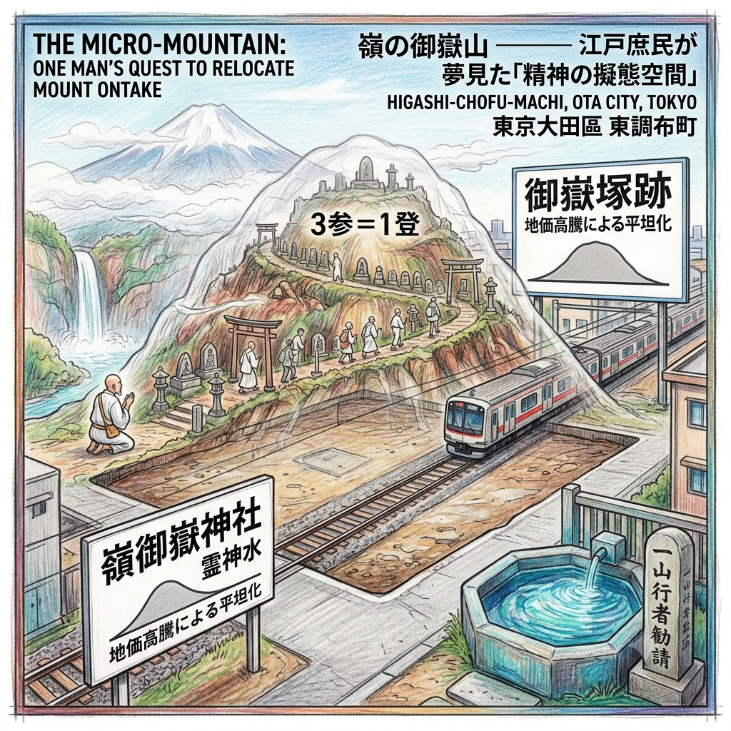
As Tokyo expanded in the 19th century, the ascetic Ichiyama Gyōja (Ichiyama the Practitioner) brought a new layer of spatial genius to Mine village. In 1830, following a divine revelation during his grueling waterfall training on the slopes of Mount Ontake, he established the Mine Ontake Shrine.
Tokyo's Lost Virtual Mountain
The "So What?" Layer: Ichiyama Gyōja understood that not everyone could endure the dangerous trek to the actual 3,000-meter peak. He created a "geometric proxy"—a 4-meter artificial mound called an Ontake-zuka. By precisely projecting the sacred geometry of the distant mountain onto this local mound, he allowed city-dwellers to perform a spiritual "climb." To ascend the miniature path was to undergo a high-dimensional pilgrimage without leaving the plateau.
Critical Reflection: Today, the 4-meter mound is gone, a casualty of the expansion of the Tokyu Ikegami Line and the rising land prices of the 20th century. This "void" in the landscape reveals the friction between sacred geometry and capitalist infrastructure. While the shrine’s "Spirit Water" well remains, the physical "mountain" has been flattened by the relentless march of urban development.
5. The Glass Utopia: A Lost Archipelago of Carnations and Melons
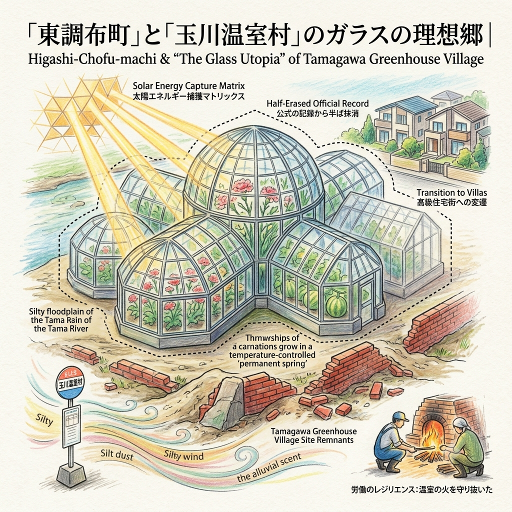
Down on the Tama River floodplains, the 1930s saw the final historical layer: the "Tamagawa Greenhouse Village." Once a site of treacherous marshes, the area was restructured into an engineering marvel of steel and glass. Over thirty horticulturalists utilized the fertile alluvial soil to build a "permanent spring."
Analysis: This was a "thermodynamic restructuring" of the river’s energy, a "Solar Energy Capture Matrix" that turned a site of chaotic flooding into a high-value micro-ecosystem. Instead of retreating from the floodplain, residents used glass to capture solar energy, creating a temperature-controlled environment for carnations and melons.
Tokyo's Lost Glass Utopia
Sensory Detail: Today, standing at the "Tamagawa Onshitsumura" bus stop, the greenhouses have vanished, replaced by modern villas. However, if you look closely at the base of the older walls, you can still see fragments of red brick—remnants of the drainage systems that once supported the glass sea. The river wind here is silty and alluvial, carrying the scent of sand and silt—a ghostly echo of the fields that once bloomed in the river mud.
Conclusion: The Spiritual Energy Buffer of Tokyo’s Edge
The story of Higashi-Chofu-machi is not merely a chronicle of an upscale residential neighborhood. It is the history of a "spiritual energy buffer" (灵性消能矩阵). From the Kofun mounds of the 4th century to the radial "Garden City" planning of the 20th, this landscape has consistently sought to transform external trauma—be it the chaos of a flooding river, the collapse of a samurai dynasty, or the pressures of urbanization—into an orderly, sacred geometry.
The radial planning of modern Den-en-chofu is a high-dimensional restoration of the ancient kekkai (boundaries) established by the Kofun and Hachiman shrines. This land has always been layered with spiritual protections that absorb the shocks of history. Whether through military feng shui or the mimetic cosmology of an artificial mountain, the residents of this plateau have refused to be passive observers of their environment, creating a palimpsest that converts transition into spatial continuity.
As we walk these streets today, we must ask ourselves: how do these unseen layers of geometry influence our own sense of peace? The "unseen" is often more structural than the "seen," and in the quiet groves of Den-en-chofu, the ancient sentinels are still on watch.
To receive more deep-map explorations of Japan’s hidden histories and spatial enigmas, please consider subscribing to our narrative updates.
Traveler’s Appendix: Walking the Layers
How to Walk the History
- Access:
- Tokyu Ikegami Line: Best for accessing Mine Ontake Shrine (Ontakesan Station) and Yukigaya Hachiman.
- Tokyu Tamagawa Line & Toyoko Line: Use Tamagawa Station for accessing the Kofun clusters and the old Greenhouse Village site.
- Recommended Tour Route:
- Start: Tamagawadai Kofun Park. View the Hōraizan Kofun and the Fuji alignment at the Asama Shrine.
- Midday: Walk the Hake cliff line to Den-en-chofu Hachiman Shrine to see the 1802 stone steps and the Nishioka No. 22 mound.
- Afternoon: Take the Ikegami line to Mine Ontake Shrine. Seek out the 400-year-old "Couple Pines" (夫婦松) and the "Spirit Water" well.
- Finish: Walk to the Tama River bank near the "Tamagawa Onshitsumura" bus stop to find red brick remnants of the Greenhouse Village drainage.
- Accommodation Tip:
- Stay in the Ota-ku area to experience the "Hake" cliff line at dawn, when the mist rising from the Tama River recreates the liminal feeling of the ancient boundary.
💡 Frequently Asked Questions about Higashi-Chofu, Tokyo
Q1: Where is Higashi-Chofu in Tokyo, and is it worth visiting?
A: Higashi-Chofu is a historic district name covering present-day Yukigaya, Kugahara, and Den-en-chofu in Tokyo's Ota Ward. Instead of overcrowded tourist traps or commercial malls, this area offers an authentic slice of local Tokyo life, retro Showa-era architecture, and quiet suburban history. Key highlights include Senzokuike Park, vintage shopping streets, traditional public baths (sento like Myojin-yu), and hidden historical remnants. It is ideal for off-the-beaten-path travelers, urban wanderers, and history enthusiasts looking for a peaceful day trip away from central Tokyo crowds.
Q2: How to plan a day trip to Higashi-Chofu and Ota Ward in Tokyo?
A: Take the Tokyu Ikegami or Tokyu Tamagawa Line to begin your itinerary. Start in the morning with a relaxing stroll or paddleboat ride around Senzokuike Park. Head to Yukigaya-Otsuka or Ontakesan Station for lunch along local Shotengai shopping streets serving traditional snacks and ramen. In the afternoon, explore historic shrines and the former site of the pre-war aquarium in Higashi-Chofu Park. Finish your day in the late afternoon with an authentic bathhouse experience at a classic wooden sento like Myojin-yu before dining at a cozy neighborhood izakaya.
Q3: What hidden history and secret spots are in Higashi-Chofu (Yukigaya / Ontakesan)?
A: Higashi-Chofu preserves fascinating stories of Tokyo’s early suburban development. Before WWII, it transitioned from farmland into an experimental garden city. It once housed the famous Taisho-era Higashi-Chofu Aquarium, whose subtle ruins can still be spotted inside Higashi-Chofu Park today. The neighborhood was also frequented by historical figures like Katsu Kaishu during the Bakumatsu period. Exploring these quiet streets reveals traditional palace-style (Miyazukuri) bathhouse architecture, old wooden storefronts, and forgotten landmarks that showcase Tokyo’s transformation over the past century.
Reference and Further reading
- 日本有数の高級住宅街に残る旧町名「東京市大森區田園調布」 - 歩・探・見・感,
- 東調布町 - Wikipedia,
- 鵜の木(ウノキ)はどこ? わかりやすく解説 Weblio辞書,
- 大田区「西岡第22号古墳 (田園調布古墳群) 」,
- 田園調布八幡神社 | 東京都大田区 | 古今御朱印研究所,
- 多摩川両岸の地形や土地利用からの考察 高津区・中原区と世田谷区を中心に - 川崎市,
- 嶺御嶽神社 / 東京都大田区,
- 雪ヶ谷八幡神社,
- 玉川温室村 - 株式会社大田花き花の生活研究所,
- 多摩川台のあじさいと等々力渓谷 2023.6.7(水) - マダオなWALKING′!,
- 宝萊山古墳(ほうらいざんこふん) - 六部塾・小金井風土知,
- 大田区「西岡53号墳」 | 古墳なう - FC2,
- 西守稲荷神社 / 東京都大田区 - 御朱印・神社メモ,
- 大田区の古い町並み,
- 山岳信仰で知られる御嶽神社 おんたけ神社 オオカミ狛犬 - 大田区の歴史と不思議な江戸時代 目次,
- 御嶽神社 (大田区北嶺町),
- 田園調布を抱え込む大田区境|歩いて、探して - note,
- 大田区 田園調布(でんえんちょうふ) - 住建ハウジング,
- 田園調布の開発 - 三井住友トラスト不動産,
- 荏原郡 - Wikipedia,
- 解説ページ - JLogos,
- 大田区「西岡第47号古墳・修道院構内古墳 (田園調布古墳群) 」,
- 田園調布八幡神社 / 東京都大田区,
- 地方民は意外と区別がつかない? 田園調布と調布は何がどう違うのか | at home VOX(アットホームボックス),
- 大森区 - Wikipedia,
- 雪ヶ谷八幡神社 / 東京都大田区 - 御朱印・神社メモ,
- 嶺 御嶽神社 | 東京都大田区 | 古今御朱印研究所,
- 大田区「西岡第33号古墳 (田園調布古墳群) 」 | 古墳なう - FC2,
- 富士見坂 扇塚古墳(跡) 多摩川浅間神社(浅間神社古墳) 東京都大田区田園調布1丁目,
- 第4回 初代館長、西岡秀雄 学芸員コラム - 大田区,
- 第5回 初代館長、西岡秀雄 学芸員コラム - 大田区,
- 西岡第51号墳 - 全国文化財総覧,
- 第8回 初代館長、西岡秀雄 学芸員コラム - 大田区,
- 品川道(3)筏道03-野毛 - TEIONE BLOG - 平山 貞一,
- 品川道(3)筏道04-田園調布本町 - TEIONE BLOG - 平山 貞一 - エキサイトブログ,
- 雪ヶ谷八幡神社【東京都大田区】|もんシュラ - note,
- 雪ヶ谷八幡神社 - 散歩日記,
- 由緒 - 大田区御嶽神社,
- おおた区報WEB版 令和元年9月21日号〔トップページ・特集〕 - 大田区,
- 御嶽神社 - 東京都神社庁,
- 大田区「御嶽神社」の見どころはどこ?概要やお祭りの内容も含めてご紹介,
- 学芸員イチオシの一品!」第4弾のご案内 - 大田区,
- 3:都市郊外としての発展 ~ 自由が丘・田園調布 | このまちアーカイブス - 三井住友トラスト不動産,
- 玉川温室村があって今日の花産業がある | 宇田 明の『もう少しだけ言います』,
- 前田有紀の一“花”言vol.72「カーネーション」〜母の日に贈りたい花 - LoveGreen,
- 田園調布八幡神社
 Lawrence
 Lawrence
 Lawrence
Historical Travel Stories publishes long-form historical travel writing rooted in primary research. All historical claims in this article are sourced from institutional records, academic publications, and municipal historical archives. Last updated: July 2026.