(ENG) Komazawa, Tokyo: What the Park, the University, and the Street Names Are Still Telling You
A historical travel guide to Komazawa, Tokyo. Explore Komazawa Olympic Park through five surprising stories—from Shogun hunting grounds and Meiji racetracks to wartime history—and discover the hidden layers of time beneath this modern green oasis.

This is a historical travel story and walking guide to Komazawa, a vibrant district in Setagaya, Tokyo. Through five fascinating histories, it explores the iconic Komazawa Olympic Park and its surroundings, revealing how a Shogun hunting ground, a Meiji-era racetrack, and wartime remnants transformed into a modern urban oasis. Readers will follow a thoughtful walking route to discover the hidden layers of time and changing perspectives beneath Tokyo’s everyday greenery.

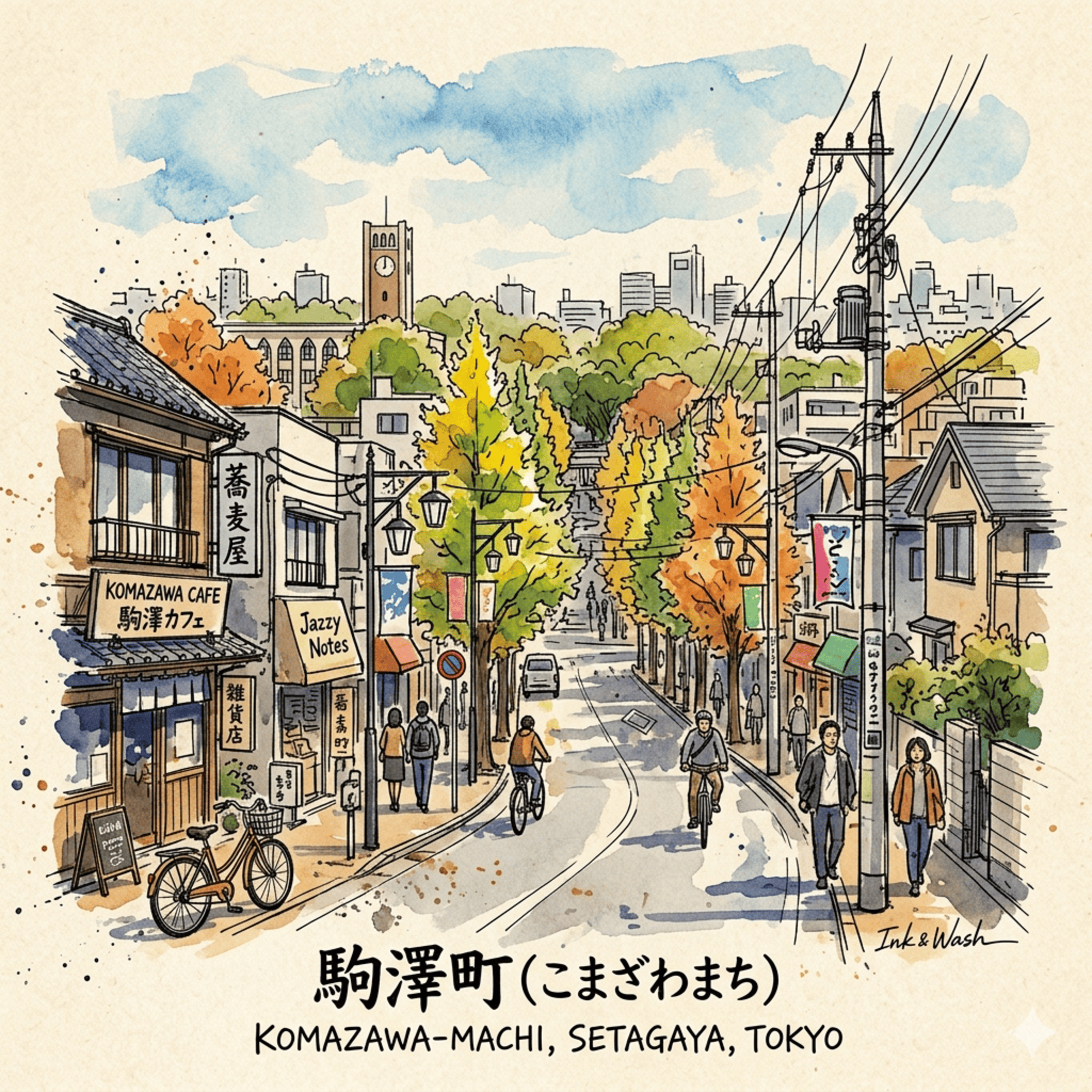
Most visitors to this quiet corner of southwest Tokyo come for a jog. The park is well-designed, the trees are generous, and the Olympic memorial tower stands at a modest height against the sky — easy to photograph, easier to walk past. Nothing about the scene announces itself as extraordinary.
But Komazawa (駒沢) is one of the most densely layered places in Tokyo's modern history. Within a few square kilometers, you can trace a medieval horse-pasture culture, a Buddhist institution that survived government suppression, a phantom Olympics that Japan surrendered before a single brick was laid, an Art Deco water tower built to quench a city that didn't yet exist, and a place name that was bureaucratically erased — then quietly brought back to life thirty-five years later.
These are not the things the tourist boards talk about. They are exactly the kind of histories that make a neighborhood worth understanding.
Listen to the historical stories told in detail (For subscribers only)
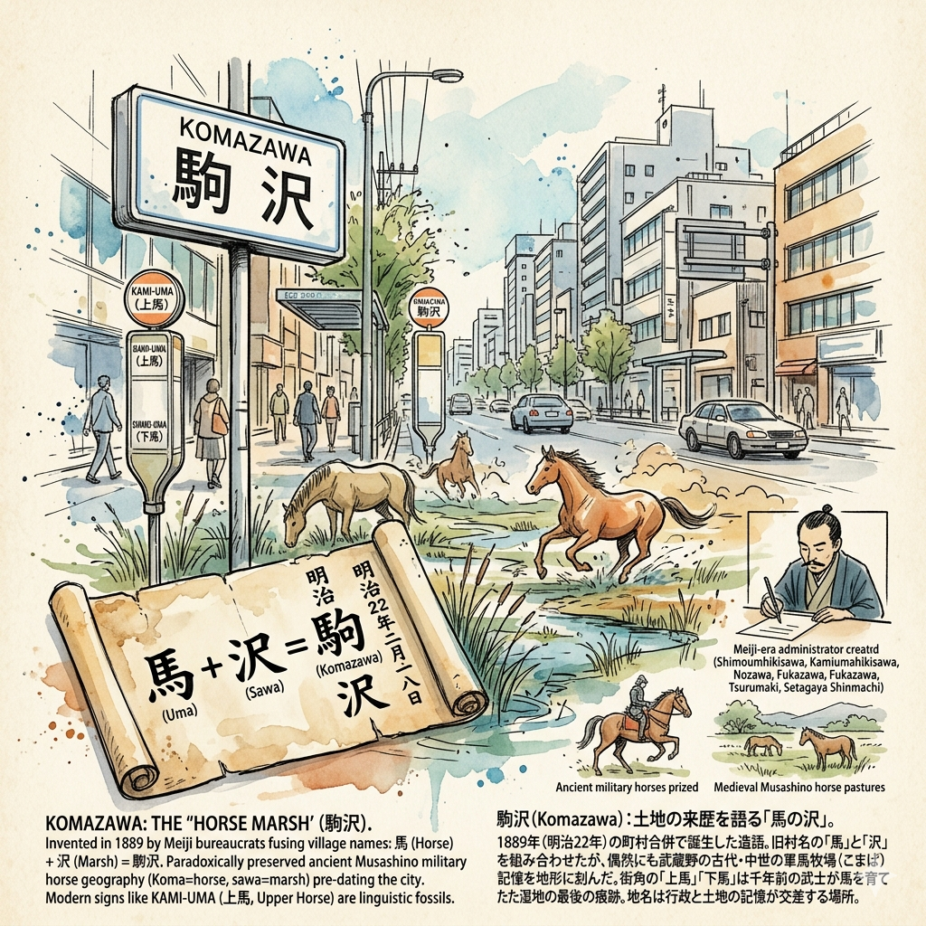
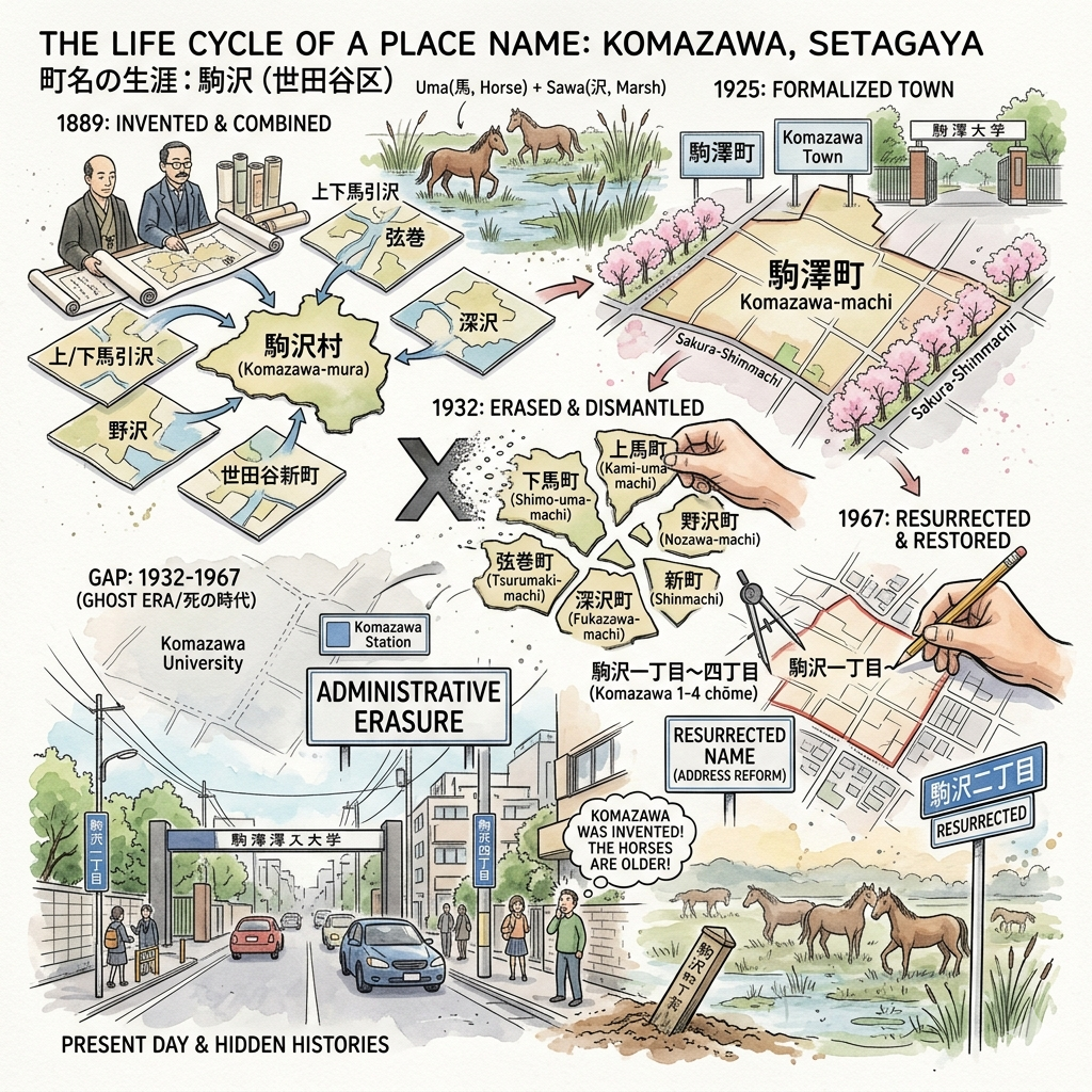
The Name You're Standing In Was Invented in 1889
The first thing to know about Komazawa is that it doesn't entirely exist — or rather, it was conjured into existence by a Meiji-era administrator with a pen and a political problem to solve.
In 1889, Japan's new Municipal Government Act forced the merger of dozens of small rural villages on Tokyo's southwestern fringe. Six of them — Shimoumahikisawa, Kamiumahikisawa, Nozawa, Fukazawa, Tsurumaki, and Setagaya Shinmachi — were consolidated into a single administrative unit. They needed a shared name.
The solution was synthetic. Officials took the character for "horse" (uma, 馬) from the village names "Upper and Lower Umahikisawa," elevated it to its more classical form (koma, 駒), then appended the character for "marsh" (sawa, 沢) borrowed from both Nozawa and Fukazawa. The result — Komazawa — was a bureaucratic portmanteau that sounded ancient but was freshly coined.
What the name accidentally preserved, however, is genuinely old. Across the western reaches of the Musashino Plateau — the great upland that Tokyo now sits upon — an entire cluster of place names begins with koma: Komazawa, Komaba, Komagome. Local historical records from Meguro Ward are explicit about what this cluster means:
"Komaba is one of the old place names across the Musashino area that refers to horses. Koma means horse, and ba means paddock or pasture. The fine horses produced here were prized as warhorses through ancient and medieval times."
Komazawa, in other words, was probably a marshy horse-pasture — a komazawa, a "horse marsh" — long before any Meiji bureaucrat gave it a formal certificate. The name preserved a memory of medieval military geography that the administrators themselves likely didn't realize they were encoding.
Walk through the neighborhood today, and you'll still find the echoes. The adjacent addresses of Kami-uma (上馬, "Upper Horse") and Shimo-uma (下馬, "Lower Horse") survive as street names in the present ward. Nobody explains them. They sit on signposts like linguistic fossils, the remnant vocabulary of a landscape that vanished before living memory.
What this reveals: Tokyo's urban fabric is threaded with place names that predate the city itself by centuries. The Musashino Plateau was a horse-and-farmland frontier long before it became a residential district, and the name clusters of its western wards are among the few surviving traces of that medieval geography. Komazawa is a case study in how administrative acts — even thoughtless or expedient ones — can accidentally archive history.
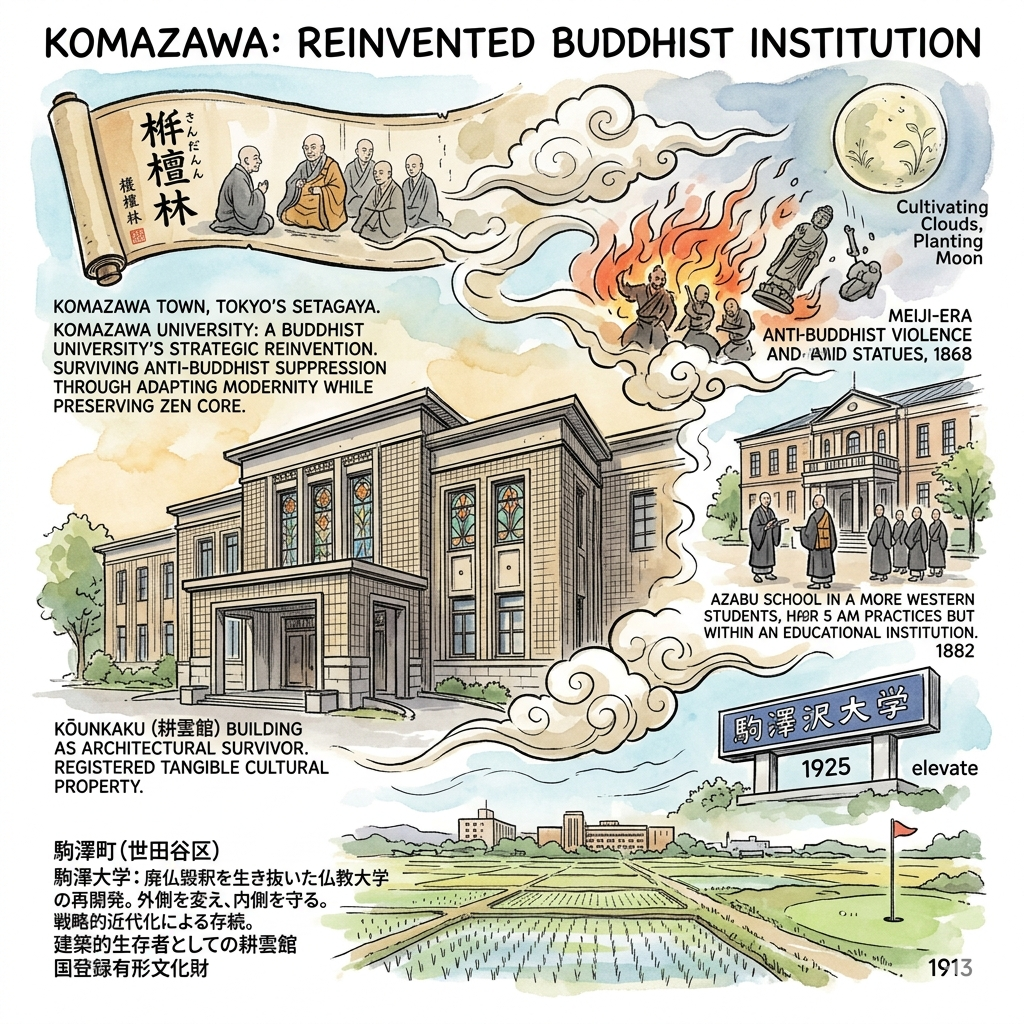
A Buddhist University That Survived by Reinventing Itself
In 1913, a Buddhist institution arrived in the fields of Komazawa and set down roots that have never moved. To understand why that arrival matters, you need to begin three centuries earlier — and with a catastrophe.
The institution now known as Komazawa University traces its founding to 1592, when the Sōtō school of Zen Buddhism established a small seminary at the Kichijoji temple in Edo's Surugadai district. It was named the Kichijoji-eka Gakuryō — a study hall for monks. After the great Meireki fire of 1657 displaced it, the seminary relocated, and a visiting Chinese Buddhist master renamed it the Sendanrin (栴檀林) — the "Sandalwood Forest," invoking the Sanskrit image of the rarest and most fragrant of trees as a metaphor for wisdom nurtured in seclusion.
For over two hundred years, the Sendanrin functioned as the intellectual core of Sōtō Zen in Japan. Then the Meiji government arrived.
How the Meiji State Tried to Erase Buddhism
The government's 1868 Shinto-Buddhism Separation Edict triggered a wave of anti-Buddhist violence across Japan — temples burned, monks forcibly defrocked, Buddhist statues smashed. The ideological driving force was State Shinto: the new government needed a national religion to anchor imperial authority, and Buddhism, with its continental origins and its historical entanglement with the old feudal order, was an obstacle.
The Sōtō school's response was remarkable in its strategic intelligence. Rather than resist in ways that invited destruction, the institution chose to modernize on the government's own terms — adopting Western-style academic structures while quietly preserving its monastic core. By 1882, it had opened the Sōtō Sect University School (Sōtōshū Daigakurin) in Azabu, Tokyo, operating out of a building in what is now the Roppongi district of Minato Ward. Students rose at 5 a.m. for communal sutras in the great hall, ate communally, and followed the daily rhythms of a training monastery — but they were enrolled in a recognized educational institution, filing curricula with the Meiji government's Ministry of Education.
The Move to Komazawa (1913)
When the institution relocated to the agricultural village of Komazawa in 1913, it was moving to what was still, essentially, open farmland. The land was cheaper. The air was quieter. The distance from the city made it easier to maintain the contemplative atmosphere that Sōtō doctrine demanded. And in 1925, when the school was formally elevated to university status under the new University Ordinance, it took the name of its new home: Komazawa University (Komazawa Daigaku).
The naming was not incidental. A Buddhist institution, which had survived suppression by adopting the forms of secular modernity, now anchored itself to a piece of Musashino farmland and gave the land its institutional identity. The agricultural place name became the academic brand — and eventually, through the university's famous athletic teams and its ubiquitous appearance on Tokyo marathon relay race banners, the brand would eclipse the agricultural memory almost entirely.
The Kōunkaku and the Architecture of Survival
In 1928, the university completed a library and research building that stands as one of the most quietly remarkable structures in southwest Tokyo: the Kōunkaku (耕雲館), now serving as the Zen Cultural History Museum.
Its architect, Sugahara Eizō, was deeply influenced by Frank Lloyd Wright — specifically the Wright "earthquake-proof" aesthetic that had demonstrated its worth when the Imperial Hotel survived the 1923 Great Kantō Earthquake. The Kōunkaku's exterior is clad in scratch-tile (スクラッチタイル) in the same design tradition as the Imperial Hotel. Its stained-glass windows fracture the light in patterns that feel simultaneously Buddhist and Art Nouveau. The name means, roughly, "the hall where one cultivates clouds and plants the moon" — a classical Zen metaphor for the kind of effortful, directionless cultivation that is the heart of contemplative practice.
In March 2025, the Japanese government announced the building's registration as a National Registered Tangible Cultural Property — the formal recognition that what survived the Meiji suppression, the earthquake, the war, and seven decades of campus construction is worth protecting.
The building stands quietly at the edge of the campus, its scratch-tile facade darkened by a century of Tokyo weather. Most students walk past it on the way to the cafeteria without a second glance. That, too, is a kind of history.
What this reveals: The story of Komazawa University is a study in institutional survival under ideological pressure. The Sōtō school didn't preserve itself by refusing to modernize — it preserved itself by modernizing strategically, keeping its contemplative core intact while presenting a secular face to an increasingly hostile state. This is a pattern visible across Japanese religious history in the Meiji period, but Komazawa makes it unusually legible, because the architecture, the curriculum structure, and the founding documents still exist.
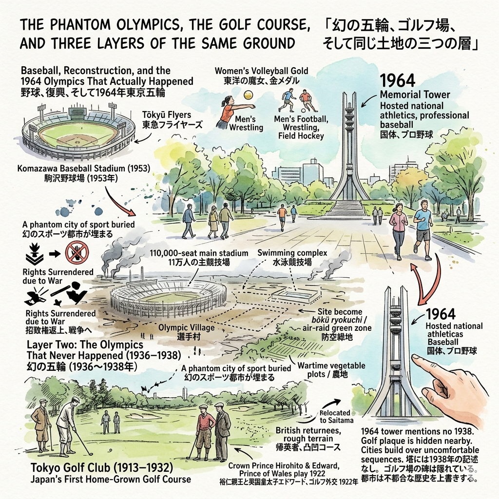
The Phantom Olympics, the Golf Course, and Three Layers of the Same Ground
There are very few places in Tokyo where you can stand on soil that has been, in sequence, a fairway, a military training ground, a wartime vegetable plot, a baseball stadium, and an Olympic venue. Komazawa Olympic Park is one of them.
Layer One: Japan's First Home-Grown Golf Course (1913–1932)
In 1913 — the same year the Buddhist university arrived — a group of Meiji-era elites broke ground on what would become the Tokyo Golf Club (東京ゴルフ倶楽部), the first golf course in the Kantō region built and managed entirely by Japanese members. (The only previous course was reserved for foreign residents.)
The club opened with six holes in 1914. Its members were largely returnees from Britain who had absorbed the sport there; early accounts suggest that some of them were privately appalled by the quality of the course but kept their views to themselves, while members who had never seen a proper links course assumed the rough terrain was simply how golf was supposed to look.
The club's most diplomatically significant moment came on April 19, 1922, when the Crown Prince Hirohito (the future Shōwa Emperor, then serving as regent) played a friendly round with Edward, Prince of Wales. The Anglo-Japanese Alliance had already formally ended the previous year, and the relationship between the two empires was fraying. A round of golf on a muddy plot in the western suburbs of Tokyo was one of the last acts of personal diplomacy between the two royal houses before the relationship collapsed entirely. Both men would go on to become the most controversially positioned monarchs in their respective countries' twentieth-century histories.
By 1932, rising land prices pushed the club north to Saitama Prefecture. The Komazawa course was vacated and subsequently taken over by the Tokyo metropolitan government.
Layer Two: The Olympics That Never Happened (1936–1938)
In 1936, Tokyo was awarded the 1940 Summer Olympics — the Games planned to coincide with Japan's celebration of the 2,600th anniversary of the legendary Emperor Jimmu's founding of the imperial line. The original main venue was to be expanded near Meiji Jingū Gaien. When that plan proved logistically unworkable, attention shifted in April 1938 to the vacant Komazawa golf land: 13 man-tsubo (approximately 43 hectares) of open ground on which planners envisioned a 110,000-seat main stadium, a swimming complex, an Olympic Village, and a commemorative plaza called the "Imperial Era 2,600th Anniversary Square."
Four months later, in July 1938, Japan surrendered the hosting rights. The Second Sino-Japanese War — already a year old — had made the international climate untenable, and domestic resources were being redirected toward the military. The Komazawa stadium was never built. Not a single shovel of ceremonial earth was turned.
The site was subsequently converted to military uses, and during the later years of the war it was designated a bōkū ryokuchi (防空緑地) — an "air-raid green zone," an open space maintained to act as a firebreak in the event of bombing — and then parceled into agricultural plots to address food shortages.
A phantom city of sport was buried in the soil before it was ever raised from it.
Layer Three: Baseball, Reconstruction, and the 1964 Olympics That Actually Happened
By 1949, the site had been cleared and reconfigured as the Komazawa General Athletic Ground, hosting the 4th National Athletic Meet. In 1953, Tōkyū Corporation built the Komazawa Baseball Stadium on the grounds, which became the home field of the Tōkyū Flyers — the professional baseball team that would eventually, through a long chain of name changes and ownership transfers, become the Hokkaido Nippon-Ham Fighters.
When Tokyo was awarded the 1964 Olympics, Komazawa was redesignated as the second-largest venue complex. It hosted men's football, women's volleyball (where the Japanese team won gold in a match that became one of the defining cultural events of postwar Japanese society), wrestling, and field hockey. The baseball stadium was demolished to make room.
The 50-meter Olympic Memorial Tower, built in 1964, still stands at the park's center. Its upper floors contain a water tank. It is the only original 1964 infrastructure still standing on the site — and almost nobody who walks past it knows that the ground beneath their feet was once designated to hold eleven times as many spectators for an Olympics that history cancelled.
What this reveals: The three-layer history of Komazawa's park is a compressed record of Japan's twentieth-century political biography — imperial ambition, military overreach, catastrophic defeat, postwar reconstruction, and cautious international reintegration. Each layer erased the one before it, almost completely. The memorial tower from 1964 contains no reference to 1938. The plaque for the golf course is hidden in a small community park nearby, visible to almost no one. This is how cities manage uncomfortable sequences: by building over them, one decade at a time.
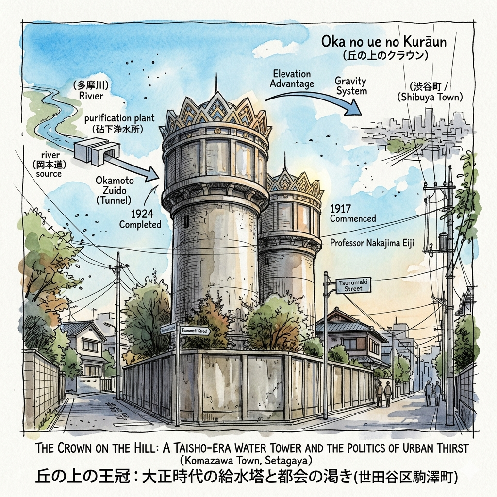
The Crown on the Hill: A Taisho-Era Water Tower and the Politics of Urban Thirst
A short walk northeast of Sakura-Shimmachi Station, tucked behind a high concrete fence in a residential street, stand two cylindrical water towers from 1924. They are roughly 30 meters tall. Their tops are decorated with geometric crown-shaped ornaments in the tradition of Taisho-era historicist architecture. Locals call them the Crown on the Hill (Oka no ue no Kurāun, 丘の上のクラウン).
Most visitors to the Komazawa neighborhood walk past them entirely. This is a mistake.
The Urban Thirst That Created Them
In 1917, the administration of Shibuya Town (Shibuya-machi, the precinct that would become today's Shibuya Ward) commissioned Professor Nakajima Eiji of Tokyo Imperial University — widely credited as the father of modern Japanese water infrastructure — to design a municipal water supply system. The problem was urgent: Shibuya's population was growing faster than its well supply could sustain, and the water quality was deteriorating badly.
Nakajima's solution was ingenious and, for its time, unprecedented in Japan. Rather than dig a direct pipeline through increasingly expensive and densely built urban land, he designed a gravity-fed chain:
Step one: Draw groundwater from the Tama River floodplain at a purification facility in Kinuta (then a rural village, now part of Setagaya Ward). Step two: Pump the purified water underground through a dedicated tunnel built beneath the Okamoto Hachiman Shrine grounds — a tunnel called the Okamoto Zuido (岡本隧道). Step three: Force the water upward by pump into the twin storage towers at Komazawa. Step four: Allow gravity to carry the water naturally downhill to Shibuya, without further pumping.
The elegance was in the geography: Komazawa sat at exactly the right elevation to make the gravity system work. A rural agricultural village became the critical infrastructure node for the urban expansion of its neighbor.
Construction began in May 1921. The Great Kantō Earthquake struck in September 1923, disrupting but not halting the project. The system was completed in March 1924.
The pump house (haisuipumujo, 配水ポンプ所) was added in 1933. Both the towers and the pump house were formally recognized as Civil Engineering Heritage sites by the Japan Society of Civil Engineers in 2012.
What the Towers Mean Beyond Engineering
The Komazawa water towers are rarely included in accounts of Taisho-era architecture, which tends to focus on grander civic buildings — the Marunouchi office blocks, the Hibiya concert hall, the rebuilt Imperial Hotel. But the towers deserve attention precisely because of their ordinariness.
They were built to serve one ward while physically standing in another — an arrangement that reveals the administrative fragmentation of Taisho Tokyo's suburban fringe, where multiple small municipalities were scrambling to build infrastructure faster than their boundaries could be rationalized. The water didn't belong to the land it was stored on. The land didn't benefit directly from the infrastructure built upon it. This is the logic of colonial geography applied within a single metropolitan area: resources extracted from one place to serve another.
The crown ornament on the tower tops — historically eclecticist, vaguely Byzantine, unmistakably decorative — suggests that someone in 1924 thought it worth designing a water storage facility that could also be looked at with pleasure. The instinct was correct. A century later, the towers are among the most visually distinctive objects in the entire ward.
The facility is not open to the public due to security restrictions. But both towers are visible from the perimeter fence on Tsurumaki Street, and on several evenings each year, the crown ornaments are illuminated. Local residents almost never mention this. The Tokyo metropolitan water authority mentions it in a footnote.
What this reveals: Infrastructure history is rarely romantic, but the Komazawa water towers are a reminder that the act of bringing clean water to a growing city is one of the most consequential things a government can do — and that the decisions about where to locate that infrastructure (whose land, whose geology, whose elevation) are always political decisions wearing engineering clothes.
A Place Name That Died and Came Back
The final layer of Komazawa's history is the most abstract and perhaps the most instructive.
In 1932, when Tokyo Metropolitan Government absorbed all of Ebara County — including Komazawa Town, which had only received its formal town designation seven years earlier in 1925 — the name "Komazawa" was administratively erased. The area was divided back into its constituent village-derived neighborhoods: Kami-uma, Shimo-uma, Nozawa, Tsurumaki, Fukazawa, and Shinmachi. The name that had been assembled from pieces in 1889 was disassembled again in 1932. For thirty-five years, "Komazawa" existed only in the university's name, in the memory of residents who had used it, and in the signboards of the train station.
In 1967, as part of a national residential address reform, the neighborhood reclaimed the name. The current "Komazawa 1–4 chōme" (駒沢一丁目〜四丁目) does not perfectly map onto the earlier town's boundaries, and the newer designation covers only a portion of what the old Komazawa Town once encompassed. But the name returned.
This cycle — invented, dismantled, resurrected — is not unique to Komazawa. It is the standard rhythm of Japanese urban administrative history. What makes Komazawa unusual is how completely the name's artificial origins have been forgotten, even by its own residents. Most people who live in the neighborhood today would be surprised to learn that "Komazawa" was coined by a committee in 1889, cancelled by a different committee in 1932, and restored by yet another committee in 1967. They would be even more surprised to learn that the part of the name referring to horses is probably the oldest truth about the place — older than any of the administrative decisions that have shaped it since.
What this reveals: Place names carry history that their residents no longer consciously hold. The administrative violence done to Japanese place names through the Meiji, Taishō, and Shōwa periods — through forced mergers, wartime consolidations, postwar reorganizations — is a history mostly invisible to anyone walking through a neighborhood today. Komazawa's name is a small, legible example of a much larger phenomenon: the way that political change writes and rewrites the landscape, one street sign at a time.
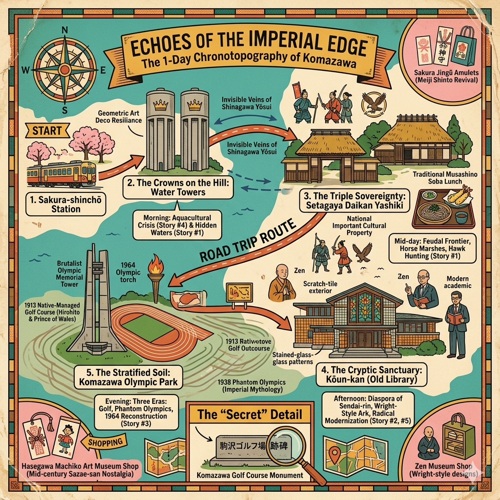
Walking Komazawa: What to Look For and Where to Go
History is most useful when it is spatial. Here is how to move through the Komazawa neighborhood with its layers in mind.
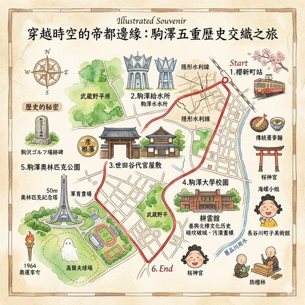
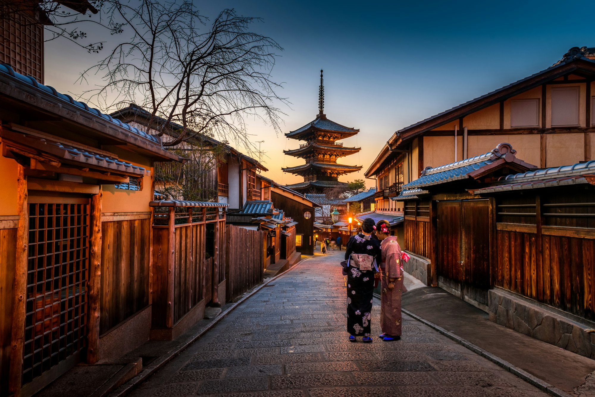
Start at Komazawa-daigaku Station (東急田園都市線・駒沢大学駅). The station name itself is the first document: a Buddhist institution's 1925 renaming of itself after its new agricultural address, now the primary identifier for the entire district.
Walk northwest along Komazawa-dori toward the university campus. The Kōunkaku/Zen Cultural History Museum is on the left side of the campus, identifiable by its scratch-tile facade and narrow windows. Open to the public, free of charge, and almost entirely overlooked by non-specialist visitors. The permanent collection includes documents from the 1882 founding of the Sōtō Sect University School and artifacts from the seminary's communal life. Give it at least forty-five minutes.
Continue west and north toward Komazawa Olympic Park. The entrance near the intersection of Komazawa-dori and Kanpachi-dori puts you in front of the Olympic Memorial Tower. Read the plaque slowly: it mentions 1964 extensively. It does not mention 1938. That silence is part of the story.
Walk the park perimeter toward the Komazawa 1-chōme West Park (駒沢1丁目西公園). Near the western edge, partially obscured by street trees, stands a small granite marker: "Komazawa Golf Course Site" (駒沢ゴルフ場跡). This is all that remains of Japan's first domestically managed golf course, the fairways where a future emperor and a future abdicated king played their diplomatically freighted round in 1922.
From the park, take the short walk northeast toward Sakura-Shimmachi. On the street leading toward the station, the perimeter fence of the Komazawa Water Supply Station (駒沢給水所) becomes visible. The two crown-topped towers rise above it. The facility is closed to visitors, but the towers themselves are clearly visible from the street. On certain evenings, you'll see them lit. If you do, the Taisho era becomes briefly legible in the darkness above a residential block.
Hidden Gem: Setagaya Daikan-Yashiki (世田谷代官屋敷)
A twenty-minute walk or short bus ride from Komazawa-daigaku Station, the Setagaya Magistrate's Residence (世田谷代官屋敷) is one of Tokyo's most overlooked historical sites. The main hall dates to 1737 — the private residence and official office of the Ōba family, who served as magistrates for the Hikone Domain's Setagaya territory through the entire Edo period. The building is a National Important Cultural Property and includes a preserved "white sand court" (shirasazu) where formal judgments were handed down. The adjacent Setagaya Ward Local History Museum holds documents that illuminate the feudal administrative structure that governed the villages that would eventually become Komazawa. Almost no tourists come here. Entry is free.
A Final Thought: What a Neighborhood Knows About Itself
There is a version of Komazawa that most of its residents know: a quiet residential neighborhood with a good university, a popular park, and a convenient train line. That version is accurate and completely insufficient.
The deeper version — the one visible only to those who slow down enough to read the street signs, look up at the water towers, walk the full perimeter of the park, and sit quietly in the Kōunkaku — is a neighborhood that contains, in concentrated form, much of what happened to Japan in the twentieth century.
A medieval horse-pasture became a feudal domain village. The village was merged and renamed. The renamed village was claimed by a persecuted religious institution. The institution outlasted the persecution and gave its name to a university. The fields surrounding the university were redesignated as a phantom Olympic venue, then a military training zone, then a vegetable plot, then a baseball stadium, then an actual Olympic venue. A water tower was built to quench a city that was still, at the time of its construction, mostly farmland. A place name was invented, abolished, and quietly restored.
What connects these five stories is not a single theme but a single question that each of them raises in a different register: who decides what a place is for?
The answer, across all five histories, is always the same: someone with authority who may not have long-term consequences in mind, acting in response to immediate pressures, and leaving behind a landscape that the next generation inherits without explanation.
The water towers are still there. The crown ornaments are still lit, on certain evenings. The golf course memorial marker is still readable, if you know where to look. The Buddhist university is still teaching, in the tradition of a founder who believed that practice and study are inseparable.
All of this is history that can be walked. The harder part is learning to see it.
If you found Komazawa's layers interesting, explore our wider guide to [Tokyo's forgotten neighborhoods and the history beneath them], or go deeper with [Setagaya Ward: a walking guide to Tokyo's lost villages]. For the 1964 Olympics and its urban legacy, see [The 1964 Olympics and what Tokyo's urban landscape still remembers].
Subscribe to the Historical Travel Stories newsletter for one deeply researched place delivered to your inbox each month — no itineraries, no packing lists, just history you can walk.
Practical Information
How to Get There
Komazawa-daigaku Station (駒沢大学駅) is on the Tokyu Den-en-toshi Line (東急田園都市線), approximately 12 minutes from Shibuya Station by local train. The station is a 5-minute walk from the university campus and a 10–15 minute walk from Komazawa Olympic Park. No transfers are needed from central Tokyo.
IC card access: All major IC cards (Suica, Pasmo) work on the Tokyu Den-en-toshi Line.
From Narita Airport: Take the Narita Express to Shibuya, then transfer to the Tokyu Den-en-toshi Line (approximately 75–90 minutes total).
From Haneda Airport: Take the Keikyu Line to Shibuya, then transfer (approximately 35–40 minutes total).
Where to Stay
The Komazawa neighborhood is primarily residential. For accommodation, the most practical base is Shibuya (12 minutes by train) or Sangenjaya (two stops from Komazawa-daigaku on the same line, with more budget options and a lively local atmosphere).
Mid-range: Hotel Gracery Shibuya or Shibuya Excel Hotel Tokyu offer easy access and solid value.
Character accommodation: Several traditional machiya guesthouse options operate in the Sangenjaya and Setagaya areas — search for "Setagaya guest house" or "Sangenjaya machiya stay" for locally distinctive alternatives to chain hotels.
Recommended Nearby Experiences
Zen Cultural History Museum (禅文化歴史博物館) — Komazawa University campus. Free admission. Open Tuesday–Saturday. Confirm current hours before visiting.
Setagaya Daikan-Yashiki (世田谷代官屋敷) — 20 minutes by bus from Komazawa-daigaku Station, or a 30-minute walk through Setagaya's residential backstreets. Free admission. Combined visit with the Setagaya Local History Museum is strongly recommended.
Komazawa Olympic Park — Open daily, free admission. The park is large enough that a full circuit, walking slowly with stops at the Memorial Tower, the athletic facilities, and the western park marker for the golf course, takes approximately 90 minutes.
Komazawa Water Supply Station viewing — No admission; viewed from the street along Tsurumaki-dori. Illumination events are occasional and unannounced — follow the Komazawa Water Tower Landscape Heritage Preservation Society (コマQ) for event schedules.
Walking the old Shinagawa Water Channel route — The buried water channel that once crossed Komazawa's southern boundary can be traced through subtle changes in street alignment and elevation in the Tsurumaki and Yoga neighborhoods. No guided tour exists; the best resource is researcher Watanabe Kazuji's published survey, available in Japanese at major Tokyo libraries.
Q & A
How did Zen philosophy influence the development of Komazawa?
Zen philosophy has served as the foundational "cultural DNA" for Komazawa, shaping its identity from a remote rural village into a modern intellectual and spiritual center. This influence is evident through several key historical and developmental axes:
1. Establishing a "Knowledge Enclave" through Cultural Strategy
The defining moment for Komazawa’s modern identity was the 1913 relocation of the Soto Zen Specialized School (now Komazawa University) to the area. This move was a deliberate "cultural strategy" to escape the bustling urban core of Tokyo in favor of a broader, more focused environment. By choosing this location, the institution established a legacy of "tranquility and focus" that elevated Komazawa to the center of modern Japanese Soto Zen education and thought.
2. The Concept of "Engaged Zen Scholarship"
Zen philosophy influenced the development of Komazawa by bridging the gap between spiritual tradition and modern secular needs. Starting in 1925, the university's curriculum was designed to demonstrate "consistency with Zen beliefs" by training not just monks, but also newspaper journalists, magazine editors, and business managers. This approach, known as "Engaged Zen Scholarship," treated Zen education as a method of spiritual discipline to be actively applied by elites within secular society, rather than a retreat from the world.
3. Spatial Zen and Architectural Expression
The architectural heritage of the area also reflects Zen's influence. The university’s old library (Kōunkan), designed by Eizō Sugawara, represents a blending of Japanese and Western styles that maintains a sense of restraint and order. This "spatial Zen" embodies the Taishō-era confidence in modernization while retaining traditional philosophical values of discipline and structural integration.
4. Community Stability and Local Faith
Beyond the academic institution, Zen philosophy influenced the grassroots development of the community through Ryūunji Temple, a Soto Zen temple that has served as a spiritual pillar for centuries. The temple’s "Child-Rearing Jizō Bodhisattva" represents a micro-level application of Zen faith, providing a sense of social stability and local protective power that balanced the grander academic narratives of the university.
5. The "Zen and Sport Dual Track"
Perhaps the most unique influence is how Zen philosophy created a balancing force against the area's modern athletic history. Komazawa’s development is characterized by a "Zen and Sport Dual Track"—a rare urban identity that successfully manages the tension between extreme dynamism (athletic competition in the Olympic Park) and extreme stillness (Zen meditation in the university and temples). This duality allows Komazawa to function as both a modern arena and a place for deep contemplation.
What is the ‘Zen and Sport Dual Track’ identity?
The “Zen and Sport Dual Track” identity describes the unique urban character of Komazawa Town, which has developed as both a profound center for spiritual contemplation and a modern arena for international athleticism. This identity is defined by the coexistence of two seemingly contradictory forces: extreme stillness and extreme dynamism.
According to the sources, this dual identity is built upon the following two pillars:
1. The Zen Track (Stillness and Scholarship)
This track represents over four centuries of Soto Zen tradition.
- Knowledge Foundation: The relocation of the Soto Zen University (now Komazawa University) to the area in 1913 established a "cultural DNA" of tranquility and focus, making Komazawa the center of modern Japanese Zen thought.
- Engaged Scholarship: Zen at Komazawa is not just for monks; it is an "Engaged Zen Scholarship" that applies spiritual discipline to modern professions like journalism and business management.
- Local Faith: This spiritual track is further anchored by local institutions like Ryūunji Temple, which provides a "micro-faith" through symbols like the Child-Rearing Jizō Bodhisattva, offering a millennium of quiet vigilance to the community.
2. The Sport Track (Dynamism and National Ambition)
This track represents Komazawa’s role as a global stage for modern athletics.
- The Olympic Legacy: The area was chosen as the main venue for the 1940 "Phantom Olympics" (which were canceled) and later fulfilled its promise as the second venue for the 1964 Tokyo Olympics.
- Public Space Transformation: The land transitioned from an elite golf course to a site of national competition and, eventually, into the Komazawa Olympic Park, a democratized public space used for running, skateboarding, and recreation.
Philosophical Significance
The "Zen and Sport Dual Track" is described as a tapestry of time. While the sports side reflects national ambition, economic recovery, and physical energy, the Zen side maintains a sense of historical continuity, restraint, and mental focus. This dual identity proves that a modern city can successfully manage the tension between the "extreme dynamism" of competition and the "extreme stillness" of meditation.
Reference and Further reading
Primary sources (archives and official historical materials)
- 世田谷區公式ホームページ「玉川地域の地名の由來(駒沢・新町・桜新町・深沢)」(世田谷市役所)
- 世田谷デジタルミュージアム「世田谷代官屋敷」資料(世田谷區立郷土資料館蔵)
- 文化遺産オンライン「大場家住宅(東京都世田谷区世田谷)主屋」(文化廳)
- 目黒區公式ホームページ「駒場(こまば)」地名解說(目黒區教育委員会文化財保護担当)
- 歴史的行政区域データセットβ版「東京府荏原郡駒沢村 [13B0020004]」(国立情報学研究所)
- 品川デジタルアーカイブ「品川用水」(品川區立圖書館)
- 駒澤大學官方史頁「沿革」(https://www.komazawa-u.ac.jp/about/philosophy/history.html)
- 駒澤大學官方史頁「建学の理念」(同上)
- 禪文化歷史博物館「大學史展示室」常設展資料
- 特集展9「曹洞宗大学林の思い出」圖錄(2007年,駒澤大學禅文化歴史博物館)
- 禪文化歷史博物館「歴史的建造物耕雲館」解說頁
- 文化廳文化審議会「駒澤大学旧図書館」登録有形文化財答申記錄(2025年3月21日)
- 東京都スポーツ文化事業団「駒沢オリンピック公園総合運動場 歴史・沿革」官方頁面
- 東京ゴルフ倶楽部公式ホームページ「歴史」(https://www.tokyugolfclub.jp/history/)
- 東京都スポーツ文化事業団管理下公文書(要確認具体档案所蔵)
- 東京都水道局官方頁面「東京水道名所・駒沢給水所の配水塔」(東京都水道局廣報)
- 世田谷區公式ホームページ「駒沢給水塔」文化財解說(https://www.city.setagaya.lg.jp/02072/10230.html)
- 土木学会選奨土木遺産認定資料(公益社団法人土木学会)
- 東京都水道歷史館デジタルアーカイブ「旧隣接水道・駒沢給水所」所蔵記錄
- Wikipedia「駒沢町」條目(引用資料需一次核查)
- Wikipedia「駒沢」條目(引用資料需一次核查)
- 世田谷區公式ホームページ「地名の由來(駒沢・新町・桜新町・深沢)」
- 歴史的行政区域データセットβ版「東京府荏原郡駒沢村 [13B0020004]」(国立情報学研究所)
- 世田谷デジタルミュージアム「世田谷区の歴史略年表」
Level 2 materials (academic works)
- 渡部一二(わたべかずじ)著,品川用水各區市段落調查報告(逐區刊行)
- 『日本歴史地名大系』「品川用水」條目(コトバンク収録)
- 荏原郡史(歴史的行政の詳細は要確認)
- 『駒澤大學百年史』(要確認出版詳情——進一步档案核查建議)
- 學藝員論文「曹洞宗大学の移転先はなぜ『駒沢』になったのか?—地域史から考える—」(駒澤大學禪文化歴史博物館學藝員,掲載誌要確認)
- 安丸良夫・宮地正人編『日本近代思想大系5 宗教と国家』(岩波書店,廃仏毀釈政策の基礎文獻)
- 『日本経済新聞』夕刊2019年2月2日「【今昔まち話】駒沢オリンピック公園(東京・世田谷)幻の『五輪』『10万人競技場』」(記事内有史料引用)
- 第42回NSRI都市・環境フォーラム「戦後都市計画を再考する:高山英華の生涯」(2011年,1964年会場計画に関連)
- 東京急行電鉄50年史(田園都市事業関連記述を含む)
- 建設コンサルタンツ協会『Consultant』第298号「目に見える水道施設『駒沢配水塔』」(土木遺産専門論考)
- 『東京都水道局史』(詳細な章節は要確認,東京都水道局刊行)
- Wikipedia「駒沢給水所」條目(含詳細施設史,資料出典は要確認)
- 東京急行電鉄50年史(田園都市事業・桜新町開発の詳細)
- 東京急行電鉄公式ホームページ「第1章第2節 田園都市事業と鉄道事業」(史料セクション)
- 住居表示制度史の関連研究(地名消滅・復活のメカニズムについては要文献調査)
Level 3 Information (Supplementary Background)
- 世田谷デジタルミュージアム「歷史略年表」
- 「彦根藩世田谷領の痕跡を訪ねて」(個人研究ブログ、埋木、2022年)
- コトバンク「駒澤大学」「曹洞宗大学」條目(出典は複数の百科事典)
- 三井住友トラスト不動産「このまちアーカイブス 三軒茶屋・二子玉川」第3回「駒沢オリンピック公園の歴史」
- JONAN MAGAZINE「ゴルフ、野球、東京五輪。スポーツの歴史を刻む『駒沢オリンピック公園』」(2022年)
- 上品倶楽部「駒沢給水所を訪ねて」(過去見学会参加者記錄)
- コマQ(駒沢給水塔風景資産保存会)官方頁面(https://koma-q.com/about/)
- 素浪人・サンダルニャーゴの日々「東京回想・昭和五年の自治体 荏原郡駒沢町」(詳細な行政区域分析)
- 三井住友トラスト不動産「このまちアーカイブス 世田谷区の歴史」
Historical notes:
- 1938年「幻の五輪」的建設計劃詳情(含建築設計者、経費議定等)尚待日本オリンピック委員会歷史档案及当時的大蔵省・内務省文書的系統發掘,現有資料多為新聞轉述。
- 史学上の注意事項:駒澤地區江戶時代農村史(特に御鷹場指定の具体的年代と弦巻通水路)的一次档案記錄散布在東京都立公文書館、彦根藩関連史料,及世田谷區立郷土資料館的近世村落文書中,尚需系統性的一次文獻核實。
- 史学上的補充:中島鋭治博士的設計決策過程(尤其岡本隧道的選址理由)及震災期間的工程中斷詳情,尚待相關工程档案(可能存於東京帝国大学工学部史料或東京都水道局档案庫)的系統性調查。
- 史学上の注意事項:「駒沢町」の独立行政時代(1925—1932年)における議会・行政記錄の体系的な整理は現時点では不明。世田谷区立郷土资料馆所藏の近代行政文書の調査が推奨される。
Historical Travel Stories publishes long-form historical travel writing rooted in primary research. All historical claims in this article are sourced from institutional records, academic publications, and municipal historical archives. Last updated: June 2026.