(ENG) Matsue-cho Heritage Walk – Uncovering the Industrial Soul of an Edogawa Neighborhood
Journey through Matsue-cho, a corner of Edogawa where Tokyo’s industrial history meets modern local life. This guide explores the neighborhood’s transformation from a bustling canal-side factory district to a peaceful residential enclave with deep Shitamachi roots.

This is a historical travel story and walking guide to Matsue-cho, a resilient neighborhood in Tokyo’s Edogawa Ward. By tracing the remnants of its industrial past and hidden waterways, it explores how a community of factories and canals transformed into a quiet, lived-in suburb. Readers will discover a unique route that reveals the authentic "Shitamachi" spirit and the architectural evolution of Tokyo’s eastern edge.
The Verticality of the Lowlands
To the casual observer, Matsue-cho in Edogawa City presents the unassuming face of a residential suburb. Yet, to walk these streets with the eyes of a historian is to navigate a profound site of reconstruction—a landscape that is less a fixed point on a map and more a palimpsest of human ambition. This is Tokyo’s "zero-meter zone," a territory defined by its verticality as much as its horizontal reach. Here, the ground sits below the high-tide level, a reality that forces a unique spatial awareness of the canals and levees that hold the sea at bay. Matsue-cho’s history is a story of profound intersections: the high-stakes logistics of the Tokugawa Shogunate, the whimsical origins of a royal vegetable, and the harrowing environmental debt of the 20th century. To understand this place, one must look beneath the pavement at the 4.58-meter void that separates the modern resident from the historical soil.
To comprehend this fragile equilibrium, one must first turn to the water—the very element that both sustained and nearly erased this community.
Listen to the historical stories told in detail (For subscribers only)
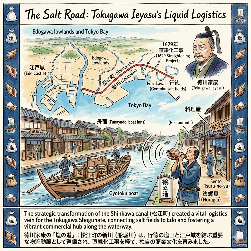
The Salt Road: Tokugawa Ieyasu’s Liquid Logistics
When Tokugawa Ieyasu assumed control of the marshy Edo lowlands in 1590, his most pressing strategic concern was not defense, but supply. Salt, the lifeblood of both the kitchen and the military, was a critical resource. To secure it, Ieyasu bypassed the treacherous and unpredictable sea routes of Tokyo Bay, envisioning instead a controlled, inland water artery. The Shinkawa canal—originally the meandering Funaborigawa—was transformed into a vital logistical vein, connecting the salt fields of Gyotoku directly to the heart of the Shogunate.
The most transformative moment for this "Salt Road" occurred in 1629. In a feat of pre-modern engineering, the Shogunate straightened the river’s path to maximize efficiency, creating the "New River" (Shinkawa) and leaving the discarded, curving segments to become what we now call the Furukawa.
"The 1629 project was a masterclass in the collaboration between natural landscape and artificial design. By utilizing micro-wetlands to forge a high-speed logistical artery, the Shogunate essentially terraformed the lowlands for the survival of the capital." — Historical Travel Stories Research.
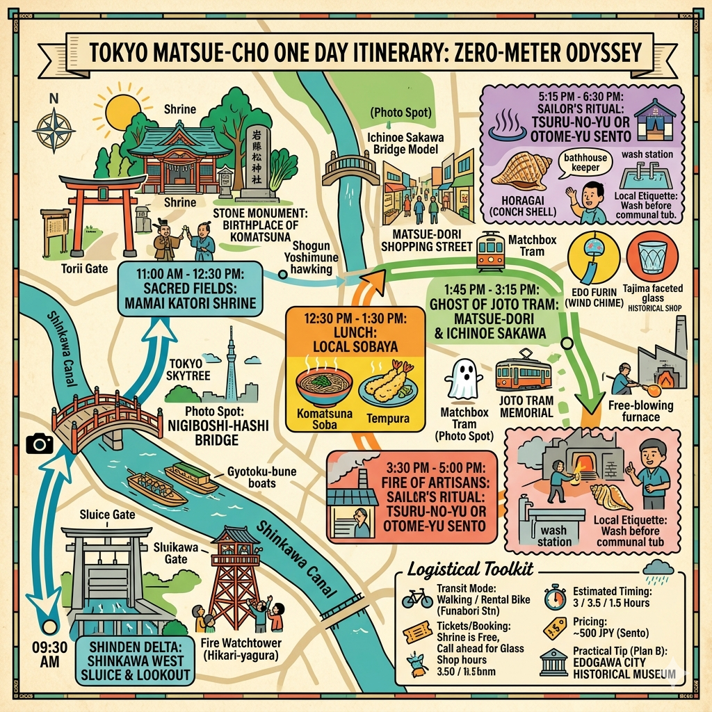
This engineering shifted the local economy from subsistence to a commercial hub. "Gyotoku boats" arrived daily, heavy with salt, miso, and soy sauce. A sensory culture soon bloomed along the banks. At local sento (public baths) such as Tsuru-no-yu, Otome-yu, and Akebono-yu, the tradition of the Horagai (Conch Shell Declaration) took root. Sailors on the river would listen for the low, resonant sound of the shell—a signal from the bathhouses that the water was hot and the doors were open. This auditory bridge connected the transient maritime world to the stable life of the shore.
While the water brought commerce, the fertile fields nourished by these same canals would soon catch the attention of the Shogunate’s highest office.
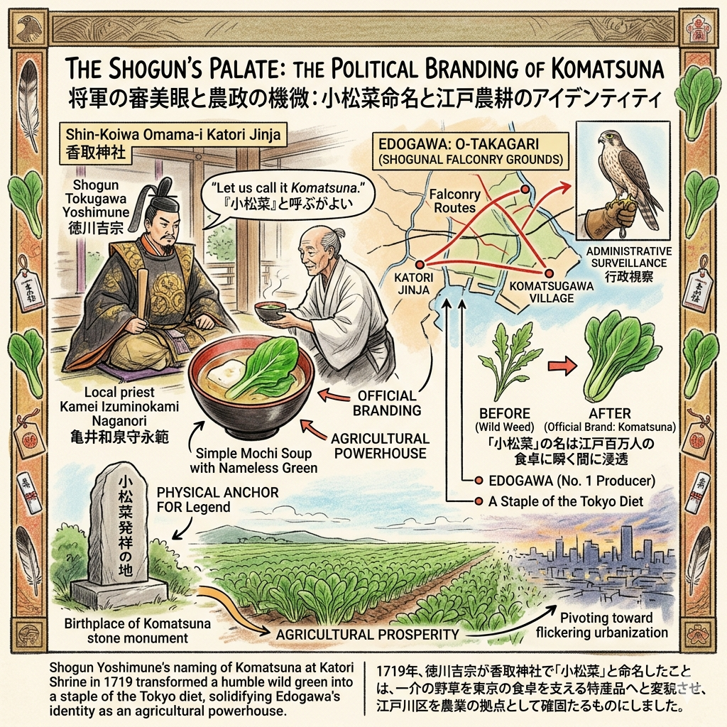
The Shogun’s Palate: The Political Branding of Komatsuna
The relationship between the Shogunate and Edogawa was further solidified through "Falconry Politics." These hunts were rarely about the pursuit of game; they were carefully choreographed exercises in administrative surveillance and rural engagement.
In 1719, Shogun Tokugawa Yoshimune visited the Shin-Koiwa Omama-i Katori Jinja during a hunting expedition. When the Shogun stopped for a meal, the local priest, Kamei Izuminokami Naganori, found himself in a precarious position. Lacking rare delicacies to serve a sovereign, he prepared a simple mochi soup, garnishing it with a vibrant, sweet green leaf found growing wild in the village. Intrigued by the flavor, Yoshimune inquired about its name. When told it was nameless, he famously declared: "Since this is Komatsugawa, let us call it Komatsuna."
This naming was a sophisticated early example of "official branding." The Shogun’s endorsement transformed a wild weed into a staple of the Tokyo diet and solidified Edogawa’s identity as an agricultural powerhouse. For the modern traveler, the "Birthplace of Komatsuna" stone monument at the shrine serves as a physical anchor for this legend—a moment where royal whim permanently altered the local biology.
From the stability of these fields, however, the district would eventually pivot toward the rapid, flickering urbanization of the early 20th century.
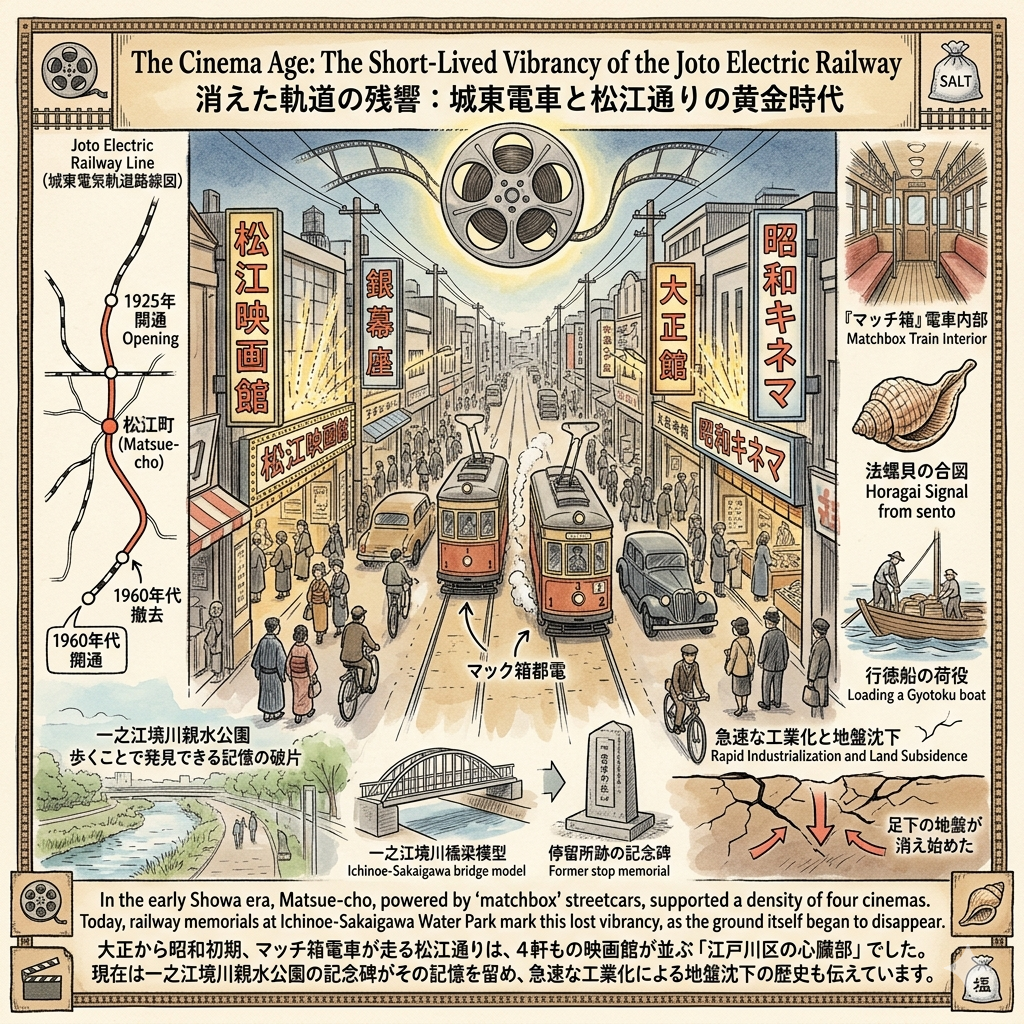
The Cinema Age: The Short-Lived Vibrancy of the Joto Electric Railway
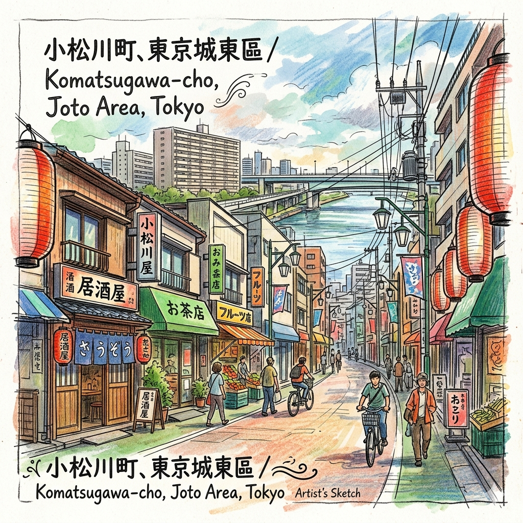
As the Taisho Democracy era ushered in a new suburban ideal, infrastructure began to dictate the life cycle of the neighborhood. In 1925, the Joto Electric Railway’s Edogawa Line opened, turning Matsue-cho into a bustling transit node. This was the era of the "matchbox" streetcars (maccibako tōden), small, rattling carriages that pumped life into the Matsue-dori shopping street.
At its peak in the early Showa period, Matsue-cho supported a staggering four cinemas—a density of culture that was unheard of for a residential district. This was the "social heart" of the area, a place where the flickering light of the silver screen mirrored the flickering progress of the age. However, this vibrancy was transient. The introduction of the trolleybus in 1952 and the rise of the automobile led to the railway’s decline. By the 1960s, the tracks were gone.
Today, the "ghosts" of this era are found at the Ichinoe-Sakaigawa Water Park, where railway memorials and bridge models mark the path where the matchbox trains once rattled. But as the cinemas flickered out and the trains stopped running, the ground beneath the residents was beginning to physically disappear.
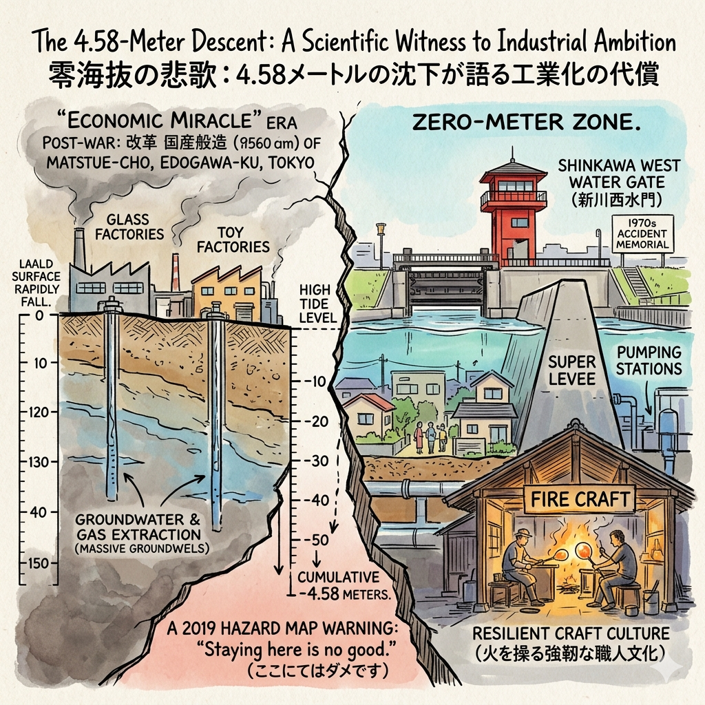
The 4.58-Meter Descent: A Scientific Witness to Industrial Ambition
The post-war "Economic Miracle" brought glass and toy factories to Matsue-cho, trading agricultural peace for industrial prosperity. But this wealth came with a hidden, catastrophic environmental debt. To fuel production, factories extracted massive quantities of groundwater and natural gas from the deep clay layers. This resulted in a geological phenomenon of profound scale: land subsidence.
By the mid-20th century, the ground was sinking at a rate of up to 20 centimeters per year. In the most severe areas, the land fell a cumulative 4.58 meters. This descent transformed Matsue-cho into a "bathtub" geography—a zero-meter zone where residents live several meters below the high-tide level, protected only by the artificial vigilance of levees and pumps.
The fragility of this existence is memorialized at the Shinkawa West Water Gate, a site that stands as a monument to the 1970s water gate accident and a reminder of the district's "defense-mode" reality. The 2019 hazard map issued a warning that echoed through the neighborhood: "Staying here is no good." The industrial prosperity of the 1960s was purchased at an irreversible environmental cost, leaving a legacy of psychological and physical vulnerability.
Yet, one industry that contributed to this crisis eventually evolved into a symbol of resilience.
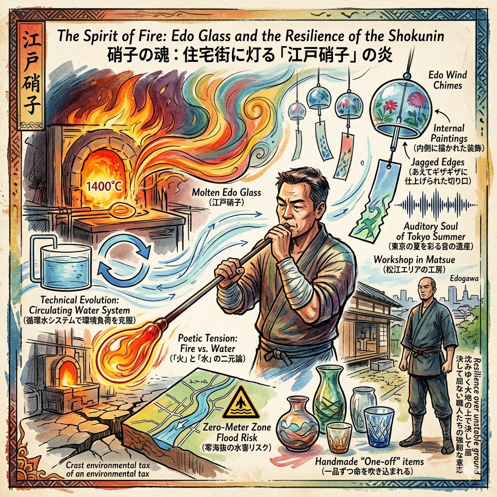
The Spirit of Fire: Edo Glass and the Resilience of the Shokunin
Edo Glass (Edo Glass) is a survivor of the Meiji transition, having thrived in Matsue due to the area’s logistical access. Today, workshops like Tajima Glass and Iwasawa Glass maintain the Shokunin (artisan) spirit, producing handmade "one-off" items that serve as a counter-narrative to the mass production that once dominated the area.
There is a poetic tension here between fire and water. While early glass factories were co-conspirators in the groundwater depletion that caused the land to sink, the surviving workshops have adapted, implementing circulating water systems to preserve the environment they once taxed. This technical evolution is the physical proof of their resilience.
Visiting the Iwasawa Glass factory shop allows the traveler to touch the "memory of fire." The Edo Wind Chimes produced here, with their distinctive internal paintings and jagged edges, create a sound that has become the auditory soul of the Tokyo summer—a delicate beauty forged on unstable ground.
Hidden Gems for the Curious Traveler
To experience the spatial continuity of Matsue-cho, two locations are essential:
- Shin-Koiwa Omama-i Katori Jinja: This is not merely a place of worship, but a site where a Shogun’s voice physically changed the local biology. The Komatsuna monument here anchors the district’s agricultural identity amidst the urban sprawl.
- Ichinoe-Sakaigawa Water Park: A stretch of greenery where the "ghost-path" of the matchbox streetcars can still be traced. It is a place to contemplate how infrastructure dictates the rise and fall of a neighborhood’s spirit.
Conclusion: A Sophisticated Reflection on the Lowland Epic
The story of Matsue-cho challenges the linear "rural-to-urban" narrative, replacing it with a "cycle of accumulation." Here, the strategic salt routes of the 17th century became the parkways of the 21st; the Shogun’s hunting grounds became the vegetable baskets of the city; and the industrial ambition that sank the earth by 4.58 meters became the catalyst for a world-class system of water defense.
The weight of those 4.58 meters is not just a measurement of soil; it is the depth of human history and the cost of compromise. Matsue-cho exists in a state of constant, quiet negotiation with the water that surrounds it and the fire that shaped its art.
When you walk these streets, are you stepping on pavement, or are you balanced on the layered choices of four centuries of survival?
For more explorations into the invisible layers of the world’s cities, subscribe to Historical Travel Stories.
Planning Your Historical Walk
- How to Get There: Access the district via Funabori Station (Toei Shinjuku Line) or Shin-Koiwa Station (JR Sobu Line).
- Recommended Tours: Follow the "ghost-path" of the salt-laden Gyotoku boats along the Shinkawa Thousand Cherry Trees. Be sure to visit the reconstructed Fire Watchtower (Hikami-yagura) and the Shinkawa Sakura-kan for historical displays.
- Accommodation Tip: Stay near the Sobu Line for seamless access to the Edogawa City Historical Museum, where the geological and cultural records of the 4.58-meter descent are meticulously preserved.
Q & A
How did a Shogun's naming of a vegetable transform Matsue?
The naming of the Komatsuna vegetable by Shogun Tokugawa Yoshimune in 1719 fundamentally transformed Matsue and the surrounding West Komatsugawa village from a humble, self-sufficient farming area into a pivotal agricultural brand for the Edo capital.
The transformation occurred through several key developments:
1. Elevation from "Wild Weed" to "Imperial Brand"Before the Shogun's intervention, the vegetable was merely a nameless, sweet green plant found growing wild around the village. During a "hawk hunting" (Takagari) trip in 1719, Yoshimune stopped at Katori Shrine. The shrine's priest, unable to offer rare delicacies, served a simple mochi soup garnished with this local green. Impressed by the taste, Yoshimune decreed it should be named "Komatsuna" after the locality, 小松川 (Komatsugawa). This official "branding" by the Shogun instantly elevated the vegetable’s status to an "imperial vegetable", making it famous across Edo's vegetable markets.
2. Economic and Agricultural InnovationThe Shogun's naming acted as an early form of official agricultural endorsement. This recognition integrated Matsue’s local produce into the Shogunate's cultural and economic system, leading to:
- Economic Growth: Demand for the vegetable surged among Edo's population of one million, bringing significant currency into the village.
- Technical Advancement: To meet the growing consumption needs of the capital, local farmers were forced to improve their cultivation techniques, transitioning from traditional subsistence farming to specialized, market-oriented agriculture.
3. Long-term Identity and Cultural LegacyThe Shogun’s naming created a lasting cultural identity for the region that persists four centuries later:
- "Birthplace" Recognition: Matsue and the central Edogawa area are still recognized as the historical home of Komatsuna, a fact commemorated by the "Birthplace of Komatsuna" stone monument at Katori Shrine.
- Agricultural Dominance: This historical head start has allowed Edogawa Ward to maintain its status as the number one producer of Komatsuna in all of Tokyo today.
In summary, the Shogun's naming transformed a "political taste" into a regional economic engine, shifting Matsue from a nameless peripheral village into a high-value agricultural hub whose produce remains a staple of the Japanese diet.
How did Matsue transition from a salt-trade artery to a residential hub?
The transition of Matsue from a vital logistics artery to a residential hub was a multi-staged process driven by infrastructure development, industrial shifts, and eventually, the necessity of environmental adaptation.
1. The Logistics Foundation (17th - 19th Century)During the Edo period, Matsue served as a critical node in the Shogunate’s strategic logistics network. The Shinkawa canal, a "Salt Road" created by redirecting and straightening the older Funaborigawa, was the lifeblood of this era,. It facilitated the transport of essential goods—primarily salt from Chiba, but also soy sauce and miso—directly to the heart of Edo. This sparked a commercial ecosystem of inns, restaurants, and public bathhouses (Sento) catering to boatmen, transforming the self-sufficient village into a commercialized settlement.
2. The Railway Boom and Urbanization (Early 20th Century)The true transition toward a "suburban residential" hub began in the early 20th century:
- Transport Revolution: In 1925, the Joto Electric Railway (Joto Densha) opened, connecting Matsue to the broader Tokyo rail network. This transformed Matsue from a rural area into a bustling commercial and administrative center.
- Cultural Hub: During the early Showa era, the area was so prosperous that the Matsue-dori Shopping Street featured "pedestrian heavens" and the town hosted four cinemas, a rarity for a suburban district at the time. Matsue even served as the administrative heart of the ward, housing the Edogawa Ward Office,.
3. Industrialization and the "Zero-Meter Zone" Crisis (Post-WWII)Following WWII, Matsue experienced a surge in industrial activity. Low land costs and water access attracted glass and toy factories,. However, this period brought a permanent change to the landscape:
- Land Subsidence: Excessive groundwater extraction by these industries caused the land to sink by as much as 4.58 meters, turning Matsue into a "Zero-meter zone".
- Loss of Logistics Function: As the canal lost its relevance to modern roads and heavy industry was eventually restricted to stop the land from sinking, the area's identity shifted away from manufacturing and trade,.
4. Transition to a Quiet Residential District (Late 20th Century)The final shift to a residential hub occurred as the geographic "center" of the ward moved:
- Infrastructure Bypass: New rail lines like the Toei Shinjuku Line and JR Sobu Line bypassed Matsue's immediate core, while the Joto Electric Railway was discontinued in the 1960s,.
- Cultural Rebranding: The Shinkawa, no longer a trade artery, was designated a historical site in 1986 and reimagined as a park through the "Shinkawa Thousand Cherry Trees" project,.
- Modern Identity: Today, Matsue is primarily a residential area that maintains its "resilient" character, utilizing dense pumping stations to manage its low elevation while preserving its artisan heritage, such as Edo Glass.
Reference and Further reading
- 新川の歴史と風景 新川と中川の合流地点(西水門) - 江戸川フォトライブラリー, accessed April 14, 2026,
- ゼロメートル地帯の水害・沈下の歴史――東京右半分の憂鬱 - 武田徹 ..., accessed April 14, 2026,
- 桜爛漫の塩の道『新川千本桜・船堀 ・江戸川区』行徳から江戸情緒満載の 新川を通って日本橋小網町へ! by 桜やよい, accessed April 14, 2026,
- 歴史探訪と温泉: 塩の道 新川, accessed April 14, 2026,
- 小松菜発祥の地(東京都江戸川区) - 史跡マップ, accessed April 14, 2026,
- 「小松菜」の名付け親は将軍・徳川吉宗?江戸時代まで遡る身近な野菜に隠された意外な歴史, accessed April 14, 2026,
- 98 江戸川生まれの小松菜 日本一, accessed April 14, 2026,
- 東京・江戸川区生まれの野菜、小松菜のゆかりの地を訪問しました!, accessed April 14, 2026,
- 小松菜の産土神 新小岩 間々井香取神社, accessed April 14, 2026,
- 郷土資料室 - 江戸川区, accessed April 14, 2026,
- 人情あふれる松江~歴史と絆が息づく特別な街~ | みなてらす ..., accessed April 14, 2026,
- 東京にあった「完全孤立の鉄道路線」とは 大河に阻まれた“一之江線” どう川越えた?, accessed April 14, 2026,
- 江戸川区一之江 一之江境川親水公園 城東電気軌道江戸川線跡。 - 太田あつし(オオタアツシ), accessed April 14, 2026,
- 2026年2月28日 城東電車百年記
- 念碑除幕式 本日開催 - 江戸川区, accessed April 14, 2026,
- 城東電車 昭和のはじめまで江戸川区内を走っていたマッチ箱都電, accessed April 14, 2026,
- 江戸硝子 | ものしょく, accessed April 14, 2026,
- 江戸川河口地域の地形と不圧地下水, accessed April 14, 2026,
- 洪水の歴史から学ぶこと, accessed April 14, 2026,
- 江戸川区郷土資料室 | 美術館・博物館 | アイエム[インターネットミュージアム], accessed April 14, 2026,
- 江戸川区の主な伝統工芸, accessed April 14, 2026