(ENG) Tamagawa Riverside Walk – 5 Hidden Stories on Tokyo’s Historic Border
A historical travel story and walking guide to Tokyo’s Tamagawa River. Discover five hidden stories about ancient riverside settlements and railway heritage to experience a slower, nostalgic side of the metropolis.

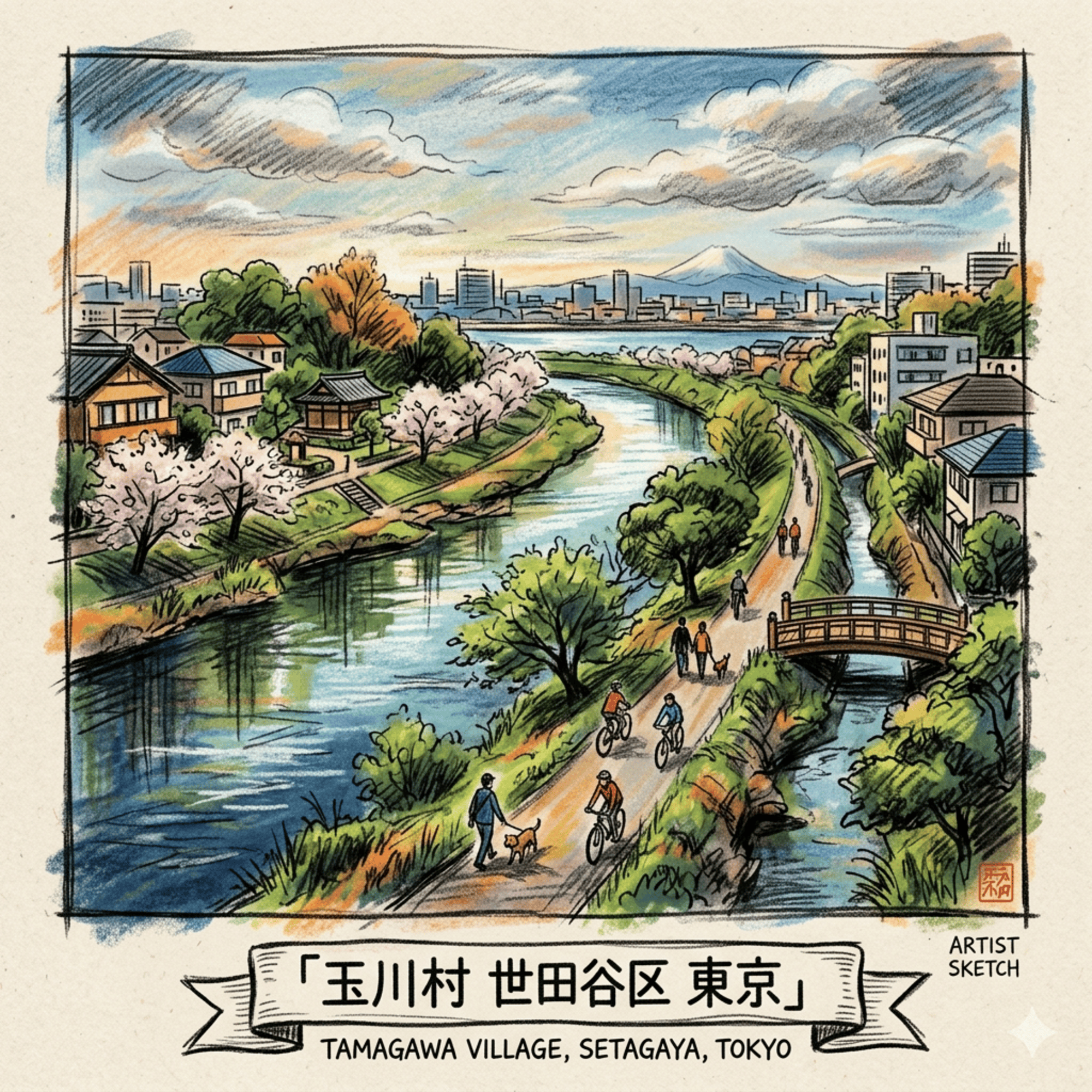
This is a historical travel story and walking guide to the Tamagawa River, a scenic waterway shaping the border of Tokyo. Through five hidden stories, it explores ancient riverside settlements, railway heritage, and local everyday life to offer a fresh cultural perspective on this historic river. Readers will discover a slower, nostalgic side of Tokyo away from the neon crowds.
The Rural Ghost in the Urban Machine
The administrative reorganization of 1889 served as a formal catalyst for the transformation of the southern Setagaya plateau, merging the agrarian hamlets of Okusawa, Oyama, Todoroki, Kaminoge, Norada, Yoga, Seta, and Shimonoge into the singular entity of Tamagawa Village. This "peripheral rural village" functioned as a vital productive belt, supplying the burgeoning Tokyo market with essential produce. While the 1932 "Great Tokyo" expansion officially dissolved the village into the urban administrative framework of Setagaya Ward, its geographic essence was not eradicated; it was merely submerged. For the historical geographer, the modern landscape is a site of "travelable history" where the original field boundaries and irrigation logics continue to dictate the modern street grid. This journey observes the spatial continuity of a landscape that was never truly erased, but rather folded into the complex machinery of metropolitan expansion.
Listen to the historical stories told in detail (For subscribers only)
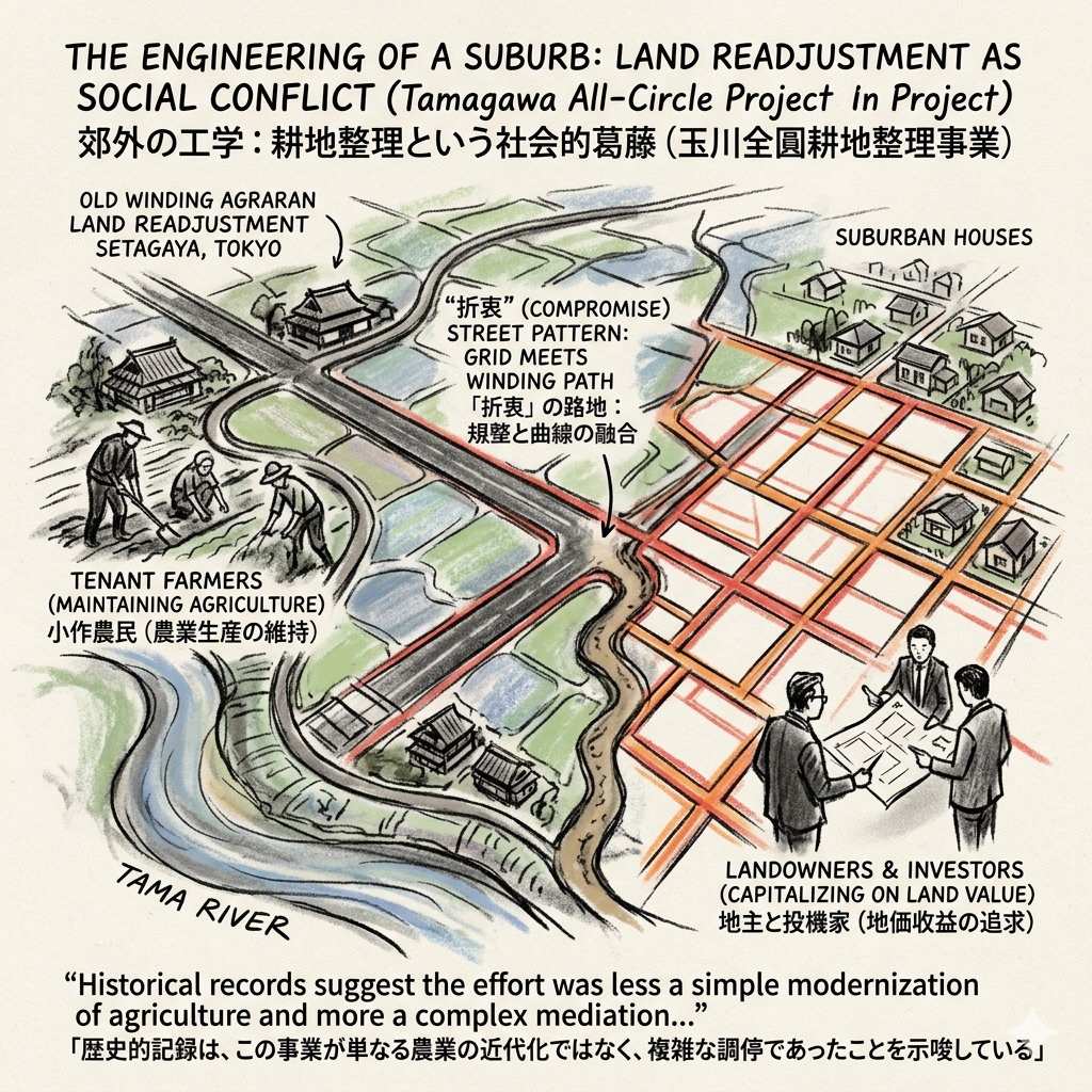
The Engineering of a Suburb: Land Readjustment as Social Conflict
The transition of Tamagawa from a productive agrarian landscape to a residential suburb was facilitated by the "Tamagawa All-Circle Land Readjustment Project" (1924–1954). This monumental undertaking reconfigured the physical earth to accommodate the encroaching logic of the city, serving as the infrastructural bridge between the village’s past and its suburban future. However, this reorganization was not a neutral technical exercise; it was a profound "field of interest adjustment" (利害調整).
The project functioned as a contested arena where tenant farmers, intent on maintaining the agricultural productivity of the soil, clashed with landowners and speculative investors eager to capitalize on the rising value of residential land. The resulting "折衷" (compromise) street patterns—where rigid, planned thoroughfares often terminate abruptly into older, winding paths—serve as a physical transcript of this class struggle.
“Reflecting on the 1924–1954 project, historical records suggest the effort was less a simple modernization of agriculture and more a complex mediation between the agrarian traditions of the village and the emerging requirements of the suburban commuter class.”
This structural compromise laid the groundwork for a hybrid urban form, transitioning from the management of the soil to the extraction of the riverbed itself.
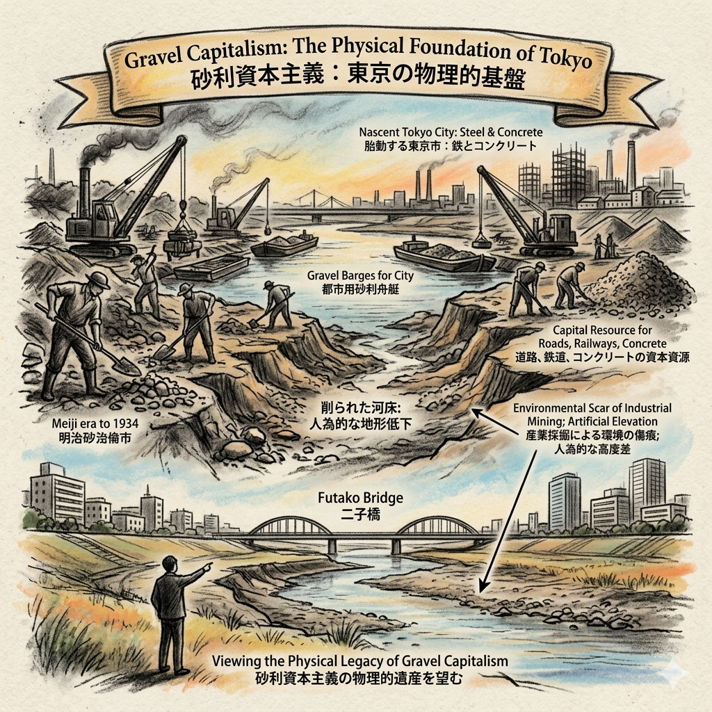
Gravel Capitalism: The Physical Foundation of Tokyo
The Tama River was historically far more than a scenic boundary; it was a critical "capital resource" that provided the literal material for Tokyo’s modernization. Between the Meiji era and 1934, the river was defined by "Gravel Capitalism." The stones and sediment harvested here were the primary components for the roads, railway ballasts, and concrete skeletons of the central metropolis. This industrial era reached a definitive turning point in 1934, when the government banned gravel extraction in the reaches downstream of the Futako Bridge to protect the integrity of the riverbed and flood defenses.
The environmental legacy of this extraction remains visible in the "削られた河床" (scoured riverbed). The dramatic elevation differences observed today between the riverside and the surrounding plateaus are not natural topographical features, but the permanent scars of industrial mining.
“Historical accounts of the river’s industrial peak remind us that the waterside was once a site of grueling labor and resource extraction rather than a space for leisure; it was the industrial heart that pumped the materials of the village into the veins of the city.”
As the river’s material resources were depleted, the socio-economic focus shifted toward the branding and administrative categorization of the land.
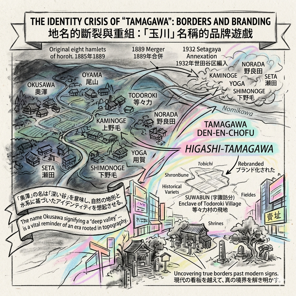
The Identity Crisis of "Tamagawa": Borders and Branding
The administrative mergers of 1889 and 1932 created a layered identity crisis for the original eight hamlets. As the identities of Okusawa, Oyama, Todoroki, Kaminoge, Norada, Yoga, Seta, and Shimonoge were consolidated, the original boundaries began to fade beneath a new marketing veneer. Modern names such as "Tamagawa Den-en-chofu" or "Higashi-Tamagawa" function as branding layers that often obscure older, more complex geographic realities, such as "tobichi" (enclaves). A prime example is Higashi-Tamagawa, which originated as an enclave of Todoroki Village known as "Suwabun" (字諏訪分).
To uncover the true historical borders, one must look past modern real estate signage toward the orientation of ancient shrines and neighborhood markers. These sites often preserve the original village centers that predated the administrative mergers.
“The name Okusawa, signifying a ‘deep valley’ as viewed from the downstream of the Nomikawa River, serves as a vital reminder of an era when local identity was rooted in natural topography and hydrology rather than administrative convenience.”
These linguistic remnants persist even as the land itself transitioned into a specialized form of urban agriculture.
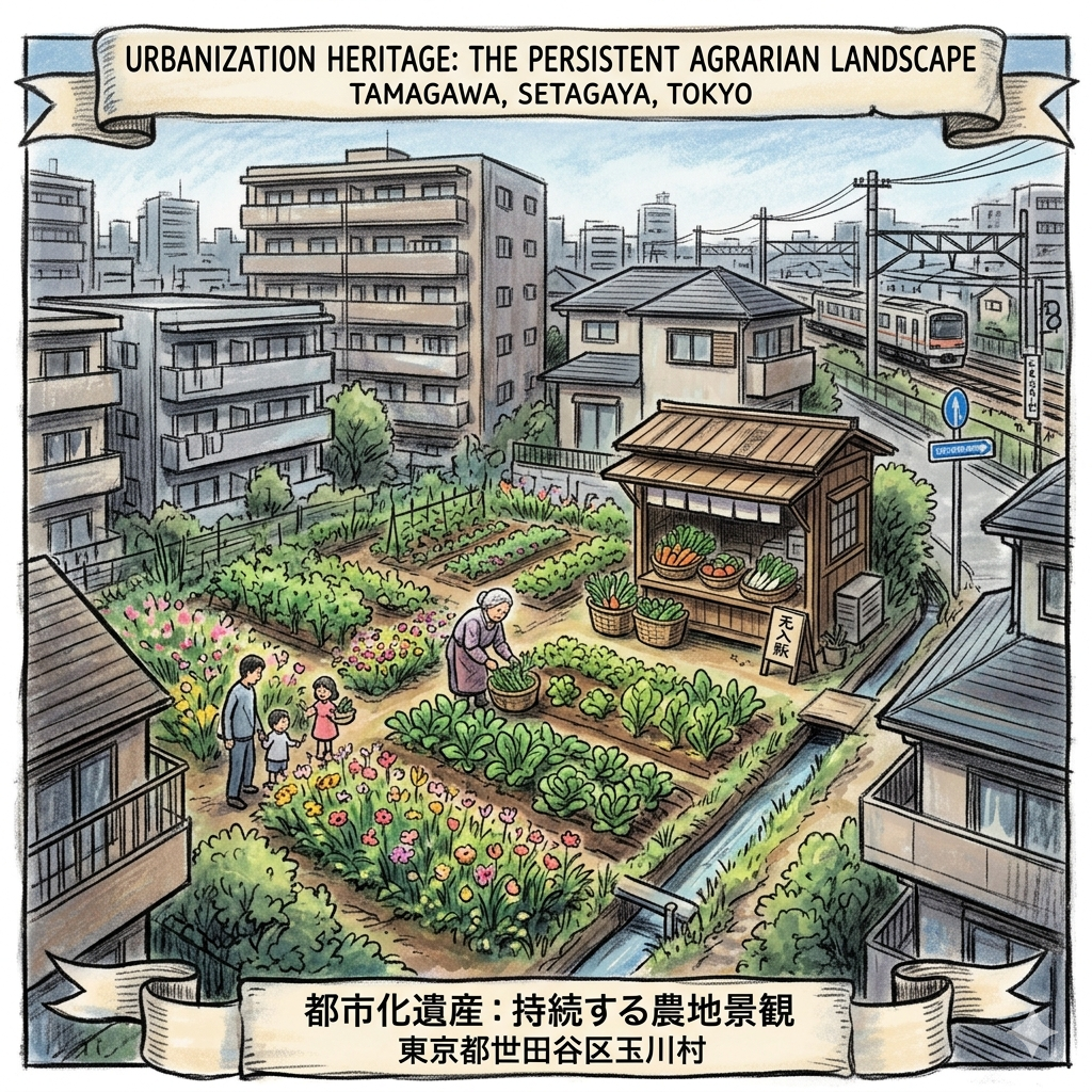
Urbanization Heritage: The Persistent Agrarian Landscape
Unlike many global suburbs where residential growth necessitates the total elimination of agriculture, Tamagawa retains what is known as "Urbanization Heritage" (都市化遺産). The survival of small-scale vegetable plots amidst the dense residential blocks of Setagaya is a significant geographic anomaly. Historically, these fields were the pantry of the Edo market, and today they represent a site of long-term economic resilience.
Setagaya Ward has increasingly recognized these surviving plots not as development gaps, but as a vital "regional resource." For the historically minded traveler, a field of spinach or flowers is a site of active preservation—a resistance to total suburbanization where families have adapted by shifting to direct-sales and experiential farming. This agrarian persistence ensures the village’s original economic pulse remains discernible, protected by the very water infrastructure that governs the region’s safety.
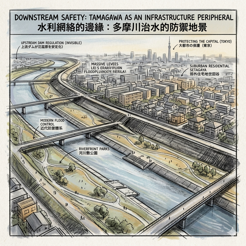
Downstream Safety: Tamagawa as an Infrastructure Peripheral
Though Tamagawa Village was not a primary intake site for Tokyo’s water supply like the upstream hamlets of Hamura, it occupied a critical role in the city’s "Water Security" network. As a downstream peripheral zone, the village’s spatial layout was dictated by the requirements of modern flood control.
The landscape we see today—expansive riverfront parks and massive levees—is a testament to the engineering required to stabilize the floodplain for residential use. The straightening of the river and the regulation provided by the upstream Ogouchi Dam allowed the "rural" Tamagawa to be reconfigured into the "safe" suburban Setagaya. This environment is less a natural riverbank and more a sophisticated piece of urban safety infrastructure, designed to protect the capital at the village's expense.
The Hidden Gem: A Walk Through the Layers
To experience the convergence of these historical layers, one should visit the transition zone between the rigid, 20th-century grid of the Okusawa land readjustment area and the organic, meandering paths of the original Todoroki hamlet. It is at this invisible border where the conflict between the planned city and the ancestral village is most physically palpable.
Philosophical Reflection: The Palimpsest of the Suburbs
Understanding a city requires more than a survey of its landmarks; it demands an archaeology of the mundane. The evolution of Tamagawa—defined by the friction of land readjustment, the industrial scars of gravel capitalism, the rebranding of ancient enclaves, and the strategic persistence of urban farms—reveals that the "rural" is never truly lost. It is simply folded into the urban fabric, like a palimpsest where the original script bleeds through the modern text.
When we traverse the streets of southern Setagaya, we are moving through a landscape that has functioned simultaneously as a productive field, an industrial resource mine, and a branded residential ideal. The suburb is not a hollow space of modern convenience; it is a complex social and economic project that remains in constant negotiation with its agrarian past and its metropolitan future. The "rural ghost" is the very foundation upon which the city stands, visible in the height of a levee or the sudden curve of a street. As you navigate these layers, consider: How does the original village, though hidden, still dictate the rhythm of your movement through the modern city today?
Plan Your Historical Walk
For those seeking to explore the hidden geography of Tamagawa, the following logistical details are essential for a self-guided study.
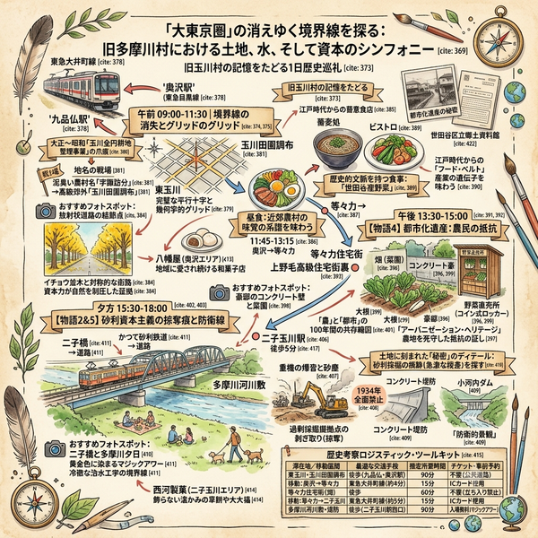
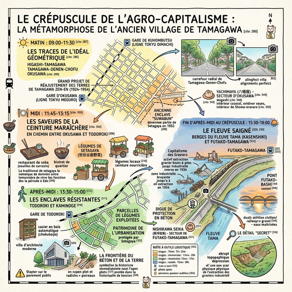
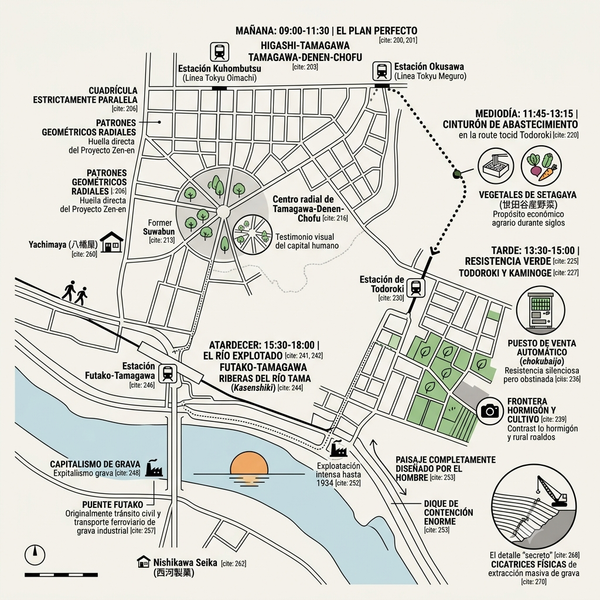
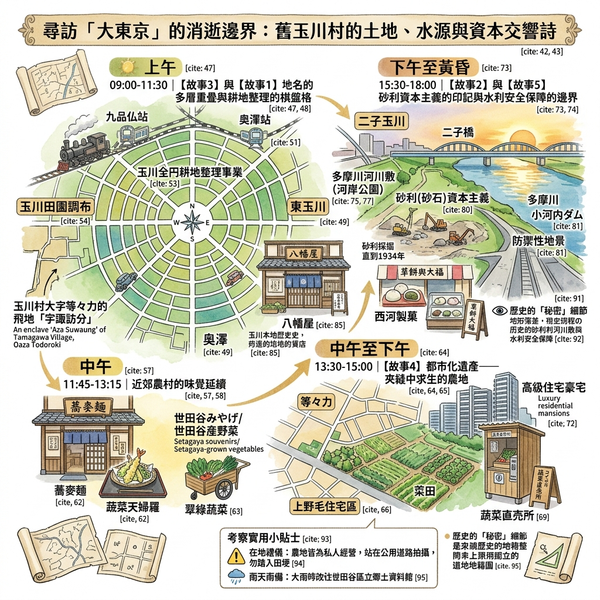
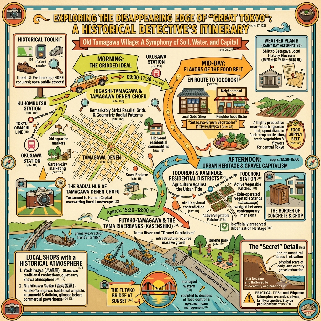
- How to get there: The primary artery for historical exploration is the Tokyu Oimachi Line, which connects the original village string from Okusawa to Futako-Tamagawa. The Tokyu Den-en-toshi Line provides access to the higher plateaus of Yoga and Seta.
- Recommended accommodation areas: Futako-Tamagawa serves as an ideal base, offering immediate access to the riverfront infrastructure and the nearby historical village centers.
- Recommended tours nearby:
- Todoroki Valley: Explore the only natural valley in Tokyo's 23 wards to understand the original topography that governed the eight villages.
- The Urbanization Heritage Route: A walk from Okusawa to Yoga to observe surviving farm plots and the irregular street patterns where the land readjustment project met the old village paths.
To receive more deep dives into the hidden geography of the world's great cities, subscribe to the Historical Travel Stories newsletter.
Q & A
How did the Tamagawa land adjustment projects shape modern Tokyo?
The Tamagawa All-Area Land Readjustment Project (玉川全円耕地整理事業), which took place between 1924 and 1954, was one of the largest land adjustment initiatives in the Tokyo suburbs and played a foundational role in shaping the modern urban landscape of southern Setagaya.
According to the sources, these projects influenced the development of modern Tokyo in the following key ways:
1. Establishing the Physical Framework of Modern Residential Areas
The project covered the area formerly known as Tamagawa Village, which includes present-day Futako-Tamagawa, Yoga, Kaminoge, Todoroki, and Okusawa. While the initiative was ostensibly for agricultural modernization—such as improving irrigation—it was designed with future urbanization and road networks in mind. Today, the unusually regular street patterns and the layout of residential and commercial zones along the Tokyu Oimachi Line and Kanpachi-dori are direct physical legacies of this long-term land restructuring.
2. Facilitating the Transition from "Farming Village" to "Urban Suburb"
Before the 1920s, Tamagawa Village was a "suburban farming village" that supplied vegetables and flowers to the Tokyo market. The land adjustment projects served as the "groundwork" for supplying urban housing, turning productive farmland into real estate. This process involved complex negotiations between farmers, who wanted to maintain their land, and landlords or investors, who sought to profit from rising land prices and residential sales.
3. Integration into "Greater Tokyo"
The land adjustment projects coincided with the administrative expansion of Tokyo. In 1932, Tamagawa Village was officially incorporated into Tokyo City as part of Setagaya Ward. This integration, supported by the ongoing land restructuring, allowed the area to be absorbed into the "Greater Tokyo" administrative and economic framework, effectively turning a rural periphery into a central part of the city's residential belt.
4. Creation of a "Capitalized" Urban Space
The sources suggest that these projects represent the "capitalization" of land. Just as the gravel mining history (discussed previously) treated the river as a source of industrial capital, the land adjustment projects treated the soil itself as a capital asset to be reorganized for the benefit of a growing metropolis. This shift redefined the regional identity from a nature-based agricultural community to a brand-driven suburban residential area.
5. Preservation of "Urbanization Heritage"
Despite the heavy development, the projects left behind a "mixed" landscape where remnants of old alleys and small pockets of farmland still exist within the modern grid. Setagaya Ward now recognizes these traces as "urbanization heritage," viewing them as local resources that tell the story of how Tokyo expanded and how the relationship between its inhabitants and the land evolved over the 20th century.
Where can I still see the street patterns from the land adjustment?
You can still observe the physical traces of the land adjustment projects in the following locations and visual forms:
Primary Locations
The street patterns resulting from the Tamagawa All-Area Land Readjustment Project are most visible in the southern part of Setagaya Ward, which corresponds to the former territory of Tamagawa Village. Specifically, you can see these patterns along:
- The Tokyu Oimachi Line (東急大井町線).
- Kanpachi-dori (環八通り/Ring Road No. 8).
- The residential and commercial districts of Futako-Tamagawa, Yoga, Kaminoge, Todoroki, and Okusawa.
What to Look For
According to the sources, the modern landscape in these areas is a cumulative result of the land adjustment and post-war redevelopment, characterized by:
- Unnaturally regular street patterns: The grid-like or highly structured layouts in these neighborhoods are a direct result of the project’s goal to prepare the land for future housing and road networks.
- Hybrid traces: You can find a "folding" of history where alleys that retain old plot boundaries exist alongside the newer, more rigid street blocks.
- Scattered farmland: Small pockets of fields, greenery, and unmanned vegetable stands still dot these residential areas. These are not just "random" patches of dirt but are the direct remnants of the original agricultural land use that the adjustment project sought to modernize before the area was fully urbanized.
- Topographical changes: In areas like Futako-Tamagawa, the height differences between the riverbed, the embankments, and the residential terraces reflect the historical "shaping" of the land for both flood control and urban expansion.
Setagaya Ward officially categorizes these remaining traces as "urbanization heritage" (都市化遺産), viewing the irregular pockets and regular street grids as a regional resource that documents the transition from a farming village to a modern suburb.
Reference and Further reading
First layer – Primary and institutional data
- 世田谷区「『地域資源』としての『都市化遺産』」報告書(PDF)— 玉川村を含む編入と都市化遺産の位置づけ。
- 東京都・世田谷区行政資料:市域編入関連文書(オンライン要約レベル。詳細は都立公文書館・世田谷区郷土資料室での閲覧が必要)。さらに公文書レベルの調査を推奨。
- 国土交通省関東地方整備局・多摩川水系関連資料(多摩川流域概要・改修史のPDF)。
- 稲城市公式ウェブサイト「多摩川の砂利採掘」— 下流域砂利採掘史の行政的まとめ。
- 世田谷区公式サイト「地名の由来(奥沢・玉川田園調布・東玉川)」— 明治以降の地名・行政区画変遷を整理。
- 行政区画・住居表示施行に関する区の公報・議会資料(詳細は区立郷土資料館・区政資料室での閲覧を要す)。
- 世田谷区「『地域資源』としての『都市化遺産』」— 都市化遺産としての農地・農業の位置づけ。
- 東京都地質調査業協会「多摩川と玉川上水・小河内ダムの歴史」図解(技術ノート)。
- 国土交通省・多摩川水系関連資料(流域の自然状況・治水事業の概要)。
The second layer – academic secondary literature
- 「大都市近郊における耕地整理と地域社会」(東京大学学位論文、玉川村対象)。
- 「大正・昭和前期の東京近郊における耕地整理組合経営」(玉川全円耕地整理事業に関する研究)。
- 東京都市大学関連資料「玉川全円耕地整理事業」解説。
- 河川工学・都市インフラ史の学術論文(多摩川に特化したものは要文献検索。現段階ではオンラインで直接特定できるものは限定的。さらなるアカデミック・データベース利用推奨)。
- 都市地名学・地理学の文献(東京南西部の地名変遷研究)。オンラインで直接玉川村のみを扱うものは限定的であり、さらなる学術データベース調査が必要。
- 東京大学学位論文「大都市近郊における耕地整理と地域社会」— 玉川村の近郊農村としての性格、商品作物栽培の歴史。
- 農林水産省・農研機構系レポート「都市・都市近郊農業における構造変化と立地別の特徴」— 都市農業の一般的特徴と統計的背景。
- 水道史・河川工学史に関する学術書(玉川上水・多摩川治水を扱うもの)。オンライン上の断片的情報のみでは玉川村との関係が十分に明らかではなく、図書館レベルでの文献調査が望ましい。
Third layer – Supplementary information
- 都市近郊農業の構造変化に関する農林水産省系レポート(都市・都市近郊農業の構造変化と立地別特徴)。玉川村を直接扱わないが、近郊農業一般の背景理解に有用。
- 三井住友トラスト不動産「『多摩川』での砂利採堀と『等々力緑地』」— 多摩川砂利の歴史と利用先を扱う歴史記事。
- ローカル・ヒストリー系講演会資料(旧玉川村や自由が丘周辺の歴史を扱う講演告知記事など)。→ 講演そのものの資料は別途主催団体への照会が必要。
- 地域農家への聞き取り・ローカルメディアの農家紹介記事など(現段階ではオンラインで体系的に集約された一次資料は乏しく、現地調査と聞き取りが重要)。
- 河川史を扱う一般向け解説・長文記事(玉川上水や多摩川ダムの歴史を紹介するもの)。