Tin Shui Wai, Hong Kong: A Marsh Written Into Existence
Discover the hidden history of Tin Shui Wai through a slow walk from the Ming-dynasty Tsui Sing Lau Pagoda to colonial reclamation records, fish ponds, and the modern Wetland Park.

 Lawrence
Historical Travel Stories · English edition
💡 Join a community of discerning travelers. Simply enter your email to instantly unlock audio guides and one-day itineraries, and carry our exclusive historical walking maps with you on your journey.
This is a historical travel story and walking guide to Tin Shui Wai, a modern new town in Hong Kong built upon former tidal mudflats and fish ponds. From the ancient Ping Shan Tsui Sing Lau Pagoda to the colonial-era reclamation deeds and the vast Hong Kong Wetland Park, this walk explores how the landscape shifted from salt pans to an engineered ecosystem. Readers will discover the deep geo-historical layers, hydraulic transformations, and everyday stories that shaped this western New Territories community.
In the Hong Kong Wetland Park, a saltwater crocodile named Pui Pui lives behind a thick wall of acrylic. Nobody knows where she came from. In November 2003 she was seen in a muddy channel off the Shan Pui River in Yuen Long, and it took seven months, a crocodile hunter flown in from Australia and the government’s own conservation officers to catch her. Her outdoor enclosure measures seventy-two square metres, and the park says it was sized for the animal she had not yet become. Beyond the glass the reserve runs flat to the horizon: reeds, mangrove, still water. It looks as though it has always been here. Almost nothing in this landscape has been here for a hundred and ten years.
1. The bay no one registered
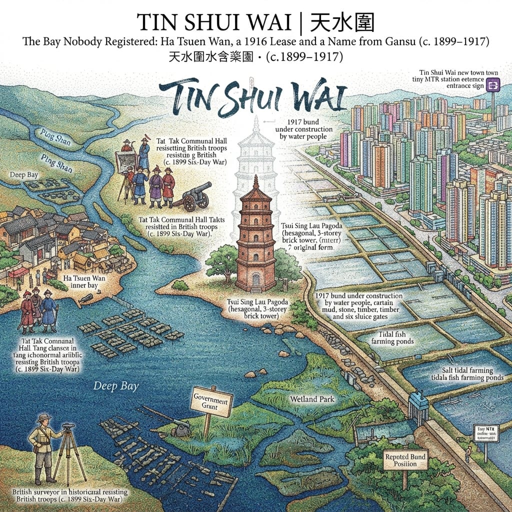
Before the twentieth century the place now called Tin Shui Wai 天水圍 was a tidal bay, Ha Tsuen Wan 廈村灣, an arm of Deep Bay. Two rivers coming down past Ping Shan 屏山 and Ha Tsuen 廈村 laid their silt there. Villagers from Mong Tseng Wai 輞井圍 and Ha Tsuen had farmed oysters on the flats for centuries.
In April 1899, when Britain took over the New Territories, the Tang 鄧 clans of Ping Shan and Ha Tsuen were among those who fought it. A hall in Ping Shan is believed to have been one of the places where the resistance was planned, and the artillery the clan bought that year still stands outside the Tang Ancestral Hall. At least five hundred villagers died in what became known as the Six-Day War.
Maurice Yip, a scholar at the University of Lausanne who has worked through the colonial files, reports that when the land was surveyed in the early 1900s the villagers did not declare title to the flats, either from fear of taxation or from trust in rights the Qing had recognised. In law, the bay became Crown land.
The Bay Lost To Paperwork
In 1916 a family named Zhao 趙, from Taishan in Guangdong, formed the Luen Tak Company 聯德公司 and applied to reclaim it. The government leased them about 490 hectares at a low rent. Both the Hong Kong Bird Watching Society’s oral-history project and Yip say the government meant to use an outsider to check Tang power in the western New Territories; the Tang oyster beds and boat traffic ended with the grant. That is a historian’s reading. I have seen no document that states the motive.
In the winter of 1917 the company hired boat people who worked around Deep Bay and had them build a bund across the river mouth: more than 150 metres long, set on a stone footing, raised by hand in layers of mud, braced with planks, fitted with six sluice gates. A paper written for the Executive Council in 1980 records the same thing in a sentence: the land was made about sixty years earlier by building a bund across the bay.
The Zhao family named the new ground Tin Shui Wai. Tin Shui, Tianshui, is a well-known Zhao hall-name. A tradition attributed to the late Heung Yee Kuk chairman Lau Wong-fat 劉皇發 says the name honours Tianshui in Gansu, the ancestral seat of the Song dynasty’s founder, Zhao Kuangyin. It is tradition, not record. Another account says the name describes ponds that reflect the sky. Nothing supports that either.
What can be said with confidence is smaller. A family from Taishan took a place-name from Gansu and set it down on a mudflat at the edge of the South China Sea.
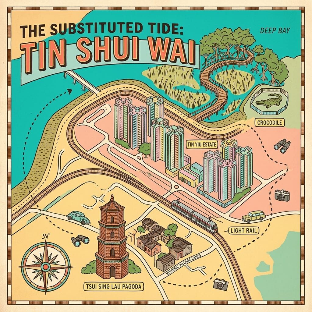
The Tang had once built a pagoda at this same estuary. Tsui Sing Lau 聚星樓, the Pagoda of Gathering Stars, is by the Ping Shan genealogy the work of a seventh-generation ancestor, Tang Yin-tung 鄧彥通, around the Hongwu reign of the 1300s. Tradition says it stood at the Deep Bay river mouth to keep out northern ill-fortune, prevent floods and draw literary success to the clan’s sons. (One account dates it to about 1486; the question is open.) The pagoda is still there, hexagonal, brick, about thirteen metres high, three storeys. The estuary it was built to watch has since been enclosed by someone else.
Holographic Sensory Cue: What you can see at the site is the grey-green brick of the pagoda, its hexagonal body and the diamond-shaped brick eaves under each storey, and the trees around it.
2. The village on the dam
Most of the boat people who built the bund stayed on it. They put timber houses along its top and lived by catching shrimp and fish, twisting rope and taking whatever day work came. The Zhao family’s villa, a granary and a school stood on the bund. Former residents remembered three settlements: Luen Tak Lei 聯德里 on the bund, the largest, and two others, Chung Wo Lei and Pak Sha Lei. Luen Tak Lei had its own flower-cannon association. In Hong Kong such associations are usually tied to Tin Hau festivals, but I found nothing that says this one was.
Until the Second World War the new land grew salt-tolerant grass or served as rough tidal ponds. Under the Japanese occupation, mainland migrants who knew how to farm reclaimed fields became the labour for salt-water paddy, and the company, with food short, dug channels, strengthened the embankments and divided the land into numbered blocks. Tenants took their rice to the company to be milled and bought, and spread burnt oyster shell on the fields to sweeten the soil.
After the war the southern half turned to freshwater rice and ponds began to appear near the bund. In 1955 the company leased everything to a middleman for ten years. When the lease ran out in 1965 it preferred tenants with the capital to farm fish, and many rice farmers lost their land. By 1971 nearly the whole lot was ponds. For a decade and a half it was an important source of freshwater fish for Hong Kong, with some hundreds of households, many arrived in the 1960s and 1970s, living in timber huts beside ponds and ducks.
The Village Built On A Dam
In the early 1980s the government announced a new town. In 1986 the last pond-farming families left. The ponds were drained and filled, and the glut of fish sent prices down. Most of the families went to Long Ping Estate 朗屏邨 in Yuen Long. A man called Mr Chan, who had lived on the bund, remembered that after the place was taken back it stood empty for years before it was cleared, and that he never forgot the granary and the school. He thought them handsome.
The oral-history project says the bund became part of the Wetland Park. One account puts it near the park’s mangrove boardwalk. That has not been checked.
Holographic Sensory Cue: In the park you can see mangrove, reedbeds and wading birds. Where the bund ran is not confirmed, and the cue should not claim it.
3. The small question
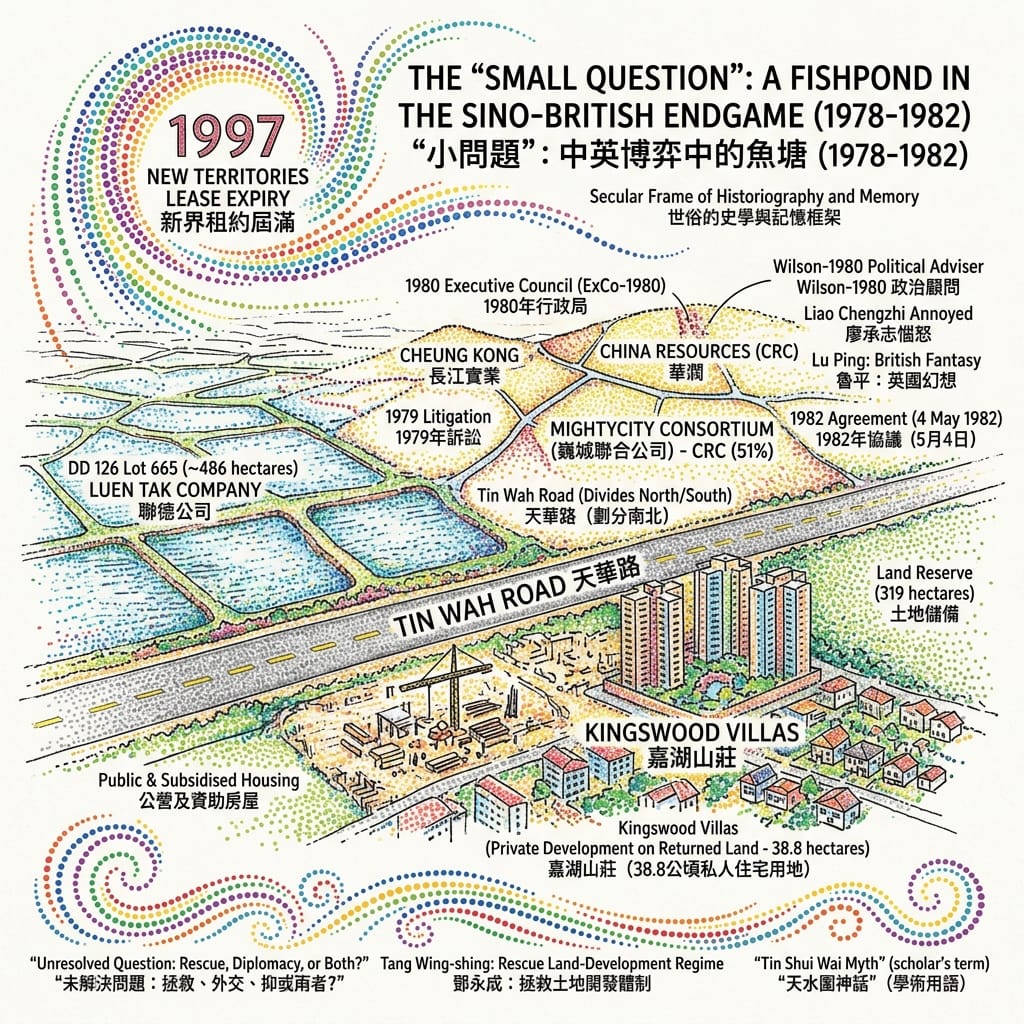
The ground belonged, in law, to the Luen Tak Company: Lot 665 in Demarcation District 126, about 486 hectares, held by trustees for the shareholders. The company’s ownership had been fought over for years and was settled by litigation in 1979. From 1978 Cheung Kong 長江實業, Li Ka-shing’s company, began buying shares. It brought in Wheelock and Trafalgar and then, in 1979, China Resources 華潤, for whom it was the first venture into property. The four formed a consortium, Mightycity 巍城, with China Resources holding 51 per cent.
On 7 January 1980 the consortium’s solicitors wrote to the government. Their clients had bought, or agreed to buy, 591 of the company’s 720 shares, about 95.97 per cent, and meant to apply for a new town. In September the Governor’s Political Adviser, David Wilson 衞奕信, told London that press stories of China Resources “buying” the land for HK$600 million described little more than a legal technicality, since it already held 51 per cent of the company that owned it.
What follows is Yip’s reconstruction from British and China Resources files. London saw in the proposal a possible opening on the problem that the New Territories leases would run out in 1997. A consortium representative suggested paying the land premium over twenty years and leaving out the usual expiry clause. In December 1980 word came from Beijing that Liao Chengzhi 廖承志 was annoyed that China Resources had not consulted the leadership. A Xinhua official told the British in January 1981 that the company had no authority to seek a special lease. Lu Ping 魯平 later wrote that the idea was a British fantasy. London’s hopes cooled; the Hong Kong government went on, because a developer backed by China, working on a long project in the New Territories, was worth having.
The Fishpond That Almost Saved Hong Kong
The Executive Council approved an agreement on 4 May 1982 and China Resources’ managers signed it for Mightycity on 29 July. The government bought about 488 hectares for HK$2.258 billion. A town for about 135,000 people would be built on 169 hectares of it. The developer got 38.8 hectares back for private housing and commerce, at a premium of HK$800 million. Another 130.2 hectares went to public and subsidised housing and 319 hectares were kept in reserve.
Yip, citing China Resources’ archives, says Margaret Thatcher told Deng Xiaoping, before the Sino-British talks began, that the question of Tin Shui Wai had been settled. This rests on a single source and wants checking.
The Foreign Office filed its Tin Shui Wai papers under “Future of Hong Kong”, not under urban development. The government told the public nothing about 1997.
Two accounts of all this compete. The geographer Tang Wing-shing 鄧永成 of Hong Kong Baptist University argues that the government rescued a failing land speculation to protect the land-development system. Yip argues that “rescue” is the wrong word and that the government pursued the project for political advantage from the start. I do not choose between them.
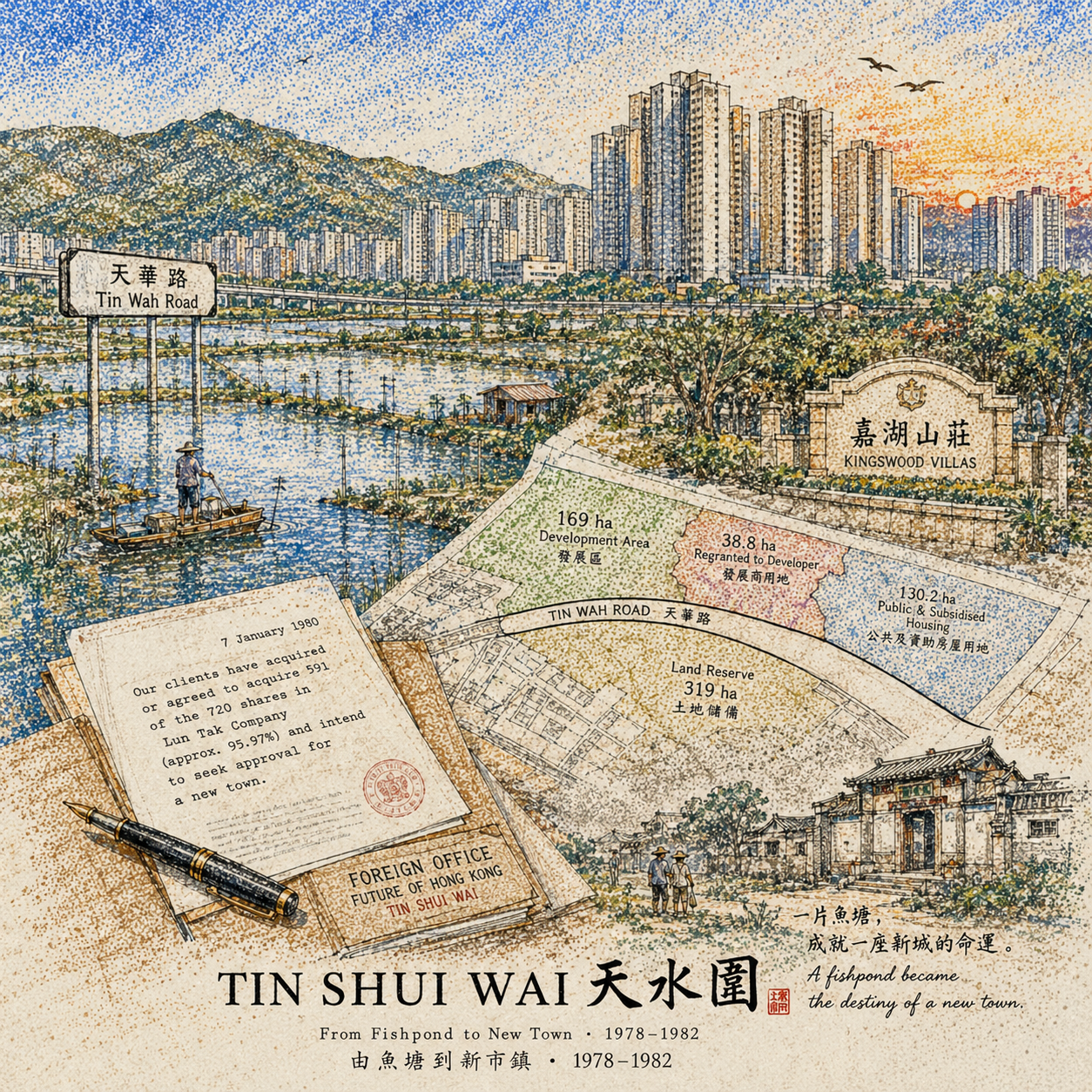
4. A town built backwards
The main engineering began at the end of 1987. In April 1992 the first tenants moved into two public estates, Tin Yiu and Tin Shui, and soon afterwards into the private Kingswood Villas 嘉湖山莊. The Light Rail link opened in early 1993, as did the first three parks. A Foreign Office file of 1991 had expected the first residents by December 1991. The same file records the developer’s claim that the government had been late handing over land, and its questions over who was liable if the Light Rail missed the first intake, for marble caverns found under the site, and for community facilities arriving in step with housing.
The 1982 agreement contained a clause: the government’s “neighbourhood shops” must not make the developer’s commercial space unviable. The clause was revoked in 2002. The government has since said it applied only to the southern 169 hectares. It is reported that in 1988 the government planned a permanent market at Area 33, the developer objected, the plan was reduced to a temporary market, and the permanent one was never built. The site is now a bus terminus beside Central Park Towers.
The Town That Banned Shops
On 11 April 2004 a family in the district was destroyed. The Director of Social Welfare set up a three-person review panel, and its report came out that November. On 14 October 2007 it happened again at Tin Yiu Estate, and the Legislative Council debated it on 7 November. The district got a Family and Child Protective Services Unit, three Integrated Family Service Centres and twelve new welfare measures in three years. By then the district had a name that stuck: the City of Sadness. I have not given the people’s names or any detail, and I will not.
The film-maker Ann Hui 許鞍華 answered the name with two films. The Way We Are (2008) follows a mother and her son; it opens on close-ups of wetland, includes an old photograph of Tin Shui Wai before the town, and ends with 1960s footage of families at a Mid-Autumn gathering in Victoria Park. Night and Fog (2009) is based on the 2004 case and was made after talking with survivors.
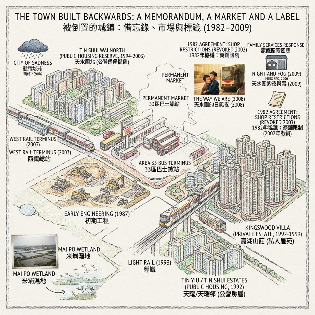
5. The replacement marsh
In 1995 the government listed part of Deep Bay as a wetland of international importance. In 1997 a study confirmed the ecological value of the fishponds, and the Town Planning Board then required that development around the bay cause no net loss of wetland. The source for this is the oral-history project; it needs checking against the Board’s own papers. A 64-hectare ecological mitigation area was set aside in the north-east of the new town to compensate for habitat lost and to keep the dense town apart from the Mai Po marsh. In 1999 the government decided to make it a wetland park. The Hong Kong Wetland Park opened on 20 May 2006, with a visitor centre of 10,000 square metres and a 60-hectare reserve.
Hong Kongs Fugitive Crocodile
Pui Pui was caught on 10 June 2004, named in a competition that drew some 1,600 entries, kept for two years at Kadoorie Farm and moved to the park on 15 August 2006, 1.75 metres long and 19.5 kilograms. Crocodiles are not native to Hong Kong. The reports at the time said she had probably escaped from a farm or been a discarded pet; nobody knows. She was found in Yuen Long, not in Tin Shui Wai.
Here is a reading of my own, and it is not settled. The fishponds that the 1990s rules set out to protect were themselves made by people: the bund closed the bay in 1917, and later hands dug the enclosed ground into ponds, and only then did the birds come. The wetland built to compensate for the ponds is made by hand too.
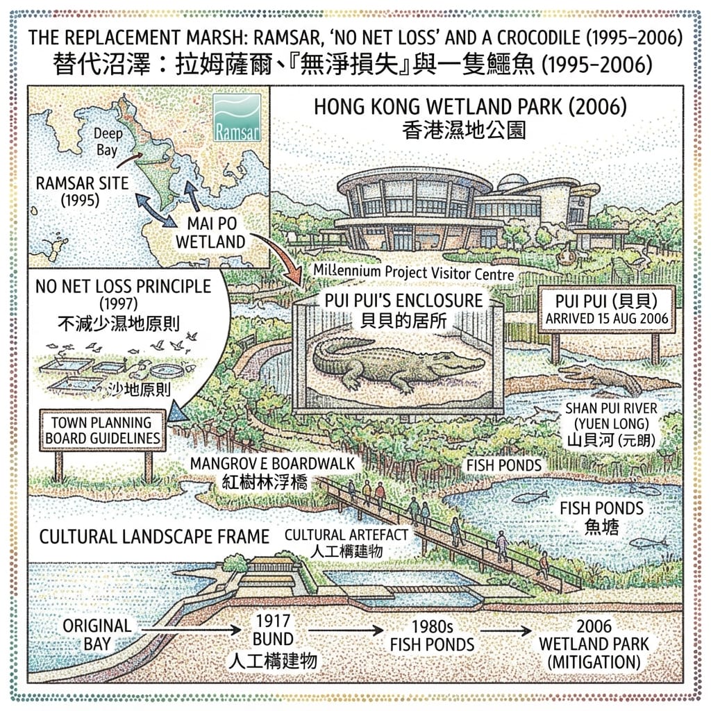
6. The overlooked road
The stretch of Tin Wah Road 天華路 that divides the town into north and south is nowhere on a tourist map. The Planning Department’s own account says that development was first concentrated on the 169 hectares to the south and that the land to the north was kept in reserve until 1994, when it was designated for housing. The road runs roughly along the line the 1982 contract drew. Its exact alignment needs to be checked against the maps annexed to the Legislative Council papers. Standing on it, you see two sets of housing blocks. One lies inside the contract and one outside.
What the place shows now
What survives is the pagoda, the Tang halls of the Ping Shan Heritage Trail, the wetland park, and the more than fifteen thousand flats of Kingswood Villas. What is gone is the village on the bund, the granary and the school, the hundreds of pond-keeping households, and a market that was never built. The place now holds about 280,000 people. What the visitor sees is a new town, an old tower and a nature reserve, none of them far from the others. What is not visible is what connects them: a lease of 1916, a trust of 1980, an agreement of 1982, a clause that stayed until 2002, a conservation rule from 1995. After a walk along Tin Wah Road it is hard to take it for an ordinary road.
Anchor
The enclosure that holds Pui Pui was built for the size she would reach. The park left room for what she had not yet become.
The Chinese character wai, 圍, enclosure, has been used here many times: a bund, a village, a pond, a pen.
Accessing the Physical Node
- Tsui Sing Lau Pagoda: Tuen Ma line to Tin Shui Wai station, exit E3, about two minutes on foot, on the Ping Shan Heritage Trail. Check opening arrangements with the Antiquities and Monuments Office before you go.
- Hong Kong Wetland Park: from Tin Shui Wai station take Light Rail route 705 or 706 to Wetland Park stop. Fees and opening days change; check the park’s website.
- Tin Wah Road and Area 33: both on the Light Rail Tin Shui Wai loop. Check current route maps.
💡 Q&A
Q1 | What is the historical origin of the name Tin Shui Wai and the Zhao family's development project? (Taishan Luen Tak Company and Ha Tsuen Bay Land Records)
A:Historical records indicate that before the twentieth century, modern Tin Shui Wai was a tidal mudflat known as Ha Tsuen Bay, which became Crown land because local Ping Shan Tang clansmen failed to declare title during early colonial land surveys. In 1916, a Taishan-born Zhao family formed the Luen Tak Company and leased approximately 490 hectares, building a 150-metre bund in 1917 to convert the bay into agricultural land. Regarding the name 'Tin Shui Wai', a tradition related by Heung Yee Kuk chairman Lau Wong-fat attributes it to the Zhao ancestral seat of Tianshui, Gansu, in honor of the Song dynasty founder; however, this remains an oral tradition rather than an official primary record, leaving its precise origin uncertain.
Q2 | What is the historical reality behind Tsui Sing Lau Pagoda and the geographical transformation of the Deep Bay estuary? (Ming Dynasty Fung Shui Tower vs. Modern Land Reclamation)
A:According to Ping Shan Tang genealogies, the hexagonal, three-storey Tsui Sing Lau Pagoda was built by seventh-generation ancestor Tang Yin-tung during the Hong Wu reign of the Ming dynasty. Traditional local belief holds that it originally stood at the Deep Bay river mouth to ward off northern ill-fortune, prevent floods, and attract literary success. Historical geography confirms that the area was indeed an open bay until the 1917 bund construction, after which subsequent reclamation shifted the coastline. Today, the pagoda stands surrounded by modern rail lines and housing estates, marking a century-long physical transformation from a water-adjacent geomantic landmark to an inland urban relic.
Q3 | How did Tin Shui Wai transition from an agricultural and fish-farming settlement into a modern new town? (From Mudflat Fish Ponds to Cheung Kong Holdings Development and the Wetland Park)
A:Following post-war transformations from salt-water rice to freshwater fish ponds, Tin Shui Wai became a major local fish-farming hub supporting settlements like Luen Tak Lei throughout the 1970s and 1980s. In 1982, Cheung Kong Holdings acquired most of the agricultural land, paving the way for a 1990s government agreement that cleared the fish ponds to construct high-density public and private housing estates. To balance rapid urbanization with ecological preservation, the Hong Kong government established the Hong Kong Wetland Park in the northern sector, preserving the environmental memory of a landscape that evolved from a tidal bay into a major urban community.
Want to follow the historical routes I’ve selected right from your phone as you walk? Click to join the exclusive Google map of historical tours titled "Historical Travel Stories"—import it to Google Maps on your phone with a single tap and let it guide you as you visit each historical site in person.

📖Reference and Further reading📖
First layer – Main sources of literature and institutions:
- [ExCo-1980] Executive Council memorandum XCC(80)67, “Proposed Development of DD 126 Lot 665, Tin Shui Wai”, 20 May 1980 (scan header misreads 1930), FCO 40 files via HistSyn Hong Kong in Texts: https://hkintexts.histsyn.com/page/1302213
- [Letter-1980] Woo, Kwan, Lee & Lo (solicitors), letter of 7 January 1980, Annex B: https://hkintexts.histsyn.com/page/1302232
- [Wilson-1980] D. Wilson (Political Adviser), letter of 29 September 1980, “Tin Shui Wai”: https://hkintexts.histsyn.com/page/1290453
- [Mightycity-1981] Mightycity Company Ltd, Tin Shui Wai New Town Development Proposal, aide-mémoire (FCO 40/1289): https://hkintexts.histsyn.com/page/1302255
- [ExCo-1981] Executive Council memorandum XCC(81)76, 7 July 1981: https://hkintexts.histsyn.com/page/1302097
- [FCO-1991] FCO 40/2960, “Hong Kong: politically sensitive issues, 1991”, Tin Shui Wai entries: page 17; 1982 agreement and 1990 hearing; expected first residents
- [HKAR-1993] Hong Kong annual report, “Land, Public Works and Utilities” (edition to be confirmed): https://hkintexts.histsyn.com/page/1733751
- [LCQ-2011] Development Bureau, “LCQ1: Tin Shui Wai development”, reply by the Secretary for Development, 16 November 2011: https://www.devb.gov.hk/en/sdev/press/index_id_6875.html
- [PlanD] Planning Department, Tin Shui Wai New Town pamphlet: English PDF; Chinese PDF
- [CEDD] Civil Engineering and Development Department, Tin Shui Wai New Town: https://cedd.gov.hk/eng/about-us/achievements/land/regional-development/w2-tin-shui-wai-new-town/index.html
- [LegCo-2000] LegCo Economic Services Panel paper, “Tin Shui Wai International Wetland Park” (2000): https://www.legco.gov.hk/yr00-01/chinese/panels/es/papers/a197c01.pdf
- [AFCD-WP] Hong Kong Wetland Park, About Us: https://www.wetlandpark.gov.hk/en/aboutus; Pui Pui’s Home: https://wetlandpark.gov.hk/en/exhibition/reserve-puipui
- [LegCo-Welfare] LegCo Welfare Services Panel: Review Panel implementation report, 2005; Provision of welfare services for high-risk families, 30 October 2007
- [GovHK-2007] news.gov.hk, “3 dead in Tin Shui Wai tragedy”, 14 October 2007: https://news.gov.hk/isd/ebulletin/en/category/lawandorder/071014/html/071014en08002.htm
- [GovHK-2004] news.gov.hk, “Yuen Long crocodile named Pui Pui”, 12 August 2004: https://www.news.gov.hk/isd/ebulletin/en/category/environment/040812/print/040812en04002.htm
- [GovHK-2006] news.gov.hk, Pui Pui moves to the Wetland Park: https://www.news.gov.hk/isd/ebulletin/en/hkforkids/default/060829/html/060829en50002.htm
- [Chiculture] Hong Kong Chinese culture portal, “Villagers in the New Territories resisted the British takeover” (1899): https://chiculture.org.hk/en/node/2076
- [AMO-PolyU] Tsui Sing Lau Pagoda, quoting the Antiquities and Monuments Office, PolyU digital collection: https://dc.lib.polyu.edu.hk/pwork/xg94ht07v
The second layer – secondary academic materials:
- R21. Chan, "Challenges in Slope Engineering in Hong Kong" (GEO technical paper, 2007)
- R22. Sino-French Trade at Canton, 1698–1842 (Hong Kong University Press, preview)
- R23. D. Petley, "New, remarkable animation video of the Po Shan Road landslide" (AGU Landslide Blog)
Third layer – Supplementary information:
- [Yip] Maurice Yip, “New Town Planning as Diplomatic Planning: Scalar Politics, British–Chinese Relations, and Hong Kong”, Journal of Urban History (author’s manuscript): https://serval.unil.ch/resource/serval:BIB_C748EBBB2471.P001/REF; published version DOI: 10.1177/0096144220948813
- [Tang-WS] Tang Wing-shing 鄧永成, 〈天水圍:怎一個「虧」字了得?〉, HKBU Centre for China Urban and Regional Studies, Occasional Paper 82 (abstract): https://curs.hkbu.edu.hk/content/dam/curs-assets/document/research/publications/occasional-papers-2010/Abstract%2082.pdf
- [Pryor] Matthew Pryor, “The Meaning of Wetlands: Stories from the Hong Kong Wetland Park”, HKU conference abstract, 2020: https://hub.hku.hk/handle/10722/309962
- Cited by Yip or the oral-history site and not consulted directly (no link): Armando M. da Silva, Native Management of Coastal Wetlands in Hong Kong: A Case Study of Wetland Change at Tin Shui Wai Agricultural Lot (University of Hawaii, 1977); Patrick Hase, The Six-Day War of 1899 (HKU Press, 2008); Sidney C. H. Cheung, “The Politics of Wetlandscape” (2011); Xuexian Wu, Red China Resources Company (2010); Pang Ka-lam and Yeung Ha-chi, “When Tin Shui Wai Met Hong Kong’s Future”, City Magazine (September 2017).
Priority archive visits before drafting
- Hong Kong Observatory Meteorological Results for 1966 and 1972.
- The 1972 Commission of Inquiry report.
- Doberck's 1893 Nature note.
- Tai O guild records.
- Van Dyke's The Canton Trade.
 Lawrence
 Lawrence
 Lawrence