Sanchong (三重), New Taipei: Five Histories on the Left Bank of the Tamsui
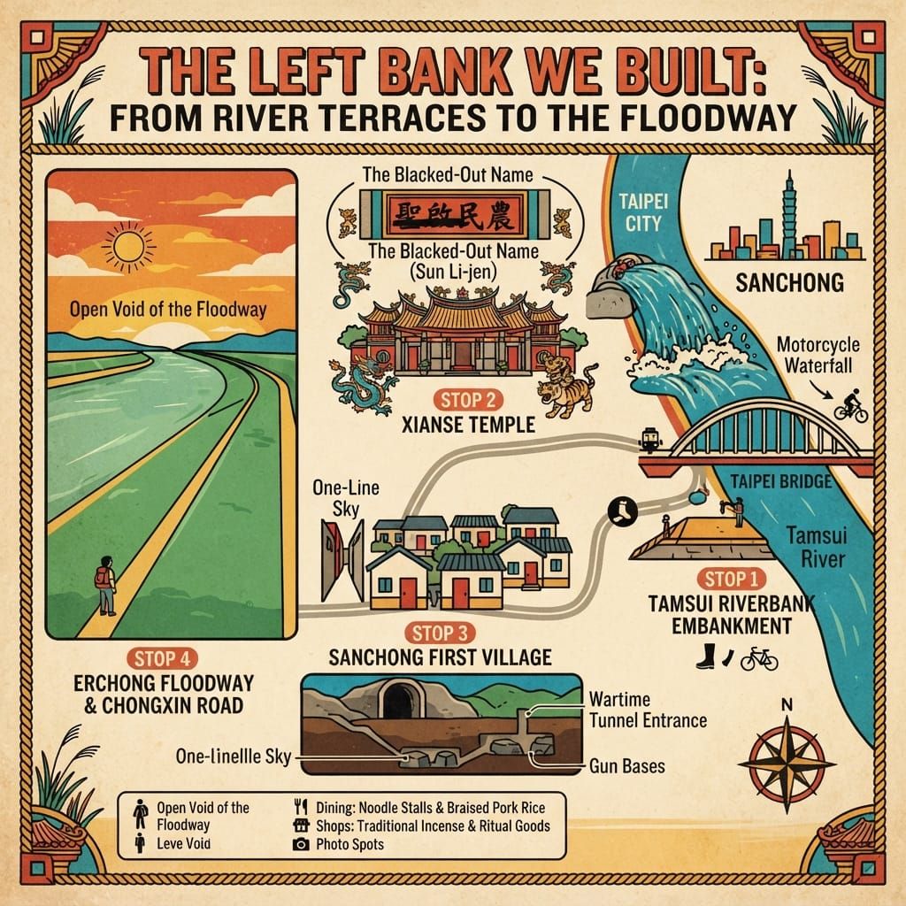
Discover the hidden historical layers of Sanchong on the left bank of the Tamsui River. From its origins as agricultural plains to the bustling worker culture of Taipei Bridge, this guide uncovers five stories that define the spirit of this New Taipei City district.

 Lawrence
This is a historical travel story and walking guide to Sanchong, a densely populated riverside district on the left bank of the Tamsui River in New Taipei City. Through five surprising historical layers, it explores the evolution from early agricultural plains and the iconic Taipei Bridge to industrial memories and river floodways, offering readers a deep look into the everyday lives of the people who shaped this urban gateway.
💡 Únete a una comunidad de viajeros exigentes. Solo tienes que introducir tu correo electrónico para acceder al instante a audioguías e itinerarios de un día, y llevar contigo nuestros exclusivos mapas históricos para recorridos a pie durante tu viaje.
Two stations on the same metro line are named for one bridge. Taipei Bridge stands on the Sanchong side of the Tamsui River; Daqiaotou, “the head of the big bridge”, stands across the water in Taipei. Between the two names lies a river and more than a century of unasked questions. Why is there a bridge here? Who used it first? Who stood at its foot, waiting?
Sanchong covers about sixteen square kilometres and holds roughly 380,000 people, one of the densest districts in Taiwan. It has no hill and no old wall, and outsiders have sometimes dismissed it as a cultural desert. Walk along the river for an afternoon and the dismissal begins to look careless. Each layer of this flat ground keeps returning to one question: what does a place owe to the larger city beside it, and what does the larger city owe back?
1. Three Plains
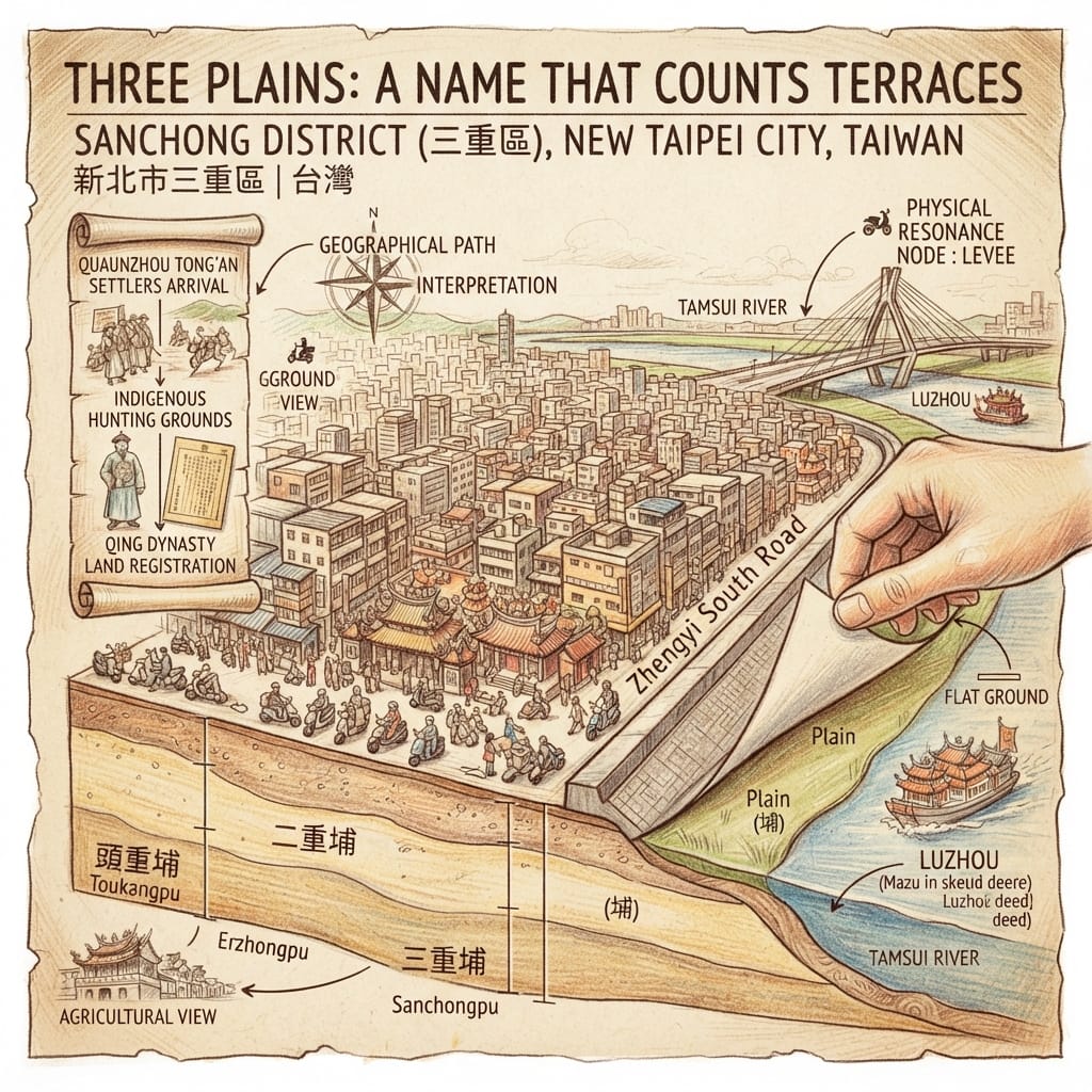
The old name of the district is Sanchongpu (三重埔), pronounced in Hokkien Sam-tiông-po͘, and it reads roughly as “the third plain”. A pu is a river terrace built from silt. Local historians describe three of them in sequence: Touchongpu, near today’s IKEA and Huacheng Road, now mostly inside Xinzhuang; Erchongpu, around Tangcheng; and Sanchongpu, the busiest and best known, which finally lent its name to the whole district. One commentator reads the order as a migration route: settlers gathered first at Xinzhuang and moved downstream when its river port silted up. It is a plausible reading and a popular one, but nobody has produced a chronology to prove it.
Before the Han names came, this land belonged to others. The people usually associated with it are the Pusenwan (武朥灣社), part of the northern Taiwan Austronesian world that scholars conventionally call Ketagalan. The historian Wu Jirui (吳基瑞) drew their territory to include northern Banqiao, Xinzhuang, Sanchong, Luzhou, Wugu and Taishan. Later researchers challenged parts of that map, and some doubt that “Ketagalan” was ever a name the people used for themselves. None of this is settled.
The Secret Map In Sanchong S Name
Luzhou, next door, kept a clearer paper trail. In 1743 a Pusenwan headman named Junxiao and others gave the river islet of Zhongzhouzi, also called Heshang Zhou, to the Guandu Mazu temple. By 1757 Luzhou was an official estate on the Qing tax rolls. In fourteen years a gift became an entry in a register. That is Luzhou, not Sanchong, but the same current carried the terraces of Sanchong.
About belief, the records say very little. No Pusenwan sacred site, alignment or ritual ground in Sanchong survives in any source I could find, and it would be wrong to supply one. What the name does preserve is a settler’s eye: land counted as a farmer counts, plain by plain, in the order it was taken.
Resonance Node. The embankment near the end of Zhengyi South Road is a suggested place to stand. It is a viewing point, not a historical marker.
Holographic Sensory Cue. There is no hill in Sanchong. The ground is flat because it was built by a river, and the levee rises where the plain ends.
2. The Bridge That Carried a Railway, Then Workers
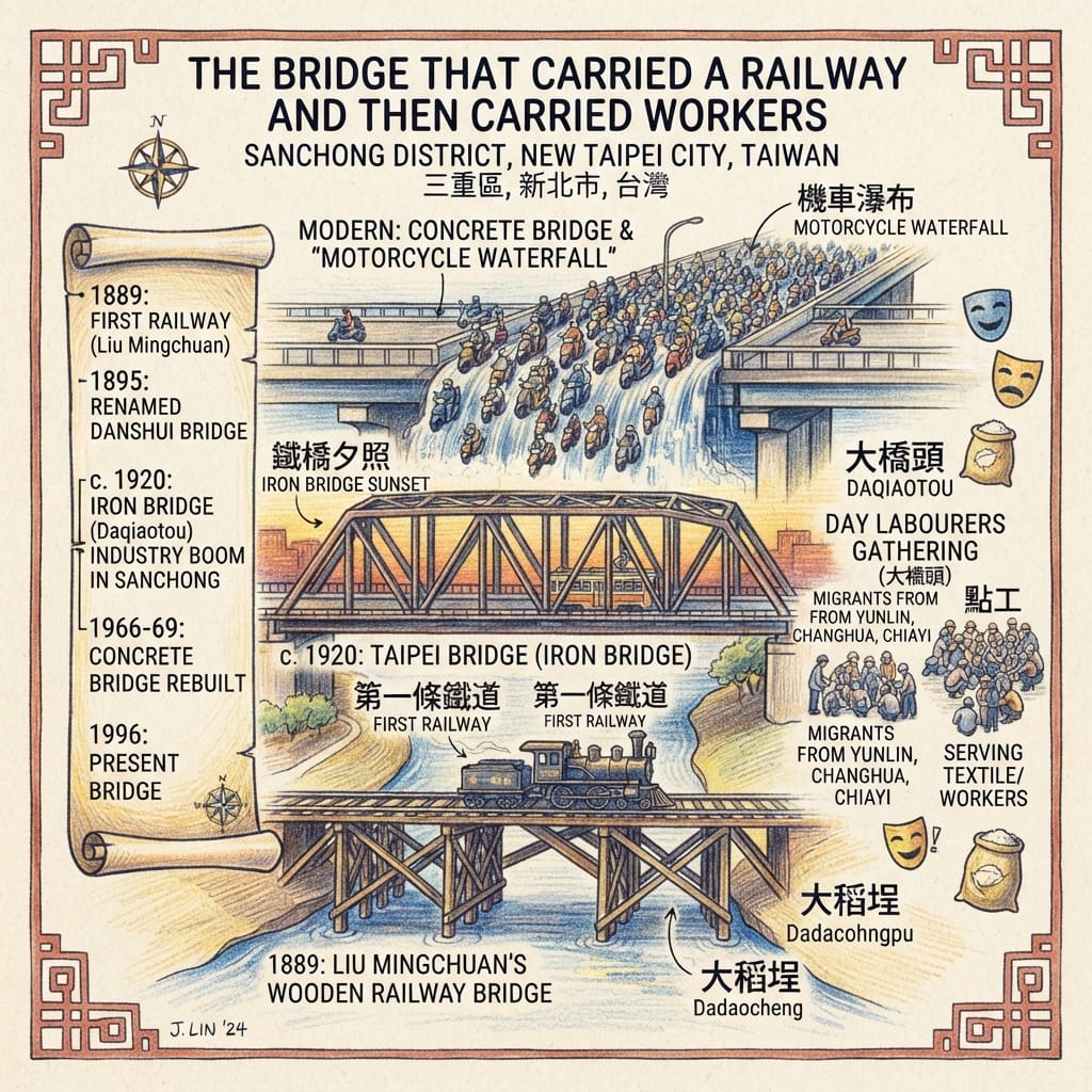
In August 1889 a timber bridge opened between Dadaocheng in Taipei and Sanchongpu, built under Taiwan’s first governor, Liu Mingchuan (劉銘傳). According to a photo-history compiled by the Sanchong district office, the Keelung–Hsinchu line, Taiwan’s first railway, ran over it from 1893. In 1895 the crossing was renamed Danshui Bridge. Around 1920 it was rebuilt in iron and named Taipei Bridge; “Iron Bridge at sunset” became one of Taipei’s scenic views, and the name passed to a ward of Japanese Taipei and a public school. A popular account says the timber was hard to maintain and the railway was later rerouted, so no trains crossed it afterwards. That claim awaits railway-history sources.
The iron bridge mattered more to Sanchong than to the railway. The district office’s history says that once the bridge and better roads were in place, Sanchong shifted from a farming settlement to an industrial one, and its population grew. In the 1960s, under an export-led economy, textile, food, plastics and electronics works clustered along Provincial Highway 1 through Xinzhuang, Sanchong and Banqiao. Of the migrants who moved to the Taipei County area from central and southern Taiwan, those from Yunlin were the most numerous, followed by Changhua and Chiayi.
At the other end of the bridge, others waited. Daqiaotou became a gathering place for day labourers. A man in his eighties who had once worked there told a reporter that hundreds waited each day to be assigned jobs; a 1991 film, Huangpao jiashen, drew on this casual labour market. One citizen-journalism report adds that in the 1960s and 1970s more than twenty theatres stood near the bridge, serving factory workers and migrants. That figure needs corroboration.
The Railway Bridge That Lost Its Trains
The bridge was replaced again and again: demolition of the old one began in 1966, a concrete bridge opened on 15 November 1969 and charged tolls into the early 1990s, and the present bridge opened on 16 July 1996. A structure built to carry a railway lost its railway almost at once and went on carrying people who crossed the river to earn a living.
Resonance Node. Both ends of Taipei Bridge: the Sanchong bridgehead, and the Daqiaotou side where workers once waited.
Holographic Sensory Cue. The dense stream of motorbikes crossing together, which the local press has nicknamed a “motorcycle waterfall”. The sound of trains on the timber bridge is not reliably documented, and I do not reconstruct it.
3. Two Schools of Craftsmen and a Name Left Black
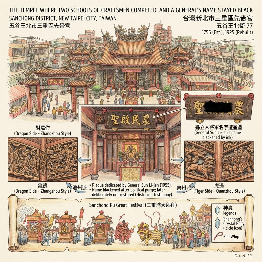
Xianse Temple (先嗇宮) stands at 77 Wuguwang North Street and is usually dated to 1755. Its patron is Shennong, the divine farmer. The name comes from an ancient rite honouring eight agricultural spirits, the first of whom is the discoverer of farming. A student project says the name was fixed in the Japanese period and that the building began as a thatched shrine.
In 1925 the temple was rebuilt by the method called duichang zuo (對場作): the dragon side and the tiger side were given to two rival teams of craftsmen, who competed while keeping matching proportions. The same student project identifies the teams as Zhangzhou-trained and Quanzhou-trained masters; the temple’s own records should confirm this. A Daoguang-era plaque and several steles recording repairs and donations survive inside. On the twenty-sixth day of the fourth lunar month, Shennong’s birthday, the district once held the great Sanchongpu festival, known across the island. Today it is a cultural festival now in its twenty-sixth edition.
The Plaque That Preserved Its Own Censorship
Before the main hall hangs a plaque reading Sheng qi min nong. According to the temple’s chairman, Lee Chien-lung (李乾龍), it carries a dedication from General Sun Li-jen (孫立人). Sun was removed from command and placed under house arrest in 1955 after a subordinate was accused of being a communist agent. He was freed in 1988 and died in 1990; the Control Yuan’s 2014 inquiry, as later reported, called the case a political purge. The temple, the chairman says, blackened Sun’s name and left the plaque on the wall. When Sun’s descendants later asked for the name to be restored, the chairman declined, saying the black ink is itself testimony. This account comes from a piece marked as advertorial and has not been checked against the plaque or a second source.
Of Shennong himself, temple lore says he had a transparent belly through which he could see into the body, and a red whip with which he tested herbs. This is myth, and nothing here depends on it. Belief and history can sit side by side without either replacing the other.
A temple built to ask for harvests has the rivalry of two schools of craftsmen set into its walls, and on one plaque it carries the mark of a political erasure.
Resonance Node. The Sheng qi min nong plaque before the main hall, and the left–right asymmetry of the 1925 building.
Holographic Sensory Cue. One patch of ink darker than the surrounding wood, and the visible difference in carving between the two sides.
4. Guns on a Hill, Families in the Lanes
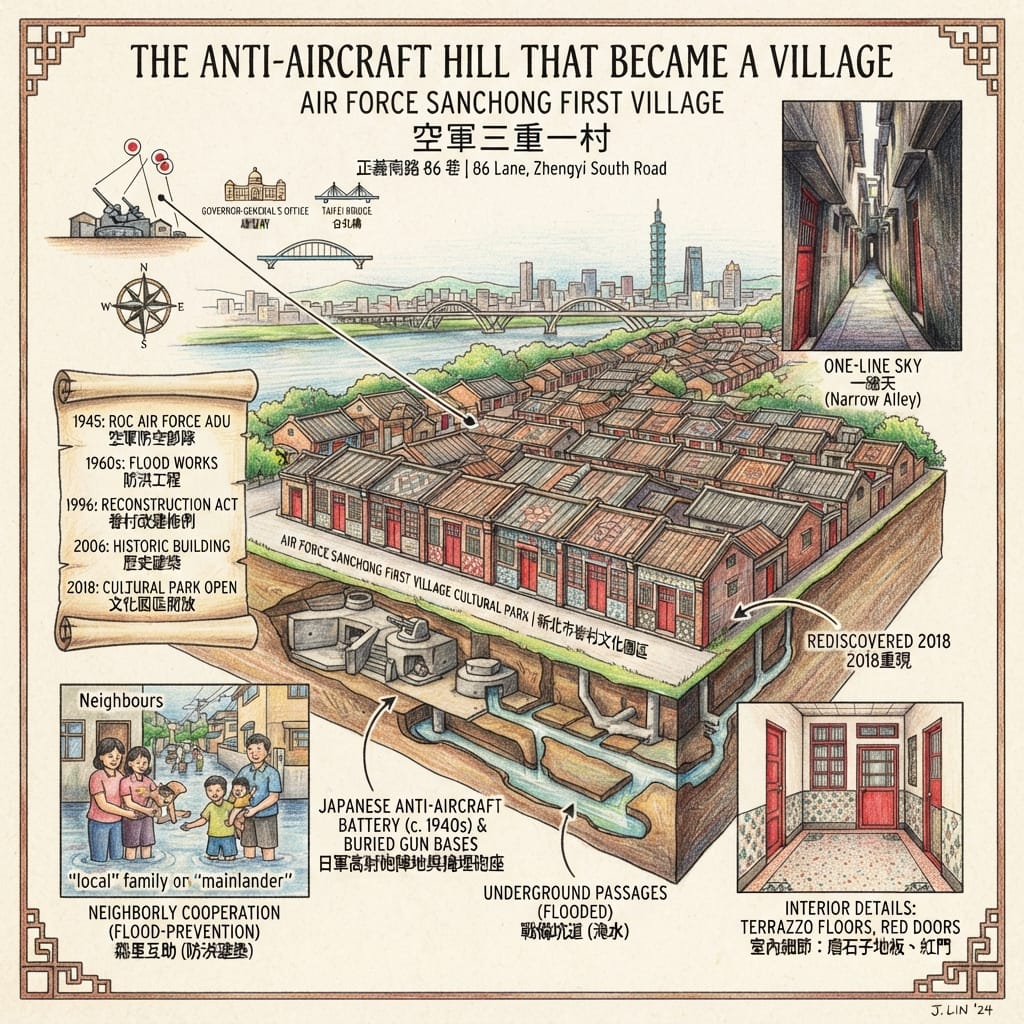
The Air Force Sanchong First Village (空軍三重一村) covers about 1.38 hectares on Zhengyi South Road. It began as a Japanese anti-aircraft battery: the colonial government built six gun positions in this area against Allied raids. One student-media report says they protected the Governor-General’s Office and Taipei Bridge; that pairing comes from this report alone. After the war the ground housed the Republic of China Air Force’s anti-aircraft units and their families. When the village was built, the gun bases were buried. Two of them came back to light only in 2018, during restoration.
Below ground runs a wartime passage with ten entrances, once an ammunition store and shelter. It floods in heavy rain, and children of the village treated it as an adventure ground. Housing was divided into four grades, jia, yi, bing and te, matching military rank, and the outer buildings were shaped as flood-prevention houses because the Tamsui regularly overflowed. Residents extended their houses into front and back yards until the facing rows nearly touched, leaving the narrow lane that locals call “one line of sky”.
The Village Built On Buried Guns
In 1996 a law for rebuilding old military dependents’ villages marked this one for demolition and conversion to a park. Relocation began around 2003. A Sanchong-born architectural professional came home to argue for preservation, noting that outsiders regarded the district as a cultural desert. Over some twelve years of campaigning, residents and the government registered it in 2006 as a historic building, the first dependents’ village to be heritage-listed in New Taipei. It is now the New Taipei City Military Dependents’ Village Cultural Park. A school lecture note reads the flood-house design as a sign of cooperation between “local” and “mainlander” neighbours. That is an interpretation, still to be tested against oral histories.
One regime’s gun position, aimed at the sky over the government quarter across the river, becomes the home of another regime’s air force families, and in peacetime almost disappears under a rebuilding law, until the people of a district said to have no culture insist on keeping it.
Resonance Node. The exposed gun-base remains and tunnel entrances inside the park, and the “one line of sky” lanes.
Holographic Sensory Cue. Terrazzo floors, patterned tiles, patterned windows and red doors in the preserved houses; after heavy rain, standing water in the tunnel.
5. The Floodway
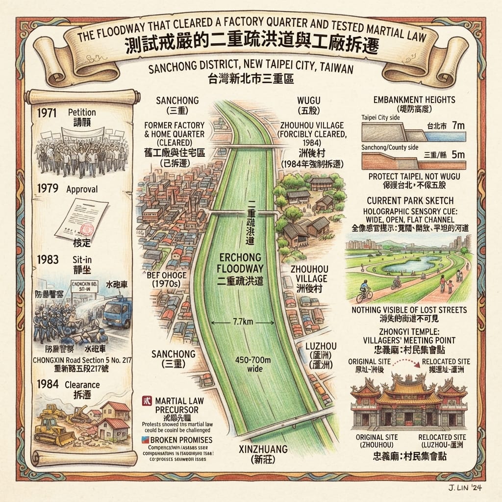
The Erchong Floodway (二重疏洪道) is about 7.7 kilometres long and between 450 and 700 metres wide, covering roughly 424 hectares across Sanchong, Xinzhuang, Luzhou and Wugu.
In June 1971 more than 1,400 households and factories in the Erchong area of Sanchong petitioned the provincial assembly to cancel the plan. In January 1979 the Executive Yuan approved a Taipei flood-control scheme that included the floodway. The land had been designated a first-class flood-control zone, with building banned for seventeen years, and compensation was calculated on old, low official land values. Many who left could not afford to buy again.
On 4 January 1983 several hundred residents sat down outside 217 Chongxin Road, Section 5, in Sanchong, and the north–south highway stopped for about nine hours; the press reported riot police and fire hoses. Four days later the provincial government announced five relief measures, including a bonus of NT$800,000 per hectare and NT$20,000 for each legally employed factory worker. Work formally began on 18 January.
The Floodway That Sparked A Rebellion
In 1984 the works reached Zhouhou Village (洲後村) in Wugu: 316 households. Villagers petitioned the Legislative and Executive Yuan on 6 July, won three postponements, and on 26 July met in front of their village temple, Zhongyi Temple, to form a relocation committee. They were cleared by force on 16 August. The authorities said more than 5,000 houses and factories inside the floodway had already been demolished and a few hundred remained, and that the channel would protect more than three million people in the basin. A 1977 newspaper report cited by the historians noted that Taipei’s embankment on the river was to stand about seven metres high, while the county’s, on the opposite bank, was planned at about five.
The historians Chen Chun-kai (陳君愷) and Lai Chien-huan (賴建寰) read these events in a particular way: because the dispute was over property and not over party politics, the authorities did not treat it as martial law normally required, and with the capital just across the river and the press attentive, the protests showed that the ban on assembly could be challenged. The opposition magazines that reported the clearance wrote with a purpose. Their accounts are testimony, not neutral records.
Both things are true. The channel protects a very large population, and a promise to build new homes first and demolish afterwards was, to the people sent away, a promise that did not hold. Zhouhou belonged to Wugu, not Sanchong, but the floodway carries the name of Sanchong’s Erchong, and Sanchong’s own factories and families stood inside the cleared zone.
Resonance Node. The Chongxin Road corridor and the floodway levee.
Holographic Sensory Cue. A wide, flat green channel between levees, with cycle paths and wetland park today. Of the lost streets nothing can be seen, and that absence is the cue.
The Left Bank
Put the five stories side by side and a pattern appears. Sanchong lies on the left bank of the Tamsui, looking downstream, and again and again its land and people have been arranged around the needs of the city on the right bank: settlers moving down the river, a bridge built to reach Taipei, guns placed to protect it, a channel opened so that it would stay dry. And each time, the people here answered in their own way: a temple, a village saved, a sit-in. This is an interpretation, not evidence of a plan. The bridge, the guns and the channel each had reasons that stand on their own; the question is who paid.
What remains today: Xianse Temple and its festival, the Air Force village, the name Taipei Bridge, the levees and the floodway. What has gone: the timber bridge and its trains, the houses, factories and Zhouhou Village inside the floodway, most of the Japanese gun bases below ground, the theatre crowds beside the bridge. What has changed: the floodway is a park and cycle path; the village that was to be demolished is a cultural park.
Coda
In Xianse Temple, on a plaque before the main hall, one patch of ink is darker than the rest. There was a name there. Nobody wiped it clean, and nobody painted it back.
Accessing the Physical Node
- Taipei Bridge and Daqiaotou: ride the Zhonghe–Xinlu metro line to Taipei Bridge Station (Sanchong side) or Daqiaotou Station (Datong side). The bridge can be crossed on foot.
- Air Force Sanchong First Village (New Taipei City Military Dependents’ Village Cultural Park): 86 Lane, Zhengyi South Road. About 13 minutes’ walk from Taipei Bridge Station; buses 211, 221, 261, 306 and 704 stop at Zhengyi South Road end, about a minute away. Tourism reports say entry is free and opening hours have been 10:00–18:00; confirm with the official source before you go.
- Xianse Temple: 77 Wuguwang North Street, a public temple. The New Taipei Metropolitan Park lies nearby, and the Lantern Festival lights link the two.
- Erchong Floodway: walk or cycle along the levee and riverside parks to see the scale of the channel.
Opening hours and transport routes can change; check current official information.
💡 Q&A (Frequently Asked Questions)
Q1: What is the origin and historical meaning of the name "Sanchong" (Sanchongpu)?
A1: The name "Sanchong" originates from "Sanchongpu" (三重埔). In Taiwanese Han settlement terminology, "Pu" (埔) refers to flat alluvial plains created by river deposits. As early Han settlers moved inland along the Tamsui River Basin to clear land for agriculture, they named areas sequentially based on the order of development: Touchongpu (1st stage, present-day Dingkan area), Erchongpu (2nd stage), and Sanchongpu (3rd stage). Thus, Sanchong represents the third major plain cleared for farming.
Q2: Who were the indigenous inhabitants of Sanchong prior to Han Chinese settlement?
A2: Before Han Chinese immigration in the 17th and 18th centuries, the left bank of the Tamsui River—including modern-day Sanchong, Luzhou, Xinzhuang, and Panchiao—was the ancestral territory of the Pusanwan (武朥灣社) settlement, belonging to the indigenous Ketagalan people.
Q3: How did the construction of the Taipei Bridge impact Sanchong's development?
A3: Originally built as a wooden bridge under Qing Dynasty Governor Liu Mingchuan in 1889 and later rebuilt as an iron truss bridge during Japanese rule, the Taipei Bridge connected Sanchong with Dadaocheng (Taipei City). It eliminated Sanchong's geographical isolation, transforming it from a rural agricultural village into a vital transportation hub and an industrial springboard for migrants entering Taipei.
Q4: How did Sanchong evolve into a light-industrial and migrant worker hub during the 1960s?
A4: With the expansion of Provincial Highway 1 and the connectivity of Taipei Bridge during Taiwan's post-WWII economic boom, Sanchong became a dense ecosystem for light manufacturing—such as textiles, plastics, machinery parts, and food processing. This industrial boom attracted thousands of domestic migrants from central and southern Taiwan (e.g., Yunlin, Chiayi, Changhua), shaping Sanchong's distinct working-class identity and rich street food culture.
Q5: Why was the Erchong Floodway constructed, and what function does it serve today?
A5: The Erchong Floodway was built in the 1980s as part of a major government flood mitigation initiative to protect the low-lying Taipei Basin from Tamsui River overflows. Today, in addition to its crucial water-management role, the floodway features vast open green space, including the Metropolitan Park, providing recreational areas for exercise, public events, and nature preservation.
¿Quieres seguir las rutas históricas que he seleccionado directamente desde tu teléfono mientras caminas? Haz clic para unirte al mapa exclusivo de recorridos históricos en Google titulado "Historical Travel Stories": impórtalo a Google Maps en tu teléfono con un solo toque y deja que te guíe mientras visitas cada lugar histórico en persona.

📖Referencias y lecturas adicionales📖
Fuentes primarias (archivos y materiales históricos oficiales)
- 第一層・官方/制度性原始來源
- [R1] 杉並区: 区の沿革 (Suginami Ward history; 1889 villages, 1932 incorporation)
- [R3] 杉並区: 京王線沿線まちづくりニュース 第3号 (aishuku system, honjin sites, 高井戸丸太, Keiō 1913)
- [R4] 杉並区: 甲州道中一里塚跡 (marker text)
- [R5] 新宿区: 新宿区について (Naitō-Shinjuku founding)
- [R9] 杉並区: 宗源寺 (marker text)
- [R10] 杉並区: 吉祥院 (marker text)
- [R11a] Edo-Tokyo Museum Digital Archives: 修験宗廃止につき太政官布達 (1872)
- [R14] 東京都都市整備局: 歴史的建造物 (浴風会本館, selection no. 37)
- [R16] 杉並区: 東京ごみ戦争
- [R17] 杉並区: 区の歩み 年表 (1968 expropriation; 1972 Kōtō blockade)
- [R18] 杉並区: 杉並清掃工場 施設案内 (address, hours, 歴史みらい館)
- [R21] 杉並区立郷土博物館: 常設展示室 (高橋松亭《高井戸の夕立》)
- [R25] 杉並区: 指定文化財 有形民俗文化財 (板絵着色西国巡礼図, 長泉寺)
- [R8] Bibliographic records only (not read): 杉並区教育委員会『甲州道中「高井戸宿」』1981, CiNii; 杉並区立郷土博物館『すぎなみの地域史 II 高井戸』2019, NDL
Materiales de nivel 2 (trabajos académicos)
- [R12] 岡本多喜子「関東大震災の義捐金処分と浴風会の創設」(Meiji Gakuin; funding, site, staff, wartime)
- [R13] 文京学院大学紀要 (浴風園の沿革; 1925 site decision)
- [R11b] 林淳「明治五年修験宗廃止令をめぐる一考察」(2002), catalogue record (not read); 群馬県: 1872 修験道廃止令の説明
- [R15] Kotobank: 志賀重昂 (biography)
- [R17b] 大阪大学リポジトリ: 志賀重昂論 (death date 6 April 1927)
- [R18b] 国立国会図書館 Kaleido: 志賀重昂 (death March 1927)
- [R6] 財務省「ファイナンス」2024年1月号: 新宿区 (opening 1699, abolished 1718, revived 1772)
- [R7] 幻冬舎GOLD ONLINE: 内藤新宿 (1698 petition); nippon.com: 内藤新宿と四谷大木戸
- [R22] すぎなみ学倶楽部: 地名資料 (小島郷 speculation)
Información de nivel 3 (Información complementaria)
 Lawrence
 Lawrence
 Lawrence
 Lawrence