The City Banqiao Keeps Building Over Itself
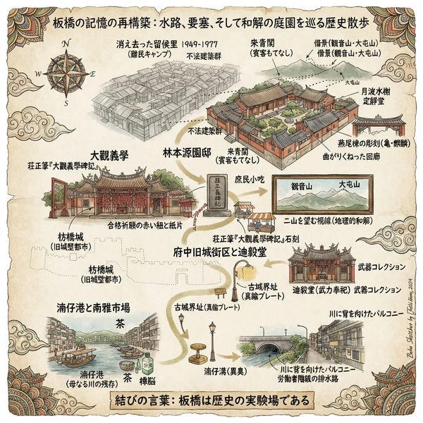
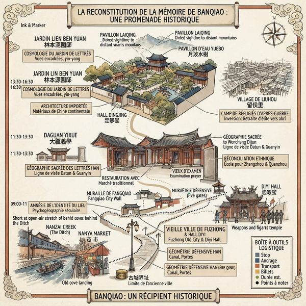
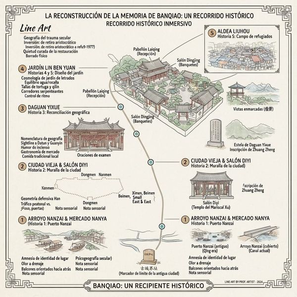
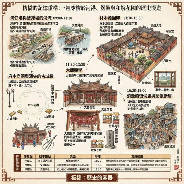
Everyone visits Banqiao for the Lin Family Garden. Almost no one notices the vanished port beneath the pavement, the ghost of a private city wall in the street names, or the twenty-eight years the garden itself spent as a refugee slum. Five buried histories, and the pattern connecting all of them.

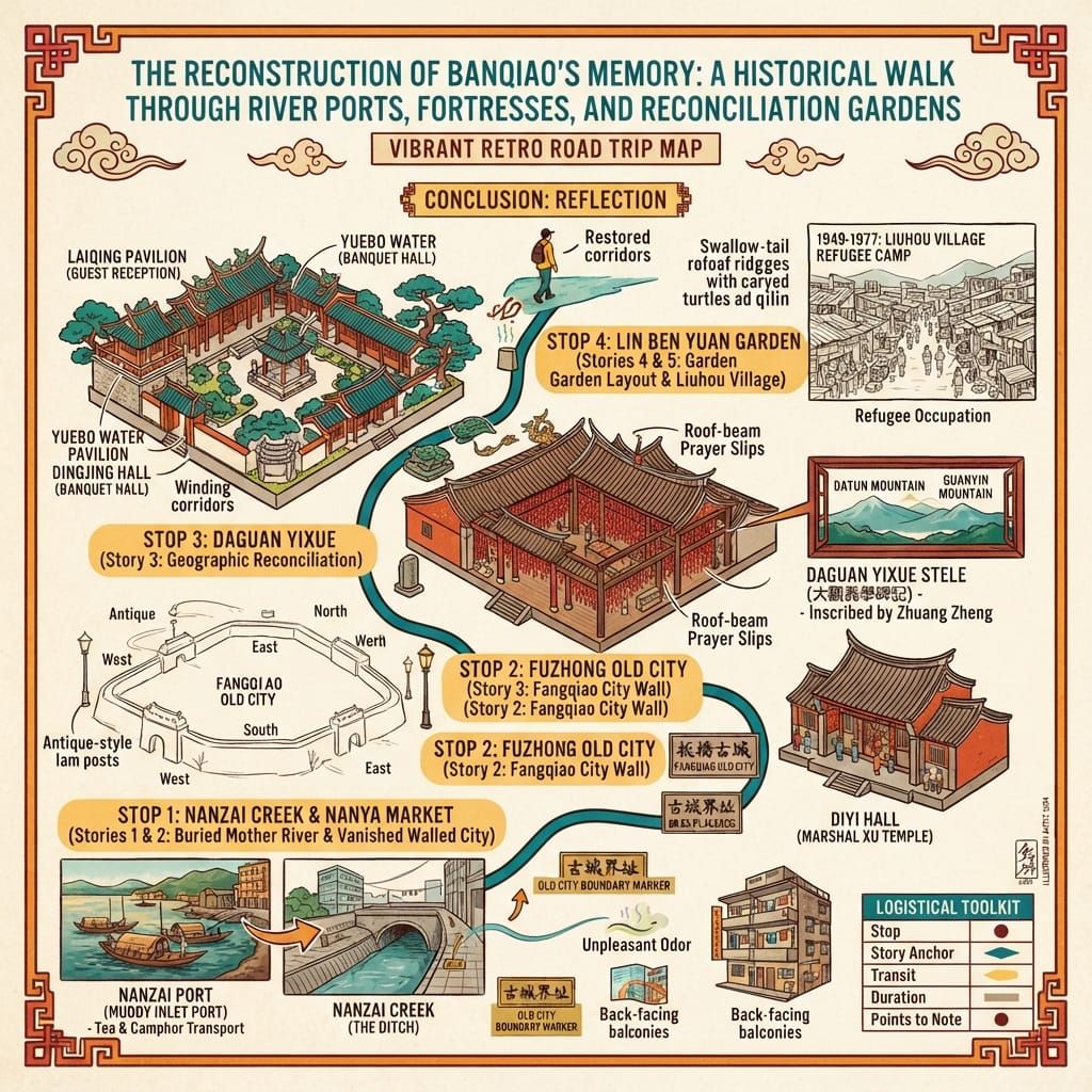
💡 Join a community of discerning travelers. Simply enter your email to instantly unlock audio guides and one-day itineraries, and carry our exclusive historical walking maps with you on your journey.
 Lawrence
A garden, a renamed river, and five histories the guidebooks skip — Banqiao is proof that the real architecture of a place isn't brick or stone, but the decision, made again and again, about what gets remembered and what gets quietly paved over.
Most visitors to Banqiao come for one thing: the Lin Family Garden, a walled compound of pavilions, ponds, and moon gates that ranks among the best-preserved private gardens of the Qing dynasty anywhere in the Chinese-speaking world. They photograph the carved eaves of the Guest Pavilion, walk the covered corridors, and leave an hour later, satisfied.
Almost none of them notice the small brass-toned plaques set into the pavement a few blocks away, stamped with four characters: old city boundary. There is no wall there anymore. There hasn't been one in over a century. But for fifty years, Banqiao was a walled town — one of the very few in Qing-era Taiwan built not by the state, but by a single merchant family, for reasons that had everything to do with survival and almost nothing to do with the garden tourists now queue to see.
Banqiao, in other words, is not the story of a garden. It's a case study in how a place absorbs violence, resolves it through the deliberate use of geography, and then — with remarkable consistency — builds something beautiful directly on top of the wound and calls that beauty the whole story. This is a cluster node: not one single overwhelming site, but a tight constellation of five interlocking histories, each a local echo of the larger, unresolved drama of the Taipei Basin's settlement.
The Weight of the Place
Banqiao's name comes from a plank bridge nobody alive remembers crossing, laid over a canal that no longer exists, to solve a mud problem nobody today would think twice about. And yet that unremarkable act of infrastructure ended up naming an entire district — while the river it crossed, the indigenous village that stood nearby, and the fortress wall that once encircled the town it served have all, in their different ways, gone quiet.
This is what makes Banqiao worth stopping for. Not the garden alone, but the pattern underneath it: five separate ruptures — a vanished people, an ethnic war, a diplomatic marriage, forty years of obsessive garden-building, and a refugee occupation — each one resolved by turning geography into an instrument, and each one, once resolved, carefully tidied out of view.
I. The River That Got Demoted to a Ditch
The Human History
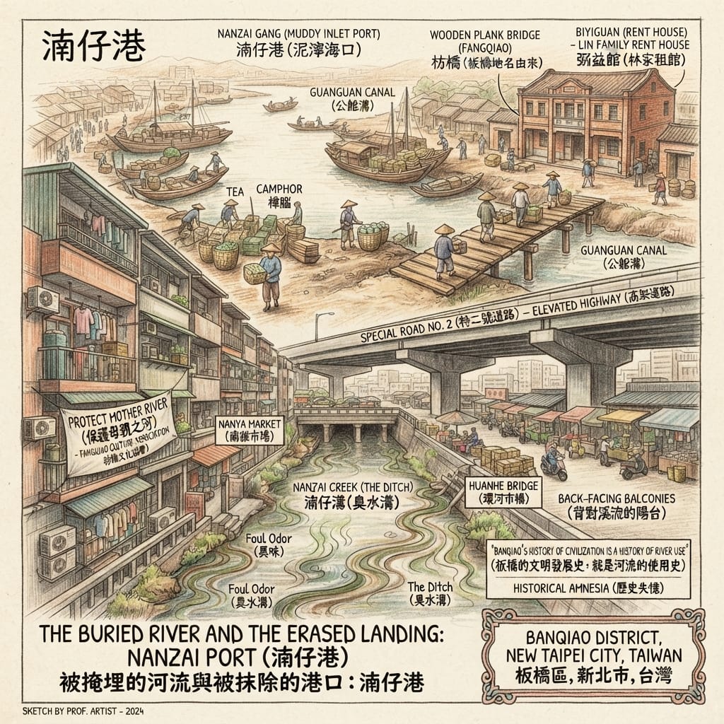
Before Han settlers arrived, this basin belonged to Pattsiran, a Ketagalan village first recorded by the Qing travel-writer Yu Yonghe in 1697, under the transliterated name Baijie She — a name that survives today only as a fossil in old gazetteers, its own meaning to the people who lived here lost entirely. By the eighteenth century, Han settlers had built their economy on the river system instead: tea and camphor came down from the hills and were loaded at a natural cove they called Nanzai Port — "the muddy inlet," from the Hokkien for marsh. A plank bridge was thrown across the adjoining canal so porters could carry goods into town, and that bridge — Banqiao — eventually lent its name to the whole district.
Through the twentieth century, as rail and road replaced river trade, the port silted up, was reclassified from "port" to "ditch," and was slowly buried under roads, a market, and a parking lot. By the 2000s, only one short open stretch remained, and it was nearly buried too, under an elevated highway, before a local heritage group fought the plan to a standstill.
The River Erased By A Single Word
Reading the Site
There is no surviving record detailed enough to reconstruct how Pattsiran itself understood this land spiritually — and manufacturing one here would be exactly the kind of borrowed mysticism this inquiry is trying to avoid. What actually happened to this river is better read through a secular lens: memory geography, the study of how a place's meaning survives — or doesn't — in the language a community uses for it.
Because that's precisely what happened here. Local historians now call the buried channel Banqiao's "mother river," language borrowed from kinship rather than religion, but doing exactly the work a sacred river would do elsewhere: anchoring a community's sense of where it began. And the erasure that nearly took it happened first in language, not concrete — a working port quietly renamed a ditch, and then a "stinking ditch," until burying what was left of it seemed like no loss at all.
Holographic Sensory Cue: Stand at the one open stretch of water behind Nanya Market and the smell is not pleasant — this isn't a restored heritage feature, it's a working drainage channel that happens to be the ghost of a trade route. Every apartment balcony along the bank was built facing away from the water, toward the street — an entire generation's architecture of turning its back.
II. The Private Fortress Nobody Asked Permission to Build
The Human History
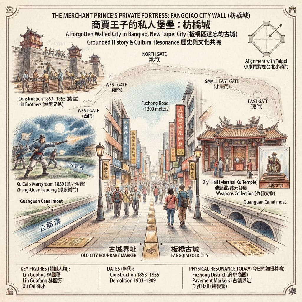
Qing-era Taiwan had weak state policing and a long, bloody habit of zhang-quan xiedou — organized feuding between settlers from Zhangzhou and settlers from Quanzhou, two neighboring prefectures in Fujian, fighting over land and water with something close to open warfare. The Lin family, Zhangzhou by origin and by this point the wealthiest lineage on the island, had already been driven to build one defensive wall elsewhere before relocating to Banqiao and, in 1853, quietly building another — this time an entire fortified town, without asking Qing authorities for permission.
Fangqiao City, completed in 1855, stood five meters high, ran roughly 1,300 meters around, and had five gates, each staffed around the clock by hired militia. It predates Taipei's own official walled city by twenty-eight years. In 1859, during a night raid across the river, the Lin family's militia captain, Xu Cai, was spotted by moonlight and shot dead along with twelve of his men.
The Merchant S Private Fortress
Reading the Site
This is where the region's own folk-religious vocabulary takes over, and it is worth taking seriously on its own terms rather than filed away as superstition. In 1873, the Lin family built a temple — Diyi Hall, still active today — to formally deify Xu Cai and his twelve fallen companions as protective spirits. This is a well-documented pattern in Hoklo folk religion: a community that has absorbed a violent, unresolved death converts that death into an object of permanent, structured worship, rather than simply grieving and moving on. The dead become guardians. The wound becomes a shrine.
The wall's own layout follows the same logic in miniature — a canal doing duty as a moat, garrison towers at each gate, defensive geometry as ordinary as any fortress anywhere. But one detail stands out: the wall's Small East Gate was oriented to face, and eventually did face, Taipei's own Small South Gate once it was finally built almost three decades later — less an astronomical alignment than a political one, a private city's front door already turned toward the official authority that hadn't yet arrived.
Resonance Node: Diyi Hall sits in a quiet lane off Guanqian West Road, easy to miss, its incense never quite stopping. Unlike the crowded garden a short walk away, almost no visitor comes here — which is exactly why it still holds the raw, undiluted weight of grief the garden has long since had restored out of it.
III. A School Named After a View
The Human History
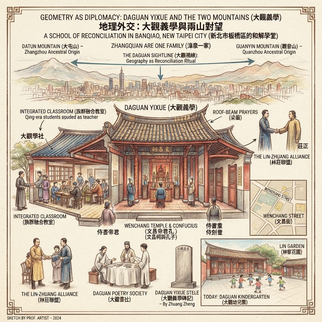
A wall can hold off violence. It cannot end it. By the 1860s, the Lin family understood that peace would need a different kind of architecture. Lin Weirang arranged his sister's marriage to Zhuang Zheng, a Quanzhou-born scholar from Wanhua, and in 1863 the two families jointly founded a school that deliberately seated Zhangzhou and Quanzhou children in the same classroom. In 1873 it was expanded and renamed Daguan Yixue — "the School of the Great View" — and the two families began hosting a joint poetry salon for scholars of both origins. Within a generation, the district's rate of examination success was second in the region only to Wanhua itself.
Reading the Site
The name is not decoration — it's the entire argument, made in four characters. From the school's site, both Datun Mountain to the northeast and Guanyin Mountain to the northwest are visible at once, facing each other across the basin. Zhangzhou settler communities had historically clustered near Datun's foothills; Quanzhou communities near Guanyin's. By naming the reconciliation school for the one place where both peaks could be seen together, the Lin and Zhuang families turned a literal sightline into a political statement: Zhangzhou and Quanzhou are one family, written not in a treaty but in the geography itself, so that anyone standing on the site could see the peace with their own eyes.
How Geometry Stopped A Blood Feud
It's worth being precise about what this is and isn't. No compass-based geomantic survey for the site's selection survives in the record, and this account makes no claim to one. What it does document is something arguably more interesting: a self-conscious, textually attested act of landscape diplomacy — geography deployed not to channel unseen forces, but to make a political settlement physically undeniable.
Holographic Sensory Cue: Inside, the roof beams are still layered with paper prayer slips left by students sitting exams — a votive ritual that has run continuously for a century and a half without a single year's interruption, ink and red string accumulating over Qing-dynasty timber.
IV. A Garden Built to Borrow a Mountain
The Human History
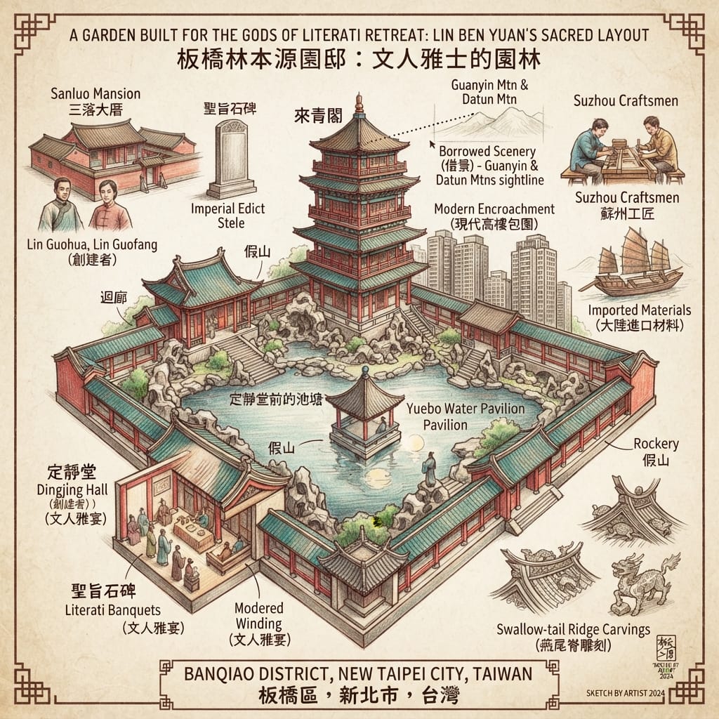
By the 1880s, the Lin family — by then trading under the compound name Lin Ben Yuan — were arguably the wealthiest lineage in Taiwan, holders of salt and land monopolies and financiers of Qing military campaigns. Having already built their fortified mansion inside the town walls, they spent the next forty years and roughly 500,000 taels of silver — more than double the cost of Taipei's official city wall — constructing a full Jiangnan-style literati garden, modeled on Suzhou prototypes and built with materials shipped from the mainland. It was finished in 1893. The following year, the Qing lost the Sino-Japanese War, ceded Taiwan to Japan, and the Lin family fled to Xiamen, never to live here permanently again.
Reading the Site
The garden's tallest structure, the Pavilion of the Arriving Green, is named for exactly what its upper floor was built to do: frame, in a single window, the distant silhouettes of Guanyin and Datun mountains — the same two peaks that give Daguan Yixue its name a few streets away. It was here that the family received its most important guests, meaning the household's single most consequential social ritual took place inside a room engineered specifically to pull a borrowed mountain view into an interior space.
How Chinese Gardens Borrow Mountains
This is the classical Chinese garden technique of jiejing — borrowed scenery — practiced with total fidelity to its Jiangnan source: a moon-viewing pavilion set at the center of the pond, a great hall reserved for family banquets, an entire vocabulary of built form imported wholesale onto land that, a century earlier, had no such tradition of its own. No formal geomantic survey for the garden's layout survives either, and none should be inferred; what's documented, more modestly and more movingly, is a family importing an entire aesthetic cosmology onto reclaimed river silt, one framed view at a time.
The detail that stays with you: climb the pavilion today, and the mountains it was built to capture are gone — not physically, but visually, swallowed by decades of high-rise construction. A room engineered around a borrowed view now borrows nothing at all. It may be the most quietly devastating footnote this district has to offer.
V. The Garden That Became a Refugee Camp
The Human History
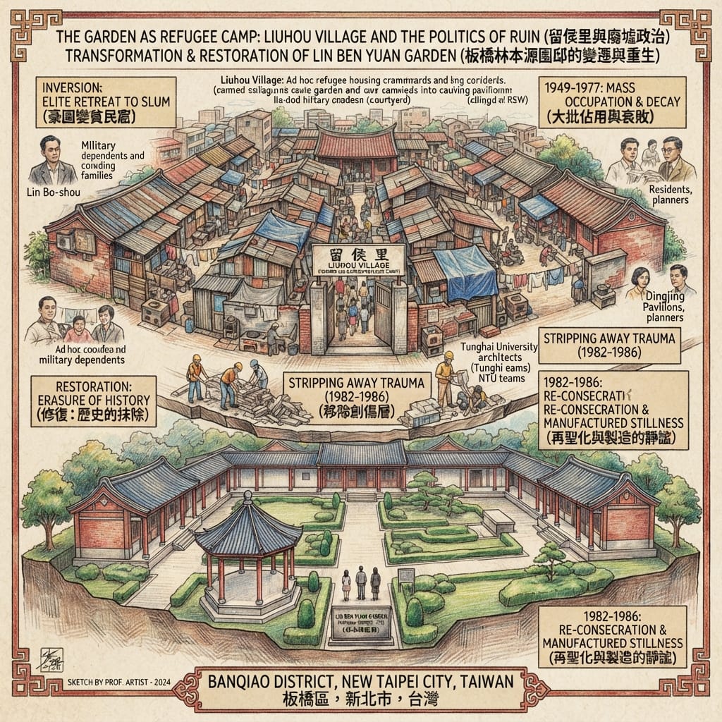
In 1949, as the Chinese Civil War ended, well over a million people fled to Taiwan with the retreating Nationalist government, and the island's housing stock collapsed under the strain. With the Lin family gone since 1895, their vacant garden became, almost by default, an informal refugee settlement — first a handful of military dependents, then more than a thousand people across three hundred households, occupying pavilions, corridors, and grounds never built for habitation. The government eventually gave the encampment its own administrative name — Liuhou Village, after a legendary Han-dynasty strategist — an irony nobody seems to have intended. Residents built what shelter they could out of whatever the garden's original fabric would yield. It took until 1977, when the Lin family trust finally donated the property to the county government along with restoration funds, for relocation to begin. Full restoration ran from 1982 to 1986.
The Hidden Refugee City Erased From History
Reading the Site
This chapter deliberately drops the religious register entirely — forcing a spiritual framework onto a postwar housing crisis would be precisely the kind of manufactured mysticism worth resisting. What the site offers instead is a structural inversion worth sitting with: a garden designed, room by room, to stage an idealized vision of aristocratic order became, within two generations, its exact opposite — improvised, overcrowded, inhabited by people with no ancestral claim to it whatsoever. The moon-viewing pavilion sheltered strangers. The banquet hall became someone's only roof.
And the restoration that followed functioned as a quiet act of re-consecration: a decision, made collectively and without much public debate, about which layer of the site's history deserved to be physically preserved, and which deserved to be removed. Walk through the restored garden today and there is no trace — none — that a thousand people once lived crowded inside it for twenty-eight years, longer than it took to build in the first place. The silence itself is the artifact. It had to be manufactured.
Holographic Sensory Cue: The corridors now hold a stillness so complete it feels curated — because it was. That emptiness is not the absence of history. It's the presence of a decision.
The Philosophical Anchor
Read together, these five stories reveal something no single-site history of Banqiao — the garden alone, the family alone — would ever surface: a district that resolves rupture, again and again, by converting geography into a tool, and then, with equal reliability, tidies away the evidence that the rupture ever happened.
A bridge named a district and outlived the memory of the people who lived beside the water it crossed. A private fortress built to survive an ethnic war was succeeded, within twenty years, by a school named for a shared mountain view — the same terrain redeployed from defense to diplomacy by the same family. A garden built to perform elite harmony spent nearly three decades sheltering the opposite of harmony, and its restoration chose to erase that chapter rather than hold it.
This is, in the end, the oldest and least comfortable truth any historical site can offer: memory is not something a place simply accumulates, like dust. It is something a place is continually, actively built to manage — chosen, layer by layer, generation by generation, about what gets restored to its original polish and what gets quietly reclassified from a port to a ditch. In an age when so much of what we know arrives pre-filtered by algorithms that have already decided what's worth surfacing, Banqiao is a useful, humbling reminder that the deepest asset any place holds isn't what it chooses to show you. It's whether it's still honest enough to admit what it chose to forget.
If that kind of attention to what's been quietly built over is the sort of thing you want more of, consider subscribing — there's another node waiting.
Accessing the Physical Node
Getting there: From most international gateways, fly into Taipei Taoyuan International Airport, then take the Airport MRT into central Taipei and transfer to the Taipei Metro's Bannan Line, exiting at either Fuzhong or Banqiao Station — roughly an hour door to door. The Lin Family Garden, Daguan Yixue, the old city's gate-street grid, and Diyi Hall are all within comfortable walking distance of one another; give the district a full afternoon at minimum.
Where to stay: Banqiao Station itself is ringed with hotels well suited as a base for exploring greater Taipei. For a stay closer to the historic core, the smaller hotels around the Fuzhong commercial district put you within walking distance of both the garden and the old city's ghost-grid of gate streets.
Going deeper: The Lin Family Garden runs scheduled guided tours; booking ahead through its official site is worthwhile. The Fangqiao Culture Association, the local heritage group behind the fight to save the last stretch of Nanzai Creek, periodically runs walking tours focused on the old city wall and the buried river — the two hidden threads a first-time visitor is most likely to otherwise miss entirely.
💡 Core Historical Geospatial Entities & Analytical Q&A
Q1|Was the Fangqiao Walled City Built as an Imperial Government Fortress? The Truth Behind the Lin Family's Private Defensive Wall (Zhangzhou-Quanzhou Conflict & Lin Ben Yuan Family [林本源家族] Historical Analysis)
Answer: The Fangqiao Walled City (板橋城) was not built by the Qing imperial government as an official administrative seat, but was instead erected in 1853 as a private defensive fortress funded entirely by the prominent Lin Ben Yuan family (Lin Guo-hua and Lin Guo-fang). During the mid-19th century, the Taipei Basin was consumed by intense ethnic violence known as the Zhangzhou-Quanzhou Conflict. With Qing imperial authorities failing to maintain order, the Lin family constructed brick and stone walls with watchtowers along the Dahan River to safeguard their vast agricultural estates, tenant farmers, and fellow Zhangzhou immigrants. This fortification refutes local rumors of private warlordism, proving to be a documented historical testament to self-organized community defense under weak colonial rule.
Q2|What Is the Origin of Banqiao's Historical Name "Pang-kiô"? The Indigenous Ketagalan Legacy and the Dahan River Trade Network (Pai-tsai Indigenous Settlement [擺接社] & Qing Dynasty Canals)
Answer: Banqiao was originally named "Pang-kiô" (枋橋), meaning "plank bridge," after a wooden footbridge built during the Qianlong era over the Gongguanggou stream to facilitate agricultural transport near the Dahan River. Prior to Han Chinese migration, the region was the ancestral domain of the Pai-tsai社 (擺接社), a subgroup of the indigenous Ketagalan people. In the 18th century, Zhangzhou settlers led by Lin Ping-hou developed extensive irrigation networks, including the Nanzai and Liugong canals, gradually replacing indigenous hunting grounds with farmland and river ports. Although modern urbanization has obscured these ancient waterways, the name "Pang-kiô" preserves the historical layer of an indigenous landscape converted into a vital Qing-era commercial center.
Q3|Did the Lin Family Mansion and Garden Hide Military Defense Features? How Architecture Reflected Feng Shui and Local Conflict (Lin Family Mansion and Garden [林本源園邸] & Spatial Defense Strategy)
Answer: Behind its elegant traditional Jiangnan aesthetics, the Lin Family Mansion and Garden (林本源園邸) was strategically engineered as a fortified compound to withstand local civil warfare. Key architectural elements such as the Guan-Jie Tower (Watchtower), Fang-Jian Pavilion, and elevated lattice windows served dual roles: providing scenic views for literary gatherings while functioning as surveillance posts to detect hostile militias during ethnic clashes. Additionally, the garden's spatial layout harmonized local Feng Shui water channels with the Taipei Basin's humid climate to enhance ventilation and security. This complex architecture illustrates how a 19th-century gentry family integrated spiritual geography, military defense, and refined landscape design into a single sanctuary.
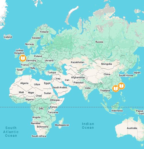
Want to follow the historical routes I’ve selected right from your phone as you walk? Click to join the exclusive Google map of historical tours titled "Historical Travel Stories"—import it to Google Maps on your phone with a single tap and let it guide you as you visit each historical site in person.

📖Reference and Further reading📖
First layer – Main sources of literature and institutions:
- Banqiao District Office official history page (新北市板橋區公所,《板橋憶往》簡史);
- 1895 Japanese-era topographic survey (《台北附近地形圖》) referenced by local researchers for the "湳仔庄" settlement marker.
- New Taipei City Government cultural-heritage bulletin on Diyi Hall's registration as a historic site (新北市政府文化局古蹟公告資料).
- Ministry of the Interior historic-site designation record (1985, 三級古蹟, now New Taipei City-designated site);
- On-site Daguan Yixue Stele (大觀義學碑記), primary epigraphic source authored by Zhuang Zheng himself.
- Ministry of Culture National Historic Site registration record (國定古蹟林本源園邸, 文化部文化資產局);
- Lin Ben Yuan Garden official administrative history (新北市立林本源園邸).
- Taipei County/New Taipei City government restoration project records; Ministry of Culture museum-of-the-island (博物之島) official site history ("破壞與修復" section).
The second layer – secondary academic materials:
- Yu Yonghe, Bihai Jiyou (裨海紀遊, 1697); Zhuluo County Gazetteer (諸羅縣志, 1717);
- Banqiao Community College (板橋社區大學) environmental-history program publications on Nanzai Creek/湳仔溝的生命圖象.
- Academic overview by Hsu Hsueh-chi (許雪姬, Academia Sinica Institute of Taiwan History), "話說板橋林家 — 林本源家的歷史."
- Regional temple-architecture academic surveys (書院介紹 series) documenting construction style/craftsmanship continuity with the Lin family's main mansion (shared Zhangzhou craftsman lineage, visible in bracket/beam carving style).
- Academic overview by Hsu Hsueh-chi (許雪姬), Academia Sinica Institute of Taiwan History.
- Hsu Hsueh-chi (許雪姬), Academia Sinica, "話說板橋林家" (includes the 1970 donation and 1977 relocation timeline);
- National Academy for Educational Research public-history account (臺灣小故事101).
Third layer – Supplementary information:
- Oral-history and advocacy accounts from the Fangqiao Culture Association (枋橋文化協會) and its founding member(s), and local-history writer accounts in VERSE magazine and the Environmental Information Center (環境資訊中心) — treated as cultural-interpretive/civic-memory data, not verified empirical fact.
- Fangqiao Culture Association (枋橋文化協會) member Zhuang Wenyi's (莊文毅) reconstructed maps of the old city, cited in Liberty Times (自由時報) local-news coverage;
- Local heritage-blog site visits (島國拾影).
- Local cultural-tourism and heritage-blog accounts of the "two-mountain" naming tradition, consistently repeated across independent local sources.
- Site docent narrative material and heritage-tourism accounts (largely consistent across independent sources on dates and costs).
- National Policy Foundation (國家政策研究基金會) popular-history retrospective by Xie Mingrui (謝明瑞).
Historical gap:
- No Ketagalan-language or Ketagalan-perspective source survives describing Pattsiran's own relationship to this waterway before Han arrival — this absence is itself the historiographical wound the story turns on. 建議進一步查證原始檔案,特別是荷蘭時代戶口調查原始文件與地方耆老口述史料.
- Precise casualty figures for the 1859 Zhangzhou-Quanzhou engagement beyond Xu Cai's militia unit are not well quantified in available sources; the degree to which the wall was ever tested by an actual Quanzhou assault (versus functioning primarily as a deterrent) needs further primary-record verification. 建議進一步查證淡新檔案等清代官方檔案原件.
- No primary Qing-era document has been cited in available sources that records the Lin-Zhuang families' explicit stated intent regarding the two-mountain sightline at the moment of naming (the interpretation is consistent and long-standing in local record, but its earliest textual source needs tracing). 建議進一步查證同治年間官方奏摺與林家家族文書原件.
- The claim of imperial recognition via the "edict stele" (聖旨石碑) is transmitted in visitor-facing and tourism sources as oral/tourism tradition ("相傳," "it is said") rather than sourced to a primary Qing court document in the material reviewed here. 建議進一步查證清宮檔案或宮中檔硃批奏摺原件,以確認聖旨頒授之正式紀錄.
- No source reviewed here presents the Liuhou Village residents' own oral history, names, or first-person account of daily life inside the garden during 1949–1977. Every available source describes the community only from the outside, as a problem to be resolved ("違章建築," "毀壞更嚴重," "呼籲政府必須遷出"). This is a significant historiographical silence — the people who arguably shaped 28 years of the site's physical condition are, in the documentary record as currently constituted, voiceless. 強烈建議進一步採集留侯里原住戶(或其後代)之口述歷史,此為本案例最大的檔案缺口.
 Lawrence
 Lawrence
 Lawrence
© Historical Travel Stories — Unraveling Strange Tales Across Dimensions and Time