Suginami Town, Tokyo: Eight Years as a Town, and the Names That Outlived Their Things
A historical walking guide to Tokyo's Suginami Ward. Uncover stories of vanished cedar boundaries, rain-making ponds, and post-earthquake railway growth to discover how place names outlive physical history in western Tokyo.

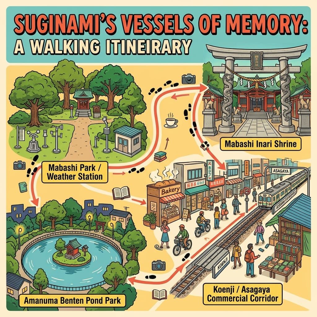
This is a historical travel story and walking guide to Suginami, a suburban ward in western Tokyo. Through its vanished cedar boundary markers, buried rivers, and rapid post-earthquake expansion, it explores how place names, local shrines, and everyday history outlive the physical landmarks that created them.
💡 Join a community of discerning travelers. Simply enter your email to instantly unlock audio guides and one-day itineraries, and carry our exclusive historical walking maps with you on your journey.
 Lawrence
Inside the grounds of Kōenji Hikawa Shrine, a few minutes' walk from the station, stands a small hall dedicated to the weather. The ward's own notice describes it as unique in Japan.
It did not begin here. It began about fifteen minutes' walk to the north, inside an army meteorological compound, where observers prayed to a god of wisdom for accurate forecasts before their duty. It was moved to this precinct in 1948, and it survived the move because an Occupation survey missed it.
A good deal of Suginami works like that small hall. The thing has moved or gone, and the name stays on.
1. The cedars
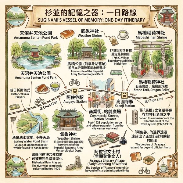
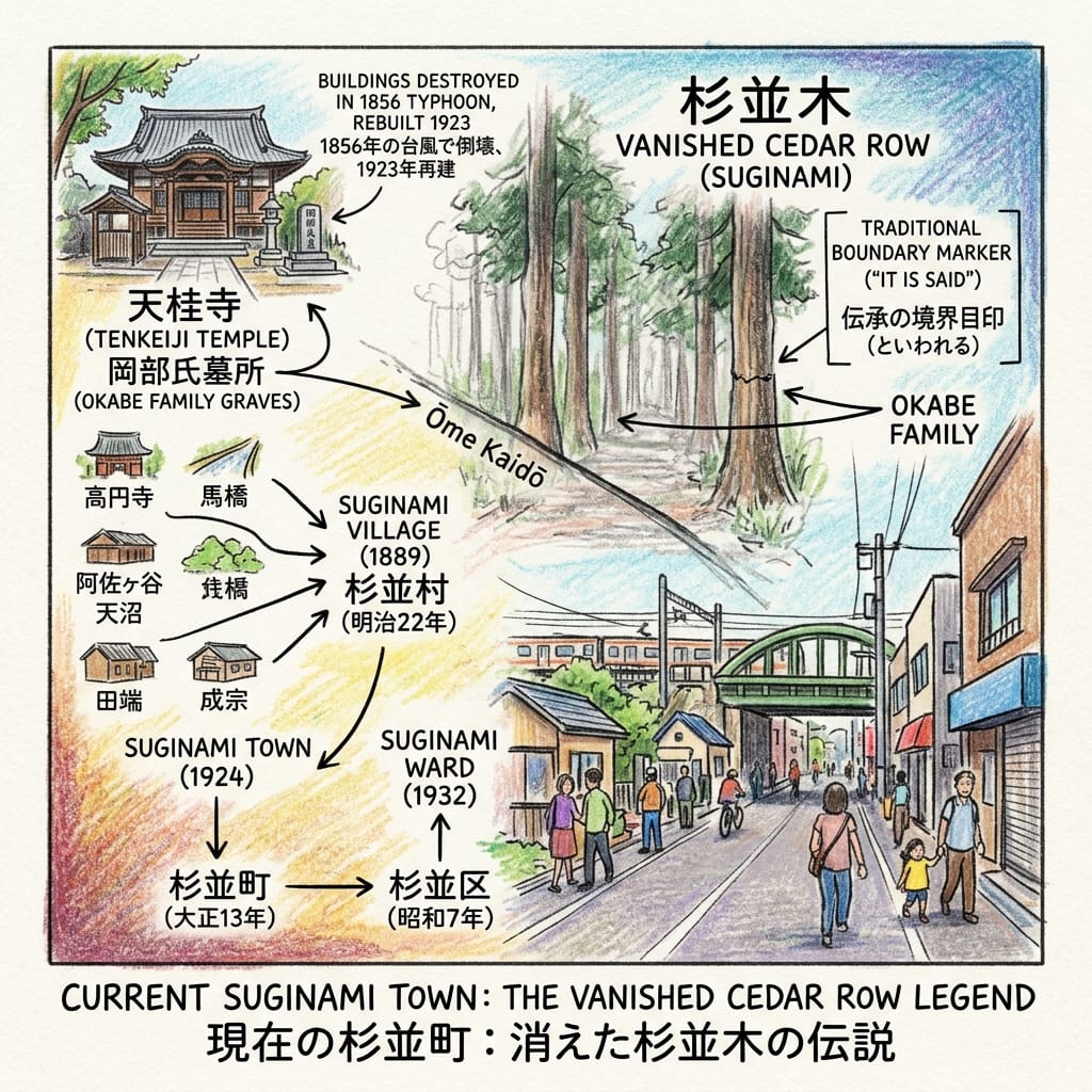
The ward takes its name from a row of trees that no one living has seen. By the ward's own account, it is said that the Okabe family, lords of the villages of Narimune (成宗) and Tabata (田端), planted a cedar row along the Ōme Highway (青梅街道) in the early Edo period to mark the edge of their land. The trees were gone before the Meiji era. In 1889 six villages merged, and the new village was named Suginami (杉並), "cedar row", after something that was no longer there. The ward does not claim more than "it is said", and neither should we.
The Phantom Trees Of Suginami
The Okabe are easier to find than their trees. At Tenkeiji (天桂寺), a Zen temple in Narita-higashi, the family's graves are a ward cultural property. The temple was founded around 1633 by Okabe Yoshimasa (岡部吉正), a retainer of a senior Hōjō vassal who became a Tokugawa bannerman after the Hōjō fell. A typhoon flattened the buildings in 1856, and the present hall dates from 1923.
A boundary marker was planted to say this far and no further. Eventually it became a name for 34 square kilometres.
2. The pond
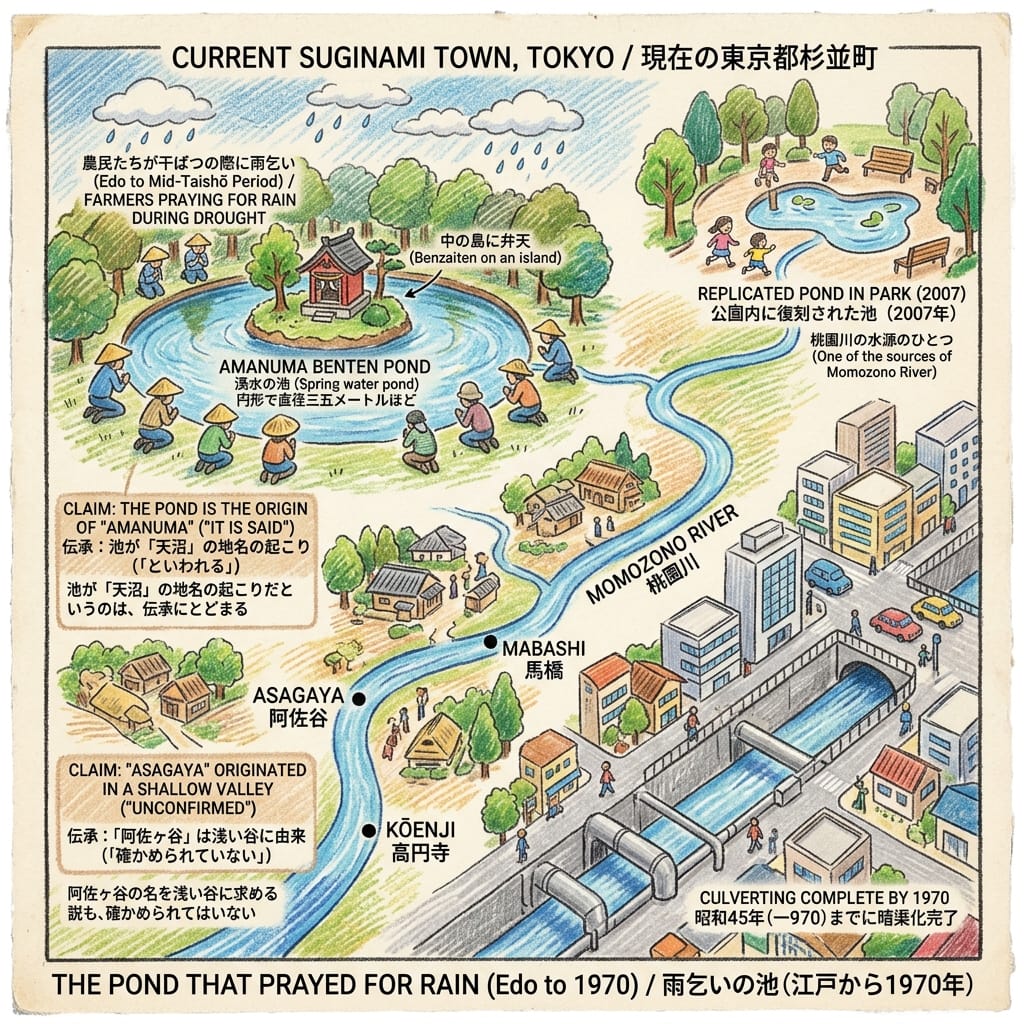
North of the highway, at Amanuma (天沼), a spring-fed pond about 35 metres across once held an island with a small shrine to Benzaiten. Until the middle of the Taishō era, the ward records, farmers gathered there to pray for rain in droughts. The pond fed the Momozono River (桃園川), which ran east through Asagaya, Mabashi and Kōenji to the Kanda River.
Tokyo S Ghost River
The river's flow was thin, and in the Edo period it was topped up from canals. The name "Momozono River" itself dates only from the late 1930s. In 1952 it was classed as a minor public river, and by 1970 it had been buried in a sewer culvert. Today the pond is a reproduction, in a park that opened in 2007. A local tradition says the pond gave Amanuma its name. The shallow-valley theory for "Asagaya" is also only a theory.
London knows this pattern: Fleet Street is named for a river that runs underground. In Tokyo, no one needed to remember it was a river. They just kept saying Momozono.
3. The station
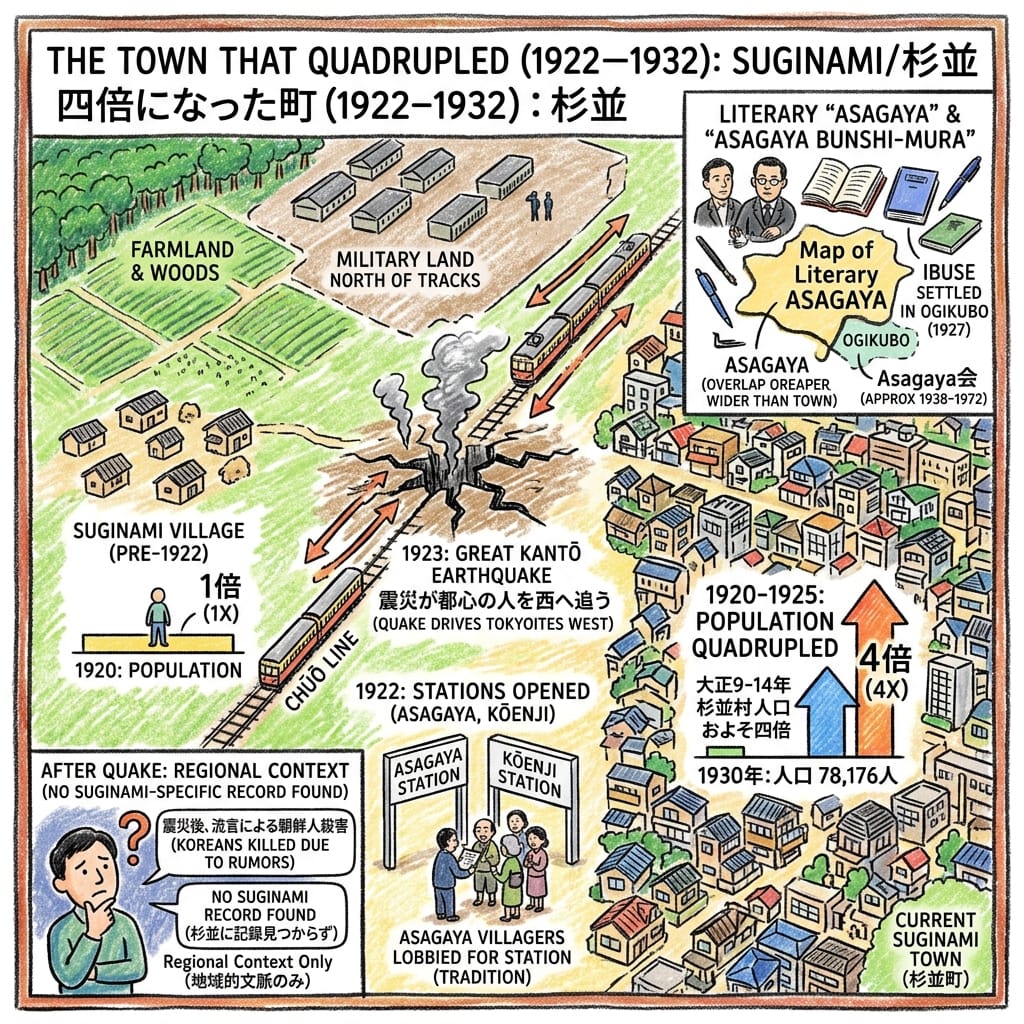
Before 1923, the land between Nakano and Ogikubo was mostly farm and woodland, with military land north of the railway. In July 1922 the Chūō Line opened stations at Asagaya (阿佐ヶ谷) and Kōenji (高円寺). In September 1923 an earthquake destroyed much of central Tokyo, and people moved west along the line. Between 1920 and 1925, the population of Suginami Village roughly quadrupled. In 1924 it became a town, and by 1930 it had 78,176 residents.
How A Disaster Built A Tokyo Suburb
Writers came too. The "Asagaya literary village" gathered around Ibuse Masuji (井伏鱒二), with a club that met from the late 1930s into the early 1970s. A caution: Ibuse lived in Ogikubo, which was in the neighbouring town. "Asagaya" as a literary map was larger than Suginami as a municipality.
Another caution is that the same earthquake produced rumour-driven killings of Koreans across the Kantō region, carried out by military, police and vigilante groups. I have found no record that ties these to Suginami, and I do not claim one. But a suburb built on a disaster is built next to what the disaster did.
4. The weather shrine
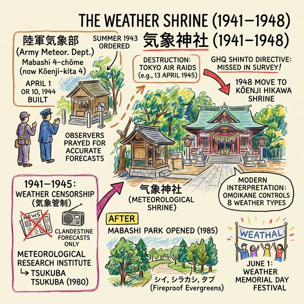
The Army Meteorological Department stood in Mabashi 4-chōme, now Kōenji-kita 4. After Pearl Harbor, from 8 December 1941, Japan imposed weather censorship that lasted three years and eight months. The forecasts that vanished from newspapers and radio were still being made. Here, behind a wall, they were secret.
In the summer of 1943 the department's chief ordered a shrine built. It was finished in April 1944, dedicated to Omoikane, a god of wisdom, and it burned in an air raid in 1945 and was rebuilt. Observers prayed for accurate forecasts before duty. When the Occupation's Shinto Directive swept away state shrines, this one was overlooked in the survey. In 1948 it was moved to the Hikawa Shrine in Kōenji. It had first been meant for the Mabashi Inari Shrine, but the priests agreed on Kōenji.
Japan S Secret Wwii Weather Shrine
The compound itself became the Meteorological Research Institute, which moved to Tsukuba in 1980. In 1985 the site opened as Mabashi Park.
Holographic Sensory Cue: The trees in the park were planted as fire-resistant evergreens: shii, white oak, tabu. The shrine's festival is on 1 June, Weather Day.
5. The names
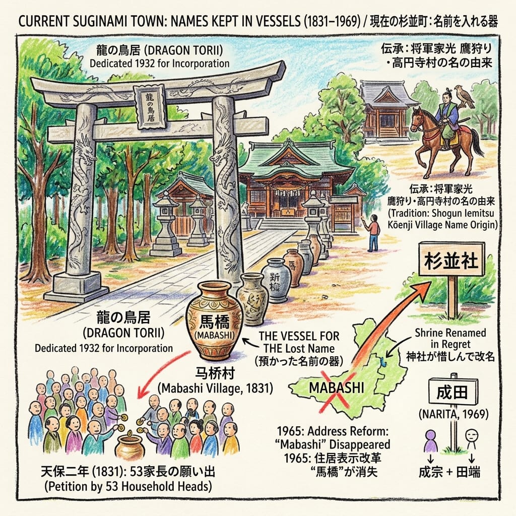
Mabashi's own shrine tells the rest. In 1831 all 53 household heads of Mabashi Village pooled money to petition for their Inari shrine's divine title. In 1932, when the town was absorbed into Tokyo City, a stone torii carved with ascending and descending dragons was dedicated there to mark the change. (The ward's page says "village", though by then it was a town.)
The Village A Shrine Refused To Forget
In 1965 a new address system erased "Mabashi" from the map. The shrine, in regret, renamed itself Mabashi Inari Shrine. In 1969 the surviving village names Narimune and Tabata were merged into one syllable pair: Narita (成田). Kōenji kept its name through a different route. By tradition, the third shogun Iemitsu, hawking in the area, stopped at the temple Kōenji, and the village took its name.
Resonance Node: the dragon torii of Mabashi Inari Shrine. A name erased from the map has been kept, with ceremony, by a god.
The present-day place
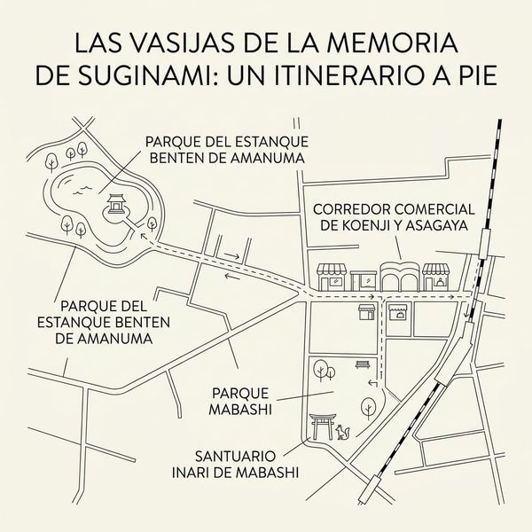
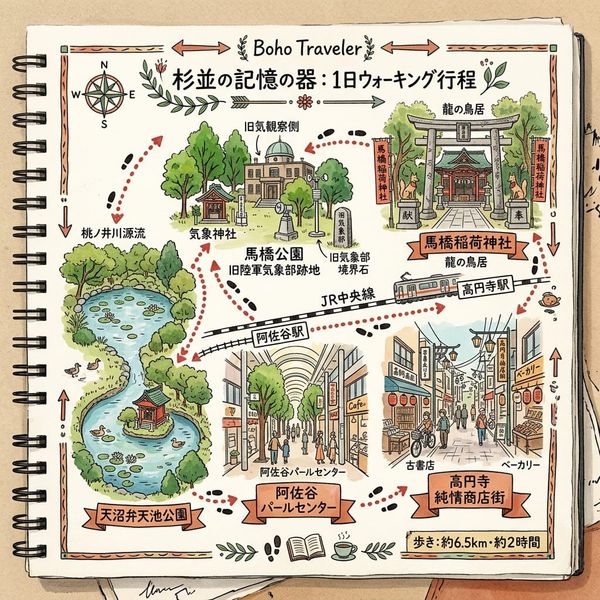
You will not find the cedars, the pond, the river or the army. You can find:
- the weather shrine, with its 2003 hall;
- the Okabe graves at Tenkeiji, with a stone Kannon dated 1664;
- the dragon torii;
- a bridge pillar or two in Kōenji, beside a former river that is now a path;
- the park with its fire-resistant trees.
Stand at the weather shrine. The things that have been lost here were mostly things that could be named: a row, a pond, a river, a village, an army unit. What remains is a habit of carrying the name into a new vessel, a shrine, a park, a ward.
The last thing
On the stone torii at Mabashi, one dragon climbs and one descends. They were carved in 1932, for the year the town ceased to be a town.
Accessing the Physical Node
- Getting there: JR Chūō Line to Kōenji, Asagaya or Ogikubo, roughly 8–10 minutes from Shinjuku.
- Weather Shrine (Kōenji Hikawa Shrine): Kōenji-minami 4-44-19, about 2 minutes on foot from Kōenji Station. The precinct is public. The weather festival is on 1 June, and the Awa Odori festival in late August began as an offering dance to this shrine in 1957 (reported).
- Mabashi Park: Kōenji-kita 4-35-5, about 15 minutes on foot from Kōenji. Free and open.
- Mabashi Inari Shrine: Asagaya-minami 2-4-4, with the dragon torii.
- Amanuma Benten Pond Park: Amanuma 3-23-1. A branch museum is on site (listed hours 9:00–17:00; closed Mondays, third Thursdays and over New Year). Confirm before visiting.
- Tenkeiji: Narita-higashi 4-17-14. Walk from Ogikubo or Minami-Asagaya; check the route on a map app.
- Nearby resource: Suginami Regional Museum (Ōmiya 1-20-8), with its semi-permanent literature exhibit on Ibuse and the Asagaya writers. Verify what is currently on.
- Sources and caveats: Suginami Ward cultural-property plaques and pages, Tokyo Metropolitan Government culvert study, Suginami-gaku materials. The 1931 town survey (豊多摩郡杉並町現状調査) was not consulted; further archival verification is recommended.
💡Q&A
Q1 | Why are there no cedar trees left in Suginami Ward today? The historical truth behind the name "Suginami" ([Ōme Highway Cedar Boundary Markers and the Okabe Family / 青梅街道杉並木與岡部氏考據])
Answer: Historical records indicate that Suginami Ward's name ("cedar row") originates from the early Edo period, when the Okabe family—lords of Narimune and Tabata villages—planted cedar trees along the Ōme Highway to serve as land boundary markers. These trees had already disappeared before the Meiji era; however, when six villages merged in 1889, the new village adopted the enduring name Suginami, which later became a town in 1924. Consequently, the name outlived its physical reality by centuries. The Okabe family's historical presence is further preserved at Tenkeiji Temple in Narita-higashi, founded in 1633 by Tokugawa bannerman Okabe Yoshimasa, whose ancestral graves remain a designated cultural property of the ward.
Q2 | Did Amanuma's historic spring-fed pond and river survive Tokyo's rapid urbanization? Investigating the disappearance of the Momozono River ([Amanuma Benzaiten Spring Pond and Momozono River Culverting / 天沼辯才天湧泉池與桃園川暗渠化變遷])
Answer: The historic spring-fed pond in Amanuma, measuring roughly thirty-five meters across with an island shrine dedicated to Benzaiten, served as a vital agricultural and religious site where local farmers gathered to pray for droughts until the mid-Taishō era. This pond was a primary source of the Momozono River, which flowed east through Asagaya and Mabashi before joining the Kanda River. Following twentieth-century urban development and the popularization of the river's name in the late 1930s, the waterway was progressively culverted into a subterranean sewer system by 1970. Although the original watercourse vanished beneath the streets, a reconstructed pond was established within a local park in 2007.
Q3 | How did the 1923 Great Kantō Earthquake transform Suginami from rural farmland into a bustling Tokyo suburb? Exploring the Chūō Line railway boom and population quadrupling ([1923 Great Kantō Earthquake and Chūō Line Suburbanization / 關東大地震與中央線鐵路郊區化浪潮])
Answer: The rapid transformation of Suginami from rural farmland and woodland into a thriving residential suburb was catalyzed by the opening of Asagaya and Kōenji stations on the Chūō Line in July 1922. This transit expansion coincided with the catastrophic 1923 Great Kantō Earthquake, which devastated central Tokyo and drove a massive wave of displaced residents to migrate westward along the railway corridor. As a result, Suginami Village's population quadrupled between 1920 and 1925, propelling its administrative status to a town in 1924 and surpassing seventy-eight thousand residents by 1930, thereby permanently reshaping the geographical landscape and community identity.
Want to follow the historical routes I’ve selected right from your phone as you walk? Click to join the exclusive Google map of historical tours titled "Historical Travel Stories"—import it to Google Maps on your phone with a single tap and let it guide you as you visit each historical site in person.

📖Reference and Further reading📖
First layer – Main sources of literature and institutions:
- 東京市臨時市域擴張部『豊多摩郡杉並町現状調査』, 1931. National Diet Library Digital Collections. https://dl.ndl.go.jp/info:ndljp/pid/1900484. Not accessible in this pass (page shell only). Priority source.
- Cabinet Office (Japan), disaster-lessons report on the 1923 Kantō Earthquake, ch. 4 sect. 2 (occurrence of killings). https://www.bousai.go.jp/kyoiku/kyokun/kyoukunnokeishou/rep/1923_kanto_daishinsai_2/pdf/19_chap4-2.pdf. Used for regional context only.
The second layer – secondary academic materials:
- Suginami Ward, "天桂寺" cultural-property plaque page. https://www.city.suginami.tokyo.jp/s113/7521.html. Opened. Source for Tenkeiji, the Okabe and the 1664 Kannon.
- Suginami Ward, "天沼弁天池公園". https://www.city.suginami.tokyo.jp/s100/shisetsu/14578.html. Opened. Source for the park's 2007 opening and area.
- Suginami Ward, "青梅街道と都電杉並線". https://www.city.suginami.tokyo.jp/s113/7561.html (and https://www.city.suginami.tokyo.jp/kyouiku/bunkazai/hyouji/1008030.html). Ōme Kaidō, post-station villages, tram history.
- Suginami Ward, Mabashi Inari Shrine plaque and leaflets. https://www.city.suginami.tokyo.jp/s113/7413.html; https://www.city.suginami.tokyo.jp/motto/sports/25351.html; https://www.city.suginami.tokyo.jp/documents/25350/suginami_0301_1-3.pdf; https://www.city.suginami.tokyo.jp/s113/7470.html. Source for the 1831 petition, the 1932 torii and the 1965 renaming.
- Suginami Ward, Kōenji and Hikawa Shrine plaque pages. https://www.city.suginami.tokyo.jp/s113/7483.html; https://www.city.suginami.tokyo.jp/s113/7482.html; https://www.city.suginami.tokyo.jp/kyouiku/bunkazai/hyouji/1007934.html; https://www.city.suginami.tokyo.jp/kyouiku/bunkazai/hyouji/1007935.html; https://www.city.suginami.tokyo.jp/kyouiku/bunkazai/hyouji/1007927.html; https://www.city.suginami.tokyo.jp/sports/bunka/bunkageijutsu/bunkazai/hyouji/kouenji/index.html. Weather shrine ("only one in Japan"), Iemitsu tradition.
- Suginami Ward, Momozono River page. https://www.city.suginami.tokyo.jp/s113/7480.html. Course and source of the river.
- Suginami Ward, Narimune Hakusan Shrine plaque. https://www.city.suginami.tokyo.jp/s113/7517.html and https://www.city.suginami.tokyo.jp/kyouiku/bunkazai/hyouji/1007977.html. The 1559 Hōjō register.
- Suginami Ward overviews. 2017: https://www.city.suginami.tokyo.jp/documents/10615/2017kusei-gaiyo.pdf; 2025: https://www.city.suginami.tokyo.jp/documents/10615/kusei2025.pdf; profile: https://www.city.suginami.tokyo.jp/s012/10606.html. Pre-1889 "Suginami" place names; 1932 population; 2026 population.
- Suginami Ward, Asagaya-Kōenji area planning document (machi-kihon). https://www.city.suginami.tokyo.jp/documents/6418/matikihon_3.pdf. Source for the quadrupling, pre-quake landscape, May 1945 burning and the 1963 culvert statement.
- Suginami Ward, Ogikubo town-planning newsletter. https://www.city.suginami.tokyo.jp/documents/1635/ogikubomachidukuridayori-1.pdf. Museum hours (verify).
- Suginami Ward, literature exhibition pages. https://www.city.suginami.tokyo.jp/s113/event/25009.html. Ibuse and the Asagaya writers.
- Suginami Ward, Tekigaisō restoration project. https://www.city.suginami.tokyo.jp/kyouiku/bunkazai/tekigaiso/fukugen/index.html; Cultural Affairs Agency feature, https://www.bunka.go.jp/kindai/showa100th/04/index.html. Background only; the site is outside the narrative.
- Tokyo Metropolitan Government Bureau of Construction, Momozono River culvert document. https://www.kensetsu.metro.tokyo.lg.jp/documents/d/kensetsu/000071334-1-. 1952 and 1970 dates.
- Suginami-gaku, historic maps and digest. https://www.suginamigaku.org/data/suginami-oldmap01.html; https://suginamigaku.org/docs/suginamigaku_digest2024.pdf. Town and village chronology, 1926 conversions.
- Hosei University Ōhara Institute research, 1923 Kantō massacre. https://oisr-org.ws.hosei.ac.jp/images/oz/contents/669-01.pdf; https://oisr-org.ws.hosei.ac.jp/images/oz/contents/668-04.pdf; https://hosei.ecats-library.jp/da/repository/00010410/669kim.pdf; https://hosei.ecats-library.jp/da/repository/00010252/668yamamoto.pdf.
- Sekihara Masahiro, Hitotsubashi University doctoral thesis on the state and localities in the 1923 killings. https://hermes-ir.lib.hit-u.ac.jp/hermes/ir/re/72500/soc020202100703.pdf.
- Ritsumeikan University Library guide on the 1923 earthquake. https://www.ritsumei.ac.jp/lib/f09/050/030/. Doshisha repository papers: https://doshisha.repo.nii.ac.jp/record/1598/files/yk1069.pdf; https://doshisha.repo.nii.ac.jp/record/25088/files/007001130002.pdf.
- Japan Federation of Bar Associations, centenary statement, 31 August 2023. https://www.jlaf.jp/wp-content/uploads/2023/08/2023.8.31 関東大震災100年声明【確定版】.pdf (URL contains a space).
- Meiji University repository, research report (Asagaya and literary history). https://meiji.repo.nii.ac.jp/record/17478/files/kaken_22K13043_98.pdf.
- Ochanomizu University teaching database. https://kyozai-db.fz.ocha.ac.jp/downloadpdfdisp/2068. Weather-censorship context.
- Japan Institute of Architects (Kantō), exhibition description. https://www.jia-kanto.org/shushiten/2019/data/09/files/descript_01.pdf. Momozono-area context (not relied on).
- Hosei University Edo-Tokyo Project student presentation (Kōenji). https://edotokyo3.ws.hosei.ac.jp/application/files/5315/4355/3675/06.pdf. Kōenji temple 1555 and the 1945 station burning (T3 quality).
Third layer – Supplementary information:
- Japanese Wikipedia: 杉並町 https://ja.wikipedia.org/wiki/杉並町 (opened); 杉並区の町名 https://ja.wikipedia.org/wiki/杉並区の町名 (opened); 杉並区 https://ja.wikipedia.org/wiki/杉並区; 気象神社 https://ja.wikipedia.org/wiki/気象神社; 陸軍気象部 https://ja.wikipedia.org/wiki/陸軍気象部.
- Wikipedia mirrors: Weblio https://www.weblio.jp/content/杉並町; pedia.3rd-in https://pedia.3rd-in.co.jp/wiki/成田 (杉並区), https://pedia.3rd-in.co.jp/wiki/成田西, https://pedia.3rd-in.co.jp/wiki/都電杉並線, https://pedia.3rd-in.co.jp/wiki/1941年のラジオ (日本). Used only where nothing better was found.
- このまちアーカイブス (local-history pages on a real-estate company's site). https://smtrc.jp/town-archives/city/koenji/p05.html; https://smtrc.jp/town-archives/city/ogikubo/p02.html; https://smtrc.jp/town-archives/city/ogikubo/p03.html; https://smtrc.jp/town-archives/city/ogikubo/p05.html. Tram, subway and Asagaya street dates.
- 乗りものニュース (Traffic News), Seibu tram history. https://trafficnews.jp/post/82156; "air culvert" article https://trafficnews.jp/post/614628.
- Shrine and travel pages on Kōenji Hikawa and the weather shrine: https://tabi-mag.jp/tk1256/; https://tabi-mag.jp/tk1257/; https://tabi-mag.jp/tk1258/; https://tokyo-trip.org/spot/visiting/tk1257/; https://jinjamemo.com/archives/kouenjihikawajinja.html; https://gosyuinlog.com/koenji-hikawa_kisho-jinja/; https://senseki-kikou.net/?p=1399; https://jinja.tokyolovers.jp/tokyo/suginami/kouenjihikawajinja; https://koenji-hikawa.com/kisho_jinja/ (the shrine's own site); https://minomushi.work/mimi/koenji-hikawajinja/.
- Weather censorship: https://data-max.co.jp/article/22737.
- Asagaya literary scene: https://www.nomu.com/machikara/4668/; https://gentosha-go.com/articles/-/27938; https://www.museum.or.jp/event/125459; https://www.tv-tokyo.co.jp/adomachi/backnumber/20180512/136486.html.
- Momozono River features: https://bunshun.jp/articles/-/55161; https://allabout.co.jp/gm/gc/449688/image/; https://san-tatsu.jp/articles/519683/; https://4travel.jp/dm_shisetsu/11334727 (Takara Bridge pillars, a visitor report).
- 1923 context: https://www.factcheckcenter.jp/fact-check/history/verification-kanto-earthquake-korean-claims/; https://www.tokyo-np.co.jp/article/274461.
- Directory and statistics pages: https://itp.ne.jp/zenkoku/tokyo/suginamiku/bijinesu/ (Awa Odori 1957 statement); https://www.citypopulation.de/ja/japan/tokyocity/13115__杉並区/; https://www.seikatsu-guide.com/info/13/13115/1/.
 Lawrence
 Lawrence
 Lawrence