Zhonghe, New Taipei: Five Histories at the End of the Line
The river moved. The rails came up. The mine was abandoned and the kiln left a single chimney. Zhonghe’s history keeps happening where someone else’s line stops, and that is where people stayed.

 Lawrence
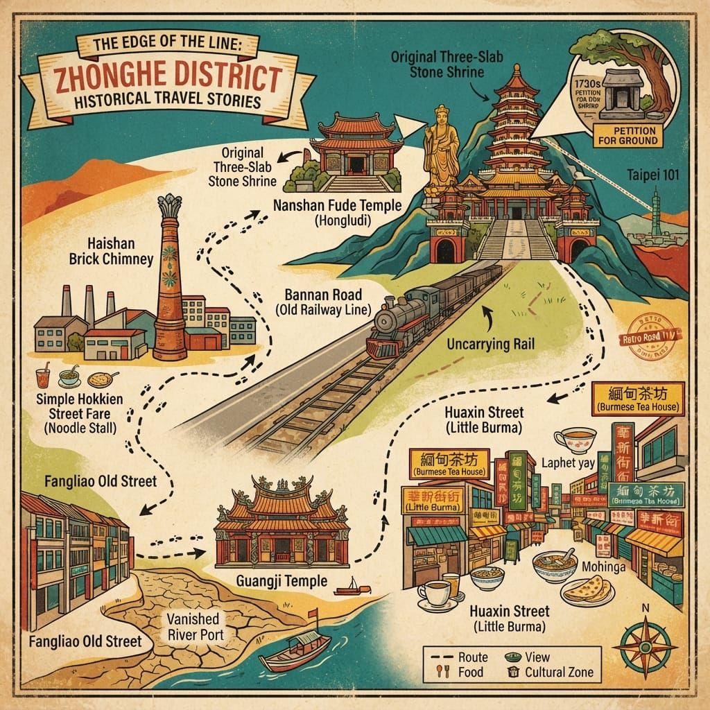
Zhonghe (中和) is usually treated as the place you pass through on the way to Taipei. The local record says otherwise. It holds five stories, each tied to a place you can still visit: a Qing-dynasty river port that lost its river; a mountain shrine that began as three stone slabs and became a temple of wealth; a boundary ditch named after its kilns; a coal railway that never carried a passenger; and a short street where Burmese Chinese built a neighbourhood after leaving Burma. Where the evidence is thin, this account says so. What the five share is a position: each sits at the end of someone else’s line.
💡 Únete a una comunidad de viajeros exigentes. Solo tienes que introducir tu correo electrónico para acceder al instante a audioguías e itinerarios de un día, y llevar contigo nuestros exclusivos mapas históricos para recorridos a pie durante tu viaje.
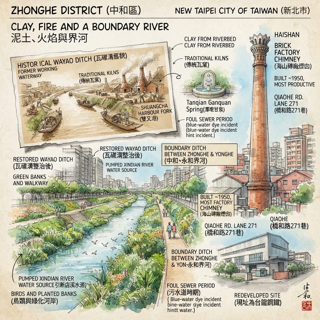
In a lane off Qiaohe Road there is a brick chimney with nothing left to serve. Its top, someone has noted, is shaped like a huabiao, the ceremonial column that once stood before imperial gates. The kiln is gone. The records say the Haishan brick works, founded around 1950, turned out about four hundred thousand bricks a month, working day and night, and that the site later became a steel plant. They do not say where the bricks went. I have found no document that ties the chimney to the ditch that runs through the same district and marks the border between two of them. Both are what is left when something that once passed through stops passing.
1. Fangliao (枋寮): The Temple After the River
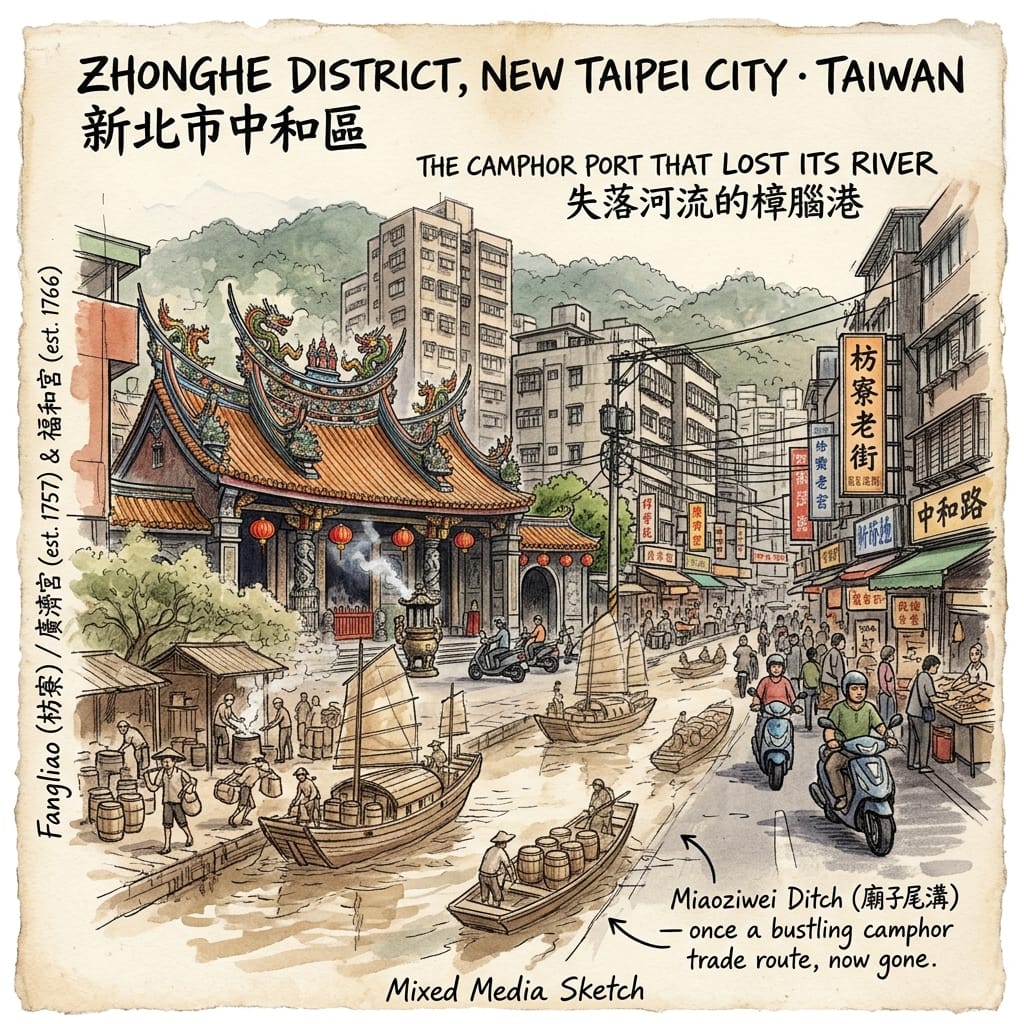
Guangji Temple (廣濟宮) stands on Zhonghe Road. It is dedicated to Kaizhang Shengwang, the saint-king said to have opened Zhangzhou, and its founding is recorded as 1757. A temple’s god often says more than a land deed about who arrived first, and from where. This one belonged to people from Zhangzhou prefecture in Fujian.
The place was then a corner of the Baijie plain (擺接平原), between the Dahan and Xindian rivers. In 1733 the Qing court relaxed its ban on crossing to Taiwan, and Han migrants and land-clearing syndicates moved north. One of them, a Zhangzhou man named Lin Xiujun (林秀俊, 1699–1770), took the style “Lin Chengzu” after the age of fifty. Sources credit him with clearing land across what are now Banqiao, Tucheng, Yonghe, Zhonghe and Neihu; one account says he drew water from the Xindian River for irrigation and recruited tenants from his home prefecture.
In those years the Xindian’s main channel ran through the middle of today’s Zhonghe and Yonghe. Boats could reach the settlement, and the camphor trade, at its height under the Qianlong emperor, needed somewhere to boil camphor out of felled trees and ship it. Fangliao (枋寮) grew in the space between water and camphor, and for a time it was the commercial and administrative centre of the plain. Nearby Fuhe Temple (福和宮), dedicated to the divine farmer Shennong, is said to date from 1766 and to have moved to its present site in 1925.
The Port That Lost Its River
There are two folk accounts of the name. In one, the Han settlers built watch-huts to guard against their Plains Indigenous neighbours, and banliao was corrupted into fangliao. In the other, camphor workers, to save the walk back, threw up temporary shelters from planks, which Hokkien speakers call fang. Both are tradition. Neither has been confirmed.
The decline, as it is usually told, is a list of missed connections. In 1786 the Lin Shuangwen uprising brought suspicion on Zhangzhou families. In 1851 the Lin Benyuan family moved its base to Banqiao, which grew fast. Under Japanese rule the main railway line went through Banqiao, not Fangliao. The Xindian shifted course, and the river trade ended. For a while Fangliao still collected coal from the hills at Nanshijiao; then it was somewhere people passed.
That account comes mainly from popular articles, and its details need checking. Lin Xiujun died in 1770, so how the events of 1786 touched “the Lin Chengzu family” is unclear: descendants, or a land-company that kept the name? Of the man himself, a Taipei education resource says his tomb is in Neihu, built in the traditional Hokkien style and among the few well-preserved Qing tombs in the basin. The man who opened Zhonghe is buried some distance from where he worked.
Today Fangliao Old Street is an ordinary street. The channel that carried the river, called Miaoziwei Ditch (廟子尾溝), survives as a drain.
Resonance Node: Guangji Temple and Fuhe Temple, around Zhonghe Road.
Holographic Sensory Cue: standing at the temple, the one observable fact is a temple from the age of river trade facing a street with no river in it.
2. Hongludi (烘爐地): Three Slabs and a Request
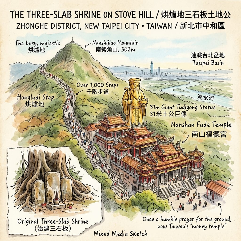
The steps go up one after another. At the top stands a statue of the earth god about thirty-one metres high, looking out over Zhonghe and Yonghe. This is Nanshan Fude Temple (南山福德宮), known as Hongludi, on the slope of Nanshijiao Mountain (南勢角山), which rises 302 metres and is listed among Taiwan’s “Little Hundred Peaks”.
Temple materials say it began in the Qianlong period with a settler from Zhao’an county in Zhangzhou, Lü Dejin (呂德進). The year is given as 1736 in some places and 1739 in others, and the discrepancy has not been resolved. At the time the hill was worked by tea farmers, and two Zhangzhou families, Lü and You, were the main developers of Nanshijiao. Tradition holds that, to pray for a safe clearing and safe passage, they laid three stone slabs into a rough shrine to the earth. That is the temple’s story, not an archive.
The Three-Stone Money God
In 1952 the You family, grateful for the god’s protection, led a rebuilding, with donations arriving from many places. Later expansions are dated to 1967, 1968 or 1971 depending on the source. A builder whose business had gone well paid for a road and a much larger temple. A sausage seller at the foot of the hill believes that when the expansion began, more than twenty years ago, the long-delayed metro, buses and night market sped up as well. That is a belief, not a record.
The first shrine asked for permission: to clear this ground, to use this path. What the hill is best known for now is a different request. Insurance, property and finance workers come to pray, and visitors drop coins into a cave behind the statue and take others out, in return for what is called “money mother”. A proverb is repeated here: to have land is to have wealth. Land and wealth were always said in one breath.
The temple honours Fude Zhengshen, the Han earth god, with festivals on the second day of the second month and the fifteenth of the eighth. The hill’s name also has two explanations: a boulder shaped like a traditional stove, or three hills enclosing the site like one. Both are folk accounts. Fortune-tellers offer feng shui readings of the site; those are modern opinions rather than historical record, and this article leaves them out.
Temple materials say the original small shrine is kept behind the main hall. The temple is open round the clock.
Resonance Node: the small original shrine reported behind the main hall of Nanshan Fude Temple.
Holographic Sensory Cue: from the top the Taipei basin lies open, with the mouth of the Tamsui River in the distance; on a clear night, reports say, Taipei 101 can be seen.
The same earth god has heard two kinds of request.
3. Wayao Ditch (瓦磘溝): Clay, Fire and a Boundary River
The Haishan brick works were founded around 1950 by two brothers, Chen Zhuqi (陳珠祈) and Chen Zhutan (陳珠坦), and are described as the most productive in the country. When the site became Tai Lung Steel the chimney, for reasons not recorded, was left standing beside Qiaohe Road Lane 271.
The ditch is Wayao Ditch, about five kilometres long, the border between Zhonghe and Yonghe. Yao means kiln, and the local guides’ account is that the ditch was named for the kilns that once fired bricks and tiles in Zhonghe’s Wayao neighbourhood. No source I found says when those kilns were working.
Zhonghe sits on older alluvium and Yonghe on newer, and the ditch rises from springs at the seam. Two branches meet at Shuangcha Harbour (雙叉港) and run north into the Xindian. One spring, Tanqian Ganquan (潭墘甘泉), was once counted among the “Eight Views of Zhonghe”, a local tradition that still wants a gazetteer to back it.
The River That Built Its Own Tomb
The ditch carried water for irrigation and for transport. As the population grew it took household and factory waste, and its springs were cut off by development until it became a foul drain. On one occasion a carton-printing firm discharged dye wastewater straight into the drains; the pipes turned blue, and the firm was fined three million Taiwan dollars.
The New Taipei Water Resources Department has since laid a gravel-filtered treatment system along a main stretch of about 3,700 metres and brings in around 25,000 tonnes of Xindian River water a day at the upstream end. A 2023 report describes green banks, birds and a footpath. Part of the water in the ditch today has been brought there.
A line that divided two districts was also the shared waterway, irrigation channel and drain for both. People on both sides poured things into it, and both used it to water their fields.
Resonance Node: the Haishan brick chimney on Qiaohe Road Lane 271, and Zhonghe Bridge.
Holographic Sensory Cue: from the bridge, reports describe green banks and birds, with a footpath beside the channel.
4. Nanshijiao (南勢角): The Coal Line That Carried No One
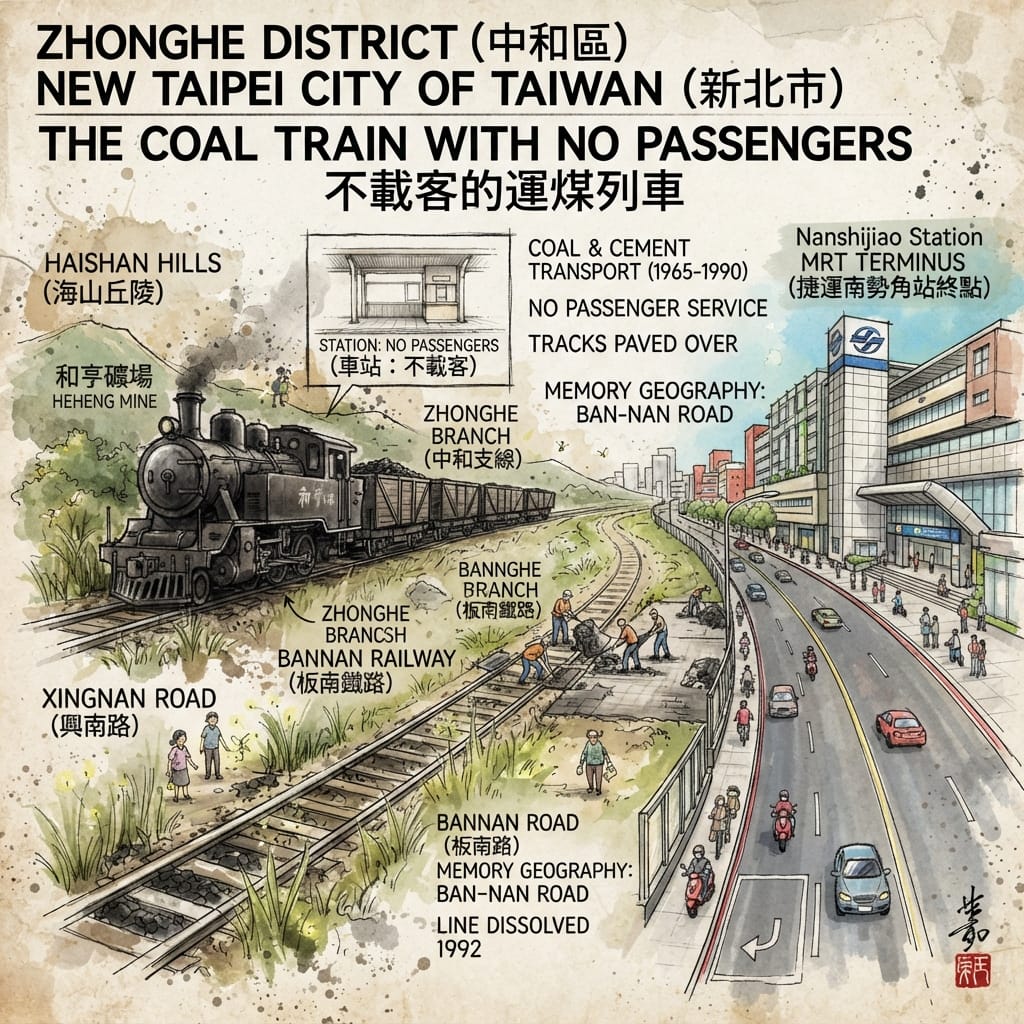
The station is said to have had a waiting room, a platform and a ticket window. It never sold a passenger ticket.
The Zhonghe branch line (中和支線), also called the Bannan Railway, ran about 6.2 kilometres between Banqiao and Nanshijiao. Reports say it was built mainly to carry coal and cement, which is why the station, though fully equipped, took no passengers. The hills of Haishan and Wenshan were early coal country, and Nanshijiao had mines of its own. The Heheng mine (和亨礦場) was opened under Japanese rule; what survives is mostly from a newer shaft sunk in 1975, abandoned now, and dangerous. Earlier still, Fangliao had been a collecting point for Nanshijiao coal. The market of the first story, the one that lost its river, meets coal again here.
I have found no names of the miners, and no account of what happened underground. What can be established is how the line ended. With coal in decline, and with noise, air pollution and traffic conflicts against it, it stopped running in 1990 and was fully taken up in 1992.
The Train With No Passengers
After the rails were lifted the roadbed was paved and became Bannan Road. “Ban” is Banqiao and “nan” is Nanshijiao; the name still records the line’s two ends. Residents disagree about where the freight station stood. Some say on the site of today’s Nanshijiao metro station, others at the nearby Taipower service office. Old maps and aerial photographs could settle it.
Some residents recall walking the dead tracks as children to reach the cinemas in Nanshijiao. Some say there were fireflies in the tall grass near Xingnan Road. Some say they used to jump on the back of the last carriage after school for a short free ride. These are memories posted by local people online and cannot be checked, but they are some of the few pictures of the line with people in them.
A railway built to carry things out of the hills ends where a different line, one that carries people, now begins. Its carriage doors open at Nanshijiao.
Resonance Node: Bannan Road, around Nanshijiao station.
Holographic Sensory Cue: I will not describe the sound or smell of the freight trains; no source records them. The only observable thing is a road that still carries the railway’s name.
5. Huaxin Street (華新街): The Street That Was Named, and the People Who Named Themselves
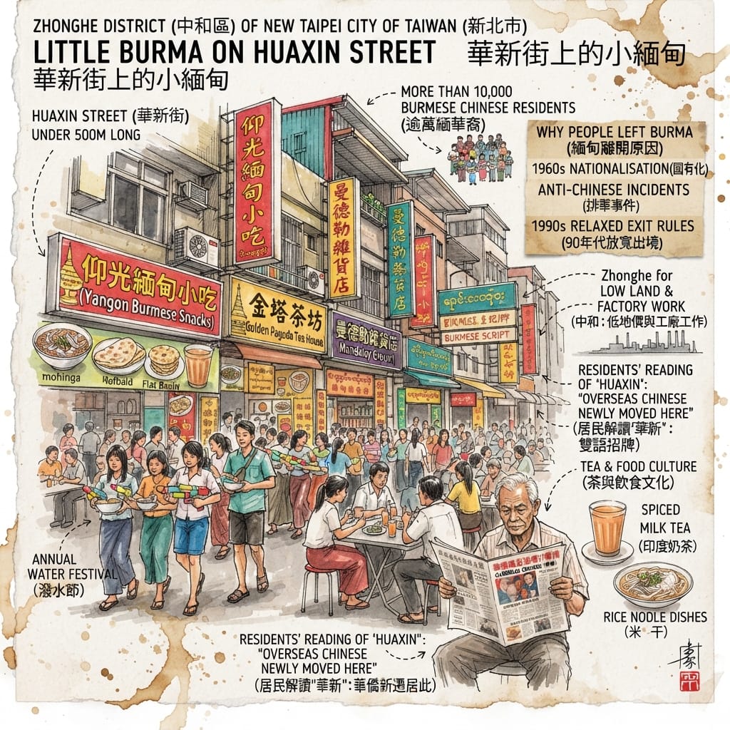
The shop signs are in Chinese and Burmese. Huaxin Street is under five hundred metres long and, according to a recent report, home to more than ten thousand returned Burmese Chinese and their descendants. It is less than ten minutes’ walk from Nanshijiao station. Spiced milk tea, flatbread and rice noodles are what it first offers a visitor.
The name has two readings. Huaxin Village was carved out of Dingnan Village only in 1986, and the official explanation is that the name was chosen as refined, proper language. Residents read it differently: overseas Chinese newly moved here.
The journey behind it is long. From 1954, the families left in Burma by retreating Nationalist soldiers began applying to come to Taiwan. Between 1962 and 1967 General Ne Win’s government nationalised private firms and schools, and in 1964 high-denomination banknotes were demonetised, so that savings lost their value almost overnight. On 26 June 1967 anti-Chinese riots broke out in Rangoon; scholars link them to the foreign policy of Beijing during the Cultural Revolution, and note that the military government also used the crisis to deflect domestic anger. Later waves followed. After the suppression of the 1988 student movement, a woman from Myitkyina in northern Burma arrived in 1989 through a relative who was a Nationalist officer, and later opened a small restaurant on this street. Another woman came as an overseas-Chinese student. In Burma she could hold only an overseas-Chinese card and could not buy property. In Taiwan she could be given an identity card.
The Street Built By The Stateless
Why Zhonghe? Land was cheap, it was close to Taipei, and nearby factories offered work. Nobody chose the place with any ceremony. People simply stopped where the line ended.
What the women say is telling. They kept describing themselves as huaqiao, overseas Chinese, not as Taiwanese. In Burma they were people with an overseas-Chinese card; in Taiwan they are still overseas Chinese. Both Taipei and Beijing have courted such communities in their own ways, and these families moved again, and again, in search of somewhere to settle.
The street does not need to be dressed up. There is a water festival every year. The signs carry two scripts. The smell of the spiced tea is the first thing visitors remember.
Resonance Node: Huaxin Street.
Holographic Sensory Cue: shop signs in both Chinese and Burmese; spiced milk tea, flatbread and rice noodles on the menus.
Zhonghe Today
Walk the five places in order and the district changes shape. The river is a drain. The rails have gone, and a road keeps their name. The mine is abandoned and the kiln is one chimney. The first three stone slabs on the hill are said to sit behind a main hall. What remains is a temple, a road name and a street.
A visitor will mostly see the same: a temple, a road, a chimney, a street. The stories need some paper and some patience to find.
Philosophical Anchor
On Huaxin Street the signs are written in two scripts.
Which line is meant for the people passing and which for the people at home, the signboard does not say.
Accessing the Physical Node
For orientation only; please check opening hours and bus times yourself.
- Start at Nanshijiao station. It is the southern terminus of the Taipei Metro’s Zhonghe line. Bannan Road, the subject of the fourth story, is nearby.
- Huaxin Street: under ten minutes’ walk from the station. It is a living neighbourhood; please treat it as one.
- Hongludi: around Xingnan Road Section 2, Lane 399, reported open round the clock. A travel blog says a tourist minibus runs from Nanshijiao station to the temple; confirm the schedule. The climb is long.
- Fangliao and Guangji Temple: Guangji Temple is on Zhonghe Road, with Fuhe Temple close by. Both are working temples; please observe local etiquette.
- Wayao Ditch and the Haishan chimney: the chimney is on Qiaohe Road Lane 271, near the river, and is a viewing stop only. Wayao Ditch can be seen from Zhonghe Bridge.
- Heheng mine: abandoned and dangerous. Do not enter.
- Route: the district is large and the sites are scattered. Two half-days would work: Nanshijiao, Huaxin Street and Hongludi on one, Fangliao and Wayao Ditch on the other.
💡 Q&A (Frequently Asked Questions)
Q1 | Is the Name "Fangliao" Derived from Guard Huts or Camphor Plank Shelters? The Documented Reality of Pioneer Lin Xiujun and the Decline of the Qing-Dynasty River Port (Fangliao Etymology and Baijie Plain Development History)
A: While popular folklore attributes the name "Fangliao" either to watch-huts built against Plains Indigenous groups or to temporary plank shelters used by camphor workers, surviving historical documentation does not confirm either etymology. Located on the Baijie Plain, Fangliao rose as a bustling commercial and administrative center during the Qianlong era, driven by Zhangzhou pioneer Lin Xiujun (styled Lin Chengzu, 1699–1770), who cleared land and utilized the Xindian River's primary channel for water transport and camphor shipping. However, following the 1786 Lin Shuangwen uprising, the relocation of rival lineage bases to Banqiao, the routing of the longitudinal railway away from Fangliao, and the natural shifting of the Xindian River's course, the port gradually declined into an ordinary thoroughfare.
Q2 | Did the Famous Hongludi Nanshan Fude Temple Really Begin with Three Stone Slabs in the Qianlong Era? The Historical Evolution of Northern Taiwan's Iconic Earth God Shrine (Nanshan Fude Temple Foundation Legend and Religious Geography)
A: Local temple tradition claims that Nanshan Fude Temple—popularly known as Hongludi—was founded in 1736 by Lü Dejin from Zhangzhou's Zhao'an County, who allegedly initiated the shrine with just three stone slabs. However, early historical documentation for this exact founding date is extremely limited, leaving the precise origin shrouded in local lore. Perched on Nanshijiao Mountain at an elevation of 302 meters, the shrine has expanded over centuries of community devotion from a modest rock-sheltered earth god altar into a major northern Taiwan spiritual landmark featuring a towering 31-meter-tall Earth God statue overlooking the Shuanghe basin.
Q3 | How Did Huaxin Street in Zhonghe Evolve into Taiwan's Unique "Burma Street"? The Cold War Geopolitics and Refugee Settlement History Behind the Overseas Chinese Diaspora (Huaxin Street Community Formation and Cold War Migration)
A: The distinctive Southeast Asian cultural landscape of Huaxin Street—widely known as "Burma Street"—originated from the mid-20th-century influx of ethnic Chinese refugees and repatriates fleeing political upheaval and anti-Chinese policies in Burma. Under Taiwan's post-war refugee settlement policies, these displaced communities gravitated toward Zhonghe due to its affordable housing and proximity to the industrial and mining edges of Nanshijiao. Settling along this modest street of under five hundred meters, the diaspora established tea houses and spice shops serving Burmese-Chinese cuisine. Over the decades, Huaxin Street evolved from a migrant refuge into a vibrant cultural enclave and community lifeline within the Taipei metropolitan area.
¿Quieres seguir las rutas históricas que he seleccionado directamente desde tu teléfono mientras caminas? Haz clic para unirte al mapa exclusivo de recorridos históricos en Google titulado "Historical Travel Stories": impórtalo a Google Maps en tu teléfono con un solo toque y deja que te guíe mientras visitas cada lugar histórico en persona.

📖Referencias y lecturas adicionales📖
Fuentes primarias (archivos y materiales históricos oficiales)
- New Taipei Water Resources Department programme on Wayao Ditch, as republished in a Newtalk programme page
- Same department’s account of the ditch’s clean-up, 19 January 2023, in a Newtalk news report
- Zhonghe District Office’s Nanshi Mountain-Ring Trail on the former Second Public Cemetery, in a UDN report
- New Taipei Urban Development Bureau’s Tianshan Camp land release, in a NOWnews report
Materiales de nivel 2 (trabajos académicos)
- NTNU master’s thesis, From Lin Chengzu to Lin Benyuan: Ethnic Relations in Qing-era Banqiao (abstract only, via the UiTM mirror of NDLTD)
- Journal article on Taiwan’s 1920 place-name changes and their phonetic effects (Airiti Library)
- Peng Ni-ni, thesis proposal on first-generation Burmese migrants in Taiwan (Academia Sinica Southeast Asia programme), summarising studies of Zhonghe’s Nanshijiao area
- Huang Yu-han (2009), NTU master’s thesis, Globalization, Transnational Flows and Urban Enclaves: A Study of the Zhonghe Burmese Street Immigrant Community (known only through citation; to be read in full)
- Journal article abstract on the 26 June 1967 anti-Chinese riots in Rangoon (Airiti Library)
- NTU thesis on Revolutionary Council policies and Chinese-Burmese relations, 1962–67
- Taipei education-resource document on Lin Xiujun’s life and tomb in Neihu
Información de nivel 3 (Información complementaria)
- Global Views City, Fangliao Old Street (settlement, camphor, Lin Chengzu, decline)
- Liberty Times, Guangji Temple (about 250 years old at time of writing)
- Money Weekly, Nanshan Fude Temple (history, preserved original shrine, 有土斯有財)
- Money Weekly, a fortune-teller’s profile of the temple (feng shui commentary, used only as modern opinion; contains an inconsistent date)
- People News, on the temple (1739 founding, festivals, lottery anecdote)
- LINE Today, travel feature (tea farmers, Lü and You families, 1952 rebuild, 302 m peak, the 1920 naming of Zhonghe Village)
- UpToGo, on the temple (Lü Dejin of Zhao’an, boulder etymology, 1952 rebuild by You Xingren)
- Mirror Media, vendor’s remark on the temple’s expansion (local belief)
- UDN, the former Zhonghe freight station, quoting a Merit Times report and residents’ memories
- Spectral Codex, Heheng Coal Mine
- Spectral Codex, Haishan Brick Kiln Chimney
- Spectral Codex, Yuantong Temple (with nearby-sites list)
- Spectral Codex, Zhanghe Public School campus shrine
- The News Lens (Taipei Walking Tour), Wayao Ditch, springs and the Eight Views
- CommonWealth, Wayao Ditch event page (name from kilns; boundary river)
- Liberty Times, the ditch’s transport past and pollution
- Storm Media, the blue wastewater incident and fine
- CNA book excerpt (Hsu Hsiang-pi, Nobodies in Taiwan History), Huaxin Street naming and interviews
- UDN (2026), Huaxin Street as Taiwan’s largest “Burma Street” (only the summary line was read)
- The News Lens, Burma’s 1960s nationalisation, schooling and demonetisation
- CommonWealth Smile Taiwan, Huaxin Street and why migrants settled in Zhonghe
- New Taipei City tourism, diary entry on bilingual shop signs
- Japanese-language wiki mirror, Zhonghe District (older community names; 1920, 1946, 1958, 1978 administrative history; verify before use)
- Blog on Zhanghe Wetland (popular claim on the origin of the name Zhanghe; low reliability)
- The News Lens, family-history essay noting the Japanese-era term Ketagalan
- English Wikipedia, Zhonghe District (district-wide Burmese Chinese estimate)
 Lawrence
 Lawrence
 Lawrence
 Lawrence