Kowloon's Sze Shun: Seven Centuries of Adversity Beneath Four Characters for Good Fortune
Four estates. Four names meaning smooth. Beneath them: a Song Dynasty salt empire, a colonial graveyard, WWII burials, six thousand people living among bleached bones — and a naming that tried to cover all of it.

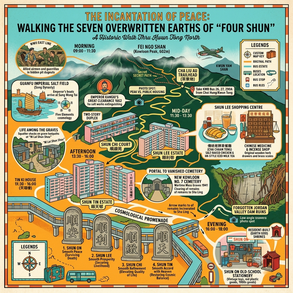
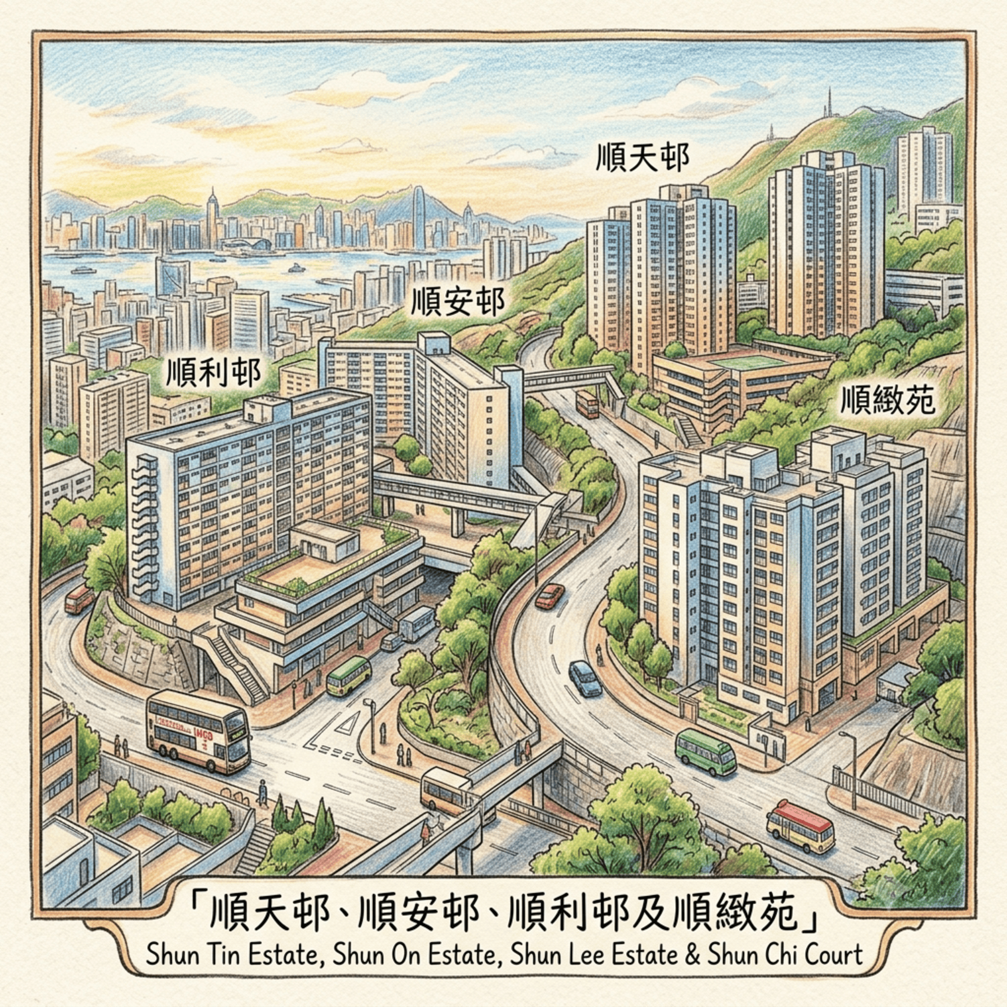
This article has special meaning for me – I have lived in Shun Tin Estate for more than 10 years since my high school days.
 Lawrence
This is a historical travel essay about Hong Kong's Sze Shun district — four public housing estates in Kwun Tong whose names all begin with the Cantonese character 順, meaning smooth or favorable. Beneath them lie seven distinct historical layers: a Song Dynasty imperial salt field, a colonial-era graveyard that became a WWII burial site, a community of six thousand people forced to live among the exhumed dead, a wartime guerrilla escape corridor, and — finally — an act of naming that attempted to correct, in the Taoist tradition of cosmological inscription, everything the ground had suffered. This piece follows those layers down.
The Ground Beneath the Names
The four names climb the hillside in the sequence the housing authority gave them: Shun Lee, Shun On, Shun Chi, Shun Tin. They translate, roughly, as Smooth Prosperity, Smooth Peace, Smooth Refinement, Following Heaven's Way. Four estates, four expressions of the same aspiration, all beginning with the same character — 順 — smooth, favorable, flowing with the current rather than against it.
The ground beneath them does not answer to any of these names.
Most cities are built on the erasure of earlier cities; this is the first principle of urban archaeology and the subject, at one depth or another, of almost every serious piece of writing about place. But Sze Shun — the informal collective name for these four estates in eastern Kowloon — offers a concentration of historical layering that is unusual even by the compressed standards of Hong Kong, where eight hundred years of recorded human activity has been flattened, literally and figuratively, into a peninsula roughly the size of Manhattan.
Beneath the concrete of these estates, in descending order of recency: the demolished shacks of six thousand people who had no other options; below that, the bones of a wartime generation hastily interred during Japan's occupation; below that, the formal infrastructure of a colonial cemetery established in 1935; and below that, the residue of a Song Dynasty imperial salt field that made this coastline, for centuries, one of the most economically productive stretches of shoreline in southern China.
Four characters for smooth sailing. Seven centuries of troubled water.
What follows is an attempt to read those layers — not as a tour guide's curiosity but as a serious account of what cities bury and why, and of what happens when a society, consciously or not, reaches for the vocabulary of a cosmological tradition to name over what it cannot bring itself to properly mourn.
Listen to the historical stories told in detail (For subscribers only)
The First Layer: A Salt Empire the Size of an Imperial Economy
Hong Kong does not easily yield its Song Dynasty past. The tourist infrastructure points you to the Peak Tram, the night markets, the harbour skyline. But the name Kwun Tong — the district that surrounds Sze Shun — is itself a compressed archive of something far older.
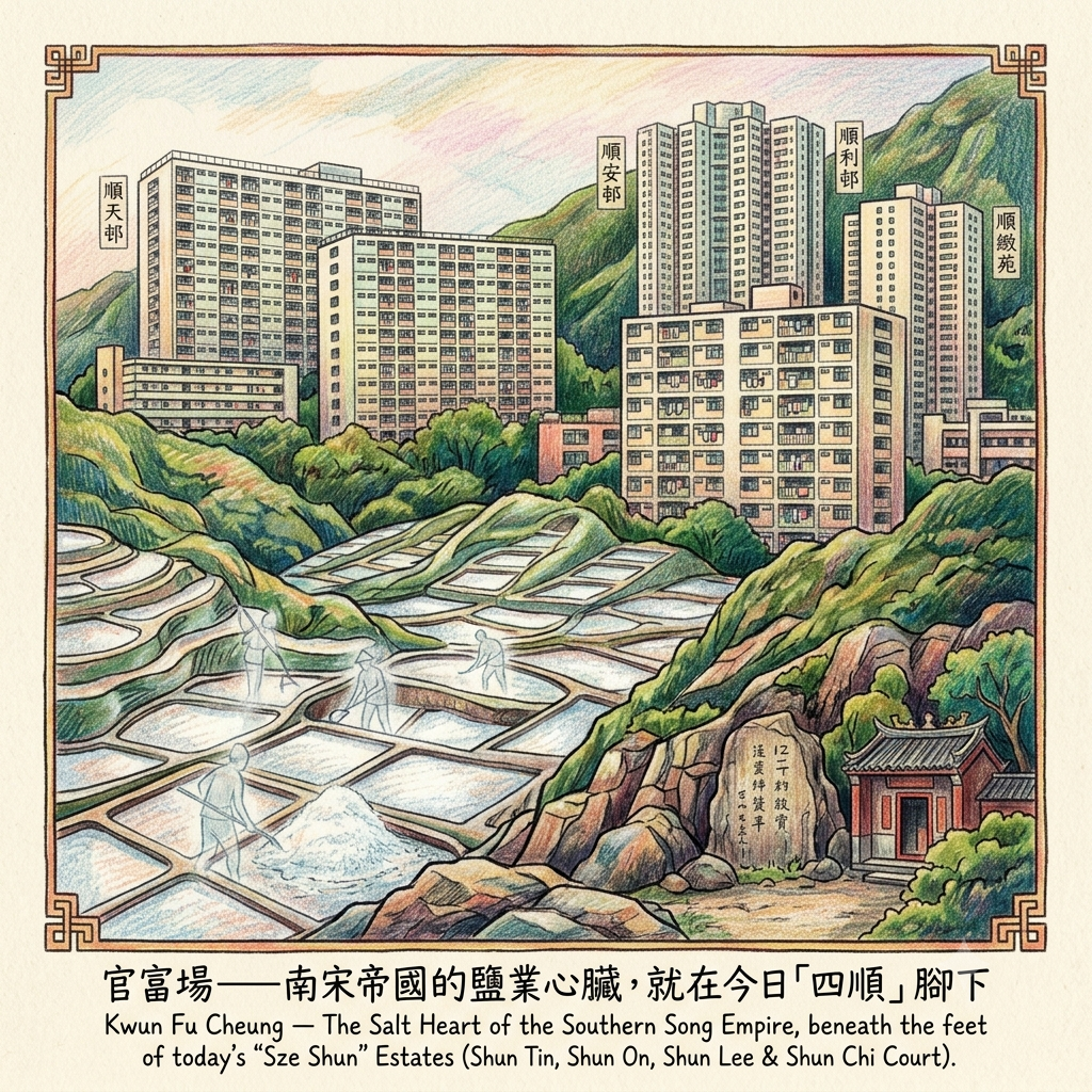
The full historical name of this coastline was Kwun Fu Cheung: 官富場, the Government Prosperity Field. Established during the Northern Song Dynasty as an official salt-production zone administered directly by the imperial court, it was one of four major salt fields in Dongguan County and, by the Ming period, one of the most productive in all of Xin'an — the county that then encompassed today's Hong Kong and Shenzhen. Its output supplied coastal communities across Guangdong and was exported as far as Guangxi province.
The imperial salt monopoly is one of the great, under-appreciated engines of Chinese history. For more than two thousand years, from the Han Dynasty onward, the state's control of salt production was as fundamental to Chinese governance as the control of taxation or territory. Salt officials were senior appointments. Salt revenues funded armies. The administration of salt fields like Kwun Fu Cheung was not a minor economic matter; it was an act of imperial sovereignty over the landscape itself.
For a moment at the end of the thirteenth century, that sovereignty was made painfully personal. When Mongol forces drove the final Song rulers southward in 1278 and 1279, the fleeing court passed through this coastline. The child emperor Bing — the dynasty's last — and his attendants paused, tradition records, on a flat rock at the edge of the salt field. Later generations gave that stone a name: the Song Wong Toi, the Terrace of the Song Kings. The dynasty collapsed at sea shortly afterward, the imperial fleet destroyed off Lantau. The salt field outlived its founders.
The Ruined Salt Empire Under Kwun Tong
What ended the salt civilisation was not conquest but a decree. In 1662, the Kangxi Emperor — anxious about coastal resistance to Qing authority — issued the Coastal Evacuation Order (Qianjieling), forcing the removal of all inhabitants from a deep strip of coastline across southeast China. The salt workers of Kwun Fu Cheung departed. No one who knew the craft returned. The great salt field became, over the following decades, simply a bay — its name contracted first to Kwun Tong (Government Pond, a reference to the flooded salt pans that resembled common pools), then, because later residents disliked the word for "official," shifted to the near-homophone Kwun Tong (Viewing Pond). The empire was erased even from the name used to mourn it.
Of the entire Kwun Fu Cheung civilisation, one object survives in the physical world. In 1274 — a year before the Song Dynasty's final collapse — a salt official named Yan Yizhang visited the Tin Hau temple at Fat Tong Mun (today's Joss House Bay in Sai Kung) and carved an inscription into the rock beside it. It is the oldest dated stone inscription in Hong Kong. It stands at the edge of the South China Sea, weathered but legible, quietly recording a world that vanished three hundred and fifty years before Hong Kong became a British colony.
Reading the Salt Empire Through the Taoist Five Elements
The cosmological tradition that underpins Chinese architecture, urban planning, and landscape reading — feng shui, rooted in Taoist philosophy — does not view geography as passive terrain. It understands the landscape as a system of elemental energies in dynamic relationship: Wood, Fire, Earth, Metal, Water, cycling through generation and depletion in patterns that have specific consequences for the human communities that inhabit any given place.
Salt, in this framework, is the crystallised residue of Water — the ocean's energy rendered into its most concentrated mineral form. A coastline of salt pans is understood as a Water-to-Metal transformation zone: the sea's fluid vital energy (qi) being refined into solid, exportable matter. The imperial administrators who established the Government Prosperity Field were positioning themselves — intentionally or not — within a geography already designated by its own elemental grammar as a site of refined productivity.
The Kangxi Evacuation Order of 1662 did not merely displace a workforce. In the Taoist reading, it severed the human mediation of an elemental process that had been running for centuries. The coastline's Water energy, no longer channelled through the technology and knowledge of the salt workers, became undirected, uncollected, dissipated. What followed was not prosperity but vacancy.
The next layer to occupy the ground was not a salt field. It was a place for the dead.
Holographic Sensory Cue: Fat Tong Mun, Sai Kung. A morning in February, the South China Sea flat and silver in the early light. The Tin Hau temple sits at the tideline, its incense smoke thinning in the offshore breeze. Yan Yizhang's inscription is set into the cliff face to one side — the characters shallow from seven centuries of weathering, still readable if you know what to look for. This is the last physical object that connects the Sze Shun ground to its Song Dynasty past. Everything else — the salt pans, the salt workers, the empire itself — exists now only in the name of a bus stop.
The Second Layer: Cemetery No. 7 and the Winter of 1941
Advance the calendar six hundred and seventy years.
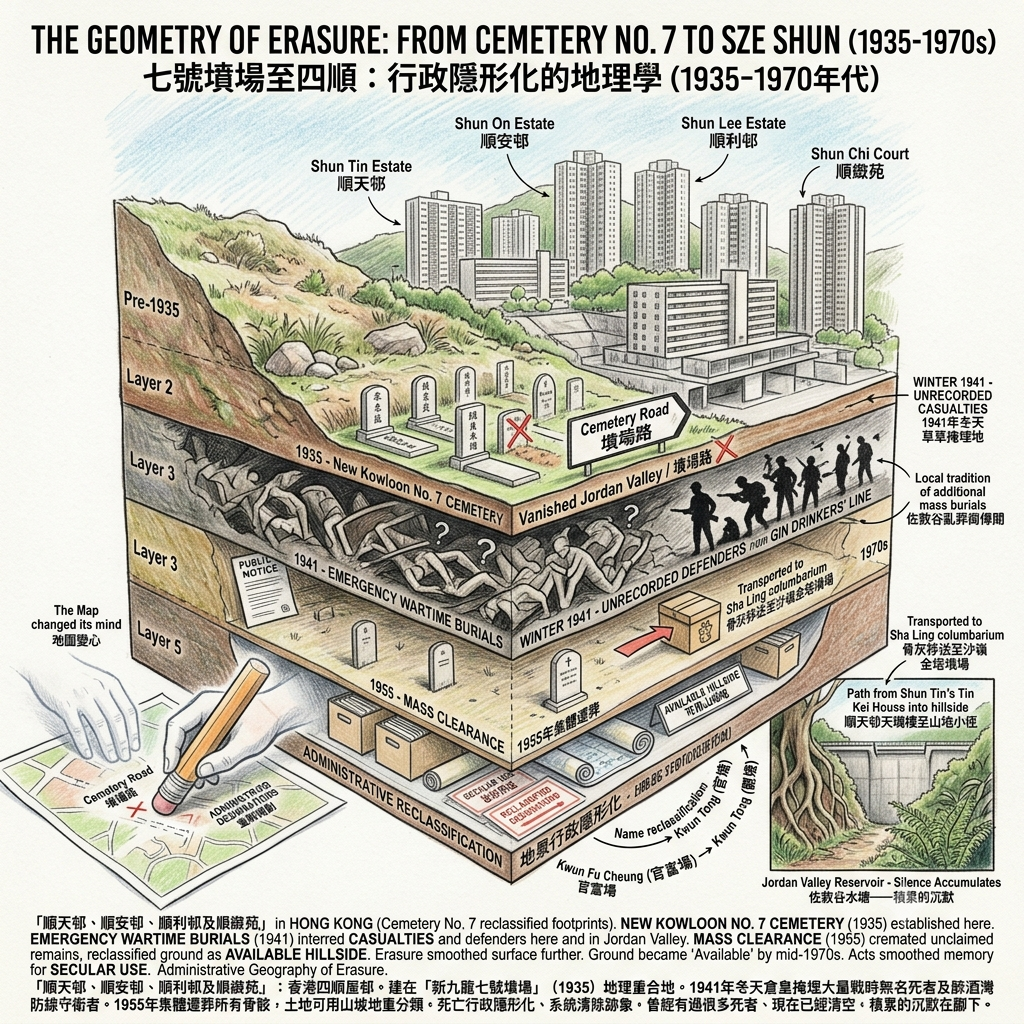
In 1935, the colonial government of Hong Kong surveyed the hillside above what would become the Kwun Tong industrial zone and identified it for a purpose that growing cities always require: a new public cemetery. Cemetery No. 7 — New Kowloon No. 7 Cemetery — was established on slopes whose position corresponds precisely, as postwar aerial photography confirms, to the footprint of today's Shun Lee, Shun On, and Shun Tin estates.
The cemetery served its intended function for six years.
On December 8, 1941, Japanese Imperial forces attacked Hong Kong simultaneously with Pearl Harbor. The colony's defenders — British regulars, Indian infantry, and two Canadian volunteer battalions, the Royal Rifles of Canada and the Winnipeg Grenadiers, newly arrived and barely trained — held the Gin Drinkers' Line across the Kowloon hills for less than two days. By December 13, Kowloon was in Japanese hands. By Christmas Day, the colony had surrendered.
The killing was not quick and it was not clean. Large numbers of civilians and soldiers were killed in the urban districts of Kowloon during the days of fighting and in the immediate aftermath of occupation. Their bodies required disposal. Cemetery No. 7, positioned on the hillside above the occupied city, became an emergency burial site. Contemporary accounts describe bodies being hastily interred in ground already designated for the dead. The number of those buried, and their identities, are not consistently recorded in any surviving document.
In the adjacent Jordan Valley — the Jowdaan Guk that sits immediately behind today's Shun Tin Estate — local accounts speak of additional wartime burials, possibly on a larger scale. The evidence for this is difficult to evaluate: the oral tradition is persistent, but the documentation is thin. What is not thin is the cartographic evidence. Road maps of Kwun Tong from the 1960s show, in the area that would become Jordan Valley Park, a named thoroughfare: Cemetery Road. That designation does not appear on any subsequent revision of the map. It was present. Then it was not.
The official disposal of Cemetery No. 7 came in 1955, when the colonial government issued a public notice requiring all families to remove their relatives' remains before year's end. Those that remained unclaimed — and after occupation, displacement, and the deaths of relatives across the territory, there were many — were collected, cremated, and transported by administrative arrangement to a columbarium at Sha Ling in the rural New Territories.
The ground was cleared. On the planning documents, it was reclassified as available hillside. The paper trail grew thin. The map changed its mind about Cemetery Road. The bones moved to Sha Ling, filed under some administrative category that did not require further public acknowledgement.
The Mass Grave Beneath the Concrete
The Administrative Geometry of Erasure
There is a specific grammar to the way cities manage inconvenient death. It involves the movement of remains from one location to another, the renaming of roads that carry uncomfortable associations, the reclassification of land from its previous designation to something more useful, and the filing of documentation in archives that are accessible in principle but consulted in practice by almost nobody. This is not a conspiracy; it is standard urban procedure. Cities that stopped to fully account for every layer of violence, displacement, and death they contained would never get around to becoming cities.
What is specific to Sze Shun is the density of the procedure. In a relatively short period, the same patch of hillside absorbed: formal civilian burial, wartime emergency interment, the possible concentration of occupation-era casualties nearby, official mass exhumation, administrative reinterment at a distance, and the erasure of a road name. Each act smoothed the surface further. By the time the first construction crews broke ground on the Shun Lee development in the mid-1970s, the hillside was, on paper, simply: available.
Holographic Sensory Cue: The path from Shun Tin Estate's Tin Kei House into the hillside above Jordan Valley Park. The vegetation closes over the trail within fifty metres. At the end of a short climb, a concrete dam wall, half-hidden by ficus roots and maidenhair fern: the remains of the Jordan Valley Reservoir, built around 1960, closed in the 1980s, now filling slowly with leaf litter. The air is cooler here than on the estate below. Nothing marks what the valley held before the reservoir was built, or what the 1960s maps called the road that ran through it. The silence is the kind that accumulates rather than the kind that simply exists.
The Third Layer: Six Thousand People, Bleached Bones, and the Language of Acceptance
When Cemetery No. 7's bones were cleared in 1955, the hillside was put to the only use that seemed appropriate for ground this marginal: it was designated as a reception area for Hong Kong's most marginal people.
The colony's postwar housing crisis was severe and persistent. The population had swelled with refugees from the mainland; the Shek Kip Mei fire of 1953 had destroyed the homes of fifty thousand squatters in a single night and galvanised the public housing programme. But the programme had rules. To qualify for resettlement in one of the new estates, a family needed to be documented, to have registered in their existing illegal structure before a specified date, to satisfy a bureaucratic checklist that many of the colony's poorest residents — people who had arrived recently, or worked in informal economies, or simply had not understood the registration requirements — could not meet.
For these families, the cleared slopes of Cemetery No. 7 became an alternative. Beginning in the mid-1950s, waves of displaced households from across the peninsula were relocated to the former hillside burial ground — sometimes with advance warning, sometimes without. They came from squatter settlements in Homantin and Tai Hang Tung, from informal housing in Shamshuipo, from areas cleared for industrial development or other estates. They were told where to go. Most went.
The conditions were, by any measure, difficult. Water supply was unreliable. There were no legal taxi routes; illegal white-plate cars charged what the market would bear. Employment in the area was scarce. By September 1963, the population on these slopes had reached an estimated six thousand.
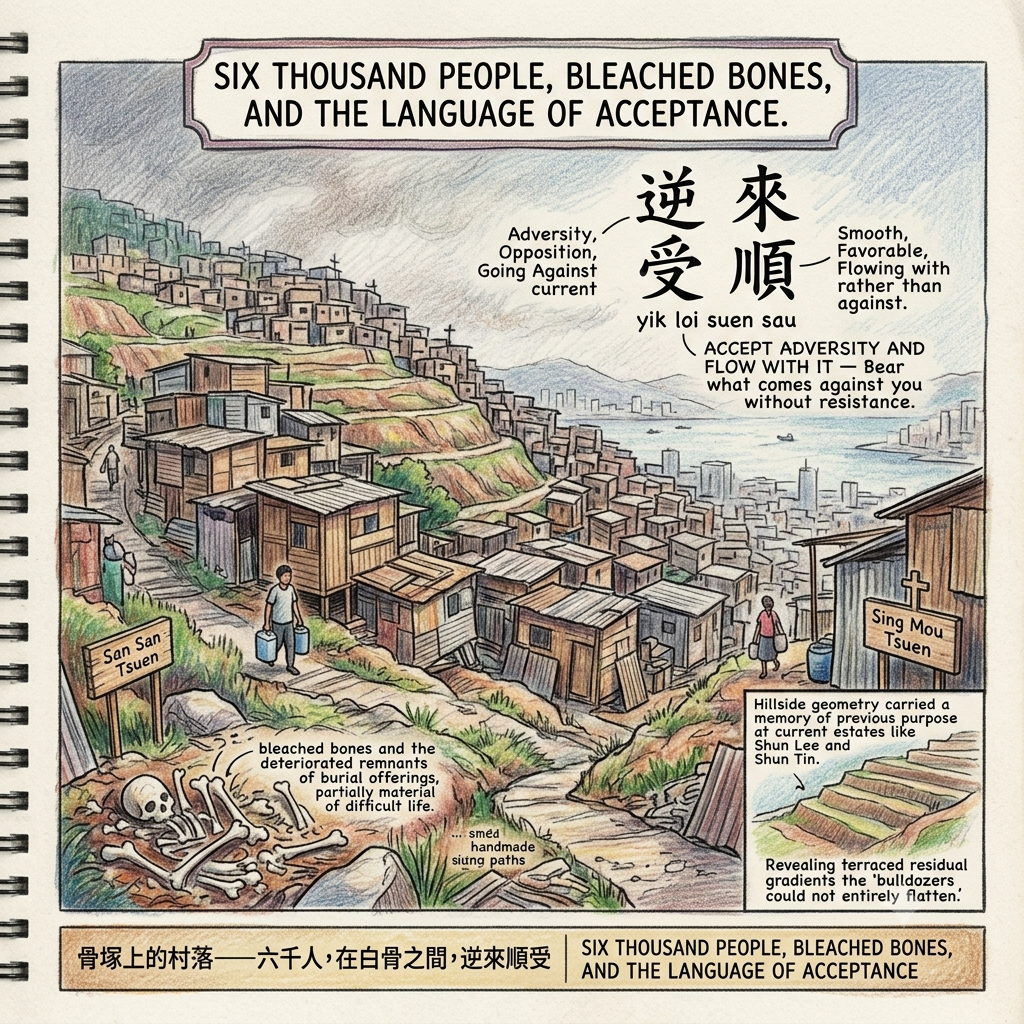
And in the first years of settlement — as the written record plainly states — the residents encountered, at no great distance from the paths they were building their homes along, the material residue of the cemetery that had preceded them: bleached bones and the deteriorated remnants of burial offerings.
The official clearance of 1955 had moved what it found. It had not found everything.
The phrase that appears in contemporary accounts to describe the psychological condition of these settlers is a Cantonese idiom of considerable philosophical density: 逆來順受 — yik loi suen sau. There is no clean English equivalent. The closest rendering is something like accept adversity and flow with it — bear what comes against you without resistance, redirect its force rather than meeting it head-on. It is the vocabulary of people who have calculated, correctly, that they cannot change their situation and must absorb it instead.
The Village of Bleached Bones
The phrase is made of four characters. The second character — 逆, yik — means adversity, opposition, going against the current. The fourth character — 順, suen — means smooth, favorable, flowing with rather than against. The settlers described their own psychological condition using an idiom that held, in careful suspension, both the reality of their adversity and the aspiration toward its eventual resolution.
Within this language of resigned endurance, however, there ran a countercurrent of determined self-naming. The settlers organised their community along the old paths of the former cemetery — the tracks that had once connected burial plots — and gave their neighbourhoods the forward-looking names that people in difficult circumstances reliably reach for. San San Tsuen: New-New Village. Wo Ping Tsuen: Peace Village. Sing Mou Tsuen: Holy Mother Village, where a Catholic mission had established a presence. San Kwun Tsuen: New View Village. Every name faced deliberately away from what the ground had been.
In 1966, the colonial government began dismantling the largest settlements, relocating most residents to newly completed blocks in Lam Tin. But a significant minority — families whose documentation did not satisfy the housing authority's standards — were refused resettlement. They were instructed to vacate. They negotiated. They clashed with demolition crews. The historical record of what became of them afterward is, like so much of this story, thin.
Resonance Node: The Slope Geometry of Shun Lee and Shun Tin
The hillside geometry around Shun Lee and Shun Tin estates was never fully erased by the 1970s construction. Walk the outer edges of either estate in the late afternoon and the ground reveals itself: the terraced contours, the residual angles of the slope that the bulldozers could not entirely flatten, the places where the gradient seems to carry a memory of previous purpose. The idiom 逆來順受 — accept adversity and flow with it — is stored here not as text but as topography. The hill remembers the paths that the cemetery and the settlement built across it, even when the maps no longer show them.
The Fourth Layer: The Ridge Above, and the People Who Crossed It
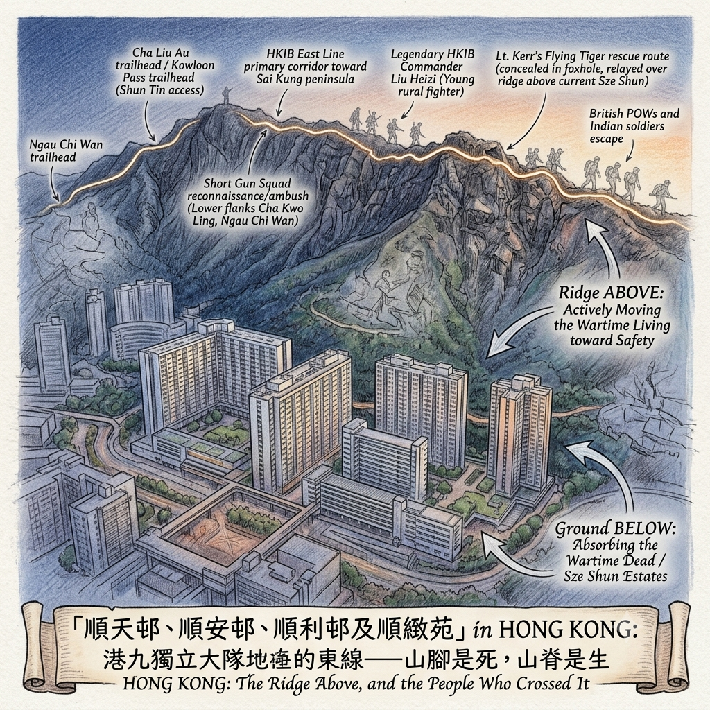
While the dead lay in the ground below, the living moved across the ridge above.
On February 3, 1942 — less than six weeks after the colony's surrender — a small group of activists, operating under the direction of the Chinese Communist Party's Guangdong organisation, formally constituted the East River Column's Hong Kong and Kowloon Independent Brigade at a chapel in the rural village of Hueng Mo Ying, Sai Kung. Known in English as the HKIB, and in Cantonese as Gong Gau Duhk Laap Daai Deui, the brigade would become the only organised armed resistance force to operate continuously throughout Hong Kong's three years and eight months of Japanese occupation. It was also, by the end of the war, the only such force to receive formal expressions of gratitude from both the President of the United States and the British Crown.
Their operational area encompassed the hills immediately above the Sze Shun ground. Their most important strategic artery ran directly across the terrain that those hills contain.
The East Line was the brigade's primary escape and resupply corridor. It ran from the occupied urban districts of Kowloon northeast through Ngau Chi Wan, over the ridge of Kowloon Pass, and down into the Sai Kung peninsula — where boats could cross Mirs Bay to guerrilla bases on the mainland. The slopes immediately behind what is now Sze Shun formed a staging ground for this transit. Partisan units under the Short Gun Squad — led by the legendary Liu Heizi, a young rural fighter who became one of the brigade's most effective field commanders — conducted reconnaissance operations and ambushes in the adjacent neighbourhoods of Cha Kwo Ling and Ngau Chi Wan, the territory that borders Sze Shun on its lower flanks.
The Ridge Of Life And Death
The brigade's rescue operations extended beyond Chinese civilians and combatants. Through the East Line, the HKIB moved escaped British prisoners of war from the camps at Sham Shui Po and Argyle Street, Indian soldiers who had separated from their units, and, in one episode that illustrates the brigade's reach, several American airmen of the Flying Tigers — the volunteer air group that flew under Chinese Air Force colours in support of the Allied campaign.
The most cinematic of these rescues involved a pilot known in the historical record as Lieutenant Kerr. Shot down while bombing Kai Tak Airport in 1944 — the brigade itself had conducted a ground raid on the airport that year, destroying a Japanese aircraft — Kerr parachuted onto the slopes near Sha Tin Pass, where Japanese forces immediately began to converge. HKIB scouts concealed him in a foxhole, then moved him through a relay of safe houses and mountain trails, following a route that traced the high ground directly above what is now Sze Shun, before eventually evacuating him by fishing boat from the Sai Kung coast to the mainland. He survived. His story reached Washington. The commendations followed.
The spatial arithmetic of this history has a quality that resists casual description. In the same geological mass — the southern flank of Kowloon Peak — during overlapping historical periods, the ground below was absorbing the wartime dead while the ridge above was actively moving the wartime living toward safety. The cemetery and the escape route occupied different elevations of the same mountain. Most people who live in Sze Shun today, and most of the people who take the Kowloon Peak trail from the trailhead near Shun Tin Estate, are unaware that the path they walk on was, in 1944, one of the more consequential pieces of terrain in this part of the Pacific theatre.
Holographic Sensory Cue: The Cha Liu Au trailhead, near Shun Tin Estate, in the hour before dawn. The air carries the particular dampness of a Hong Kong hillside at night — not quite rain, more a pervasive moisture that condenses on everything. The estates below are still mostly dark; a few windows lit on the upper floors. The trail rises into the dark above. What happened here in December 1941 and what moved across this ridge between 1942 and 1945 are both, at this hour, equally invisible. The mountain does not commemorate. It only holds.
The Fifth Layer — and the First: The Four Characters, and What They Were Correcting
In 1972, the colonial Resettlement Department set out the formal planning case for major public housing development on the former cemetery ground. The proposal described the site's location clearly, using language that appears in the official documents without apparent irony: the development would be built on the cleared site of New Kowloon Cemetery No. 7 and unorganised burial ground.
The phrase "unorganised burial ground" is administrative Cantonese for what a less restrained vocabulary might call a mass grave site. The planners knew what they were building on. They proceeded.
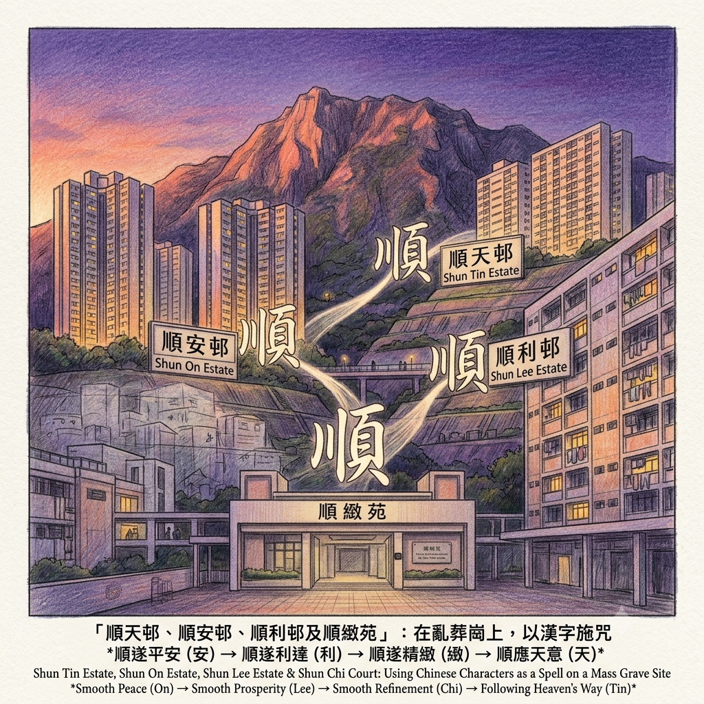
The Hong Kong Housing Authority — which took over responsibility for the project — eventually divided the development into four distinct estates, each managed separately. Each was given a name beginning with the same character. The selection was, as is conventional in such exercises, intentional: in the naming of Hong Kong's public housing clusters, related estates in the same district routinely share an initial character, both for administrative clarity and for the auspicious resonance that the character carries. The character chosen for this cluster was 順.
- Shun Lee Estate (順利邨), completed 1978 — Smooth Prosperity
- Shun On Estate (順安邨), completed 1978 — Smooth Peace
- Shun Chi Court (順緻苑), completed 1979–80 — Smooth Refinement
- Shun Tin Estate (順天邨), completed 1981 — Following Heaven's Way
Shun Chi Court carries a distinction that is not widely known: it was the first estate completed under Hong Kong's Home Ownership Scheme — the programme, launched under Governor Murray MacLehose's ambitious ten-year housing plan, that made it possible for middle-income Hong Kong residents to purchase, rather than rent, their public housing flats. The aspiration to own the place where you live, as distinct from merely occupying it on a government lease — one of the defining social aspirations of postwar Hong Kong — was first realised as official policy at this address, on this hill, on this ground.
The first act of homeownership in the history of Hong Kong's HOS programme took place on top of Cemetery No. 7.
A Taoist Reading of the Names
The Taoist philosophical tradition — which underlies Chinese cosmological thinking as thoroughly as the Enlightenment tradition underlies the English intellectual world — takes a specific position on the act of naming. Names are not arbitrary labels. They are inscriptions: acts of declaring what a thing is in the scheme of things, and thereby participating in the shaping of its fate. The Tao Te Ching opens with the most famous paradox in Chinese philosophy — the Tao that can be named is not the eternal Tao — but the tradition that grew from it understood naming as a form of cosmological positioning. To give a place a name is to begin reshaping its energetic reality.
How Hong Kong Overwrote a Traumatic Geography
The character 順 carries, in the Taoist philosophical vocabulary, a weight that its English translation — "smooth," "favorable" — cannot quite convey. Beyond the everyday meaning of flowing without obstruction, 順 encodes a fundamental cosmological principle: acting in alignment with the way things naturally flow, rather than imposing force against the current. The Tao Te Ching's eighty-first chapter states that heaven's way benefits and does not harm; the sage's way acts without contending. The essence of both is 順 — yielding, flowing, aligned with the natural order. To name something 順 is to declare it in correspondence with heaven's grammar.
Now consider what was being named. Against the accumulated weight of this hillside — the salt empire destroyed by imperial decree in 1662, the formal cemetery established in 1935, the wartime burials of 1941, the official exhumation and administrative relocation of unclaimed bones in 1955, the forced settlement of six thousand people among residual bone and burial goods, the subsequent forced removal of those who could not satisfy documentation requirements — the housing authority placed four repetitions of the character for smooth flowing and alignment with heaven.
Four acts of cosmological inscription, on ground that had known very little of either.
This is where the linguistic archaeology of Sze Shun becomes precise in a way that cannot be easily dismissed as coincidence. The settlers who were forced onto this hillside in the 1950s described their psychological condition — in the accounts that contemporary observers recorded — using the Cantonese idiom yik loi suen sau: 逆來順受, accept adversity and flow with it. The idiom contains, embedded in its four characters, both the word for adversity (逆, yik) and the word for smooth flowing (順, suen). The settlers' own vocabulary for their suffering held, in suspension, the word that would eventually become their address.
Whether the Housing Authority's naming committee was aware of this linguistic recursion is, in the absence of any surviving committee minutes, impossible to determine. The cosmological resonance may have been entirely unconscious. But in the Taoist framework, the distinction between intentional and unconscious naming is less significant than the inscription itself. The character 順 was placed four times on a hillside where it had been needed, by almost any reckoning, for a very long time.
Resonance Node: The Entrance to Shun Chi Court
Shun Chi Court's entrance, at dusk, with Kowloon Peak catching the last of the western light above it. The architecture here is slightly more deliberate than the adjacent public rental blocks — the Housing Authority was conscious, in 1979, that this was a new kind of offering, a different social contract. Families who bought their flats here were not renters. They were owners. The first ones in Hong Kong's history to do so under official policy. They were also standing, though none of the promotional materials mentioned it, on the cleared and renamed site of New Kowloon Cemetery No. 7. The light on the mountain above is, at this hour, the same light it has always been. The aspirations on the nameplate are new.
The Weight of the Smooth
All cities are, in some sense, palimpsests — the medieval term for a manuscript page from which the original text was scraped to allow reuse, but from which the old writing bleeds through regardless, faintly visible beneath the new. London's roads follow the lines of Roman roads. Paris's boulevards were cut through medieval street patterns by Haussmann's demolition crews. New York's grid ignores the Indigenous trails it overlaid, except where Broadway follows the old path of the Wiechquaeskeck trail because the colonists found it easier to walk an existing route than to cut a new one.
Hong Kong offers this experience at higher speed and higher density than most. In a territory where usable flat land was always scarce and population pressure was always extreme, the layers were never given time to settle before the next layer arrived. A salt field becomes a bay; a bay becomes an industrial waterfront; a hillside above the waterfront becomes a cemetery; the cemetery becomes a forced-settlement zone; the settlement becomes a public housing estate. Each transition overwrites what came before, and each naming — Government Prosperity Field, Cemetery No. 7, New-New Village, Shun Lee Estate — declares the new identity as if it had always been there.
What is singular about Sze Shun, in this context, is that the final naming — the four 順 characters — carries within it the tradition's own acknowledgement that naming is a corrective act. In the Taoist framework, you do not name something 順 because it already flows smoothly. You name it 順 because you are asserting, against the evidence of what the ground has been, that it can and should flow smoothly henceforth. The name is not a description. It is a declaration, addressed to the landscape itself.
This is a more honest act than it appears. The salt empire, the colonial graveyard, the wartime burials, the six thousand people who absorbed adversity and called it 逆來順受, the guerrillas who used the ridge as a lifeline, the first Hong Kong homeowners who unknowingly planted their aspirations in former burial ground — all of them contributed to a landscape that is, by the standards of most places on earth, extraordinarily freighted with accumulated human experience.
Naming it Smooth does not erase that. Nothing erases that. But in the tradition the name draws on, naming it Smooth is the first step in acknowledging that the ground has suffered enough, and that what it deserves now is a different fate.
The great historian of memory, Paul Connerton, observed that what societies choose not to forget and what they choose to forget are equally constitutive of identity. Sze Shun has been asked to forget a great deal. The salt official's inscription at Fat Tong Mun is still legible because the stone is harder than the institution's memory. The bones were moved to Sha Ling, but the Sha Ling records are not prominently displayed. The Short Gun Squad's operational maps are in archives that most of the area's residents have never heard of.
What remains is the name. Four times, on four hillside estates, the character for smooth flowing and alignment with heaven. Written over seven centuries of its absence.
If this piece has changed the way you read the ground beneath a city — subscribe to our newsletter. Each issue takes a place that appears unremarkable and reads it until it isn't.
Reaching the Ground: How to Visit Sze Shun
Getting There
Sze Shun sits in the northern section of Kwun Tong District, on the lower flanks of Kowloon Peak (海拔602米), approximately fifteen to twenty-five minutes by bus from Kwun Tong MTR station (Kwun Tong Line):
- KMB Route 23: Kwun Tong Ferry Pier ↔ Shun Lee Estate
- KMB Route 26: Shun Tin Estate ↔ Tsim Sha Tsui East
- KMB Route 27: Shun Tin Estate ↔ Mong Kok
- Green minibuses run frequently from Choi Hung and Ngau Tau Kok MTR stations
A Suggested Sequence for Reading the Layers
Early morning — Begin at the Cha Liu Au trailhead for the Kowloon Peak Country Trail, located near Shun Tin Estate. Walk twenty minutes uphill to the first clear overlook. From here the spatial arithmetic of the fourth layer becomes visible: the ridge behind you is the East Line corridor; the estates below are the Cemetery No. 7 footprint; the South China Sea, on clear days, marks the direction of the sailing boats that carried escaping guerrillas toward the mainland in 1942–45.
Mid-morning — Walk the perimeter paths of Shun Lee and Shun On estates. The terraced hillside geometry — sections of slope that the construction of the 1970s could not fully rationalise — preserves the contour memory of the cemetery. The estate architecture here is among the oldest public housing still standing in Kowloon: cross-shaped and I-shaped tower blocks from the early Housing Authority era. These buildings are unremarkable. That is precisely the condition that requires the most attention.
Afternoon — Find the footpath near Tin Kei House, Shun Tin Estate, that rises into the hillside above Jordan Valley Park. Follow it to where the trail ends at a concrete dam wall, slowly being reclaimed by the surrounding vegetation: the remains of the Jordan Valley Reservoir, built around 1960 to supply the settlement's residents with water, closed in the 1980s, never demolished. This structure is the most accessible physical connection to the pre-estate landscape. Cemetery Road, which the 1960s maps showed running near this valley, is nowhere marked. That is also information.
Late afternoon — End at Shun Chi Court's entrance. Hong Kong's first Home Ownership Scheme court. Read the nameplate. Consider what it means that this particular ground was chosen as the site for that particular first.
Three Sites for Close Attention
① The Jordan Valley Reservoir dam remnant (near Tin Kei House, Shun Tin Estate): the most physically immediate connection to the pre-housing landscape, and the nearest accessible point to the Jordan Valley ground that Cemetery Road once named.
② Shun Chi Court entrance (순緻苑): where the aspiration to own your home in Hong Kong was first given official form, on cleared cemetery ground, in 1979. The architecture and the nameplate, taken together, are the densest single point in the Sze Shun palimpsest.
③ The Kowloon Peak ridgeline from the Cha Liu Au trail: where, on a clear morning, you can see simultaneously the estates below (the 1970s–80s layer), the ridge above (the 1941–45 layer), and, faintly, the outline of the Kowloon hills that once constituted the Song Dynasty's nine dragon veins. No marker connects these views. The connection is structural and does not require a sign.
Essential Extension: The Salt Official's Inscription
Yan Yizhang's 1274 inscription — the oldest dated stone inscription in Hong Kong, carved by a Song Dynasty salt official whose administrative territory included the Sze Shun ground — stands at the Tin Hau temple at Fat Tong Mun (Joss House Bay), Sai Kung. From Sze Shun, the journey takes approximately thirty to forty minutes by bus via Sai Kung town. The inscription faces the South China Sea. It requires no interpretation. It is simply there, in the way that things that have survived long enough to outlast the institutions that created them simply are: patient, specific, indifferent to whether anyone comes to read them.
💡 Frequently Asked Questions (FAQ)
Q1: Where is Kwun Tong Mid-Levels in Hong Kong and what can you see in the Shun Lee, On Tat, and On Tai areas?
Kwun Tong Mid-Levels is located on the hillsides of eastern Kowloon, Hong Kong, encompassing five distinct public housing neighborhoods: Shun Lee, Shun On, Shun Tin, On Tat, and On Tai. Originally developed from resettlement estates and former stone quarries, this elevated residential area offers sweeping panoramic views of Victoria Harbour and provides a unique perspective on Hong Kong's high-density urban planning and public housing history.
Q2: What is the history of the Anderson Road Development Plan and how was the quarry transformed into public housing?
The Anderson Road Development Plan transformed the historical Anderson Road Quarry, which supplied granite for Hong Kong's construction industry since the 1950s, into a massive hillside residential community. Beginning in the 2010s, extensive land-flattening and site formation works enabled the construction of major public housing estates, including On Tat Estate and On Tai Estate, converting rugged industrial quarry slopes into modern sky-high neighborhoods.
Q3: How do you get to Kwun Tong Mid-Levels and how do the hillside elevator towers work?
Kwun Tong Mid-Levels is easily accessible via buses and public light buses from MTR Kwun Tong Station or MTR Choi Hung Station. Due to the steep terrain, the neighborhood relies on an impressive pedestrian infrastructure featuring towering footbridge elevator towers and inclined elevator systems, allowing residents and visitors to seamlessly navigate the hillside while experiencing Hong Kong's iconic multi-layered urban transportation design.
Reference and Further reading
First layer – Main sources of literature and institutions:
- 香港地方志中心(Hong Kong Chronicles Institute)關於觀塘地名史的研究文章(已核查引用)
- 嘉慶《新安縣志》卷六〈田賦志·鹽課〉——關於官富場沿革的原始方志記錄
- 康熙《新安縣志》——遷界令對鹽場影響的一手記錄
- 1936年報章對七號墳場位置的報道(已核查,見維基百科引用)
- 1955年政府公告(原件應在香港公共紀錄處)
- 香港地政總署航拍照(1947年),清晰可見七號墳場範圍
- 1960年代觀塘區地圖(標有「Cemetery Road」)
- 香港公共紀錄處:殖民地社會福利署關於七號墳場臨時安置的政策文件(1955—1972年)
- 1963年9月報章關於安置區人口的報道(見維基百科引用)
- 1966年報章關於「新新村」、「新觀村」拆遷的報道(見維基百科引用)
- 香港海防博物館「抗日英雄:東江縱隊港九獨立大隊文物展」展品(機構館藏)
- 英國外交部及殖民地部關於克爾獲救事件的外交電報(英國國家檔案館,Kew)
- 香港房屋委員會屋邨命名紀錄及政策文件(需申請查閱)
- 香港屋宇建設委員會十年建屋計劃(1972)原始規劃文件
The second layer – secondary academic materials:
- 龍歷鋒文章「從『官塘』說到『官富』」(龍週Kowloon Post)——地名史梳理
- 觀塘區議會歷史資料《觀塘風物志》
- 消失的香港系列報道(The News Lens 關鍵評論網,2024年5月,作者對比1947年及1963年航拍照)
- 維基百科「七號墳場」條目——有系統性二手史料整理,但注明「此條目或其部分內容可能需要添加或核實來源」
- 消失的香港系列(The News Lens,2024年)
- 史檔 SHIFILES:「消失的墳場——七號墳場」
- 東江縱隊港九大隊的維基百科條目(資料扎實,有文獻支撐)
- 中國文化研究院:「港九大隊的抗日活動」
- 民政事務局局長隨筆:「東江縱隊港九獨立大隊的足印」(政府機構文章,可作二手資料)
- 維基百科「四順」「順天邨」「順安邨」「順利邨」「順緻苑」各條目(已核查引用)
- 關於香港公屋命名文化的都市研究(此領域系統性研究極為匱乏,有開拓空間)
Third layer – Supplementary information:
- 佛堂門天后廟嚴益彰石碑的實地拓本記錄
- 佐敦谷水塘的民間記憶資料(港識多史,2020年)
- 老居民口述(部分見香港媒體報道)
- 老居民口述記憶(高度需要,但系統性收集工作尚未充分展開)
- 港九大隊老戰士回憶錄(部分已出版)
- 克爾日記原文(英語)
- 長者居民對邨名的主觀詮釋(需口述歷史訪談)
Historical gap:
- There is a lack of primary Chinese statistical records regarding the exact annual production output of the Guanfu Salt Field during the Song and Ming dynasties; official historical records contain gaps, necessitating a reviewof Song and Ming local gazetteers held in the Guangdong Provincial Archives.
- Records of resident activity during the transitional period between the salt field era and the emergence of the place name "Kwun Tong" (spanning the Qing Dynasty's Kangxi reign to the early British colonial period) are extremely scarce.
- The precise coastal boundaries of the Guanfu Salt Field remain a subject of debate; further verification using original land survey aerial photography and early colonial-era maps is recommended.
- Wartime body disposal figures and locations: There is currently a lack of systematic investigation or documentation regarding the number and identities of individuals killed by the Japanese military in the Kowloon urban area in 1941 and subsequently buried in the vicinity of Cemetery No. 7 and Jordan Valley—representing a significant gap in historical scholarship.
- The authenticity of the alleged mass grave in Jordan Valley: The widely circulated local belief regarding a Japanese military mass grave lacks support from direct historical evidence; further examination of military operation reports (1941–1945) and post-war investigation documents held at The National Archives (Kew) in the UK is advised.
- The identities of unclaimed remains from Cemetery No. 7: Regarding the unidentified remains cremated and transferred to Sandy Ridge in 1955, what proportion originated from ordinary civilian deaths versus wartime casualties from 1941? Status and activities of Catholic organizations within the "Our Lady's Village" (Shing Mo Tsuen) settlements—recommend consulting the historical archives of the Catholic Diocese of Hong Kong.
- Ultimate destinations of families denied resettlement: a lack of follow-up research regarding where residents forcibly evicted after 1966 eventually settled—recommend further examination of original Social Welfare Department case files.
- Recollections of the exhumed remains by former cemetery-area settlers: the description "bleached white bones" appears in secondary sources, but the original oral accounts have not yet been systematically collected.
- Precise march records for the "East Line" to determine if it passed directly through the area now known as "Sze Shun" (specifically the Cha Liu Au vicinity)—existing literature records the route as "Ngau Chi Wan → Kowloon Pass" (Kowloon Au), but the specific path through Cha Liu Au remains unconfirmed—recommend further examination of memoirs by veterans of the Hong Kong-Kowloon Independent Battalion.
- Records of interaction between the guerrilla forces and the settler community (the latter formed only after 1955)—these communities existed in different eras and had no direct connection, though the geographical overlap is worth documenting.
- Involvement of feng shui consultants with the Housing Authority's Naming Committee: no record exists in current public documents, yet popular feng shui considerations were common in Hong Kong's public works decision-making—recommend further examination of internal decision-making meeting minutes regarding the Housing Authority's Ten-Year Housing Programme.
- Decision-making process behind the naming evolution from "Shun Lee Resettlement Area" to "Sze Shun": the specific logic behind the transition from the 1972 "Shun Lee Resettlement Area" designation to the split naming of "Sze Shun" between 1978 and 1981 remains unclear.
 Lawrence
 Lawrence
 Lawrence
The sources for this article include primary historical records, academic papers, and public records from various levels of administrative bodies, with a commitment to historical accuracy; instances requiring further verification against primary archival materials have been noted in the text. Last updated: July 2026.