Lam Tin and the Dragon's Gate: Hong Kong's Hidden History at the Harbour's Edge
At the eastern end of Kowloon, where the harbour finally narrows to a crossing, a strip of land called Lam Tin has quietly decided Hong Kong's fate more times than the history books record. Five stories. One gateway. The geography that made them all inevitable.

 Lawrence
This is a long-form historical travel piece about Lam Tin and Lei Yue Mun — a corner of eastern Kowloon that most visitors to Hong Kong never see and most residents treat as a transit point. It tells five deeply researched stories about this stretch of the peninsula: the Hakka farming communities who first named it the Indigo Field and organised their lives around a sophisticated landscape cosmology; the December night in 1941 when Japanese forces crossed three hundred metres of dark harbour water and ended the British colony; the WWI gun batteries on the hill above, and the puzzle of a mountain that Chinese and English speakers independently named for the devil; the postwar hillside settlements where a million refugees invented a new form of community out of nothing; and the public housing estate where, inside standardised concrete towers, ancient spatial beliefs quietly reinvented themselves for a vertical world. By the end, you'll never simply pass through Lam Tin again.
The Gate You Keep Walking Past
Most of us, when we pass through Lam Tin — changing trains at the MTR station, watching the Eastern Harbour Crossing portal slide past a taxi window — do exactly what the name of the place has always implied we should do. We pass through. We don't stop. There's nothing, apparently, to stop for.
This is a very old misreading.
Lam Tin sits at the eastern end of the Kowloon peninsula, at the point where the hills finally give up and spill into the sea, and where the harbour compresses to its tightest dimension. The strait just south of here — the passage the Chinese call 鯉魚門, Lei Yue Mun, the Carp Fish Gate — is barely three hundred metres wide at its narrowest. You could throw a stone most of the way across. In December 1941, the Japanese Army crossed it in a single night and ended eighty years of British colonial rule. In classical Chinese geomancy, it has been identified for centuries as the controlling threshold of the entire Victoria Harbour basin — the point where the city's fortunes either gather or scatter, depending on who or what commands the crossing.
The geography has been trying to tell us something. We've mostly been too busy passing through to hear it.
Listen to the historical stories told in detail (For subscribers only)
One: The Indigo Field
Before there was a housing estate, before there was a tunnel, before British cartographers fixed their theodolites on these hills and labelled them on imperial survey maps, someone named this place the Indigo Field.
藍田. Lam Tin. The Blue-Indigo Field. The name is old enough to appear in the earliest colonial surveys without any explanatory note, which means it was already established when the British arrived in 1841 — already old enough that no one felt they needed to explain it. It was simply what this place had always been called.
The most plausible reading is agricultural. Indigo — the plant whose leaves, fermented and processed, yield the deep blue dye that coloured the working clothes of Pearl River Delta farming communities for generations — was cultivated in coastal Guangdong communities through the Qing dynasty. A place where indigo was grown became, straightforwardly, an indigo field. But there may be a second reading running underneath the agricultural one.
In the classical Chinese framework of the Five Elements (五行), the colour blue-indigo is associated with the Wood element and the East direction: with the season of spring, with new growth, with the quality of life breaking through resistance. Lam Tin sits at the eastern extremity of the Kowloon peninsula — at the Wood-element, east-facing edge of the entire inhabited landmass, where the city ends and the open sea begins. Whether the community that first named this place did so in awareness of that cosmological resonance, or whether the resonance is retrospective, is a question the Qing-dynasty gazetteers of Xin'an County may one day answer. What is clear is that someone named this edge of the world after growth under pressure, and the name has held.
The Invisible Trap Of Indigo Field
The communities who settled here were Hakka — the "guest families," a term that encodes centuries of displacement. Perpetual migrants from China's interior, the Hakka had arrived in the Pearl River Delta after the better land was already taken, and so they built their lives on the margins: hillsides, coastal strips, the terrain that required more work and offered less security but was, at least, available. In Lam Tin, they established small villages organised around ancestral halls — the architectural expression of a belief system in which the dead are not finished, in which the bones of ancestors properly buried and correctly oriented can transmit the generative energy of the landscape up through the lineage and into the living.
This is feng shui at its foundational level, not as interior decoration but as serious environmental philosophy. The village needed its back to a hill — to shelter from hostile descending energies — and its face to water, to gather and hold the 炁 (qi, the breath of the cosmos) that accumulates in any geographical basin open to the sky. The burial mounds on the surrounding hillsides were positioned along the 龍脈, the dragon vein: the meridian of mountain energy descending from the Kowloon hills, which these communities understood as a living current whose power, channelled correctly, could sustain the families anchored above it.
None of this survives in any legible form above ground. No ancestral hall, no clan record, no genealogy has been published that documents the specific communities of pre-colonial Lam Tin. They are invisible in the historical record in the way that marginal communities usually are: erased not by dramatic destruction but by the accumulation of indifference, by the steady failure of institutions to care about whose stories they were not preserving. The colonial land registers recorded transactions; the communities behind those transactions went unrecorded.
What remains is a Tin Hau temple.
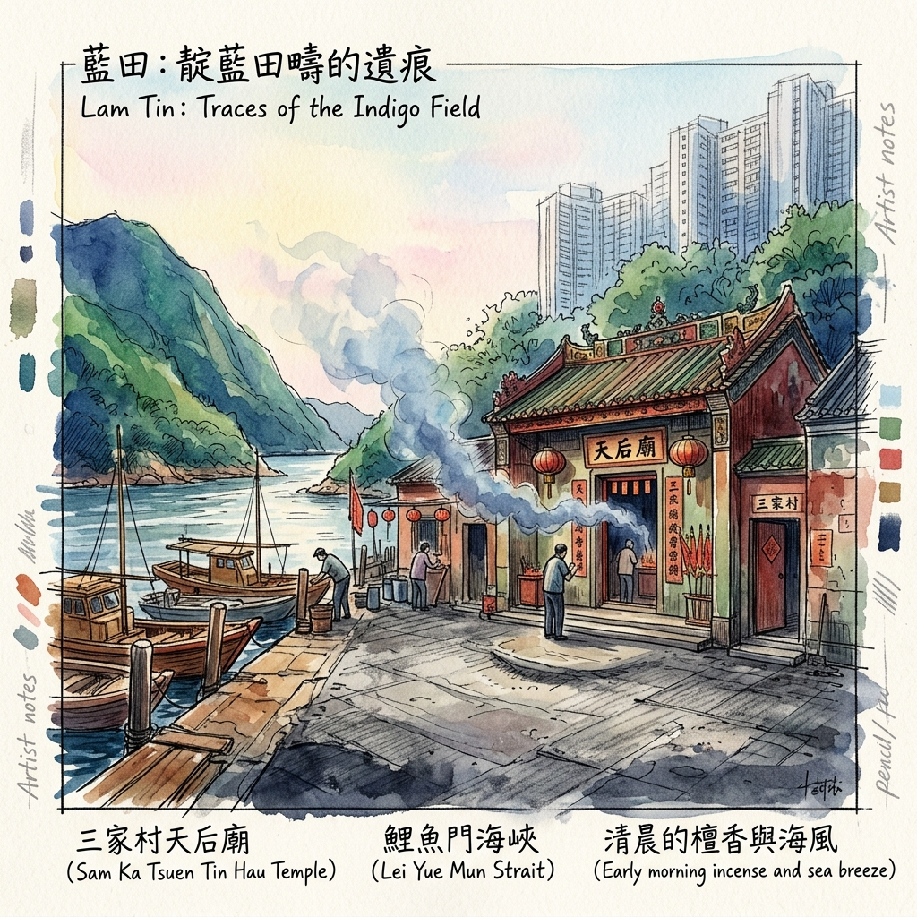
At Sam Ka Tsuen, the fishing hamlet at the Lei Yue Mun narrows, a small temple to the Goddess of the Sea has been burning incense in the direction of the strait for longer than any living person can remember. Tin Hau — Empress of Heaven, Protector of Seafarers, known elsewhere as Mazu — is not a generic deity of comfort. She is specifically the guardian of people who cross dangerous water. Her temple is built where it is not by accident or tradition alone, but by cosmological necessity: the threshold between land and sea, the point where safety ends and the crossing begins, is precisely where a guardian of crossings belongs.
Holographic Sensory Cue:
Sam Ka Tsuen Tin Hau Temple, early morning, northeast wind. The breeze is channelled and compressed by the narrows, arriving at the temple forecourt with more force than the open water alone would explain. The stone floor is worn concave — abraded to a slight hollow by generations of feet, so the surface is now measurably lower than the pavement surrounding it. The incense smoke inside drifts toward the strait and not away from it. The goddess figure on the altar is older in spirit than her gilded surface suggests: her expression stern, unsmiling, the face of someone who has encountered real storms rather than being asked to imagine them. At her feet: oranges, roast pork, a small wooden boat. Outside, the sound is the sound of water accelerating through constriction — a low, sustained friction against both shores simultaneously — and it is audible inside the temple, and it is found nowhere else on earth exactly like this.
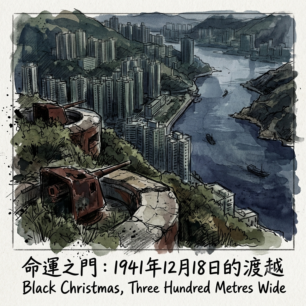
Two: Black Christmas, Three Hundred Metres Wide
On the night of December 18, 1941, the harbour was dark.
Japan had declared war ten days earlier — the Pacific assault coordinated with Pearl Harbor, two sides of the same catastrophe delivered simultaneously across the date line. In Hong Kong, the British garrison had already lost the mainland: Kowloon fell on December 13, and some fourteen thousand defenders — British regulars, Indian Army battalions, local volunteers, and two newly arrived Canadian formations — had retreated to Hong Kong Island and were now deployed across seventy-eight kilometres of coastline. Which is to say they were spread impossibly thin.
The two Canadian battalions are worth a moment's particular attention, because their story is one that English-speaking readers outside Hong Kong have largely forgotten. The Royal Rifles of Canada and the Winnipeg Grenadiers had arrived in Hong Kong only in November — dispatched by a Canadian government that would later be accused of sending them to a garrison with no strategic rationale and no prospect of relief, undertrained and underequipped. Their families in Quebec and Manitoba were still writing them letters.
On December 18, those letters were already history.
The Japanese 38th Division, under Lieutenant-General Sakai Takashi, had spent five days consolidating on the Kowloon shore. Their task now was the harbour crossing. The options were various — the entire northern waterfront of Hong Kong Island was exposed — but the tactical logic pointed with some force toward one place in particular. Three hundred metres wide. Dark. Flanked by high ground. The Lei Yue Mun narrows offered the shortest crossing in the harbour, the smallest exposure to defensive fire, and the closest approach to the island's eastern flank, where the terrain would provide cover immediately upon landing.
Elements of the Rajput Regiment held the Lyemun barracks and the waterfront on the island's side. A company of the Royal Rifles of Canada manned positions in the eastern sector under Brigadier Cedric Wallis. Both were stretched across far more ground than their numbers could cover.
The Gate That Broke Hong Kong
The Japanese crossed in motor launches and commandeered sampans, hitting multiple points of the harbour simultaneously to prevent any concentration of defensive response. The effect was a defence that could be everywhere and therefore was nowhere thick enough. The line broke before midnight.
Hong Kong surrendered on Christmas Day, 1941. In the city's collective memory, the date carries a weight it bears nowhere else in the English-speaking world: Christmas here is also the anniversary of a capitulation, a day on which the most festive occasion in the Western calendar became the occasion for a colonial catastrophe. Hong Kong calls it Black Christmas — 黑色聖誕 — and the two words together do something that neither word alone can do.
The military history of the crossing has been reconstructed, at length and with care, from war diaries and survivor accounts. But there is a silence at its centre that no official record has filled: the fishing families of Sam Ka Tsuen.
They lived on the Kowloon shore, adjacent to the crossing. They had nowhere to go. They sheltered in their homes and their temple and they heard — at very close range, across three hundred metres of water — whatever sounds a harbour invasion makes in the dark. No testimony from any of them has been published. In a night of enormous historical consequence, the civilian witnesses at the precise crossing point left no record. The Tin Hau temple at which they had prayed for safe passage through dangerous water — the goddess who guards the threshold — was the only witness that cannot be lost.
★ Resonance Node: Devil's Peak Battery
The heritage trail to the summit of Devil's Peak begins just above the Lam Tin residential zone and climbs through secondary forest that has been reclaiming the hillside since the last soldiers left. Within ten minutes of the final apartment block, the city sound falls away with a speed that feels physically improbable — you are still inside the urban envelope, in geographical terms, but the ridge has already absorbed it. The WWI and WWII gun emplacements at the summit are preserved in a condition best described as elegant ruination: concrete half-consumed by fig tree roots, steel observation slits oriented toward the narrows, magazine tunnels whose temperature drops three or four degrees as you step across the threshold. Stand at the observation aperture facing Lei Yue Mun. You are looking at the geography of December 18, 1941: the Kowloon shore below, the strait, the island rising beyond. The distance that decided everything is right there, measurable by eye, unchanged. On a clear morning, with the light coming from the east — from across the crossing direction — you understand something about the night of December 18 that no written account can quite deliver. The crossing was not just possible. It was, given this geography, almost inevitable. The question was only when.
Three: The Problem of the Name
There is a puzzle in the naming, and it is worth sitting with.
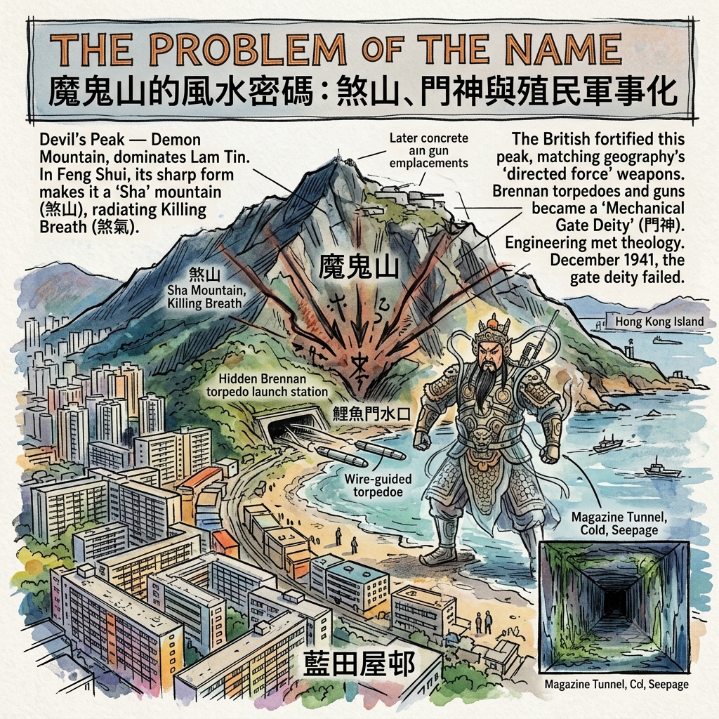
Devil's Peak — 魔鬼山 in Chinese, Demon Mountain — is the hill that dominates the eastern skyline above Lam Tin. Both languages arrive at explicit supernatural malevolence. Not "the hill" or "the summit" but the devil's, the demon's. In English, "devil" functions largely as an intensifier — Devil's Dyke, Devil's Bridge, the Devil's Punchbowl — suggesting something wild or extreme. In Chinese spatial cosmology, the naming carries sharper consequences.
In the feng shui tradition, a mountain is never simply a topographic feature. It is classified along a continuum from fully auspicious to actively harmful. A mountain that carries and transmits the dragon vein energy of the landscape downward to the settlement below is a living dragon — beneficent, protective, a source of 炁 (qi) for the community at its feet. A mountain whose form is sharp, angular, or threatening — one that seems to project energy outward rather than hold it inward — is identified as a sha: a source of 煞氣, often translated as "killing breath," a directed harmful force aimed at whatever stands in its line. A peak explicitly named for demons sits at the extreme end of this classification. It is a sha mountain, unambiguously, radiating its force outward toward the narrows below.
The puzzle: did the British cartographers name it, or did they hear the name from local fishing communities who had always understood this hill as something cosmologically aggressive in the landscape?
If the Chinese name predates British arrival — and the Xin'an County gazetteers, which documented this coastline before 1841, would settle the question — then we are looking at a community that had, for generations, lived beside a peak they understood as directing harmful force toward whatever faced it from across the water.
And then we look at what the British built there.
By the early twentieth century, the British had installed at the foot of Devil's Peak one of the world's first practical wire-guided weapons: the Brennan torpedo, an extraordinary piece of Victorian engineering in which a shore-based operator could steer a torpedo through the water by differential tension on two wires, correcting its course until it struck a hull. It was designed specifically for harbour defence — for preventing hostile ships from forcing a harbour entrance. One of the last operational Brennan installations in the British Empire was here, at Lei Yue Mun, aimed outward at the narrows. When the torpedo system was superseded, concrete gun emplacements replaced it. In two world wars, the hill was loaded with weapons directed outward toward the strait.
How Feng Shui Predicts Military Strongholds
The structural parallel does not require mysticism to be striking. Chinese cosmological tradition identified this peak as a sha mountain projecting directed force outward toward whoever faced it across the water. British military tradition installed at this same peak a succession of directed-force weapons aimed outward at whoever approached across that same water.
In Chinese popular religion, the figure placed at a gateway to intercept hostile passage is the 門神: the gate deity, whose job is to stand at the threshold and decide what crosses. The Brennan torpedo fired from the base of a hill that the indigenous tradition had always understood as a projector of outward force was, in the language of that tradition, a mechanical 門神 — a technological guardian of the same threshold that Chinese geomancy had named and theorised centuries before the Royal Engineers arrived.
The engineers didn't know the theology. The theology couldn't anticipate the torpedo. Both knew the geography.
In December 1941, the gate deity failed. Something came through.
Holographic Sensory Cue:
Devil's Peak magazine tunnel, mid-morning: the temperature drops at the threshold in a way that is startling even when you are expecting it — three or four degrees Celsius, immediate, as if the concrete has been storing cold since the last time anyone looked. The walls are damp with seepage that has left long dark vertical streaks in the aggregate. The smell is specific and unmistakeable: old concrete, sea salt carried inward by decades of harbour wind, and the particular organic note of enclosed spaces that have held, over long years, human alertness and human fear. Looking outward through the steel observation slit: the strait catches afternoon light. Hong Kong Island is close enough to seem touchable. In December 1941 darkness, the sound of the crossing would have arrived here before the sight of it — motor launches on flat water carry a long way when a ridge is funnelling sound from below.
Four: The Hillside Republic
After the war, the hills above Lam Tin filled.
The Communist victory of October 1949 produced one of the largest voluntary migrations in modern Asian history in one of the shortest time frames: somewhere between three-quarters of a million and a million people entered Hong Kong in roughly two years. They came from everywhere in China — Shanghainese factory owners who had loaded their machinery onto ships before the city fell; Cantonese farmers whose villages had been collectivised overnight; Hakka families whose clan networks stretched into Hong Kong's existing communities; former Nationalist soldiers, many very young, whose armies had simply dissolved around them. Hong Kong's population very nearly doubled in the span of years that other cities use to add a few neighbourhoods.
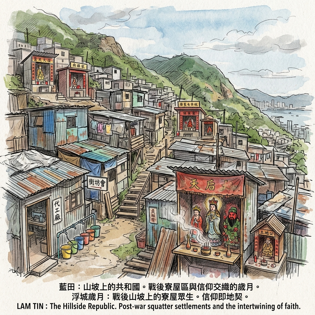
The squatter settlements that emerged on the hillsides of eastern Kowloon — including the slopes that rose behind what would become Lam Tin — were not the disorganised shantytown of urban mythology. They were informal cities, self-organised with the sophistication that necessity teaches and idealism never quite manages. Block committees managed water access and waste collection. Factory work happened in residential structures: garments were cut and assembled on the same surface where the family slept. Schools operated in spaces technically too small to meet any official definition of a classroom. And gods appeared very quickly.
This is worth slowing down for, because it is telling us something important about how these communities understood the relationship between spiritual presence and territorial claim.
In Chinese popular religious practice, establishing a shrine at a location — even a minimal one, a ceramic deity figure and an incense burner on a shelf — constitutes an act of cosmological consecration. The god, once invited, establishes a presence. That presence is, in the tradition's own terms, a form of residency that runs parallel to — and in some ways prior to — any legal title. The squatter communities had no official right to occupy the hillsides. But they had gods who had accepted invitations to be present there. The temple was a competing form of land claim, illegible to the colonial land registry and entirely legible to every member of the community that erected and maintained it.
The Refugee City In The Sky
What also happened on these hillsides was an accidental experiment in syncretism that no one planned and everyone participated in. Communities from provinces across China, carrying entirely different regional religious traditions — different deities, different ritual calendars, different relationships to the dead — found themselves within shouting distance of each other on the same slope. The Cantonese brought their Tin Hau and their Guan Yu. The Hakka maintained their Earth God shrines. The Shanghainese carried their own devotional patterns. In the compression of the hillside, with walls thin enough to hear the neighbours' prayers, these traditions began to cross-pollinate.
The distinctively hybrid popular religion of contemporary Hong Kong — non-sectarian, practical, tolerant of multiple deities sharing a single shelf, pragmatically ecumenical in ways that no formal religious institution could quite sanction — crystallised on these postwar hillsides. It was not designed. It was what happened when a million people who disagreed on theology were given no option but to live together in very small spaces.
When the government cleared the squatter settlements in the 1970s to build the Lam Tin Estate, the negotiations were hardest where they were about the temples. What to do with a deity who had agreed to be present in a place? The practical answer — move the shrine to the new estate — was correct in administrative terms and required considerable spiritual negotiation in the community's own terms. Where relocations succeeded, the god moved with the people. The hill retained, in its overgrown foundations and ceramic sherds, the memory of where the altar had been.
Five: Learning to Live Vertically
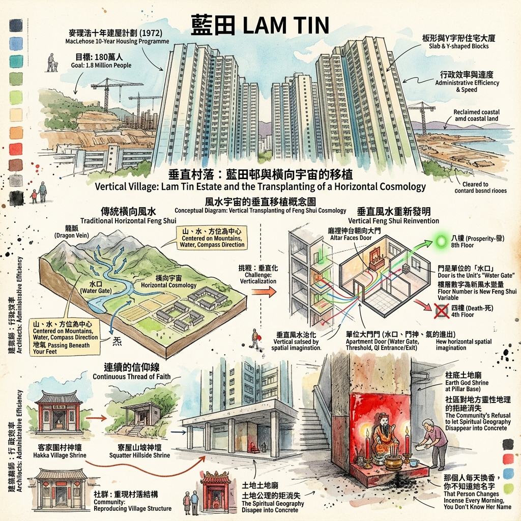
In 1972, Governor Murray MacLehose announced the Ten-Year Housing Programme: 1.8 million people to be housed in adequate public accommodation within a decade. Measured in per-capita terms and sheer construction speed, it was one of the most ambitious social housing projects any government had ever attempted. Lam Tin Estate was among its products — built in phases through the late 1970s and early 1980s on reclaimed coastal land and cleared hillside, housing tens of thousands of families in standardised slab blocks and Y-shaped towers.
The architects were not thinking about feng shui. They were thinking about floor-plate efficiency, construction cost per unit, and the mathematics of sheltering the maximum number of families on a constrained area of land. The towers they produced are not beautiful in any conventional sense. They are powerful in a different register: the physical record of an enormous collective effort to solve an enormous collective problem, built at speed, without the luxury of idealism.
What the architects could not have anticipated is what happened inside.
The Feng Shui Of The Concrete Sky
Feng shui is a horizontal cosmological system. It maps the relationship between mountains and water across a landscape; it concerns itself with the way 炁 (cosmic breath, qi) flows through valleys and pools around hills; it assumes a world in which you can physically see the mountain at your back and the water in front, in which the cardinal directions are meaningful at the scale of your daily life. It was developed for a world of courtyard houses and open fields, where the dragon vein passes beneath your feet and your ancestral graves are on the hillside behind you.
Place communities formed by that tradition on the eighteenth floor of a tower block. Then watch what they do.
The household altar, which in a village house faced a geographically determined direction aligned with the dragon vein and the water beyond, was reoriented to face the apartment's front door. The logic is not arbitrary: the door is where 炁 enters and exits the unit. The door is the apartment's water gate, its 水口, its threshold. The directionality of the landscape was compressed into the internal axis of a single residential unit. Meanwhile, ground-floor community spaces became the site for relocated temple shrines — the horizontal cosmological layer preserved as a physical stratum at the base of the vertical residential stack. And among residents, floor number became a new feng shui variable: the eighth floor (八, which in Cantonese sounds like 發, prosperity) was sought; the fourth (四, which sounds like 死, death) was avoided. The vertical axis had been colonised by a spatial imagination that was, originally, entirely horizontal.
Walk the ground level of Lam Tin Estate today. At the base of a pillar support, in the angle between a stairwell wall and a carpark entrance, you will find a small Earth God shrine. It may be nothing more than a ceramic figure in an alcove painted red, a pair of red candles, a bronze incense burner the size of a teacup. It is tended daily — the incense ash at its base has built up over decades, compressed and blackened, a sediment of ten thousand acts of morning devotion by someone whose name you do not know and will not easily find out. That shrine is the continuous thread running through Hakka villages, squatter hillside, and tower block: the community's refusal, across every form of displacement, to let the spiritual geography of a place disappear into concrete and administrative indifference.
The village became a settlement became an estate became a redevelopment. The shrine stayed.
What Feng Shui Knew Before Anyone Else Arrived
This is the argument that Lam Tin's geography has been quietly making for five centuries, in a language most of its visitors can't read.
The classical Chinese practice of feng shui — literally "wind and water" — is a system of landscape analysis that identifies the patterns by which 炁 (cosmic breath) moves through and accumulates within geographic formations. Two concepts from this system are directly relevant here.
The first is the 龍脈 (lóng mài), the dragon vein: the meridian of energy that descends from a mountain range along its ridgelines and terminates at a coastline or river. Dragon vein energy either pools beneficially — gathering in what feng shui calls a 穴, an acupuncture point in the landscape — or disperses into the sea and is lost. Lam Tin sits at the eastern terminus of the dragon vein descending from the Kowloon hills. The energy has nowhere further to go. It either gathers here or it doesn't.
The second is the 水口 (shuǐ kǒu), the water gate: the aperture through which the accumulated energy of an entire geographic basin enters or exits. The water gate is the single most critical node in any feng shui analysis of a harbour or river basin, because it controls what the entire system retains. A well-guarded water gate — flanked by strong mountains on both sides, narrow enough to hold — keeps the basin's energy within the system. An open or damaged water gate lets everything out.
The eastern water gate of Victoria Harbour is Lei Yue Mun.
The Kowloon hills guard it on one side; Hong Kong Island's hills guard it on the other. The passage between them is three hundred metres wide.
Now consider who else, and when, identified this same node as the critical controlling point:
Hakka fishing communities settled Sam Ka Tsuen at the narrows and built their Tin Hau temple facing the crossing — understanding it as the threshold requiring permanent divine protection. British military engineers, surveying Hong Kong's harbour defence requirements in the late nineteenth century, identified the Lei Yue Mun passage as the harbour's most critical vulnerability and fortified both flanking heights. Japanese invasion planners in 1941 identified the same three-hundred-metre gap as the optimal amphibious crossing point in the entire harbour. Civil engineers designing the Eastern Harbour Crossing in the 1980s placed its Kowloon portal at Lam Tin, at the same geographic node, because that is where the crossing logically belongs.
Four entirely separate knowledge systems — classical Chinese geomancy, Victorian military engineering, twentieth-century invasion planning, and postwar civil engineering — independently arrived at the same conclusion. This is the controlling point of the harbour system.
The remarkable thing is not that they agreed. Geographic determinism will produce convergent conclusions across any civilisational system sophisticated enough to read the landscape at scale. The remarkable thing is that Chinese geomancy had named, theorised, and spatially mapped this structural reality before any of the others arrived to confirm it — and that the vocabulary it used (water gate, dragon vein terminus, the critical threshold where energy either gathers or is lost) turns out to be a precise and accurate description of what was happening, expressed in a pre-scientific register that has been underestimated by everyone who hasn't looked closely enough.
Feng shui didn't predict the 1941 invasion. It identified a structural geographic fact that the 1941 invasion, like everything else that has happened at this location, was simply the latest expression of.
Everything Changes at the Narrows
There is a concept in anthropology — articulated most influentially by Victor Turner, drawing on the Latin word limen, threshold — called liminality. Turner studied communities in the midst of ritual transition: the condition of being between states, no longer what you were and not yet what you are becoming, suspended in the threshold itself. He found that this liminal condition, uncomfortable and uncertain as it always is, was also when people were most genuinely themselves — most capable of seeing clearly, most open to change, most creative precisely because the old structures had released their grip.
Lam Tin has always been a liminal place.
The Hakka villages were at the threshold between the inhabited peninsula and the open sea — the place where land runs out and the choice to cross begins. The battle of December 1941 was fought at the threshold between a colonial order and an occupation, and was decided in a few hours at the narrowest point of the crossing. The squatter communities existed at the threshold between the China that was gone and the Hong Kong that was being made — neither fully the past nor quite the future. The public housing estates house communities perpetually between where they came from and where they're going. And beneath all of this, the ancient water gate does what water gates have always done: it mediates passage. It is the place where the question is asked and the answer given.
Classical Chinese philosophy offers a phrase that describes what Lam Tin does and what it has always done: 上善若水 — the highest good is like water. Water benefits all things without struggling; it settles in places that others avoid; it finds its way through every narrow passage without ceasing to be what it is; it reaches the sea eventually, regardless of what stands between. The water gate does not resist the water. It shapes it. It focuses it. It makes the crossing possible by making it specific, by saying: here, and not elsewhere, is where you cross.
History passes through Lam Tin the way water passes through a narrows: faster at the constriction, carrying everything with it, leaving a mark on both banks.
The fishermen who prayed to Tin Hau at the water's edge understood this. The soldiers who manned the gun emplacements above understood it in their way. The families who rebuilt their community around a small shrine at the base of a concrete pillar — after the villages were gone, after the squatter settlements were gone, after the first wave of tower blocks was demolished and the second wave built — understood it most durably of all.
The gate doesn't close. The crossing keeps happening. The shrine keeps being tended.
If you stand at the Lei Yue Mun narrows at the turn of the tide, watching the current accelerate through the passage in the way that it always has and always will, you are watching the same motion that fishing families watched a thousand years ago, that defenders watched in December 1941, that ten thousand daily commuters are moving with right now, underground, in the same geography. The Eastern Harbour Crossing carries the city through the same three hundred metres, under the water instead of over it. The gate changed form. The crossing remains.
Everything changes at the narrows. This is where it has always happened.
If you'd like more historical travel writing like this — the stories that guidebooks don't tell, the histories embedded in places that look ordinary from the outside — subscribe to our newsletter. We go deep into one place each month and come back with what most people walk past.
Accessing the Physical Node
Getting There
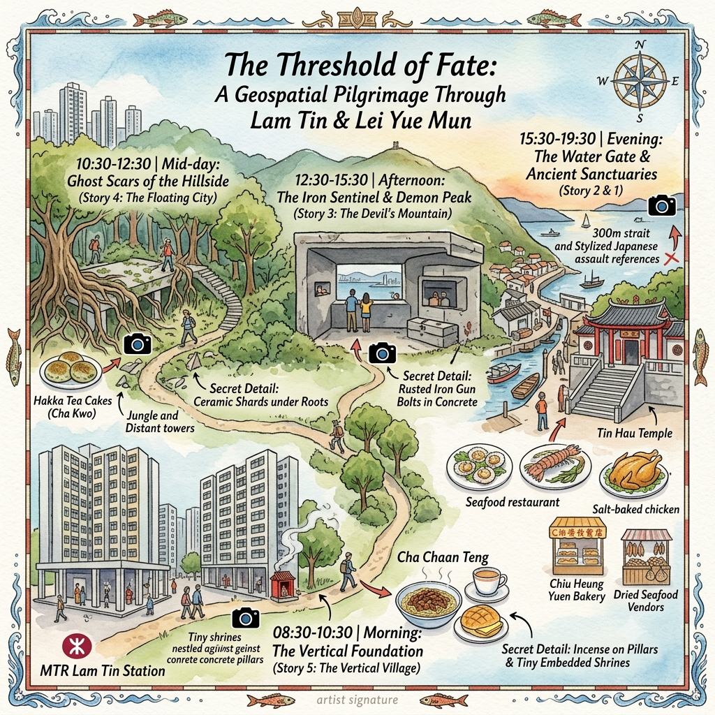
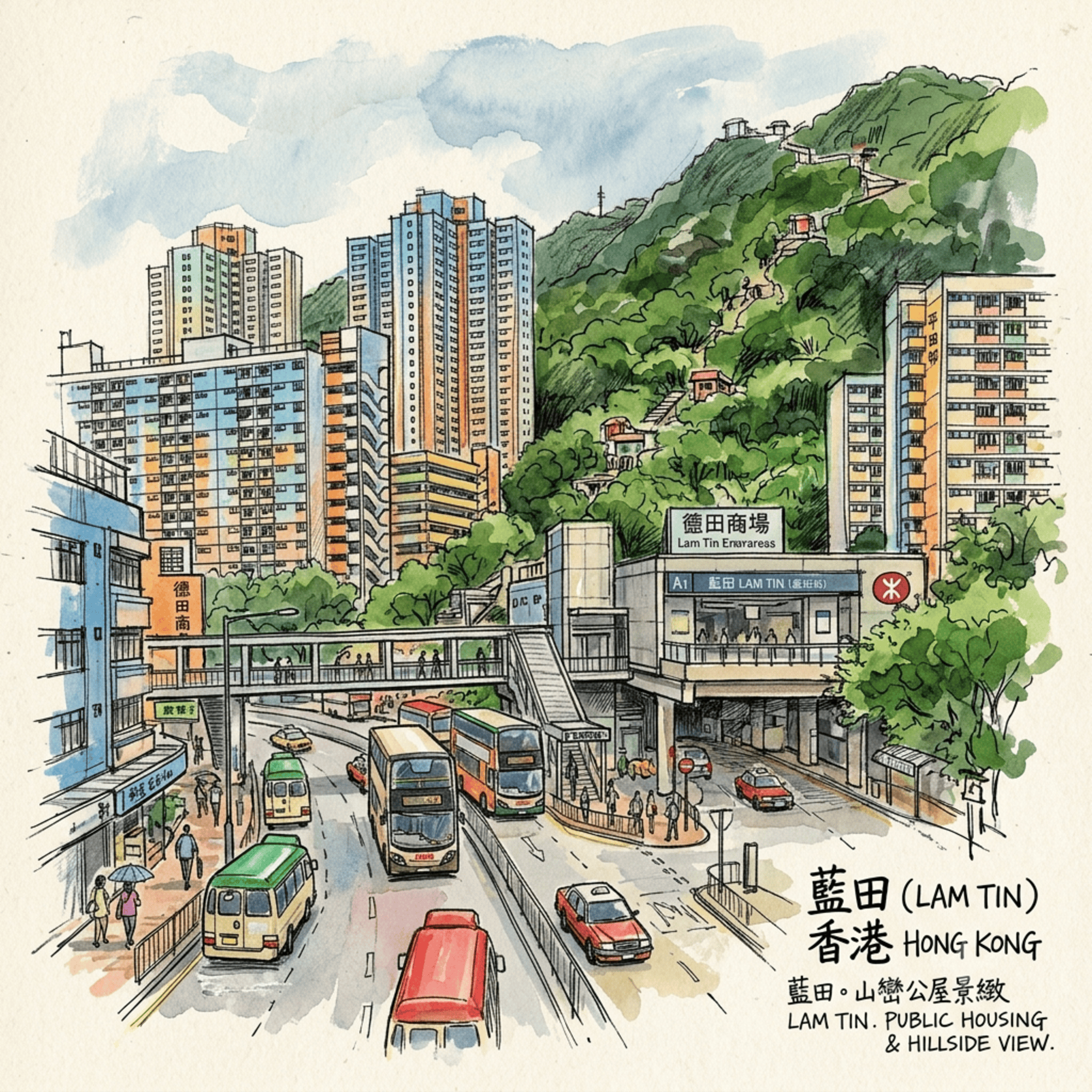
Lam Tin MTR Station (Kwun Tong Line) is the primary access point for this entire area. From the station exit, the lower estate level and the beginning of the Devil's Peak hiking trail are within a ten-minute walk. For Sam Ka Tsuen and the Lei Yue Mun seafront, take bus 14C from the station or a taxi — plan for ten to fifteen minutes depending on traffic.
Key Sites
Sam Ka Tsuen Tin Hau Temple, Lei Yue Mun: On the Kowloon shore of the narrows, this working temple faces the strait. It is not a tourist attraction; it is an active place of worship. Visit at dawn or in the early morning for the fullest experience: the combination of incense, sea wind, and the specific sound of accelerating water through the passage is found nowhere else quite like this in Hong Kong. The sea-facing temple forecourt is where the three-hundred-metre crossing begins, on the Kowloon side.
Devil's Peak Battery (魔鬼山砲台): A gazetted Hong Kong heritage site, accessible by hiking trail from above the Lam Tin residential zone. Allow one hour each way; wear proper hiking shoes; bring water. The WWI and WWII concrete fortifications are preserved in near-original condition — gun emplacements, observation posts, intact magazine tunnels with measurable temperature drops at the threshold. The summit provides the best surviving vantage point on the geography of the December 1941 crossing. Come in the morning: the light comes from the east, across the water, across the crossing direction.
Lam Tin Estate, ground level: No special access required. Walk the ground-floor civic spaces between the tower blocks and look at the bases of pillars, the corners of stairwells, the alcoves in retaining walls. You are looking for Earth God shrines: small, easy to overlook, tended. Finding them requires you to slow down and look at what is actually there rather than what the buildings announce themselves to be. That act of looking is itself the point.
Lei Yue Mun seafront walk: The Sam Ka Tsuen promenade follows the Kowloon shore of the narrows for several hundred metres. Walk it at dusk or at the turn of the tide. The current through the passage is visible — you can see the water accelerate as it enters the constriction, precisely as tidal and dragon-vein logic both predict. The view to Hong Kong Island across the crossing is unobstructed. This is where everything that happened at Lam Tin happened in relation to this specific piece of water.
Where to Stay
Accommodation directly in Lam Tin is limited. Kwun Tong or Kowloon Bay (both on the MTR Kwun Tong Line) offer multiple hotel options with straightforward access to all the sites above. For an alternative perspective — the island side of the crossing — consider staying in Sai Wan Ho or Shau Kei Wan on Hong Kong Island: you'll be looking across the Lei Yue Mun strait toward Devil's Peak, from the same position that the December 1941 defenders occupied. That view, in daylight, in quiet, is its own kind of historical document.
Further Reading and Research
- Hong Kong Museum of History, Tsim Sha Tsui: The permanent Hong Kong Story exhibition provides essential context for both the pre-colonial and WWII periods; plan two to three hours before visiting Lam Tin for the first time.
- Tony Banham's Not the Slightest Chance: The Defence of Hong Kong, 1941 (UBC Press, 2003): The most rigorous English-language account of the Battle of Hong Kong, with detailed unit positions and specific documentation of the December 18 crossings.
- Hong Kong War Diary (online, maintained by Tony Banham): Detailed mapping of WWII defensive positions throughout the Lei Yue Mun area, cross-referenced against archival war diaries.
- Lei Yue Mun Park and Holiday Village military museum (Hong Kong Island end of the narrows): A companion to Devil's Peak across the strait, covering the fortification of the island's eastern approaches. Together, the two sites give you both sides of the gate.
💡 Frequently Asked Questions (FAQ)
Q1: Why was Lam Tin originally called Ham Tin in Hong Kong history?
A1: Lam Tin was originally named "Ham Tin" (salty field) due to its coastal position along Kowloon Bay, where seawater-saturated soil made it ideal for imperial salt production during the Song Dynasty. In 1970, as the government constructed public housing estates in the area, officials renamed it "Lam Tin"—borrowed from a classic Chinese literary phrase meaning "jade born in Lam Tin"—to replace the unpromising original name with an inspiring symbol of community flourishing.
Q2: What is the story behind the giant dragon mural on Lam Tin Estate Block 15?
A2: Painted by the Housing Department in 1970, the giant dragon on Block 15 was a landmark of Hong Kong public housing. Popular urban folklore held that the mural was created to ward off fires and natural disasters in the rugged hills, eventually morphing into a local legend about a auspicious water dragon bringing good luck. Though the building was demolished in the late 1990s during redevelopment, the mural remains a cherished piece of local heritage.
Q3: How did Lam Tin transform from a salt field into a modern residential neighborhood?
A3: Lam Tin’s history reflects East Kowloon's dramatic transformation. Starting as a Song Dynasty salt pan, it later evolved into a stone quarrying and farming village during the Qing period. After WWII, hillside squatter villages rapidly expanded to accommodate incoming refugees. The government cleared these settlements in the 1960s to construct high-density public housing, ultimately paving the way for the modern residential town and transport hub seen today.
Reference and Further reading
First layer – Main sources of literature and institutions:
- Hong Kong Public Records Office (PRO): Land records, Crown Grants, colonial survey maps (1841 onward)
- Qing-dynasty Xin'an County Gazetteers (新安縣志): 1688, 1819, and 1866 editions — primary source for pre-colonial place names, communities, and land use
- Hong Kong Lands Department: Cadastral records for village boundaries in eastern Kowloon
- War Diaries, Rajput Regiment (British National Archives, Kew: WO 172)
- War Diaries, Royal Rifles of Canada (Library and Archives Canada: RG 24)
- Hong Kong War Crimes Tribunal Records (1946–47): British National Archives
- British National Archives (Kew): Royal Engineers records, Hong Kong Garrison command files (CO 129 series: Colonial Office, Hong Kong correspondence)
- Hong Kong Government Records Service: Fortification plans, colonial defence correspondence
- Ordinance Survey of Hong Kong: Historical maps showing Devil's Peak fortifications
- Hong Kong Housing Authority archives: Squatter clearance records, resettlement documentation (1970s–80s)
- Hong Kong Government Annual Reports (various years, 1950s–1980s): Statistical records of squatter population and clearance
- Hong Kong PRO: Resettlement Department records
- Hong Kong Housing Authority Annual Reports (1973–present)
- Hong Kong Town Planning Board records: Lam Tin Outline Zoning Plans (各年期)
- Census and Statistics Department: Population and household data for Lam Tin by census year
The second layer – secondary academic materials:
- Hayes, James. The Hong Kong Region 1850–1911: Institutions and Leadership in Town and Countryside. Archon Books, 1977. (Primary scholarly reference for colonial-era village communities)
- Ward, Barbara E. Through Other Eyes: Essays in Understanding "Conscious Models." Her fieldwork on Pearl River Delta fishing communities includes material on Tin Hau worship patterns.
- Journal of the Hong Kong Branch of the Royal Asiatic Society (JHKBRAS): Multiple volumes contain village-level historical research on eastern Kowloon communities.
- Banham, Tony. Not the Slightest Chance: The Defence of Hong Kong, 1941. UBC Press, 2003. (The most rigorous recent academic treatment; essential starting point.)
- Lindsay, Oliver. The Lasting Honour: The Fall of Hong Kong, 1941. Hamish Hamilton, 1978.
- Snow, Philip. The Fall of Hong Kong: Britain, China and the Japanese Occupation. Yale University Press, 2003.
- Hong Kong War Diary project (online resource maintained by Tony Banham): Detailed mapping of WWII defensive positions and unit locations.
- Banham, Tony. Not the Slightest Chance: The Defence of Hong Kong, 1941. UBC Press, 2003.
- Gillingham, Paul. At the Peak: Hong Kong Between the Wars. Macmillan, 1983.
- Edmonds, C.J., and H.J. Lethbridge: various articles in JHKBRAS on Hong Kong colonial military geography.
- Hong Kong War Diary project: Mapping of Devil's Peak fortification positions.
- Smart, Alan. The Shek Kip Mei Myth: Squatters, Fires and Colonial Rule in Hong Kong. Hong Kong University Press, 2006. (Essential revisionist analysis of official clearance narratives.)
- Smart, Alan. Making Room: The Politics of Squatter Settlements in Hong Kong. Hong Kong University Press, 1992.
- Salaff, Janet W. Working Daughters of Hong Kong: Filial Piety or Power in the Family? Cambridge University Press, 1981.
- Lau, Siu-kai. Society and Politics in Hong Kong. Chinese University Press, 1982.
- Smart, Alan. Making Room: The Politics of Squatter Settlements in Hong Kong. Hong Kong University Press, 1992.
- Mathews, Gordon. World City, World Dream: The Cultural Economy of Hong Kong. Various editions. (Includes material on estate community culture.)
- Lui, Tai-lok, and Stephen Chiu, eds. The Other Hong Kong Report. Chinese University Press (various editions).
- Chan, Selina Ching. "Politicizing Tradition: The Identity of Indigenous Inhabitants in Hong Kong." Ethnology 37:1 (1998).
Third layer – Supplementary information:
- Hakka community oral histories, Hong Kong Heritage Museum collection
- Living memory of elder residents from Lam Tin's earliest public housing intake (1980s)
- Sam Ka Tsuen village oral histories from the occupation period, if any remain in recorded form
- Japanese veteran memoirs regarding the Lei Yue Mun crossing specifically (translation required)
- Local folklore and oral tradition regarding spiritual associations with "Devil's Mountain" predating British nomenclature
- Oral histories from former military personnel stationed at Devil's Peak before 1941
- Oral histories of first-generation Lam Tin Estate residents who previously lived in the hillside squatter communities above
- Documentation of surviving Earth God shrines in Lam Tin Estate by local heritage researchers
- Estate-specific community newsletters or block committee records, if any survive
- Oral histories from long-term Lam Tin Estate residents documenting original allocation, community formation, and experience of redevelopment
- Temple committee records within the estate, if accessible
- Estate-specific community newsletters or block announcements from the 1980s–90s, if any survive in residents' possession
Historical gap:
- The specific village history of the Lam Tin area — clan names, founding dates, religious site locations, land-use patterns — is poorly documented in English-language scholarship and likely inadequately documented even in Chinese sources. The transition from village community to colonial/industrial landscape in eastern Kowloon has received far less scholarly attention than comparable transitions in the New Territories. This is a genuine and recoverable gap: oral history fieldwork with remaining elderly residents of Lam Tin and Sam Ka Tsuen could produce significant new documentation.
- The experience of the civilian Chinese fishing community at Sam Ka Tsuen / Lei Yue Mun during the night of December 18 is almost entirely absent from published sources. The tactical history of the crossing has been written from Allied military records; the civilian perspective — what was seen, heard, and survived from within the fishing village — is a significant and potentially recoverable gap through directed oral history collection with the oldest surviving community members or their descendants.
- The pre-colonial Chinese name and any indigenous spiritual associations of this peak are undocumented in published English-language sources. The specific operational history of the Brennan torpedo installation — including commissioning date, technical configuration, and when it was decommissioned — is not fully documented in accessible sources. The experience of local communities living in the shadow of an actively militarized peak during the period 1900–1941 — the noise, the labor demands, the disruption of fishing routes, the symbolic weight of colonial fortification on a peak named for demons — is entirely absent from the historical record.
- The specific squatter community history of the hills above Lam Tin — as distinct from the better-documented Kowloon City and Shek Kip Mei cases — is almost entirely undocumented in published scholarship. The religious life of these specific communities, the improvised temple histories, and the specific negotiations around shrine relocation during clearance are not addressed anywhere in the published record. This gap is recoverable through targeted oral history work with long-term Lam Tin residents. It should be treated as a research priority before the last generation with direct memory of this period is gone.
- The micro-history of religious and community life within Lam Tin Estate specifically — as distinct from general studies of Hong Kong public housing communities — is entirely absent from published scholarship. The estate's temple(s) and Earth God shrines, their histories, their community roles, and their survival across successive redevelopments have not been studied. The experience of successive redevelopment on long-term residents' sense of community identity and place has also not been studied at the level of this specific estate. Both constitute genuinely recoverable gaps through oral history fieldwork with a residential population that is aging and that carries irreplaceable institutional memory.
 Lawrence
 Lawrence
 Lawrence
Lam Tin is not the Hong Kong you came to see. It is the Hong Kong that was always there — before the skyline, before the harbour lights, before anyone thought to name this city a city. Come to the water gate. Watch the current move through the narrows. Listen to what the geography has been saying since before anyone was here to hear it.
The crossing is still happening.