Yonghe (永和): The Crossings That Made Taiwan’s Most Crowded District
Take a slow walk through Yonghe, a vibrant urban district of New Taipei City, with five surprising stories exploring hidden alleys, local markets, and daily neighborhood life.
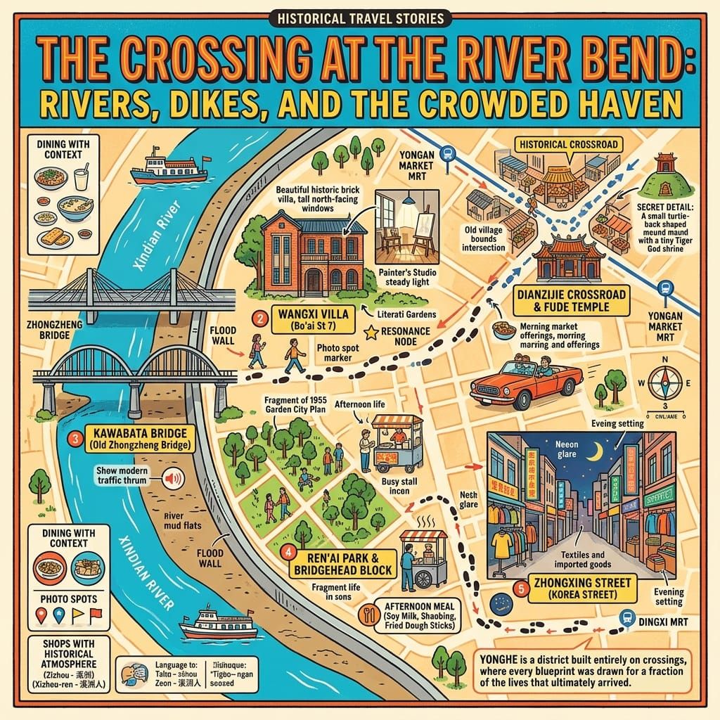
Historical Travel Stories · English edition
 Lawrence
This is a historical and cultural travel story exploring Yonghe, a densely packed urban district in New Taipei City, Taiwan. Through five surprising stories, it navigates old alleys, local markets, riverside pathways, and everyday neighborhood life to reveal the hidden layers of community heritage and local living behind the city's modern facade.
💡 Únete a una comunidad de viajeros exigentes. Solo tienes que introducir tu correo electrónico para acceder al instante a audioguías e itinerarios de un día, y llevar contigo nuestros exclusivos mapas históricos para recorridos a pie durante tu viaje.
The Bridge
The bridge carries a Japanese name for a district of Taipei, and no traffic. Its steel girders have been returned to their original paint. The deck is raw timber, lit from above and below at night. Kawabata Bridge (川端橋) opened in 1937; it was widened in the 1960s and again in 1972 until the old structure disappeared inside the new one, where it stayed for decades. In September 2026, with a modern bridge built beside it, it reopened to walkers. On the far bank is Taipei. On this one is Yonghe: 5.7 square kilometres, the most densely populated district in Taiwan. Nobody keeps a bridge that carries nothing unless it once carried a great deal.
1. Two Villages Reduced to Names
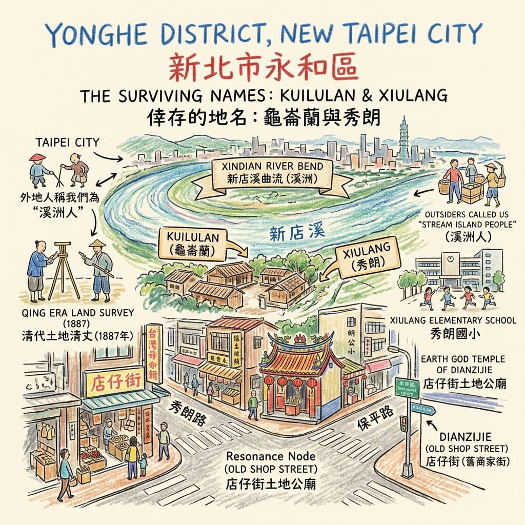
A few minutes from the bridge, Xiulang Road meets Baoping Road at what was once Dianzijie (店仔街), the shop street. At 10 Xiulang Road, a small temple to the Earth God stands near the crossing. Behind it, local people say, is a low plot shaped like a tortoise’s back that has never flooded. That is tradition, and nothing more. One popular article dates the temple to 1672; the Qing did not take Taiwan until 1683, so the date should be treated with caution.
The firmer evidence is older, and it is a list of names. In the 1650s, Dutch administrators compiled census registers of the Ketagalan villages around the Taipei basin. Two lie within today’s Yonghe: Kuilulan (龜崙蘭) and Xiulang (秀朗). The second was written Sirongh, Chiron and Chiouron, with no fixed spelling. The Qing later placed the area under the Baijie district (擺接堡). After Liu Mingchuan’s land survey of 1887 it held three settlements, Tanqian, Xiulang and Kuilulan, and the Japanese gazetteer of 1919 still lists them. “Xizhou” (溪洲), “stream island”, spread until outsiders called anyone from Yonghe a Xizhou person.
The Ghost Villages Of Yonghe
What the villagers believed about the river and the land is, as far as surviving sources show, unrecorded. This article will not invent a cosmology for them. What remains is vocabulary: Xiulang Elementary School, Xiulang Road, Xiulang ward. Even the meaning is unsettled. The scholar Weng Chia-yin (翁佳音) reads it as an Atayal-type expression for “a place with water”, and a gazetteer of 1717 places Atayal activity around Banqiao and Zhonghe. The names survived, but the speakers left no voice to check them against. Only in the 1990s did people of Ketagalan descent begin to speak publicly of their identity again.
Then came settlers from Quanzhou and Zhangzhou. A local saying has it that Quanzhou people opened Yonghe and Zhangzhou people opened Zhonghe. Quanzhou people worshipped Baosheng Dadi (保生大帝), the Great Emperor Who Protects Life; Zhangzhou people honoured the Holy King Who Opened Zhang. The Earth God was at the crossroads.
Resonance Node — the Dianzijie crossing. It was the centre of the three villages and Yonghe’s earliest commercial street. Dutch ledger names, Qing village boundaries and Hoklo worship of the Earth God all overlap here. Nothing marks it as special. It is simply a place where three layers of the record meet.
2. The Chrysanthemum Garden and the Name “Yonghe”
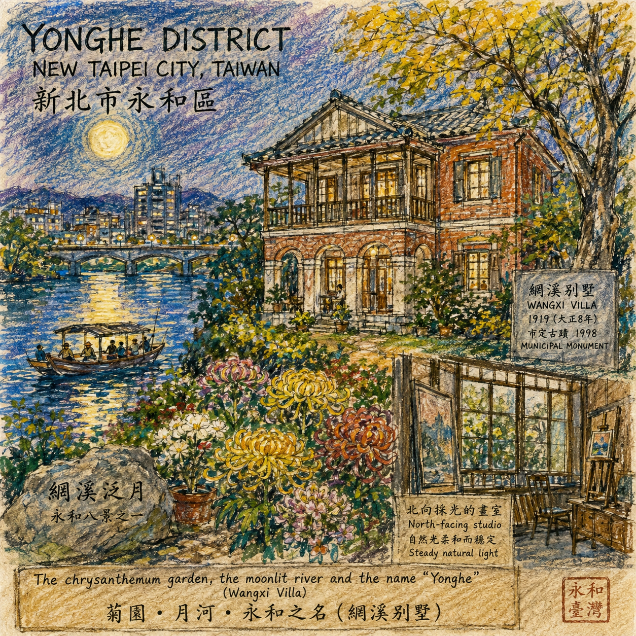
The studio on the upper floor of Wangxi Villa (網溪別墅), 7 Bo’ai Street, has large windows facing north. North light is steady and does not fall directly on canvas. The painter who added the room in 1947, Yang Sanlang (楊三郎), clearly understood that. But the house was not built for a painter. Around 1919 his father, Yang Zhongzuo (楊仲佐), raised it beside the river: two storeys of brick and timber in Japanese manner, in a garden known for chrysanthemums and orchids.
According to local sources, which are secondhand and need checking, Yang was born in 1875, served as chief writer of the Chinese section of the Taiwan Nichi Nichi Shinpo (臺灣日日新報), belonged to the Ying-she (瀛社) poetry society, and in 1919 co-founded a liquor company with his brother. In 1920 liquor became a government monopoly, and he withdrew to the riverside. Poets and notables came to the garden. Moonlit boating on the river here, Wangxi fan yue (網溪泛月), was counted among the eight views of Yonghe. The name Wangxi may come from fishermen who hung their nets by the stream. That is local tradition, not proof.
The Blueprint That Betrayed A Poet
A man who wrote Chinese for a colonial newspaper and made liquor under a licence left a garden to a district. In the late 1950s, when Yonghe was being separated from Zhonghe, Quanzhou families, Zhangzhou families and postwar arrivals from every province had to share one plain, and a name was needed. The name chosen was Yonghe, “eternal harmony”. Who proposed it is disputed. Some accounts credit Yang Zhongzuo; others say he only chaired the preparatory committee; one tourism source calls him the first township head. There is no settled answer.
His son left at seventeen on a merchant ship for Kyoto to study painting, later studied in France, and in 1934 helped found the Taiyang Art Association (臺陽美術協會) with Li Mei-shu (李梅樹), Chen Cheng-po (陳澄波), Liao Chi-chun (廖繼春) and others. His birth year is given as 1905 in some sources and 1907 in others.
The house nearly did not survive. The 1955 urban plan proposed an eight-metre road through the villa. In 1991, when the museum beside it opened, the painter was in hospital, still afraid that road widening would take the studio. The house was kept, listed as a municipal monument in 1998 and restored in 2003. A hope for harmony and a road that nearly ran through it occupy the same address.
Holographic Sensory Cue. The north windows are still there. The light they admit is even and indirect by design, not by accident.
Resonance Node — the studio’s north window. A poet’s garden, a painter’s workroom, a demolition that almost happened and a name about peace all sit behind one row of glass.
3. The Ferry, the Bridge and the Levee
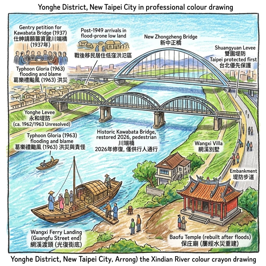
Before the bridge there was the fare. In 1822, the account goes, local gentry brought Baosheng Dadi to Yonghe from Bao’an Temple in Dalongdong (大龍峒保安宮), because Yonghe worshippers had to cross the river, and pay for the ferry, to reach him. The first Baofu Temple (保福宮) was a thatched hut on low ground, washed away repeatedly and rebuilt; it was enlarged to more than 1,200 ping only in 1971. These details come from popular reporting and should be checked against the temple’s own history.
The ferries gave way to the bridge in 1937. It was named for Kawabata-chō on the Taipei bank. A popular account says Yonghe gentry petitioned repeatedly and contributed money; that is unverified. After the war it was renamed Zhongzheng Bridge and widened twice, in 1962 or 1963 and again in 1972, as sources differ, so the original lay enclosed. Construction of a new Zhongzheng Bridge began in 2019, at a total cost of about NT$3.3 billion, and it opened in November 2024. The old bridge was kept, restored, and reopened to pedestrians on 21 September 2026.
The Suburb Sacrificed To Save A Capital
Bridges bring water as well as people. A former water-resources official recalls in an oral history that the provincial Water Bureau built a levee at Yonghe in 1962 because flooding there was severe, and that Taipei City, afraid the Yonghe levee would push floodwater to its own bank, built the Shuangyuan levee in response. Shuangyuan was completed on 30 June 1962; Wikipedia dates the emergency levees, Yonghe’s among them, to 1963. The year is unresolved. In September 1963 Typhoon Gloria struck. A reservoir engineer remembers homes in Zhonghe and Yonghe standing in water for days, and some residents blaming releases from Shimen Reservoir. One article says Yonghe’s population climbed sharply once levees and bridges were in place.
A student research paper adds a darker claim: that the Japanese administration had treated Yonghe as a restricted flood-relief zone, and that after 1949 newcomers, ignorant of the terrain, settled on the low ground and flooded first. It is plausible. It needs archives, not a student paper.
A bridge joins two banks. A levee makes each bank calculate where the water will go.
Holographic Sensory Cue. On today’s bridge the deck is timber, lamps light it at night, and cyclists must wheel their bicycles across.
Resonance Node — the double-column arched piers and steel girders of Kawabata Bridge. The restoration returned the girders to their original paint. For decades the old bridge was hidden inside the new widening; now it stands apart, the most direct physical witness to the crossing.
4. 1955: A Garden City, a Fleet from Dachen and a Breakfast Stall
Three things reached Yonghe in 1955.
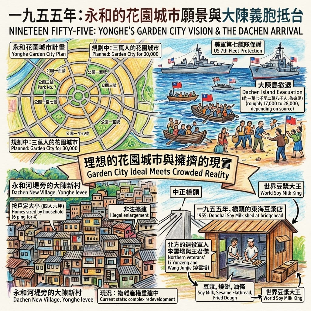
The first was a plan. The urban plan announced that year followed the garden-city idea, an English invention: Ebenezer Howard proposed it in 1902. It provided for about 30,000 people, seven parks and winding roads meant to slow traffic and let people walk between the green spaces.
The second was a fleet. In January 1955 Yijiangshan fell to Communist forces. From 8 February, the people of the Dachen Islands (大陳島) were evacuated under the protection of the US Seventh Fleet. The number varies by source: about 15,000, 17,000, 18,000 or nearly 28,000. One study says each person could carry only twenty or thirty jin of luggage, perhaps 12 to 18 kilograms. The government built Dachen New Villages across Taiwan. Yonghe’s lies by the river levee on about 8.2 hectares, with homes allotted by household size: about six ping for families of four or fewer, twelve for nine or more, and single people sharing.
How A Sudden Fleet Destroyed A Utopian City
The third was a shed. A widely repeated account says two veterans from the north, Li Yunzeng (李雲增) and Wang Junjie (王俊傑), set up at the bridgehead to grind soy milk, bake flatbread and fry dough sticks, first as Donghai Soy Milk and later as World Soy Milk King. When “Yonghe Soy Milk” became a chain brand, and who registered it, is also disputed: 1982 or 1985, by Lin Bingsheng (林炳生), who died on 7 August 2026. Another story says bridge workers carried the name across the island. That is legend, and its dates are unchecked.
Put side by side: a drawing for 30,000 people, with gardens and winding drives; a crowd of islanders carrying what they could; a stall at a bridgehead. Of the seven parks, only half of one is left. About a third of Park No. 1 became today’s Ren’ai Park. Park No. 4 (now the 823 Memorial Park) survived because when Yonghe was separated from Zhonghe it stayed on the Zhonghe side. When Yonghe became a township in 1958 it had under 40,000 people; in 2019 it had about 38,000 per square kilometre. The Dachen community is now one of the most legally tangled redevelopment sites in New Taipei, divided into seven units, and the work on unit six has begun.
Holographic Sensory Cue. The soy milk at World Soy Milk King is, by the shop’s own account, kept slightly smoky from the charcoal fire. That scent is still part of the morning there.
Resonance Node — the bridgehead and Ren’ai Park. One is where a shed grew into a brand; the other is what remains of a plan for 30,000 people, cut by Baosheng Road, its name still holding a trace of “Park No. 1”.
5. The Shandong Merchants Who Came from Korea
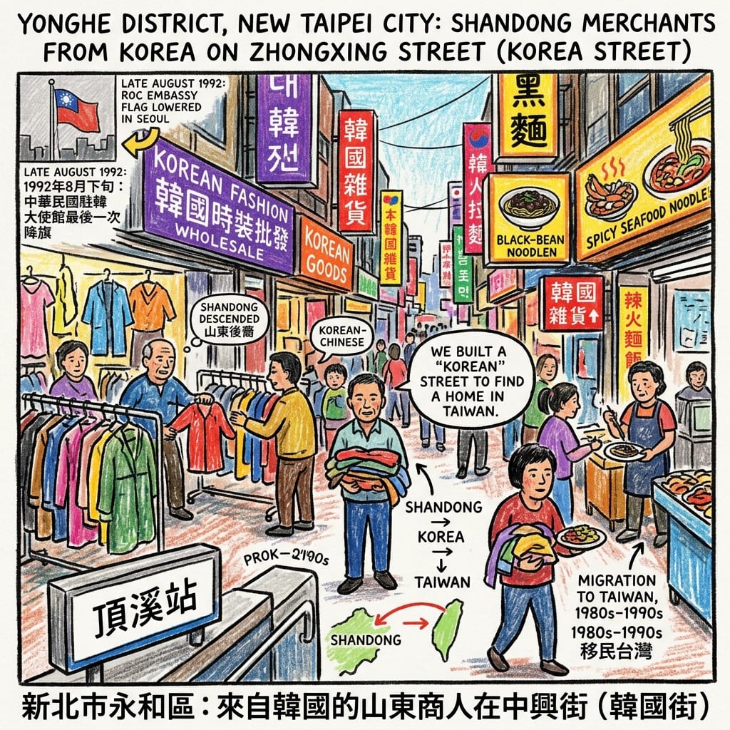
Out of Exit 1 of Dingxi MRT station and across the road is Zhongxing Street. Pillars carry short phrases in Chinese and Korean for bargaining, shops stack instant noodles and clothes, and Taegukgi flags appear on the signs. The street is called Korea Street. Most of those who built it are not Korean.
They are mostly Korean-Chinese of Shandong descent. Chinese had settled in Korea since 1882. In late August 1992 the Republic of China embassy in Seoul lowered its flag for the last time as South Korea recognised Beijing. Reports say many Korean-Chinese moved to Taiwan in the 1980s and 1990s, and settled in Yonghe. The earliest large importer of Korean goods was Nanshan Store on Zhulin Road; when Zhongxing Street was widened in 1979 the shops followed. The same reports describe women elders flying to Seoul’s wholesale markets, choosing clothes, shipping them and returning within two days, the stock snapped up by middlemen. The street once rivalled Taipei’s Wufenpu garment district; it is now officially “Korean Commercial Area”.
The Secret Architects Of Taiwan Korea Street
The contradiction lies in identity. Some reports say these families held a strong Republic of China identity, yet in Yonghe they made their living from Korean goods. One street, two languages, two homelands.
Resonance Node — Zhongxing Street itself. The same people, in the same row of shops, were Chinese expelled from a peninsula by diplomacy and Yonghe traders of Korean goods.
The Place Today
What survives: the bridge, the villa, the temple at the crossing, half a park, and a street with Korean lettering. What has gone: the voices of Xiulang and Kuilulan, the ferry landings, six and a half of the seven parks, the low look of the old Dachen village. What has changed: levees keep the river out, the MRT takes people across, and population produced today’s density.
Walk the lanes of Yonghe and notice that they curve. That is not carelessness: it is a line drawn in 1955 for 30,000 people, now lived in by more than 200,000.
Afterimage
Yonghe means eternal harmony.
When the name was written, the plain held fewer than 40,000 people. Now it holds about 38,000 per square kilometre.
Beneath the lamps on the old bridge, the girders are the colour they were in 1937.
Accessing the Physical Node
- Area: Yonghe lies on the south bank of the Xindian River, opposite Taipei, about 5.7 km².
- Kawabata Bridge: pedestrians only; cyclists must wheel their bikes. An official walking route runs from the Yang Sanlang Art Museum across the bridge to Kishu-an Literary Forest in Taipei, about 3.8 km.
- Wangxi Villa / Yang Sanlang Art Museum: 7 Bo’ai Street, Yonghe. Check opening hours with the museum before going.
- Dianzijie Fude Temple: 10 Xiulang Road Section 1.
- World Soy Milk King: at the Zhongzheng Bridge approach, beside Dingxi station.
- Korea Street (Zhongxing Street): Exit 1, Dingxi MRT station.
- Ren’ai Park: bounded by Yongping, Ren’ai, Baosheng and Bao’an roads.
- Dachen community: under redevelopment; view from the outside and do not enter the sites.
💡 Q&A (Frequently Asked Questions)
Q1 | How did Yonghe District in New Taipei City originate, and what is the historical context behind the "Shuanghe" (Yonghe and Zhonghe) administrative division? (Historical Evolution of Yonghe and Zhonghe Administrative Separation in New Taipei City)
A:The administrative establishment of Yonghe District stems from rapid post-war population growth and regional restructuring. Historical records indicate that during the Japanese colonial period and the early post-war era, both modern-day Yonghe and Zhonghe were administered together as Zhonghe Township. With the rapid expansion of the Taipei metropolitan area and an influx of mainland Chinese migrants and civil servants, Yonghe's population density prompted its official separation from Zhonghe Township in 1958, establishing Yonghe Town (meaning "eternal harmony"). It later upgraded to a county-administered city in 1979 and became Yonghe District following the municipal reorganization of New Taipei City in 2010. Despite administrative separation, the two districts remain closely linked geographically and socially, frequently referred to collectively by locals as Shuanghe.
Q2 | Is the original Yonghe Soy Milk restaurant actually located in Yonghe, and what is the true history behind Taiwan's iconic breakfast culture? (Origins of Yonghe Soy Milk and Mainlander Immigrant Food Culture at Zhongzheng Bridge)
A:Yes, the renowned "Yonghe Soy Milk" originated at the foot of Zhongzheng Bridge in Yonghe District, New Taipei City. According to local commercial history and oral traditions, in the early 1950s, demobilized soldiers and mainland migrants who relocated to Taiwan with the ROC government began setting up street stalls near the Xindian River banks to make a living, selling traditional northern Chinese soybean milk, flatbreads (shaobing), and fried dough sticks (youtiao). Their popularity and early 24-hour business hours quickly propelled the name to fame. However, "Yonghe Soy Milk" eventually became a generic trademark and popular moniker rather than a single unified corporate franchise; most original family-operated stalls did not form a modern chain, meaning independent shops bearing the name now operate across Taiwan.
Q3 | Why did Yonghe become one of the most densely populated administrative districts in Taiwan, and what historical factors shaped its grid street layout? (Urban Planning History, High Population Density, and Post-War Migration in Yonghe)
A:Yonghe District's status as one of Taiwan's highest-density areas is deeply tied to its rapid urbanization and post-war planning. Historical and urban planning documents show that during the 1950s and 1960s, government authorities and local planners designed Yonghe to accommodate an enormous wave of mainland immigrants, civil servants, and military dependents. Planners adopted Western-influenced grid road networks supported by commuter links across Zhongzheng Bridge. However, due to its constrained geographic area (approximately 5.7 square kilometers) immediately adjacent to central Taipei, rapid private construction and multi-story apartment development quickly overwhelmed the space, resulting in today's tightly packed, high-density urban landscape.
¿Quieres seguir las rutas históricas que he seleccionado directamente desde tu teléfono mientras caminas? Haz clic para unirte al mapa exclusivo de recorridos históricos en Google titulado "Historical Travel Stories": impórtalo a Google Maps en tu teléfono con un solo toque y deja que te guíe mientras visitas cada lugar histórico en persona.

📖Referencias y lecturas adicionales📖
Fuentes primarias (archivos y materiales históricos oficiales)
- National Cultural Memory Bank: Yonghe Wangxi Villa
- Water Resources Agency oral history on Taipei flood control
- New Taipei Tourism: Yang Sanlang trail
Materiales de nivel 2 (trabajos académicos)
- Taiwan Indigenous Peoples Knowledge Net: Ketagalan
- Insight (Indigenous Peoples Foundation): Ketagalan
- NTNU master's thesis on Typhoon Gloria
- Cheng-po Foundation: Yang Sanlang in France
- Wikipedia: Yonghe District (zh); Wangxi Villa; Ren'ai Park; Taipei flood control plan; classical-Chinese entry
- Taipei Times on the Dachen evacuation
- Korea JoongAng Daily: 1992 break in relations
- Dachen compilation (HLC student paper) (cites a research project; treat as secondary)
Información de nivel 3 (Información complementaria)
- 1998 student project 前進龜崙蘭──永和之美
- Jim Lee: New Taipei Indigenous place names
- LTN: Wangxi Villa profile; LTN: Kawabata Bridge history; LTN: reopening 21 Sept 2026
- UDN: Kawabata Bridge reopening; UDN: arts corridor; UDN River: earliest Taipei flood works; UDN: Lin Bingsheng obituary
- GVM/Vocus on Zhongzheng Bridge
- Threads post summarising the Yonghe gazetteer on Yang Zhongzuo
- UDN blog: Shimen Reservoir oral account
- Our Island (PTS); M+; BEYOND
- NOWnews: Dachen redevelopment; CommonWealth: Dachen community; CommonWealth Smile Taiwan: Dachen food
- The News Lens: soy milk; NOWnews: soy-milk origin; Tatler Asia
- UpToGo: Korea Street; Foodnext; CommonWealth Smile Taiwan: Korea Street
- CommonHealth: Baofu Temple; Money Weekly: Dianzijie Fude Temple; Spectral Codex: Yonghe; CNA: Master Hsin Tao
 Lawrence
 Lawrence
 Lawrence
 Lawrence